
25 November 2018
Planet Labs SkySat image of the Yarlung Tsangpo valley-blocking landslide
Planet Labs SkySat image of the Yarlung Tsangpo valley-blocking landslide
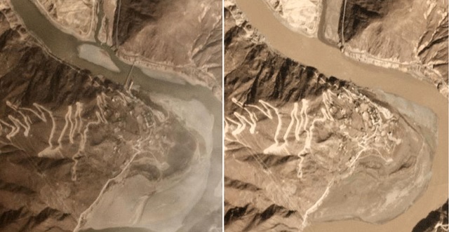
In the last few days Planet Labs have succeeded in capturing a gorgeous SkySat (very high resolution) image of the Yarlung Tsangpo landslide dam. As a reminder, this is a large landslide in Tibet, which originated from a rock and ice avalanche on a glacier. The events has occurred on two occasions in recent weeks, both of which have blocked the valley.
The image is below:-
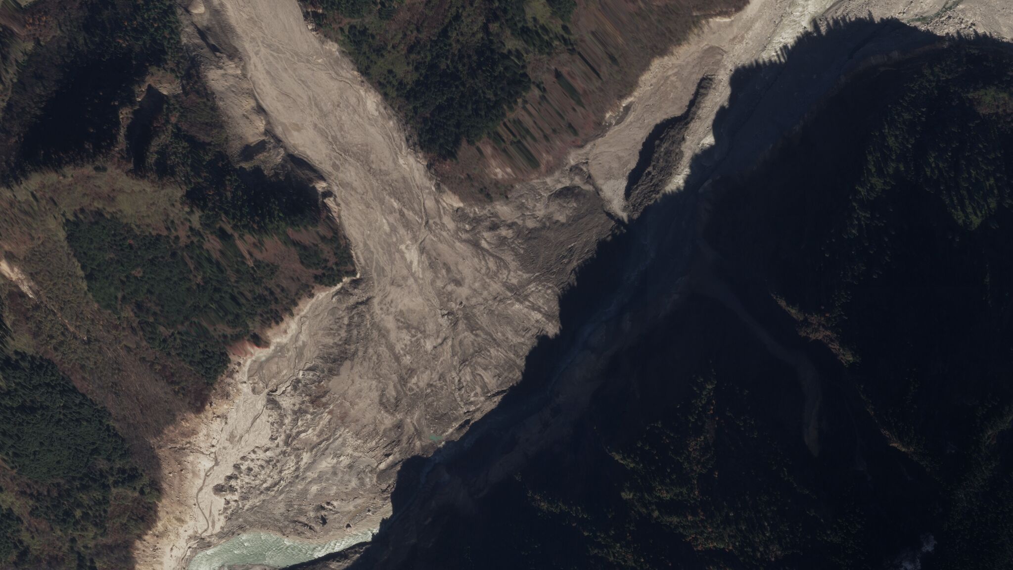
Planet Labs SkySat image of the Yarlung Tsangpo landslide in Tibet. Planet Labs image, used with permission. Copyright Planet Labs.
.
The location of the breach of the dam is very clear, meaning the the blockage is not impounding a significant amount of water now. Note that there is still a large volume of sediment in the channel though; presumably this will be eroded away in time. This erosion is ongoing – compare the colour of the river water on the upstream and downstream sides of the blockage.
The image provides detail of the chronology of the emplacement of the landslide and of subsequent modification of the landslide mass. It is notable that the landslide spread out both upstream and downstream of the junction with the main channel. Some erosion of the landslide track can now be seen as well. The original landslide mass would have comprised of both ice and sediment; the former will now be thawing, leaving just the mineral matter in the valley.
The reasons for this large glacial landslide remains unclear, but large rockslides and glacial landslides are becoming more common as the climate change crisis rapidly increases rates of melting on glaciers and in permafrost slopes around the world.
Reference and acknowledgement
Thanks to Robert Simmon, Senior Data Visualization Engineer, and his colleagues at Planet Labs for capturing this image and for processing it.
Planet Team (2018). Planet Application Program Interface: In Space for Life on Earth. San Francisco, CA. https://www.planet.com/
Video: a spectacular double flow-type failure from Kerala, India
Video: a spectacular double flow-type failure from Kerala, India
I have come across a spectacular video of flow-type landslide, apparently collected in Kerala, India. The video, which was posted to Youtube on 21st November 2018, has no detailed explanation associated with it. That is unfortunate as it is genuinely spectacular. The video should be visible below:-
.
The landslide appears to occur in two phases, initially a dynamic failure that splinters and destroys the trees bordering the river:-
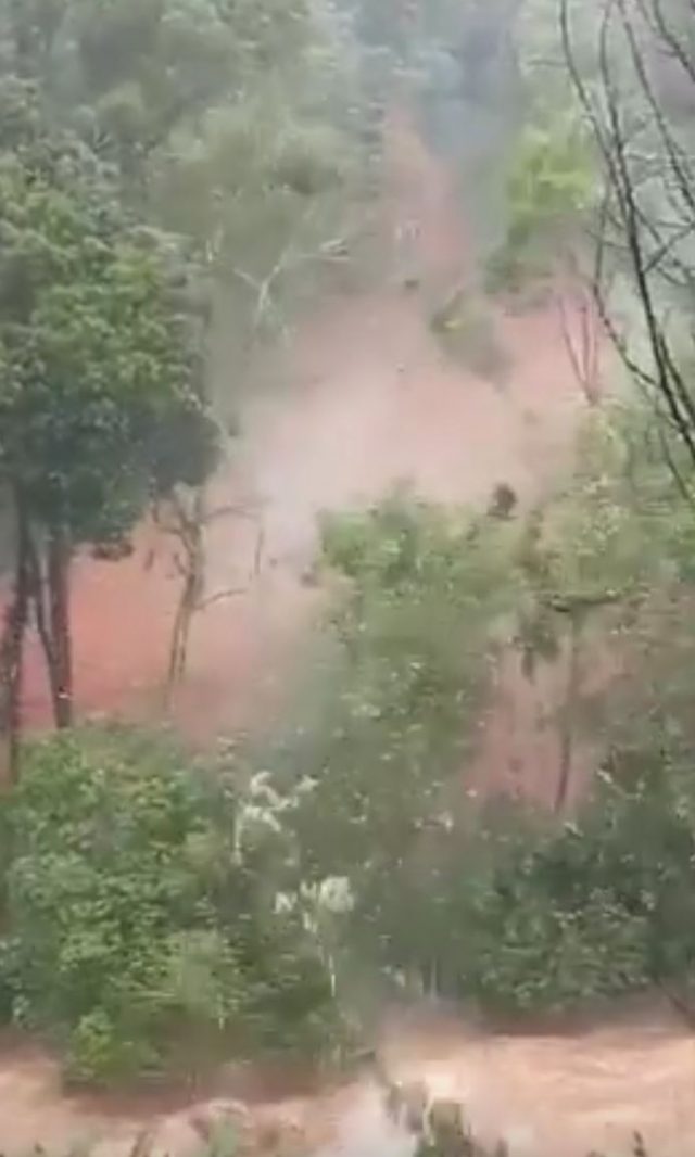
The initial failure of a channelised flow in Kerala, India. Still from a video posted to Youtube on 21st November 2018
.
Note that this landslide has clearly stated much higher up the slope as after the slide a track is visible disappearing into the distance. This initial failure is then followed by a very large, very rapid flow type failure along the track of the first landslide:-
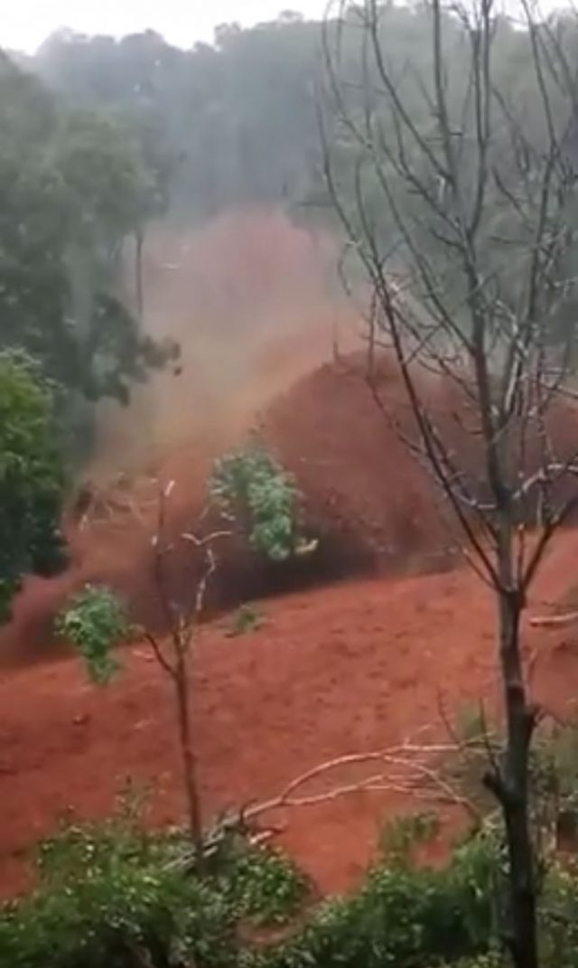
The second phase of the rapd, flow-type failure in Kerala, India. Still from a Youtube video posted on 21st November 2018.
.
This second phase is much more rapid, with a higher volume, than the first. It is sufficiently mobile that the flow crosses the river, even though it is in flood, and super-elevates to the level of the observers. This could have been very serious.
The origin of this double failure is not clear, but I am reminded of the very dramatic Lantau island landslides in Hong Kong in 2008, one of which was also caught on video. These started as comparatively small, shallow failures high on the hillside that transitioned into large-volume, channelised debris flows that entrained significant amounts of material. Note that in the case of the Kerala landslide in this video that material involved appears to be deeply weathered (red in colour) soil and rock, which might also hint at a similar mechanism.
It is rare to capture a channelised flow such as this coming straight at the camera. That they cause such high losses is unsurprising in light of this video.
22 November 2018
Pre-failure analysis of the Fagraskogarfjall landslide
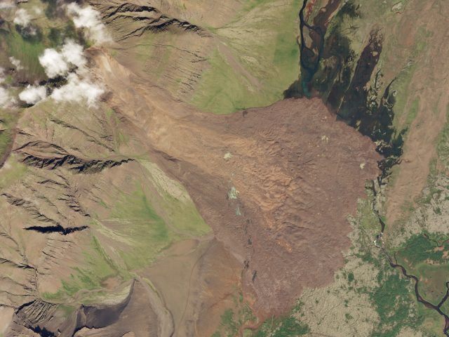
Planet Labs SkySat image of the Fagraskogarfjall landslide in Iceland. SkySat Image dated 19th July 2018, used with permission.
Pre-failure analysis of the Fagraskogarfjall landslide
Back in July I wrote about the Fagraskogarfjall landslide, a very large failure that occurred in western Iceland, inundating a large area of farmland. The volume of the failure is at the upper end of the scale – up to 20 million cubic metres – and it extended over 2.5 km. Fortunately this remote area of Iceland is sparsely inhabited, so there was no loss of life.
Large landslides such as this are generally predated by a long period of creep deformation – slow movement in which the failure develops progressively through time, often associated with the development of the final failure surface. This creates an opportunity to anticipate the location of major failures is creep deformation can be assessed. Whilst simple in concept, this is hard in practice. Measuring creep is difficult over large areas; we don’t really understand how different types of creep operate (do all slopes creep for example?); and can we differentiate between creep that might lead to catastrophic failure and creep that will not?
The advent of InSAR – the measurement of surface deformation using radar satellite data – potentially provides the answer to some of these questions. If it is possible to measure deformation over large areas on a regular basis then it may be possible to both understand background rates of creep and to identify those areas that might suffer a major failure. This is without doubt one of the most exciting areas of landslide science at the moment. I have noted previously that InSAR now provides the basis for measuring creep deformation with high levels of precision, and that wide area InSAR techniques are becoming available. Later this month Norway will launch a nationwide ground deformation map, a prospect that is immensely exciting.
NPA Satellite Mapping have looked at InSAR data for the period leading up to the failure of the Fagraskogarfjall landslide. Their results are available in a PDF article. In this case they have used Differential InSAR between July 2017 and July 2018. Their results, shown below, indicate that the parts of the slope were moving at up to 2 metres per year in the period up to the failure event:-
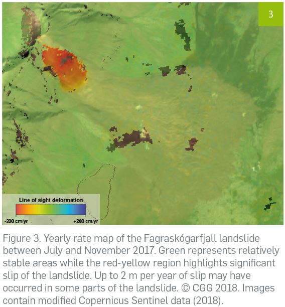
NPA Satellite Mapping analysis of pre-failure deformation of the Fagraskogarfjall landslide, including the original caption
.
There are several interesting aspects to this. First, of course, is that pre-failure creep of the Fagraskogarfjall landslide was detected. Second, the landslide showed differential movement, with the greatest accumulation of strain in the central portion of the landslide, in effect generating bulging that increased susceptibility to failure. And this, in this case the whole of the slope was moving (sometimes failure occurs in a portion of the slope, which then triggers failure through retrogression upslope or loading of lower slope portions). Thus, the InSAR data provides significant insight into deformation processes and the mechanisms of the slope failure.
Acknowledgement
Thanks to NPA Satellite Mapping for allowing me to highlight this example, and to Adam Thomas for bringing it to my attention. The analysis was undertaken using Copernicus Sentinel data.
Planet Team (2018). Planet Application Program Interface: In Space for Life on Earth. San Francisco, CA. https://api.planet.com
20 November 2018
Borba, Portugal: a major quarry landslide
Borba, Portugal: a major quarry landslide
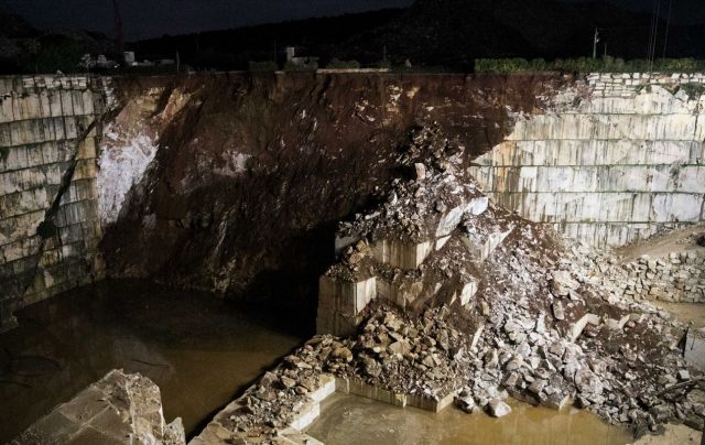
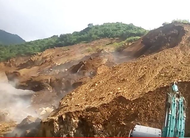
Yesterday (19th November 2018) a major landslide occurred at Borba in Evora, Portugal. This landslide is known to have killed at least two people, with a further four missing. Rescue operations are under way but are described as being exceptionally challenging. The prospects for those missing do not seem good given the nature of the landslide.
There is an excellent, detailed article in Portuguese on the Observador website, which includes the following image that gives an overview of the slide:-
The landslide close to Borba in Portugal on 19th November 2018. Image via Observador.
.
This appears to be a complex event, with the main failure consisting of highly weathered rock and soil. Bot note the smaller slide on the right hand side of the image, consisting of both rock blocks and some weathered material. In the very right hand corner the remains of a backhoe can be seen, partially buried. This gives an indication of both the scale of the landslide and the force of the movement. The image below shows this in more detail:-
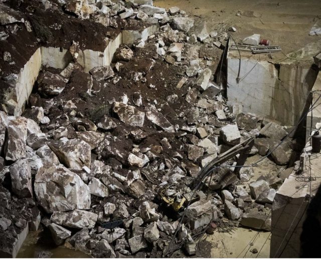
Detail of he landslide close to Borba in Portugal on 19th November 2018. Image via Observador.
.
The landslide has destroyed a road, EN255, at the top of the slope that linked Borba to Vila Vicosa. The cause of the landslide is not clear. Presumably the presence of the backhoe indicates that works were ongoing in the quarry, but there is no indication as to whether this was a factor.
The site appears to be the one shown on Google Earth below:-
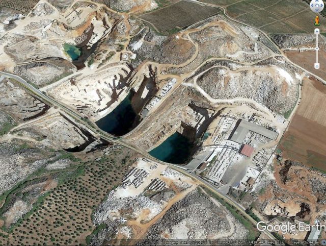
Google Earth imagery of the site of the landslide at Borba, Portugal on 19th November 2018.
.
Note the flooded old quarry sites, but also the area of more recent and apparently active quarrying on the left side.
Acknowledgement
Many thanks to Antonio Salvador for highlighting the article in Observador to me.
19 November 2018
Two interesting roadside failure videos from India and Nepal
Two interesting roadside failure videos from India and Nepal
Two videos have been posted to Youtube showing dramatic and interesting roadside failure events. The first appears to be from Nepal, some reports suggest the location was Lalitpur, and the caption indicates that it was associated with “stone mining”, although the failure itself appears to be on a haul road:-
.
The main collapse event occurs at 3:08, and the person holding the camera rotates the image as failure begins:-
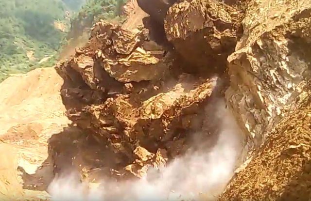
A roadside failure in a quarry in Nepal. Still from a Youtube video posted Fultung by on 16th November 2018.
.
An interesting aspect of this landslide is the way that it shows the retrogression of the landslide up the slope:-
The development of retrogression if a roadside failure in a quarry in Nepal. Still from a Youtube video posted by Fultung on 16th November 2018.
.
This appears to be yet another example of poor mining practices inducing instability that was entirely avoidable. There were substantial risks to the workers in a failure of this type, but fortunately in this case the collapse appears to have been anticipated. An excavator was reportedly destroyed however.
The second occurred in India, this time on a mountain road:-
.
The caption from one version of the video showing this roadside landslide says:-
A group of Indian villagers managed to cheat death after they felt rumbling beneath them and avoided a landslide..In a clip several villagers hold back as they notice a rumble in the ground beneath them, and predict that there is an oncoming landslide. They were travelling along the road in Chamba, Himachal Pradesh, in northern India on Sunday when they narrowly avoided the tumbling cliff side. Their hunch proved right and a portion of the mountain collapsed right before their eyes.The landslide blocked the Chamba-Holi road for nearly a day as local officials battled to clear the debris.
This is a splendid example of a collapse on a joint set that was sub-parallel to the slope. Undercutting close to the road caused the joints to daylight, allowing failure to develop:-
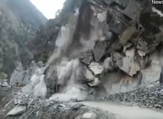
The development of a roadside failure in India. Still from a Youtube video.
16 November 2018
Images and video of the aftermath of the Jinsha River landslide
Images and video of the aftermath of the Jinsha River landslide
The breach event of the Jinsha River landslide in Jomda County, Tibet is now complete. The Planet Labs image below, collected on 15th November, shows the aftermath of the breaching (compare this with the image of the site when the dam was still intact):-
Planet Labs image of the Jinsha River landslide. PlanetScope orthotile, collected 15th November 2018, used with permission.
.
The image shows that most of the impounded water has been released and that there has been significant erosion of the landslide deposit in the process. The effects of the flood are clear downstream – this is the site of a major crossing of the Jinsha River – the image on the left is from before the flood, the one on the right is after:-
Before and after images of an area affected by the breach of the Jinsha River landslide. Planet Labs images, collected on 11th and 15th November respectively, used with permission.
.
The bridge that is clearly visible on 11th November has been swept away. The Free Tibet website has some detailed coverage of the effects of the breach of the Jinsha River landslide, including some remarkable video coverage of the breach event. This should be visible below, but as WordPress embeds files so poorly you may need to view it here.
.
This video appears to show the water flowing through the channel carved through the landslide, and collapses of the landslide deposit as the walls of the channel collapse. The Free Tibet site also has video of the effects of the downstream flooding, including collapsing buildings:
.
.
Free Tibet reports that the downstream damage is severe:-
The unceasing flooding has swept away whole villages and townships and destroyed crucial infrastructure networks including roads, bridges and schools. Townships of Drichu ka (Payul County), Ganzi (Tibetan Autonomous Prefecture), Polo (Jomda County) and Chamdo city (TAR) have been particularly affected.
The 900 year old Polo Monastery, which is “the most important and old Buddhist temple in the region” (according to Tibetan writer Tsering Woeser on social media), has been completely submerged by water. Its sacred religious artefacts have been ruined beyond repair, with monks and local Tibetans evacuated into the mountains.
Reference
Planet Team (2018). Planet Application Program Interface: In Space for Life on Earth. San Francisco, CA. Planet.com
14 November 2018
Jinsha River landslide: breaching has started
Jinsha River landslide: breaching has started
Xinhua, the official news agency of China, is reporting that the Jinsha River landslide at Jomda on the border between Tibet and China has breached.
Chinese authorities on Monday initiated a national emergency response after a landslide hit southwest China, leading to the formation of a barrier lake. The China National Commission for Disaster Reduction and the Ministry of Emergency Management jointly activated a level-IV emergency response, the lowest level, on Monday, the ministry said in a statement. A landslide hit the border area between Sichuan Province and Tibet Autonomous Region on Nov. 3, leading to the formation of a barrier lake blocking a section of the Jinsha River.
The article includes a number of images of the site, of which two are worth examining:-
Aerial image of the Jinsha River landslide at Jomda in Tibet. Image via Xinhua.
.
This image appears to be fairly early in the breach process. Note the evidence of stripping of vegetation on the opposite valley wall – this was a very energetic landslide event. Meanwhile, this image shows the breaching in more detail:-
A view from upstream of the Jinsha River landslide at Jomda, Tibet. Image via Xinhua.
.
Note the scale of the channel that has been excavated here to initiate the breaching event. The authorities have succeeded in lowering the height of the dam to an impressive degree, greatly reducing the size of a potential flood. They have certainly learnt the lessons of the successful management of the Tangjiashan dam ten years ago, and remain the absolute masters of these operation. Meanwhile, CGTN has tweeted:-
Local authorities have activated the level-I flood emergency response system and released evacuation notice as the flood in the Jinsha River barrier lake expected to hit Lijiang City, SW #China‘s Yunnan Province pic.twitter.com/kpHTmzAS7G
— CGTN (@CGTNOfficial) November 14, 2018
But there is very little additional information, and as the area is cloudy there is no satellite imagery.
.
12 November 2018
A dangerous, valley-blocking landslide in Jomda County, Tibet
A dangerous, valley-blocking landslide in Jomda County, Tibet
On Sunday Xinhua reported heightened concern about the Jomda County landslide dam in Tibet:-
More than 25,000 people have been evacuated as the water levels continue to rise in a landslide-formed barrier lake in Tibet Autonomous Region, local authorities said Sunday. The municipal government of Changdu in Tibet said the water level has risen 57.44 meters with an estimated 469 million cubic meters of water storage as of 9 a.m. on Sunday. As of Saturday, 42 temporary settlements, equipped with basic living necessities, have been set up for relocated villagers, with medical teams stationed near the settlements.
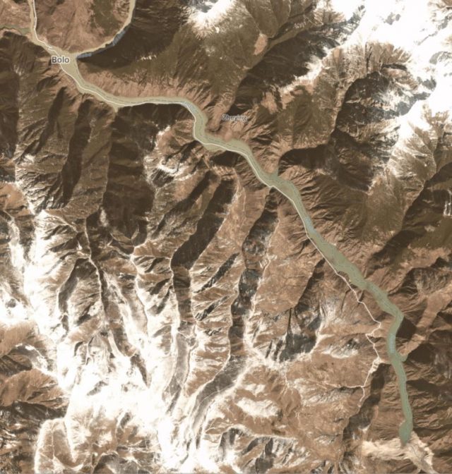
I reported on this landslide almost a fortnight ago. It is now clear that a second very major failure has occurred at this site, blocking the valley completely. This Planet Labs image, collected today (12th November 2018 at 03:40 am UT), shows the scale of the landslide and of the blocked valley:-
The major valley-blocking landslide in Jomda County, Tibet. Planet Labs 3-band PlanetScope scene collected on 12th November 2018, used with permission.
.
This Planet Labs image, collected on 10th November, shows the scale of the lake that has developed:-
The lake formed by the major valley-blocking landslide in Jomda County, Tibet. Planet Labs 3-band PlanetScope scene collected on 10th November 2018, used with permission.
.
Whilst this image shows the scale of the threat to the town of Bolo, upstream from the dame (the location can be seen in the image above):-
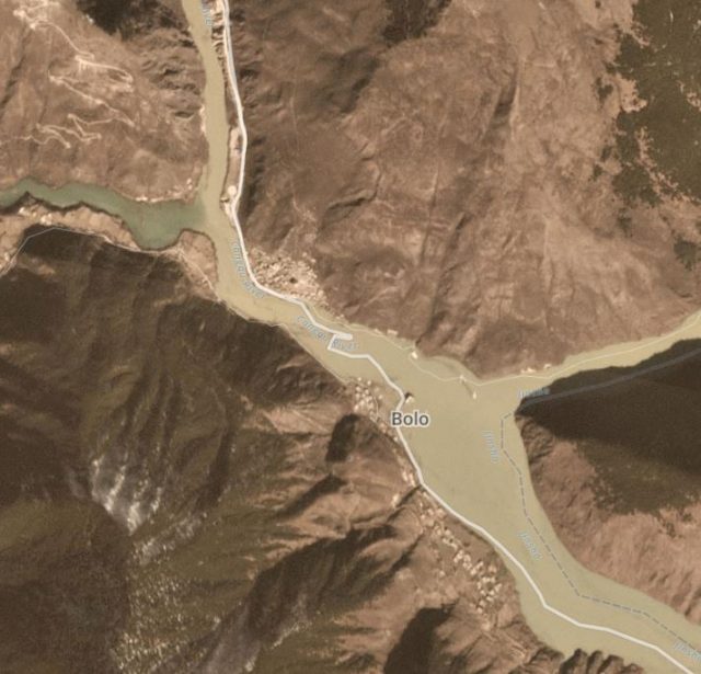
Flooding in the vicinity of the town of Bolo induced by the lake formed by the major valley-blocking landslide in Jomda County, Tibet. Planet Labs 3-band PlanetScope scene collected on 10th November 2018, used with permission.
.
This looks to be a dangerous situation that needs very careful management. Some reports suggest that overtopping is expected today (12th November).
Reference
Planet Team (2018). Planet Application Program Interface: In Space for Life on Earth. San Francisco, CA. Planet.com
9 November 2018
Landslides from the M=6.7 6th September 2018 Hokkaido Iburi-Tobu Earthquake – a first technical report
Landslides from the M=6.7 6th September 2018 Hokkaido Iburi-Tobu Earthquake – a first technical report
On 6th September 2018 a M=6.7 earthquake struck Hokkaido in Japan. This event, now known as the Hokkaido Iburi-Tobu Earthquake, was remarkable for the number of landslides that it triggered. I posted extensively about it at the time, and thereafter. The journal Landslides has an initial short report about the landslides triggered by this event (Yamagishi and Yamazaki 2018). The key points that they note include:-
- Landslides claimed 36 lives out of a total of 41 fatalities in total, thus representing the most significant impact of the earthquake.
- Landslides were triggered over a 20 x 20 km area in the vicinity of Atsuma Town.
- To date over 6,000 landslides triggered by the earthquake have been mapped.
- Interestingly however, only about 1,000 debris deposits have been identified. Whilst this might seem paradoxical, it is a sign that many of the landslides combined to form a single, complex deposit.
- Most of the landslides were shallow failures, with a planar or spoon-shaped rupture surface.
- Most of the landslides occurred in airfall ash and pumice layers, typically 1.5 m thick, erupted from Tarumai volcano at about 9000 years BP.
The authors speculate that the large number of landslides triggered by this earthquake was a result of the vulnerability of the local geology to seismically-induced triggering, possibly compounded by high groundwater levels as a result of the recent passage of Typhoon Jebi, which had deposited over 100 mm of rainfall in the preceding three days.
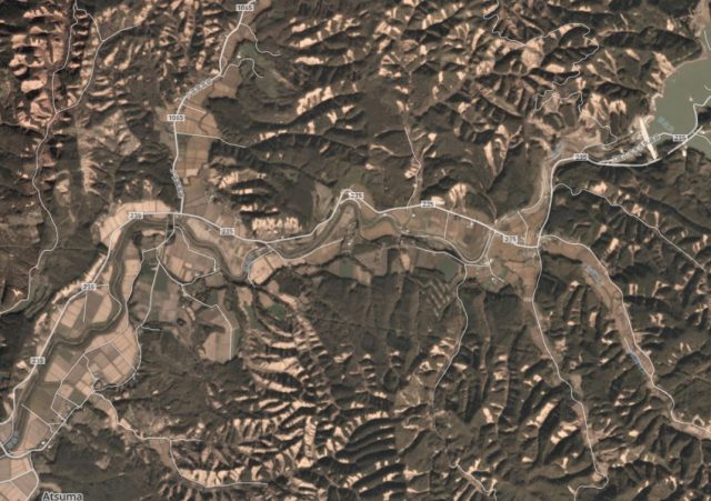
Planet Labs image showing landslides triggered by the 6 September 2018 M=6.7 Hokkaido Iburi-Tobu Earthquake. 4-band Planetscope image collected on 20th October 2018, used with permission.
.
Reference
Yamagishi, H. & Yamazaki, F. 2018. Landslides by the 2018 Hokkaido Iburi-Tobu Earthquake on September 6. Landslides. https://doi.org/10.1007/s10346-018-1092-z
Planet Team (2018). Planet Application Program Interface: In Space for Life on Earth. San Francisco, CA. https://www.planet.com/
7 November 2018
Mannen rockslide: The postman always rings twice; two post-glacial stability crises with multiple catastrophic rock-slope failures – is there more to come?
Mannen rockslide: The postman always rings twice; two post-glacial stability crises with multiple catastrophic rock-slope failures – is there more to come?
Guest post by Paula Hilger, NGU
Mannen (The Man) is one of Norway’s most threatening mountains. During the past five years its activities provoked 11 evacuations of the valley’s inhabitants and train disruptions along one of the country’s most scenic routes. In Norway, the responsibility for early warning of rock-slope failures and connected necessary actions lies with the Norwegian Water and Energy directorate (NVE). The concern is continuously increasing activity in a relatively small rock mass (130,000-180,000 m3), which is riding on a huge deep-seated rock-slope instability. It experiences seasonal acceleration phases at the end of each summer, when local ground temperatures exceed 0°C.
In 2008, the Geological Survey of Norway (NGU) classified the unstable rock slope at Mannen as a high-risk site, due to deformation rates of 2-5 cm per year of an approximately 5 million m3 rock mass, with potentially severe consequences. The latter may result in the damming of the Rauma river with subsequent outburst floods, threatening the touristic town of Åndalsnes. Hence, the instability is continuously monitored by NVE. The sliding surface of the rockslide crops out at the transition of the steep rock slope to the plateau-like top of the mountain. Twenty metres of absolute displacement demonstrate a long history of gradual sliding activity (Photo 1).
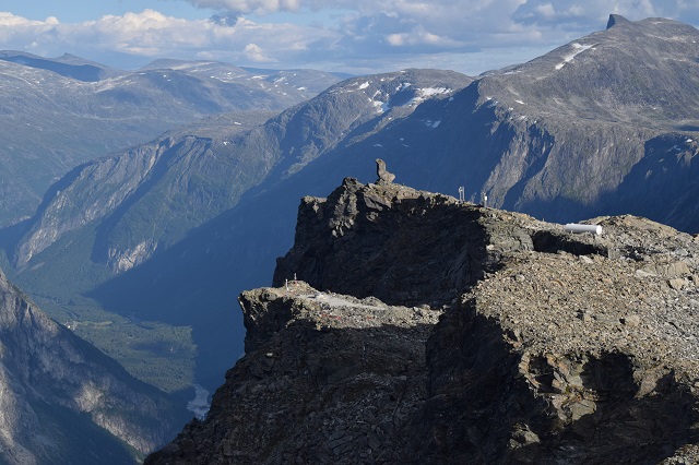
Photo 1: Top of Mannen mountain, with the name giving rock formation above the 20 m high backscarp of a c. 5 million cubic metre rockslide.
.
Extensive rockslide deposits in the valley, more than 1200 m below the top of the unstable rock mass, have been mapped within a recently published study in The Holocene (Hilger et al. 2018). These deposits point to a high rate of pre-historical rock-slope failure activity from this slope (Photo 2 and Fig. 1). The deposits from six to nine catastrophic rock-slope failures have been dated based on Quaternary geological mapping, stratigraphical geophysical analyses and terrestrial cosmogenic nuclide (TCN) dating.
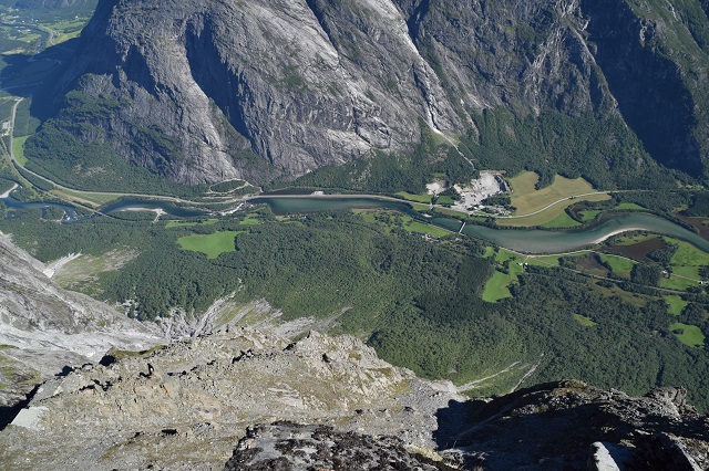
Photo 2: View from the top surface of the rock-slope instability down into the valley. The forest hides chaotic boulder fields of deposits representing 6-9 pre-historical catastrophic rock-slope failure events.
.
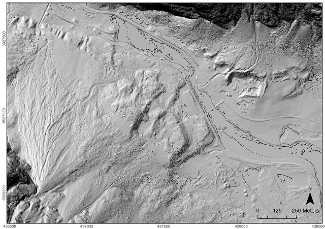
Figure 1: Hillshade of high-resolution (1m) LiDAR data of the valley floor below Mannen (cf. Photo 2). The morphology of several rock-slope failure deposits and some erosional features are well visible.
.
The results suggest Mannen has experienced two periods of ‘stability crises’ with multiple catastrophic rock-slope failure events from the same slope. Three events (numbers 1-3, Fig. 2) occurred within a time span of 2000 years between local deglaciation (12 ka) and the sea-level drop below the elevation of the valley floor below Mannen (10 ka). This fits well with a previously observed peak of rock-slope failure activity introduced by debuttressing and paraglacial stress release, closely following deglaciation.
A second stability crisis with at least three catastrophic rock-slope failures (numbers 4-6, Fig. 2) was dated by 11 TCN samples with indistinguishable ages within their 1σ uncertainty. Considering MANN-26 as an outlier, the mean ages of the events 4, 5 and 6 are 4.93 ± 0.30 ka, 4.96 ± 0.33 ka and 4.94 ± 0.31 ka, respectively. The results suggest that after the Holocene thermal optimum, about 5000 years ago, several clearly distinguishable rockslides failed within less than 200 years. A similar scenario in Loen, western Norway, killed 74 people in total, when the same slope failed up to seven times between 1905 and 1950, causing disastrous displacement waves in 1905 and 1936.
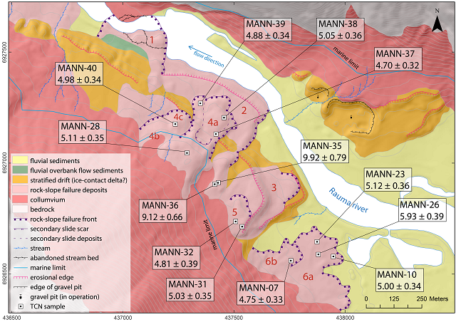
Figure 2: Quaternary geological map of the valley floor below Mannen with the locations and results of 13 samples analysed for the terrestrial cosmogenic nuclide 10Be. The map shows the same extent as Fig. 1.
The timing of the mid-Holocene stability crisis at Mannen suggests that climatic components were the major driving factors destabilising the rock slope, additionally to the structural geological preconditions. It coincides with a period of increased water availability (precipitation and snow melt), that most likely destabilised the highly fractured rock slope at a time of minimum permafrost distribution.
Today, the top of Mannen lies at the lower boundary of the regional permafrost distribution. What may happen next is difficult to predict. However, considering that this slope has engaged in a period of rumbling twice, both during or after periods with increasing temperatures, we should pay attention. Another aggravation for Mannen is the increased frequency and volume of precipitation and higher volumes of snow melt.
Is Mannen approaching a third stability crisis?
Acknowledgements
This study is part of a PhD project by Paula Hilger (UiO, NGU) with supervision of Reginald L. Hermanns (NGU, NTNU), Bernd Etzelmüller (UiO) and John C. Gosse (Dalhousie University, Halifax). The over-arching CryoWALL project is financed by the Research Council of Norway to the University of Oslo, NGU, the Technical University of Munich and the Norwegian public roads administration.
Reference
Hilger, P., Hermanns, R. L., Gosse, J. C., Jacobs, B., Etzelmüller, B., & Krautblatter, M. (2018). Multiple rock-slope failures from Mannen in Romsdal Valley, western Norway, revealed from Quaternary geological mapping and 10Be exposure dating. The Holocene. https://doi.org/10.1177/0959683618798165
 Dave Petley is the Vice-Chancellor of the University of Hull in the United Kingdom. His blog provides commentary and analysis of landslide events occurring worldwide, including the landslides themselves, latest research, and conferences and meetings.
Recent Comments