
22 February 2019
Longjing village: successful prediction of a significant rockslide
Longjing village: successful prediction of a significant rockslide
On 17th February 2019 a significant and potentially hazardous rockslide occurred in Longjing village, in Xingyi, Guizhou province, Southwest China. This landslide, which is formed primarily from dolomite, had a volume of about 1.4 million cubic metres. The landslide is shown below:-
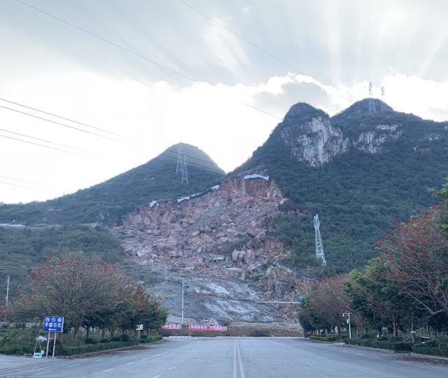
The Longjing village landslide in Guizhou village, China. Image via SKLGP.
.
This landslide was initially triggered in 2013 by cutting of the toe of the slope during road construction . The image below shows the state of the slope before the February 2019 landslide:-
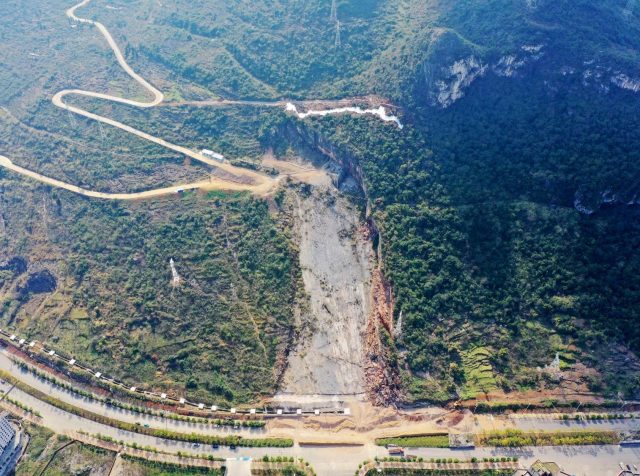
The Longjing village landslide prior to the February 2019 failure. Image via SKLGP.
.
The image shows a 270 metre long sliding surface with a steep scarp at the crown. It is unsurprising that there was potential further instability in this area, and the sliding surface clearly meant that the debris could impact the road. Investigations by SKLGP suggested that movement was facilitated on a 2 to 5 cm thick layer of clay between the dolomite bands, a situation that is often hazardous.
On June 2018 a 0.9 m wide tension crack was observed above the existing landslide crown, suggesting that further instability was developing. Over the next few months further deformation was observed. The local government worked with Professor Nengpan Ju and Professor Qiang Xu from SKLGP to install a real-time monitoring system on the landslide. This system is based on the analysis of patterns of deformation of the landslide (see Xu et al. 2017), and in particular it uses artificial intelligence to identify accelerating trends in movement data, sending an alert message when key thresholds were met. In this case, the system identified such a trend over the day preceding the landslide, issuing a “caution” (yellow) warning on 13th February and a “vigilance” (orange) warning on 15th February. Early in the morning on 17th February 2019 a red alert was issued, allowing 400 people from the area around the slope to be evacuated. The slope failed later that day.
The image below shows the movement record of the landslide:-
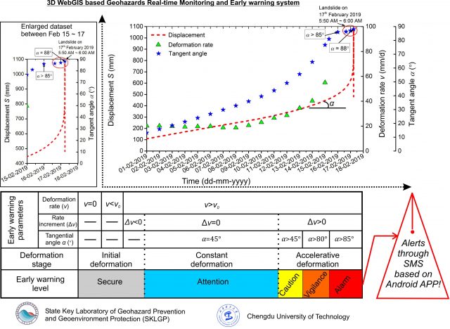
The movement record of the Longjin landslide as it accelerated to failure. Data provided by SKLGP, used with permission.
.
In the main graph the green triangles show the displacement of a sensor on the landslide with time, showing the characteristic hyperbolic acceleration to failure. The blue stars represent the analytical approach used to trigger the alerts, which are shown in the bar chart at the foot of the image.
This is not the first time that this system has been successfully deployed. In 2017 SKLGP report that it was used to predict the failure of two loess landslides in Gansu province, at Heifangtai in Yongjing County.
The development of warning systems for landslides continues to be a challenging but exciting area, and there is little doubt that in certain circumstances they can be a useful tool. In this case the system has played a major role in increasing public safety, which is very welcome.
Reference
Xing Zhu, Qiang Xu, Xing Qi, Hanxiang Liu. 2017. A Self-adaptive Data Acquisition Technique and Its Application in Landslide Monitoring. In WLF 2017: Advancing Culture of Living with Landslides pp 71-78. https://link.springer.com/chapter/10.1007%2F978-3-319-53487-9_7
Acknowledgement
Thanks to Professor Xuanmei Fan at SKLGP, Chengdu University of Technology, for providing information and the images that are the basis for this post.
19 February 2019
New on EarthArXiv: a first analysis of the flank failure of the Anak Krakatau volcano
New on EarthArXiv: a first analysis of the flank failure of the Anak Krakatau volcano
A paper has recently been posted to the open source repository EarthArXiv that provides a first analysis of the flank failure of Anak Krakatau volcano on 22 December 2018, which generated a tsunami that killed 431 people. The paper, Williams et al. (2019), uses a combination of remote sensing and eyewitness accounts to examine the sequence of events that generated the tsunami. Regular readers of the blog will remember that at the time it was quite difficult to untangle the sequence as volcanic eruptions before and after the collapse changed the topography quickly.
Williams et al. (2019) provide a particularly interesting perspective on the radar imagery collected over that period. Interestingly there is an animation of the radar sequence on Youtube, which also includes some initial interferometric analysis by reader funkenbeachin. InSAR is very difficult in a massif that has undergone so much change, but the radar sequence is very revealing:-
.
Williams et al. (2019) note that Sentinel-1A captured an image about 8 hours after the initial collapse event. This is shown in Panel C in the image from the paper below:-
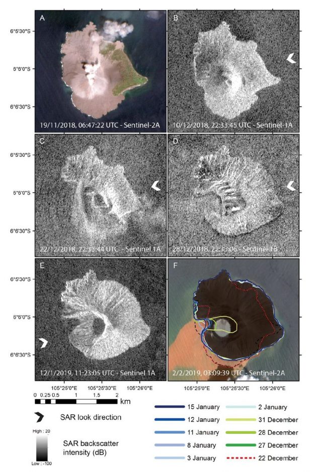
Satellite imagery of the series of events before and after the flank collapse at Anak Krakatau on 22 December 2018. Imagery from Sentinel-1A and Sentinel-2A
.
Williams et al. (2019) propose that the initial failure event consisted of an approximately 100 million cubic metre submarine failure, with a comparatively small (4 million cubic metre) terrestrial component. They suggest that the main part of the flank collapsed completely to generate the tsunami, with a smaller block, higher on the island, partially failing in a rotational manner to generate the approximately north-south orientated plane visible in the imagery. The failure decompressed the plumbing of the volcano to allow a new magma pathway to open, allowing the subsequent eruptive activity.
I am intrigued by the fate of this smaller partially failed block – if I was a referee I would want this to be considered more directly. This block does not appear in image D above, suggesting that it has failed in a second event. Did this occur in one movement or was it eroded away during the subsequent eruptive activity? The question of sequencing of flank failures is really important to understand likely tsunami generation, so this feels like a key issue.
Perhaps the most important part of this paper is this section:-
“We show that the flank failure was unexceptional, meaning that an extraordinary event was not required to trigger the tsunami, yet it had catastrophic consequences…The volume of the flank failure was small, compared to predicted collapse volumes and flank collapses at 25 other volcanoes, yet it generated a tsunami as large as and faster than modelled with a significantly larger collapse…this study also highlights that existing hazard assessments at volcanic islands are very likely underestimating the risks from volcanogenic tsunamis due to small (<0.25 km³) failures.”
That feels to me to be a very important set of conclusions from a very interesting and useful initial analysis.
Reference
Williams, R., Rowley, P., & Garthwaite, M. C. 2019. Reconstructing the Anak Krakatau flank collapse that caused the December 2018 Indonesian tsunami. EarthArXiv. https://doi.org/10.31223/osf.io/u965c
18 February 2019
The giant Daguangbao landslide: superheated steam and hot carbon dioxide
The giant Daguangbao landslide: superheated steam and hot carbon dioxide
It has long been known that extremely large landslides are able to travel surprisingly large distances – a phenomenon sometimes known as hyper-mobility – which implies that there must be very low levels of friction operating at the base of slide. Numerous methods have been proposed to account for this behaviour, but trying to gain evidence to support them or refute them is challenging.
The largest non-volcanic, terrestrial rockslide in recent years was the huge Daguangbao landslide, triggered by the 2008 Wenchuan earthquake. This is a true giant, with a volume of just over a cubic kilometre, which moved over a distance of about 3 km, as shown in the Google Earth image below:-
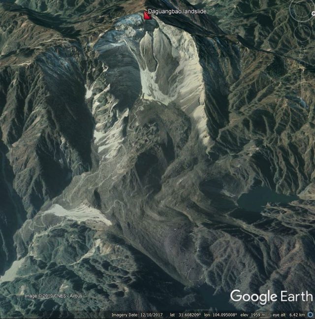
Google Earth image of the Dagunagbao landslide. The label marks the crown of the rear scarp of the landslide. The bare rock in the source area is also clear, as is the huge debris deposit.
.
The mechanisms of this complex event, and in particular the processes that occurred in the basal region during its movement, are extensively explored in a new paper just published in the journal Earth and Planetary Science Letters (Hu et al. 2019). The cross section from the paper, shown below, illustrates the extraordinary scale of the landslide:-
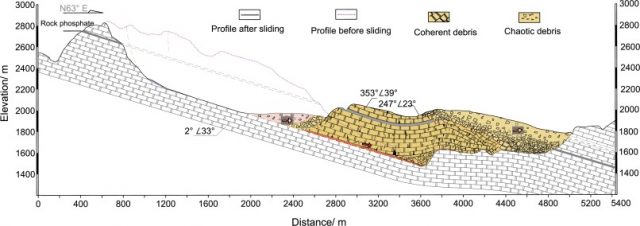
The geological cross section of the Daguangbao landslide. Diagram from Hu et al. (2019).
.
The statistics of this landslide are remarkable – for example, the debris in the deposit area is, in places, 500 m thick. This landslide would undoubtedly have traveled a great deal further had the topography allowed.
Hu et al. (2019) used a rotary shear machine to explore the processes operating at the base of the landslide as it moved. Samples of the basal dolomite were sheared at rates similar to those in the slide, and the strength was measured. The samples were then chemically and physically analysed to see if changes had occurred as a result of the deformation. During shearing,the resistance of the basal surface was found to drop as the rate of shearing increased. This is a neat self-reinforcing mechanism, which has been seen before. Basically, the earthquake initiated sliding and, as the landslide accelerated the friction in the base dropped, allowing the slide to accelerate further, which in turn further reduced the friction. That such a mechanism was operating is no great surprise.
But what is interesting here is that two processes were operating simultaneously to generate this very low friction. In both cases these are associated the very high temperatures caused by the shearing under such high pressure conditions. These were found to exceed 800°C, at which point carbon dioxide started to be released by the shear zone rocks as they decomposed under the high temperatures. This carbon dioxide coated the shear surface in a supercritical fluid (and there would have been superheated steam present too), which in effect increased the pore fluid pressure, reducing the friction.
Analysis of the rocks after the experiments found evidence for the decomposition of the dolomite rocks (described above), but also of dynamic recrystallization, which provides the second mechanism. This dynamic recrystallization formed a very thin layer on the shear surface, just o.1 mm thick, whose viscous resistance was found to be very low. As such, this dynamically recrystallized layer would have generated very low frictional resistance.
So, in the case of the Daguangbao landslide, two process operating in tandem generated the rapid drop in friction that gave this huge mass of rock the ability to travel at high speeds. Such mechanisms can only operate in very thick slides, and thus do not explain the hyper-mobility seen in other cases.
But this study shows that the behaviour of a 2 billion tonne landslide might have been controlled by a layer that is just 0.1 mm thick, which seems remarkable.
Reference
Hu,W., Huang, R., McSaveney, M., Yao, L., Xu, Q., Feng, M. and Zhang, X. 2019. Superheated steam, hot CO2 and dynamic recrystallization from frictional heat jointly lubricated a giant landslide: Field and experimental evidence. Earth and Planetary Science Letters, 510, 85-93. https://doi.org/10.1016/j.epsl.2019.01.005.
15 February 2019
Sausalito: a mudslide damages houses in California
Sausalito: a mudslide damages houses in California
Heavy rain in California, brought by an atmospheric river event, triggered a significant mudslide in Sausalito yesterday. ABC7 News has a report on the incident:-
“At least 50 homes remain evacuated after a massive mudslide struck a neighborhood in Sausalito on Crescent Avenue and Sausalito Boulevard. One of the homes on Crescent Avenue slid into a home on Sausalito Boulevard. A woman was inside the home that slid. She was taken to the hospital and has been released. The other home was not occupied at the time. When firefighters first arrived they evacuated the 50 homes over concerns that the hill could continue to give. Officials were also concerned that a gas line had ruptured and power lines were down.”
The image below shows the aftermath of the landslide. In Hong Kong the initial event would be classed as an open hillslope failure, with the debris transitioning into a channelised flow. There are reports that this slope has suffered failures previously:-
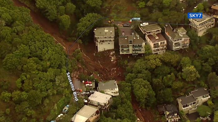
The aftermath of the mudslide in Sausalito on 14th February 2019. Image from ABC7 News.
.
ABC7 News also has a drone video of the aftermath of the landslide. The site of the mudslide in Sausalito is shown in the Google Earth image below:-
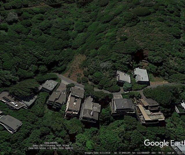
Google Earth imagery of the site of the mudslide in Sausalito on 14th February 2019
.
Note the smaller landslide scar above the road; this was not the site of the failure on this occasion.
The steeper slopes of California have a long track record of landslides, resulting from the combination of the topography built from active tectonic processes, the geological materials and the occurrence of both heavy rainfall events and earthquakes. It remains a surprise to see the number of houses that are built in geomorphologically-active areas, such as channels. It is unsurprising that there is frequent landslide damage in these areas during heavy rainfall.
13 February 2019
Pre-failure movement analysis of the Su Village (Sucun) landslide in China
Pre-failure movement analysis of the Su Village (Sucun) landslide in China
Back in April 2018 I wrote about an analysis of the Su Village (also known as Sucun) landslide in Zhejiang Province, China in 2016. This landslide, which was caught on video, killed 27 people. The analysis in Landslides published last year (Ouyang et al. 2018) indicated that some pre-failure deformation of the landslide had been detected. A new paper, also published in Landslides (Ouyang et al. 2019), examines this aspect of the landslide in more detail, considering in particular the degree to which pre-failure deformation could be detected using satellite imagery.
The paper includes the image below of the landslide, showing clearly the source zone for the failure (marked with the green arrows), the landslide track (yellow) and the deposition zone (in green again). The area in which the landslide impacted upon the village can be seen in the lower left corner of the image:-
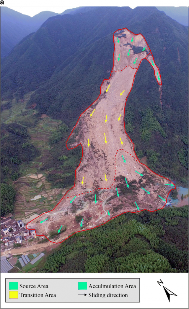
Annotated sketch of the Su Village (Sucun) landslide in Zhejiang Province, China. Image from Ouyang et al. (2019).
.
The authors used Sentinel-1A SAR (radar) imagery to investigate pre-failure deformation of the Su Village landslide, based upon an analysis of the 36 images using Persistent Scatterer Interferometry. The image below shows the points that were analysed across the landslide and its adjacent slopes, with the colours indicating the magnitude of the movement detected:-
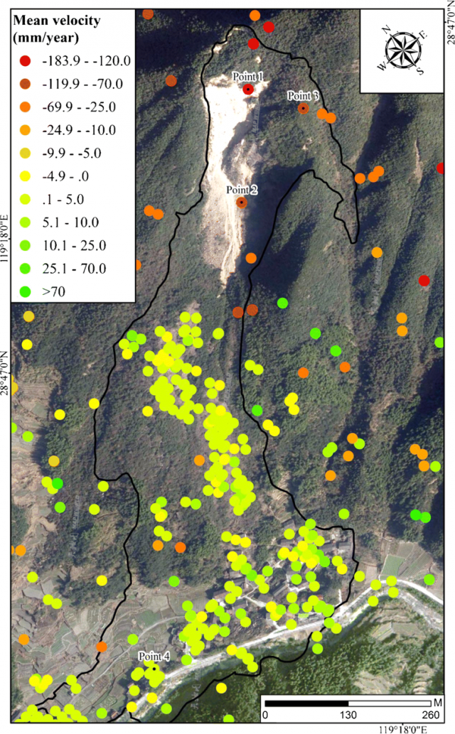
Analysis of the pre-failure deformation of the Su Village (Sucun) landslide using PSI. Image from Ouyang et al. (2019).
.
My interpretation of the is that the yellow and green dots show no movement beyond error in the technique, whereas the orange and red dots show detectable deformation. The failure initiated in the source area shown in the first image, which then caused the rest of the slope to collapse, so it is reassuring that the detectable pre-failure deformation is situated high in the slope. The highest rates are in the section of the slope that collapsed, close to the crown of the landslide. But note also that significant deformation is seen in adjacent slopes that, at the time of analysis, had not failed. Thus, the InSAR results do not give a spatial indication of the likely form of the final failure (whilst also suggesting that there may be other hazardous areas on this slope).
The displacement – time series graph also shows the results of this analysis, based on the points shown in the image above:-
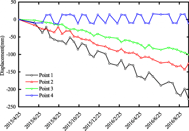
Time series analysis of the pre-failure deformation of the Su Village (Sucun) landslide using PSI. Graph from Ouyang et al. (2019).
.
There is a mixed picture here. The good news is that statistically significant movement was detected in the areas that failed, whilst the unfailed areas displayed no trend (with some noise). But the detected movement is linear with time in all three points with above-error deformation, meaning that no inferences could be drawn to indicate time of failure. Thus, whilst the analysis shows that the slope was creeping, it could not be used as a warning system.
This paper is another very useful contribution towards the use of InSAR data for rock slope failure detection in natural slopes. But, once again, it shows that this is a very complex and challenging problem, and that our satellite based systems do not yet have the maturity to be used operationally in many cases as yet.
References
Ouyang, C., Zhao, W., Xu, Q. et al. 2018. Failure mechanisms and characteristics of the 2016 catastrophic rockslide at Su village, Lishui, China. Landslides. https://doi.org/10.1007/s10346-018-0985-1
Ouyang, C., Zhao, W., An, H. et al. 2018. Early identification and dynamic processes of ridge-top rockslides: implications from the Su Village landslide in Suichang County, Zhejiang Province, China. Landslides. https://doi.org/10.1007/s10346-018-01128-w.
12 February 2019
Cuajone mine in Peru: reports of landslide damage, and a fatality, caused heavy rain
Cuajone mine in Peru: reports of landslide damage, and a fatality, caused heavy rain
Cuajone mine in Peru is a giant mine and smelter located at an elevation of 3,400 metres in the Andes. The mine, which uses open pit excavation to extract copper ore from an enormous deposit, is owned by Southern Copper. The Google Earth image below gives an idea of the scale of the mine:-
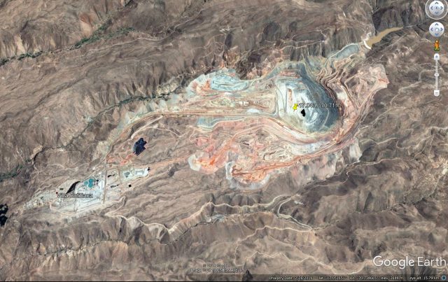
Google Earth image of the Cuajone mine in Peru.
.
This area of Peru has suffered unusual, very heavy, rainfall in the last few days. At least 10 people have been killed in various incidents, with mudslides and rockfalls being widely reported. Southern Copper has reported that production at Cuajone mine has been reduced for three to five days as a result of damage inflicted upon its infrastructure by the heavy rains. It is reported that a worker has been killed by a mudslide, reportedly in a ravine.
Whilst the picture is uncertain, there are various reports about fears that there has been a tailings failure at Cuajone mine. The basis of these reports appears to be observed contamination of the river downstream of Cuajone mine. This report is from CNBC:-
“Peru’s environmental regulator OEFA has been investigating a potential tailings spill at Southern Copper’s Cuajone mine, after being alerted by local residents of a “greenish solution” that started streaming into a nearby river.”
Whilst Southern Copper denies that there has been a tailings spill, this event is being taken sufficiently seriously that OEFA have a statement on their website confirming that it is being investigated. At present this does not appear to be a tailings dam failure, and there is no obvious signs of this type of event on the satellite imagery of the last few days. However, these reports of landslides at Cuajone mine are likely to raise concerns about the management of tailings at large mine sites, and once again reiterates the problems that the mining industry is facing with safe slope management.
Meanwhile, there has been yet another mining related landslide in the Hpakant area of Myanmar, this time killing six people. This is the latest of the long and desperate recent history of jade mining landslides in Kachin state. The death toll in 2019 is already at least ten people, this will inevitably increase substantially in the months ahead.
11 February 2019
Hurricane Maria: a first analysis of landsliding in Puerto Rico
Hurricane Maria: a first analysis of landsliding in Puerto Rico
On 20 September 2017 Puerto Rico suffered a direct hit from Hurricane Maria, with tragic consequences. It was the strongest landfalling hurricane to strike Puerto Rico since 1928, with some estimates suggesting that the final death toll exceeded 4,000 people. Landslides were a major factor in the event; they are known to have caused at least three fatalities directly, whilst disruption to power infrastructure, in part caused by the mass movements, continued for months.
A paper published last month (Bessette-Kirton et al. (2019)) in GSA Today provides an analysis of the landslides distribution triggered by Hurricane Maria. Using post-event satellite imagery, the authors mapped the density of landslides triggered by the hurricane. They did not map individual landslides, but instead divided the island into a 2 x 2 km grid. For each grid cell they classified the landslide density based on a three-fold system (a: no landslides (NLS); b: 1–25 landslides/km² (low landslide density, LLD); or c. more than 25 landslides/km² (high landslide density, HLD)). The resulting landslide density map for Hurricane Maria is shown in the figure below:-
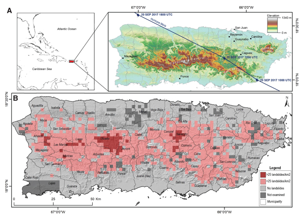
The landslide density for events triggered by Hurricane Maria in Puerto Rico, from Bessette-Kirton et al. (2019). Original caption: (A) Topographic map of Puerto Rico showing the storm track of Hurricane Maria. (B) Relative density of landslides mapped from the rapid classification of satellite and aerial imagery and site visits following Hurricane Maria.
.
In total, Bessette-Kirton et al. (2019) report that Hurricane Maria triggered over 40,000 landslides, a truly remarkable number. As the diagram above shows, these landslides were concentrated in the upland areas of Puerto Rico, with five distinct clusters of very high landslide occurrence. This level of landsliding is unprecedented in Puerto Rico.
Bessette-Kirton et al. (2019) have looked carefully at the contributing causes of the remarkable landslide impact of Hurricane Maria. They found a comparatively weak correlation with the rainfall record, but recognise that the data might be compromised by the failure of the island’s doppler radar system and many of the rain gauges. A better correlation was found with soil moisture, which they note probably gives a better indication of the pore water condition of the soil. The authors note that even prior to the landfall of Hurricane Maria soil moisture levels were unusually elevated, which might in part explain the very high landslide incidence during the storm. Interestingly, the authors did not find a good correlation between landslide density and either slope angle or bedrock geology, which is quite unusual.
The impact of Hurricane Maria has been devastating to Puerto Rico, and the national level response was shocking. This study usefully highlights the magnitude of the impacts of the storm, which will hopefully allow for better preparedness in the future.
Reference
Bessette-Kirton, E.K., Cerovski-Darriau, C., Schulz, W.H., Coe, J.A., Kean, J.W., Godt, J.W., Thomas, M.A. and Hughes, K.S. 2019. Landslides triggered by Hurricane Maria: assessment of an extreme event in Puerto Rico. GSA Today, 29, https://doi.org/10.1130/GSATG383A.1.
8 February 2019
Submarine landslides can creep too – my latest paper
Submarine landslides can creep too – my latest paper
In comparison with terrestrial mass movements, submarine landslides are surprisingly poorly investigated, despite the hazards that they pose in terms of tsunami generation and hazards to seafloor infrastructure. There is a body of literature on rapid, large failures, which are often catastrophic. However, many terrestrial landslides show creep or episodic movements without accelerating to rapid failure, so it is interesting to consider whether this can happen in submarine landslides too.
Working with colleagues from GNS Science and from NIWA, we have studied this problem in the context of a large submarine landslide complex offshore from New Zealand. The work has just been published in the journal Geomorphology. For a limited time (until 2nd March 2019) the full version of this paper (Carey et al. 2019) can be downloaded from the publisher, and there will also be a version in White Rose Research Online, which is is the open access repository for the University of Sheffield.
The submarine landslide that we have studied is the Tuaheni Landslide Complex, located in the Tuaheni Basin to the east of North Island in New Zealand. This is a spectacular submarine landslide. It covers an area of about 145 km² (which is about 40 km² greater than the area of the City of Manchester). The landslide, which is shown in the image below from Carey et al. (2019), displays features that suggest that it has already moved a considerable distance without failing catastrophically. There are however no movement records available.
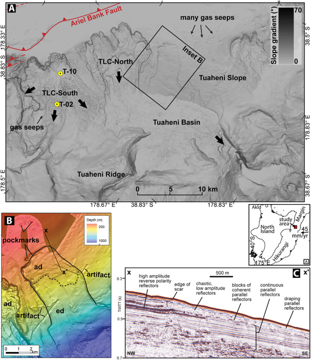
Details of the Tuaheni landslide complex, from Carey et al. (2019).
.
There has been speculation about the mechanisms through which slow movement can occur in this landslide, with one idea being that gas hydrates release methane that drives up the pore fluid pressure in the base of the landslide. The idea is that once movement initiates the sediment cannot retain the high gas pressures, dropping the pore water pressure and thus terminating the movement. Through this mechanism the slide can move episodically without moving into a rapid failure mode.
In this research we have taken samples that were retrieved from the landslide in 2014 during drilling by NIWA’s deep water research vessel, the RV Tangaroa. We tested these samples in the dynamic back pressured shearbox, which allows us to recreate the stress state in the landslide system, and then to run scenarios to see how the sediments respond. So, for example, we experimented with injecting gas (we use nitrogen not methane for safety reasons) into the simulated landslide to see whether we could invoke movement. Such experiments are great fun, allowing us to explore the range of possibilities that might control landslide movement from the comfort of the lab.
We found that increases in pore fluid pressure, initiated for example by increased gas pressures do indeed allow the landslide to start to move, as expected. We found that initially, as the sample starts to shear the pore fluid pressures increase, driving further movement. If this had continued unchecked the landslide would go into a rapid failure mode. But in this case, the sediments around the shear zone rapidly dilate, creating a wider zone of deformation that then dissipates higher the pore fluid pressures, and so the landslide stops moving. The system has now accumulated some displacement, but is stable, waiting for the next occasion in which pore fluid pressures increase, when the cycle repeats.
Thus, in this way, the Tuaheni landslide complex is able to undergo repeated small displacements, which over a long period of time allow large strains to develop. But, because larger movements mean that the cause of the movement (high pore fluid pressures) is lost, the landslide is never able to go into a rapid failure mode.
There is nothing special about the sediments in the Tuaheni landslide complex, so we conclude that creeping submarine landslides are entirely possible in similar settings.
Reference
Carey, J.M., Crutchley, G.J., Mountjoy, J.J., Petley, D.N., McSaveney, M.J. and Lyndsell, B. 2019. Slow episodic movement driven by elevated pore-fluid pressures in shallow subaqueous slopes. Geomorphology, 329, 99-107. https://doi.org/10.1016/j.geomorph.2018.12.034
7 February 2019
Cape Kidnappers: a succession of large rockslope failures in New Zealand
Cape Kidnappers: a succession of large rockslope failures in New Zealand
According to Wikipedia, the delightfully named Cape Kidnappers is “a headland at the southeastern extremity of Hawke’s Bay on the east coast of New Zealand’s North Island and sits at the end of an 8 km peninsula which protrudes into the Pacific Ocean.” This is a stunning site that is renowned for bird life, especially gannets. On 23rd January 2019 Cape Kinappers site suffered a large rockslope failure, seriously injuring two people. Reports suggest that the two victims were swept off the beach and into the sea – it must have been a terrifying experience.
There is some stunning imagery available of this large rockfall. Stuff has a lovely image of the deposit and the scar for example:-
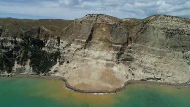
The aftermath of the first large rockslope failure at Cape Kidnappers on 23rd January 2019. Image via Stuff.
.
There is also some excellent images of the rockslope failure at Cape Kidnappers. Stuff has this online as a video, and Anusha Bradley tweeted a video of the rockfall happening:
Tourist Denis Birnie captured this video of the slip pic.twitter.com/1DfTaTsfUC
— Anusha Bradley (@AnushaBradley) January 23, 2019
On 2nd February 2019 a further large collapse event occurred, with another significant chunk of the slope detaching. As with the first collapse, the failure appears to be a on a face-parallel detachment surface. A large block remains on the slope to the left of the original collapse; this must now be vulnerable to a failure event, suggesting that there will be a significant hazard at this site for a while:-
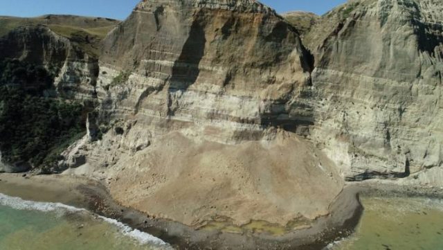
The aftermath of the second large rockslope failure at Cape Kidnappers on 2nd February 2019. Image via Stuff.
.
The geology of Cape Kidnappers consists of an alternating sequence of Middle Pleistocene shallow water sediments, primarily conglomerates and lignitic mudstones. These are weak rocks that are susceptible to weathering and undercutting (as can be seen on the right side of the images. Thus, significant rockslope failures are unsurprising. In many ways this event is similar to the chalk rockfalls seen on the southern coast of the UK.
5 February 2019
Cobre Las Cruces, Spain: another massive mining landslide
Cobre Las Cruces, Spain: another massive mining landslide
Whilst attention has been focused on the events at Brumadinho in Brazil, another massive mining-induced landslide occurred in Spain on 23rd January, this time at the Cobre Las Cruces mine. Manuel Jesús Florencio has an excellent article online about the failure (in Spanish). This is a very big event, with an estimated volume in the order of 15 million cubic metres (i.e. considerably larger than the landslide at Brumadinho). Fortunately, there were no casualties.
Manuel Jesús Florencio’s article includes this image of the aftermath of the landslide:-
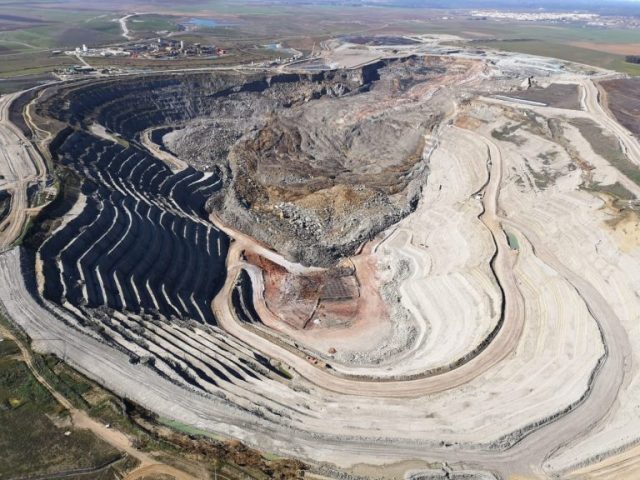
The 15 million cubic metre landslide at Las Cruces mine in Spain. Image via Manuel Jesús Florencio.
.
A very substantial section of the northwest corner of the mine has collapsed to generate a landslide about 1.3 km in length. You can get a sense of the scale of the landslide by comparing the Google Earth image of the mine prior to failure (this image was collected in June 2016):
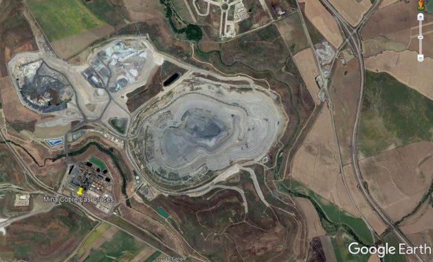
Google Earth imagery of the Cobre Las Cruces mine in Spain, collected in June 2018 prior to the major failure. Image via Manuel Jesús Florencio.
.
With the Planet Labs image of the site after the landslides (this is a Planetscope four band image):-
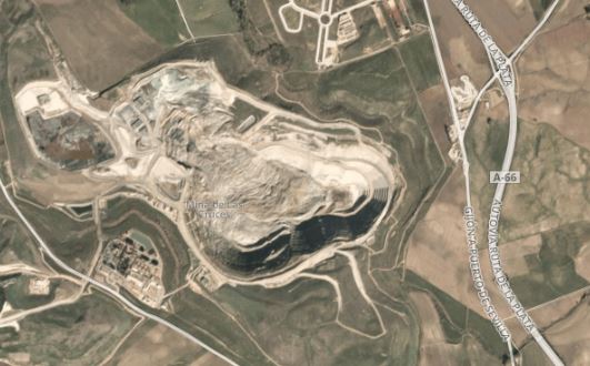
Planet Labs image of the aftermath of the Cobre Las Cruces mine landslide. Planet Labs image collected 4th February 2019. Copyright Planet Labs, used with permission.
.
This is a closer view of the landslide:-
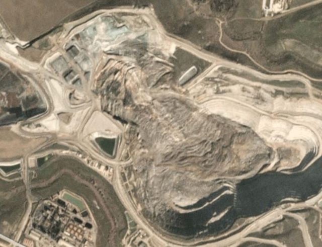
Planet Labs image of the aftermath of the Cobre Las Cruces mine landslide. Planet Labs image collected 25th January 2019. Copyright Planet Labs, used with permission.
.
Geotecniafacil.com has a nice article (again in Spanish) about the background to this landslide. It notes that Cobre Las Cruces is the largest open case copper mine in Europe, but that the core deposit is overlain by blue marls that cause may geotechnical problems. It notes that once weathered these materials are extremely weak, with no cohesion and a very low effective friction angle. This is consistent with the failure seen in the images, which seems to have retrogressed a large distance into the slope, implying a low shear plane angle.
Production is expected to be halted for six months, suggesting that this will be an exceptionally expensive event.
Meanwhile, at least 17 people were killed in a landslide in a gold mine at Norassoba in Guinea on Sunday.
Acknowledgement and reference
Thanks to Carlos Jimémez and Joan Rossello for highlighting this event to me.
Planet Team (2019). Planet Application Program Interface: In Space for Life on Earth. San Francisco, CA. https://www.planet.com
 Dave Petley is the Vice-Chancellor of the University of Hull in the United Kingdom. His blog provides commentary and analysis of landslide events occurring worldwide, including the landslides themselves, latest research, and conferences and meetings.
Recent Comments