11 February 2019
Hurricane Maria: a first analysis of landsliding in Puerto Rico
Posted by Dave Petley
Hurricane Maria: a first analysis of landsliding in Puerto Rico
On 20 September 2017 Puerto Rico suffered a direct hit from Hurricane Maria, with tragic consequences. It was the strongest landfalling hurricane to strike Puerto Rico since 1928, with some estimates suggesting that the final death toll exceeded 4,000 people. Landslides were a major factor in the event; they are known to have caused at least three fatalities directly, whilst disruption to power infrastructure, in part caused by the mass movements, continued for months.
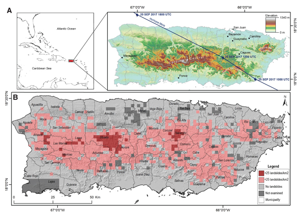
A paper published last month (Bessette-Kirton et al. (2019)) in GSA Today provides an analysis of the landslides distribution triggered by Hurricane Maria. Using post-event satellite imagery, the authors mapped the density of landslides triggered by the hurricane. They did not map individual landslides, but instead divided the island into a 2 x 2 km grid. For each grid cell they classified the landslide density based on a three-fold system (a: no landslides (NLS); b: 1–25 landslides/km² (low landslide density, LLD); or c. more than 25 landslides/km² (high landslide density, HLD)). The resulting landslide density map for Hurricane Maria is shown in the figure below:-

The landslide density for events triggered by Hurricane Maria in Puerto Rico, from Bessette-Kirton et al. (2019). Original caption: (A) Topographic map of Puerto Rico showing the storm track of Hurricane Maria. (B) Relative density of landslides mapped from the rapid classification of satellite and aerial imagery and site visits following Hurricane Maria.
.
In total, Bessette-Kirton et al. (2019) report that Hurricane Maria triggered over 40,000 landslides, a truly remarkable number. As the diagram above shows, these landslides were concentrated in the upland areas of Puerto Rico, with five distinct clusters of very high landslide occurrence. This level of landsliding is unprecedented in Puerto Rico.
Bessette-Kirton et al. (2019) have looked carefully at the contributing causes of the remarkable landslide impact of Hurricane Maria. They found a comparatively weak correlation with the rainfall record, but recognise that the data might be compromised by the failure of the island’s doppler radar system and many of the rain gauges. A better correlation was found with soil moisture, which they note probably gives a better indication of the pore water condition of the soil. The authors note that even prior to the landfall of Hurricane Maria soil moisture levels were unusually elevated, which might in part explain the very high landslide incidence during the storm. Interestingly, the authors did not find a good correlation between landslide density and either slope angle or bedrock geology, which is quite unusual.
The impact of Hurricane Maria has been devastating to Puerto Rico, and the national level response was shocking. This study usefully highlights the magnitude of the impacts of the storm, which will hopefully allow for better preparedness in the future.
Reference
Bessette-Kirton, E.K., Cerovski-Darriau, C., Schulz, W.H., Coe, J.A., Kean, J.W., Godt, J.W., Thomas, M.A. and Hughes, K.S. 2019. Landslides triggered by Hurricane Maria: assessment of an extreme event in Puerto Rico. GSA Today, 29, https://doi.org/10.1130/GSATG383A.1.


 Dave Petley is the Vice-Chancellor of the University of Hull in the United Kingdom. His blog provides commentary and analysis of landslide events occurring worldwide, including the landslides themselves, latest research, and conferences and meetings.
was deforestation etc calculated in as a possible exacerbating factor?
Before, a huragans of such scale was a rarity and a really serious problem.They weren’t frequent. At this time,they are kind of normal. I think, we should stop and think about what’s happening on our planet. In the program “[link removed by DP] , this topic is well expanded on, we just need to call attention to this problem and think about what’s going to happen next…
[I agree that we should stop and think about our planet, but the link was to pseudoscientific nonsense. D]