
26 December 2018
The Anak Krakatau landslide and tsunami
Posted by Dave Petley
The Anak Krakatau landslide and tsunami
The disastrous and tragic landslide and tsunami from Anak Krakatau (Anak Krakatoa) has rightly dominated the news over the Christmas break. At least 429 people are known to have been killed, making this one of the worst landslide-induced disasters of the year, with a further 154 people thought to be missing. Severe weather, and in particular heavy rainfall, is making both the assessment of events to date and in the assessment of what might come next extremely challenging. Further landslides cannot be ruled out.
We can say with some certainty that the tsunami was triggered by a landslide from Anak Krakatau. There are two strong pieces of evidence for this. First, whilst it has not been possible to obtain visual satellite imagery of the island because of the weather, radar data (which is not obscured by cloud) has been available. The ESA Sentinel-1 satellite collected a decent image on 22nd December:-
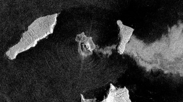
European Space Agency Sentinel-1 image dated 22nd December 2018 showing the deformation of Anak Krakatau. Copyright ESA, image accessed via Sentinel Hub.
.
This is a remarkable image, showing amongst other things the volcanic plume being blown to the east and the radial waves from the island being generated by the ongoing eruptions. But most importantly it shows what appears to be a large scarp to the west of the volcano cone, presumably marking a large-scale deformation (landslide) of the volcanic edifice of Anak Krakatau. There would have been a large submarine element to this, which presumably generated the tsunami.
Secondly, a strong seismic signal was generated by the landslide, which was detected on a number of seismometers. Jamie Gurney (@UKEQ_Bulletin) has done a great job of collating that information via Twitter. The seismic signal has a very strong low frequency component, characteristic of a landslide-induced, rather than a tectonic, event.
The challenge now is to interpret what might be happening on the volcano, and what might happen next. The latest Sentinel-1 image does not help:-
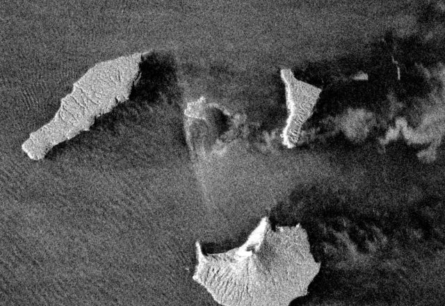
European Space Agency Sentinel-1 image dated 25th December 2018 showing the deformation of Anak Krakatau. Copyright ESA, image accessed via Sentinel Hub.
.
I am no expert on radar imagery, and others may be able to provide more information about what this shows. It seems to me that a large part of the island appears to be generating very little useful data – is this because of a drape of new deposits from the eruptions of the last few days? The upshot is, I think, that we cannot really interpret whether the volcano is deforming (or has deformed) further.
Quite rightly, the authorities are concerned about further landslides, but the only advice at this point is to stay away from the coast and to be vigilant.
Volcanic flank collapses are a well-known hazard, and the potential for the collapse of Anak Krakatau has been highlighted previously. These landslides have huge destructive potential but are inadequately researched when compared to many other hazards.
 Dave Petley is the Vice-Chancellor of the University of Hull in the United Kingdom. His blog provides commentary and analysis of landslide events occurring worldwide, including the landslides themselves, latest research, and conferences and meetings.
Yes
Dear colleagues,
In order to complement this excellent post, the extent of the massive flank collapse can be inferred using a composite of Sentinel-1 images before and after the eruption, feel free to have a look here: https://mobile.twitter.com/cggnpa/status/1077160290867953664?s=21
(Credit: NPA SatelliteMapping)
Best regards,
A.
Google Earth suggests that the water depth on the western side of the volcano is shallow, in the order of a few metres deep. In fact the whole area inside the caldera is quite shallow. And the caldera itself is located in the relatively shallow strait.
If a large portion of the western flank has slumped then one might expect the volcano’s above sea level area to have increased with the toe running into the shallows, no?
A slide running into shallow water is very likely to generate a series large surface waves which could be quite destructive when they reach opposite shores. Such a scenario could also account for the lack of recorded seismic signal, in my opinion of course. In addition some eyewitnesses report that there was no retreat of water before the waves hit.
A clearer radar image:
http://www.gsi.go.jp/cais/topic181225-index-e.html
A scary-clear radar image has just been on BBC TV news headlines, looks like Western 2/3 of island ‘took a dive’.
These are a bit fuzzier…
https://www.bbc.co.uk/news/science-environment-46707731
Note they DO mention this potential flank collapse was modelled and reported in 2012…
IMHO, the resulting cliffs appear dangerously unstable.
Now waiting for eruption to ease, allow better assessment of wrack…
Very interesting photos. The image showing the radial waves is really incredible. I’ve never seen anything like that before and didn’t know satellites even had the capability to capture an image like that. Hopefully it will lead to a greater understanding of the potential danger associated with landslide induced tsunamis and save lives in the future.