1 November 2021
A large landslide or glacial lake outburst in the headwaters of the Kameng River in Northern India?
Posted by Dave Petley
A large landslide or glacial lake outburst in the headwaters of the Kameng River in Northern India?
Loyal reader Robert Wasson has very kindly highlighted an interesting article in the Discovering Arunachal blog, posted on Saturday. This article observes that at about 10:30 am on 29 October 2021 the Kameng River in East Kameng district in Arunachal Pradesh in northern India became extremely muddy. News reports indicate that the measured dissolved solids increased by about five fold and there was a mass die off of the fish population in the river.
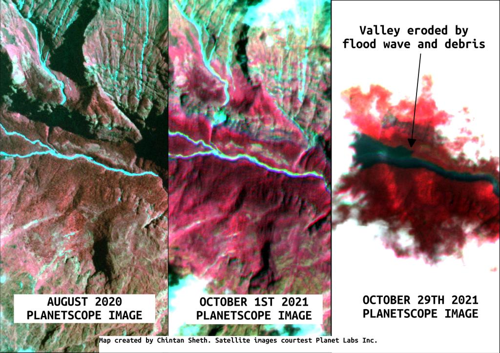
Chintan Sheth, the author of the Discovering Arunachal blog, has used satellite images to try to discover what caused this unexpected event. The upstream area, along the banks of the Warriyang Bung river, is almost permanently covered in cloud at this time of the year, but on 29 October 2021 Planet Labs captured an image of part of the Warriyang Bung river catchment, from which Chintan Seth has created an image of the impact of the event:-

A composite set of Planet Labs images showing the change in the visible section of channel on the Warriyang Bung river in northern India. Image compiled by Chintan Sheth and published on the Discovering Arunachal blog.
.
The location of the site is 27.877, 92.702. The images appear to show that there has been heavy erosion and deposition along the river. Unfortunately the source of this event is under thick cloud.
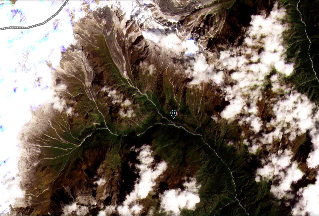
Back on 1 October 2021 Planet Labs captured a beautiful image of the catchment:

The catchment of the Kameng River that was the source of the event of 29 October 2021. Image copyright Planet Labs, used with permission, captured on 1 October 2021.
.
This is a complex catchment, with small glaciers and steep slopes. I cannot see any obvious glacial lakes, but these could be obscured by clouds. The most three obvious candidates for this event are the collapse of a glacial lake, a the collapse of a glacier or a rock slope collapse. The latter seems more likely, but we may not know until a cloud free image with low levels of snow becomes available. That might not be the case until the spring.
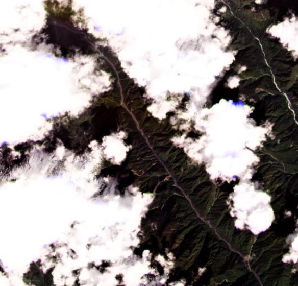
Imagery of the channel downstream shows erosion and deposition along the channel, suggesting that this was a significant event.

The upper catchment of the Kameng River showing changes to the channel following the event of 29 October 2021. Image copyright Planet Labs, used with permission, captured on 29 October 2021.
.
Reference
Planet Team (2021). Planet Application Program Interface: In Space for Life on Earth. San Francisco, CA. https://www.planet.com/


 Dave Petley is the Vice-Chancellor of the University of Hull in the United Kingdom. His blog provides commentary and analysis of landslide events occurring worldwide, including the landslides themselves, latest research, and conferences and meetings.
Response to.. Why is the Kameng river muddy ? Oct. 2021:
Thanks for the evaluation of this event. I did a quick check using Google maps. Wow. The glacier and landscape features above the location you describe , on the north side of the Warriyang Bung river look heavily incised from past major floods and progressive retreat of the glacier in a cradle-like perched steep basin, lots of stagnant ice at the terminus, and heavily crevassed regions above the terminus. The recent very intense convective precipitation events along back building moisture plumes forming ahead of unseasonably strong strong cold fronts, that tapped into the monsoonal/tropical moisture from the Indian Ocean could well have led to very heavy precipitation on southwesterly facing slopes. The converging upslope flow of warm moist conveyor jets/atmospheric river plumes just ahead of slow moving cold fronts that were evident near this time and earlier (at least farther west), could have enhanced precipitation rates many times the surrounding regions. Heavy precipitation and rapid snow melt in a perched valley with a swly aspect is a dangerous mixture in such glaciated steep mountain areas… If snow levels fluctuated, with heavy snow, then heavy rain and high snow levels at times, well you have could quickly create quite a calamity if the water gets pooled and then outbursts, or the drainage networks in the glacier get clogged with debris and release water, or drainage systems are damaged by a temporarily accelerating glacier sliding faster due to all the water at the bed, and higher water pressures and then release a flood as per surging glaciers. OR simply a perched lake formed and was dammed by a big tributary landslide slide and then released. There is widespread evidence of smaller landslides, any of which could dam a tributary… Many possibilities, but in the region you show the glacier just NW of the tributary V of you evidence of a landslide/debris flow/flood, this area appears to me primed to create a glacier related flooding event with the recent storms encountered in October. Similar atmospheric river related heavy precipitation events/ with rapidly varying snow levels occurred as we had several major landslides in BC and nearby areas of Alaska last winter (Haines Alaska/Pleasant Camp BC, and also Bute Inlet/Homathko Icefield BC area). The deeply incised proglacial landscape evidence speaks volumes to me that such damaging flood events have happened multiple times in the past, and it would make sense such locally catastrophic events still occur under certain circumstances even with a greatly dwindled glacier. There is plenty of glacial ice held especially on northerly shaded slopes, and at high elevations. Thanks for sharing this story.. Beautiful amazing and actively eroding India. Take care and I hope we get some views safely locally or from satellites to learn what has transpired, if further hazards exist, and to better know how to forecast these events.
Thanks, we wrote about this on Oct 31, mainly thanks to Chintan Sheth blog and media reports see: https://sandrp.in/2021/10/31/muddy-kameng-river-waters-mass-fish-death-in-oct-2021/
The fact that the downstream big river remained muddy at least five days after the first reports seems to indicate that this episode may have multiple incidents. Would like to know what your reading about this prolonged duration of muddy river so much downstream.
Himanshu Thakkar, SANDRP
Thanks for the reference. Regarding the prolonged occurrence of a muddy river downstream, that indicates that ongoing erosion and transportation of sediment is occurring, likely multiple places along the channel. If hte water levels are similar to the past, this suggest that there is insufficient vegetation to trap the sediment along the stream banks, and that there is quite a pulse of sediment working its way down stream, with reasonably high river flows. If a significant landslide occurred or debris deposited in the main channel, this high sediment flux could occur for a long time before it tails off. Highly sediment charged water is typical of the bed of glacial systems, but it will tail off as the higher elevations freeze up and the supply of water is reduced from the glaciers. To know for sure would take a careful study. If there is a landslide damming a portion of the valley, or a lake impoundment formed you should find evidence of that risk. My guess is there was so much sediment discharged into the river that its slowly being transported downstream, and recycled. I suggest track river discharge, sediment volume, sediment grain size, and conductivity at multiple locations downstream and also precipitation , and hope that you get some visibility in satellite imagery. A good tool would be SAR satellite radar interferometry to examine changes in the surface and movement. That can typically be done through clouds but the atmosphere will affect the result. Good luck.. With so much sediment transported the fish will have difficulties, but they find places to hide, and they can adapt. The good part is there will be many nutrients arrive with the sediment, so as long as people keep away from the flood hazard it may have some good points too. I hope you can share what you learn and have support to examine this further. Yes there can be more hazards once such events happen, but if it is related to a glacier outburst, well that may be the event for this year. However another could well happen with another big warm rain event late in the melt season in the future, especially with glacial systems that are so clogged with debris. The event may have nothing to do with the glaciers, but it seems that’s a likely blaringly risky situation in those headwaters. What a marvelous place in the world – but very wild where nature rules. I can tell it is well cherished..or hope so. Its a good place to apply your expertise and also ask the world to help in any way we can.
Dear Dr. Brugman
Can i please have your email id, we are trying to put together a team to analyse the cause of this event and its repercussions to the aquatic ecosystem. Your meteorological perspective and observations on this event seem to be quite nuanced and complicated and we would like to have you on board.
I have messaged you on Research Gate perhaps you can check there and share your email ID with me so I can share some of the data we have collected and chart a way ahead?
best wishes from the himalaya
chintan