
2 February 2022
The disastrous 31 January 2022 mudflow in the La Gasca suburb of Quito, Ecuador
Posted by Dave Petley
The disastrous 31 January 2022 mudflow in the La Gasca suburb of Quito, Ecuador
On 31 January 2022 heavy rainfall triggered a disastrous mudflow in the La Gasca suburb of Quito in Ecuador. There is a detailed set of articles about this event on the El Comercio news website. In an article posted yesterday it records the losses as 24 known fatalities, a further 12 people missing and 48 people injured. This is likely to be updated during the day today.
Extremely heavy, short duration rainfall (7.5 cm in one hour has been reported) was the trigger for the mudflow. The Google Earth image below shows the La Gasca suburb and the local topography:-
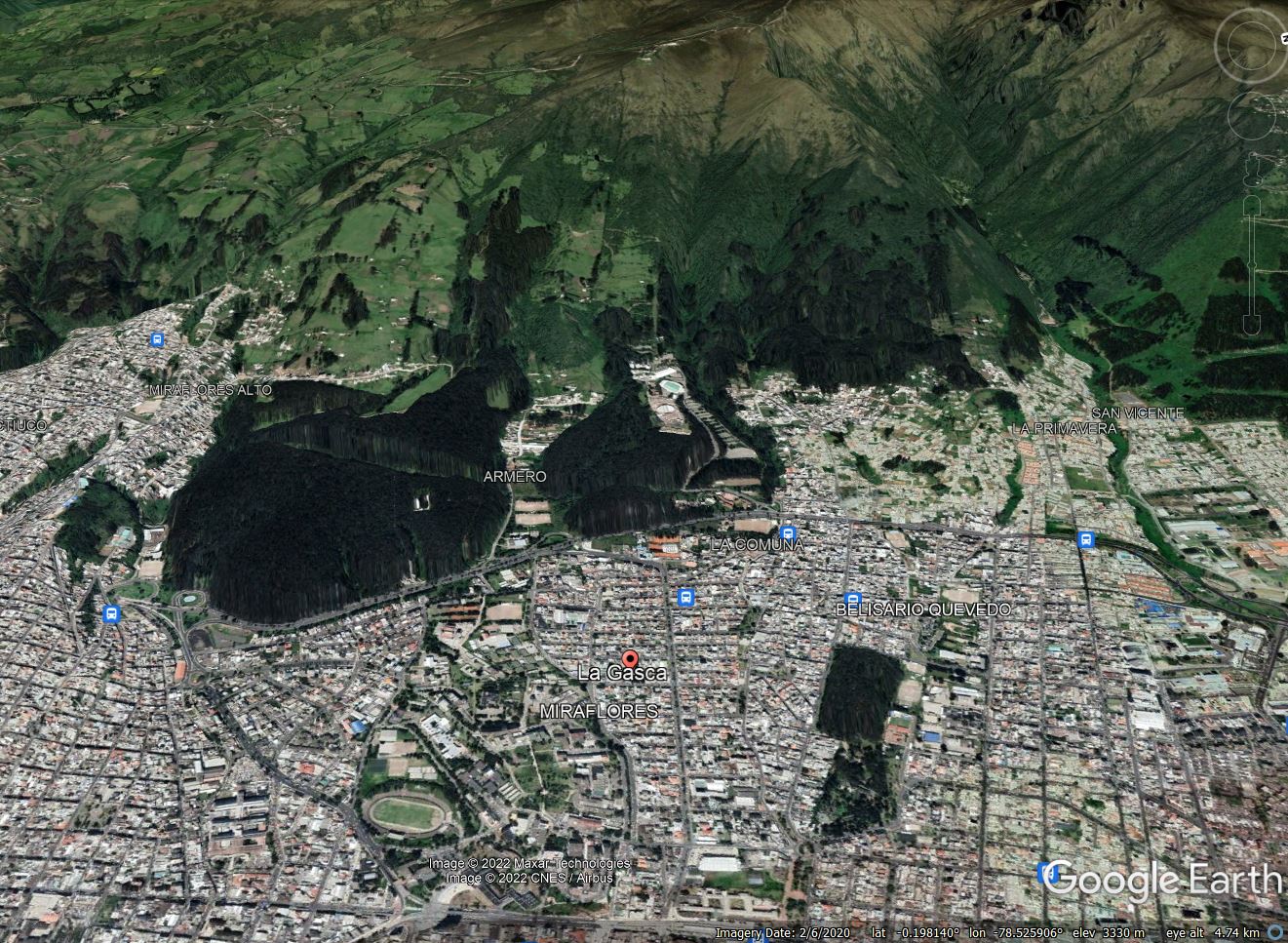
Google Earth image of the area affected by the 31 January 2022 mudflow in Quito, Ecuador.
.
The mudflow has clearly originated on the steep slopes and channels above the city. The elevation difference between the peak and La Gasca is over 1,000 m.
There is dramatic footage of the event as it occurred on Youtube, some of which makes uncomfortable viewing. The footage below gives an idea of the nature of the event:-
.
There is also drone footage of the aftermath:-
.
The image below gives an impression of the scale of the damage:-
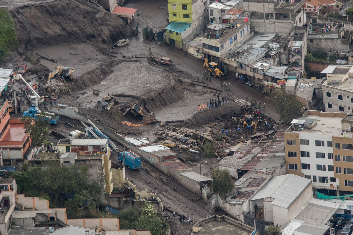
The aftermath of the 31 January 2022 mudflow in La Gasca, Quito. Image by: Carlos Noriega / El Comercio.
.
Interestingly, this area appears to have been affected by a similar mudflow on 25 February 1975, when a mudflow originated from the Pambachupa ravine, affecting the La Mariscal neighbourhood, close to La Gasca. On that occasion two people were killed and a further five were injured.
Perhaps surprisingly, the municipal authorities have ruled out deforestation as being a factor in this event.
 Dave Petley is the Vice-Chancellor of the University of Hull in the United Kingdom. His blog provides commentary and analysis of landslide events occurring worldwide, including the landslides themselves, latest research, and conferences and meetings.
Wow that’s terrible and terrifying. With the slopes above this on the hillside so deforested, and developed I am not sure how the local experts came to a conclusion that deforestation has had no impact on triggering such a dangerous debris flow. There are so many similar slopes around in this google image, that its surprising these floods and debris flows are not more common, especially with increasing storm severity and precipitation intensities forecast expected due to global warming impacts. If I lived below these slopes I would want answers, and I would expect more such targeted disasters below gullies or steep slopes or near slope/drainage modifications. Thanks for sharing these glimpses of how our world is changing as cities grapple with the accelerating climate change, and vulnerable infrastructure with increasing population densities. Not a good situation at all. Save your life – not property – actions should be better communicated it appears. No one thinks clearly unless they prepare for such an event. ..and probably it was unexpected for most people in these images. What a mess. So sorry.. but glad it shows a few people who survived and others who bravely tried to pull them to safety, instead of their clinging on to a mud encrusted motorbike pinned by the flood against a building.
None of the videos show the source of the mud upstream.
It appears the majority flowed through the tunnel below the “Armero” sports fields and then down the road through built up area. i.e. they don’t actually have a storm water channel capable of handling likely rainfall events ?
The mix of high altitude grasslands (paramo) and forest/brush in google maps images is about the same as I recall from the 1960’s. Forest on the lower slopes is largely non-native eucalyptus, grow for firewood. I see some erosion at the upper end of the canyon slope due to footpaths. There is a relatively new cablecar up this slope, with increased foot traffic, including hikers to the 16000 ft summit. The highway and underpass (that channelled the flow to the streets) dates to the 1970s. This ravine seems to be lacking some sort of catch basin above the highway. Signs beside the highway suggest that other ravines to the north have, or will have, catchment basins.
There is some clear imagery from Planet.com from Feb 3 that shows the source area as a shallow draw above the Armero sports field, then coming down towards Vulqano Park before entering the tunnel that Alan refers to above, and then into the city. The imagery is grainy enough that it’s difficult to tell if there’s a single point source, but it appears that the debris flow bulked up as it approached the park and tunnel, mostly flowed through the tunnel (some spilled out of the channel into the upper part of the park), then hit the construction zone then entered the city proper.
https://www.elcomercio.com/video/dron-la-gasca-aluvion-muertos.html shows drone footage of scouring in the Quebra El Tejado. GM Streetview shows some sort of business or construction where this ravine opens onto city streets, 2569 Fulgencio Araujo, with a nearby city sign about sewer works (alcantarillado). So there may have been some sort of catchment, but it clearly was overwhelmed by the volume of the mud flow. Since these are volcanic soils, would this qualify as a lahar?