
9 February 2022
Dosquebradas: at least 14 killed in a landslide in Colombia
Posted by Dave Petley
Dosquebradas: at least 16 killed in a landslide in Colombia
Heavy rainfall triggered a large landslide in the town of Dosquebradas in Colombia yesterday, killing at least 16 people, injuring 34 more. The landslide, which occurred at 6:25 am local time, buried six houses. El Tiempo has a good report (in Spanish – Google translate does a good job).
The newspaper El Spectador has a good image of the site, which consists of a shallow failure in a steep scarp:-
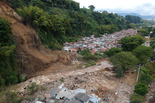
The 8 February 2022 landslide at Dosquebradas in Colombia, which killed 16 people. Image by Santiago Ramirez via El Spectador.
.
Note the location of a high density, informal settlement at the foot of the slope. The same area was impacted by another landslide on 5 October 1976, in which 63 people were killed and a further four were left missing.
Colombia has an excellent, very active landslide research and mitigation community, so some excellent information about this failure has been posted to Twitter. Helbert Schneider, a PhD student at Syracuse University, has tweeted two really interesting insights. The first provides drone footage of the site:–
At least 14 people died and 30 more went injured due to a soil slide in central Colombia.
A drone footage is available and shows the outcome of this tragedy…@davepetley https://t.co/h5YGyVS5AI
— Helbert García-Delgado (@HelbertSchneid1) February 8, 2022
.
Whilst the second provides an overview of the landslide risk at the site:
I've done some observations about the Pereira-Dosquebradas tragedy. First, using the footage available I tentatively located the fatal landslide. The base map corresponds to the landslide/flood hazard map for the city of Pereira reported in the Land use plan. 1/n pic.twitter.com/iOSFeZ3nYs
— Helbert García-Delgado (@HelbertSchneid1) February 9, 2022
In the long run, people may question the meaning of elaborating land use plans. Unfortunately, It seems more like a bureaucratic procedure rather than a risk management process…Meanwhile, vulnerable people are being killed by this ineffectiveness.
— Helbert García-Delgado (@HelbertSchneid1) February 9, 2022
.
In the same Twitter thread, Helbert makes the following observations:
Note how in the mentioned plan [in his first tweet above], the affected area is not recognized as a susceptible area to landsliding. Although the steep slope is north of the Otún River, on the Dosquebradas municipality side, the runout distance was enough to cross the stream…Most deaths occurred on the Pereira side of the Otún River. The available visual material is clear in that the south margin of the Otún River was heavily damaged and where most fatalities were located….Does this mean that geoscientists and engineers failed to recognize this possible scenario? The historical data shows that this area has been affected by fatal landslides in the past. Therefore, the scenario is not new or unexpected.
So, this is a case of known hazard and established risk, but the mechanisms have not been in place to protect the population. This is a scenario that we see over and over again across the world, with tragic outcomes. Colombia has a substantial landslide hazard – I’ve posted previously about research quantifying the level of loss, which provides a better analysis of an earlier analysis that I posted, whilst Sergio Sepulveda and I published an open access article a few years ago looking at patterns of landslide loss across South America (Sepulveda and Petley 2015)
.
Reference
Sepúlveda, S.A. and Petley, D.N. 2015. Regional trends and controlling factors of fatal landslides in Latin America and the Caribbean. Natural Hazards and Earth System Sciences, 15, 1821-1833, doi:10.5194/nhess-15-1821-2015.
 Dave Petley is the Vice-Chancellor of the University of Hull in the United Kingdom. His blog provides commentary and analysis of landslide events occurring worldwide, including the landslides themselves, latest research, and conferences and meetings.
So sorry for the loss of life. This is similar to the Oso Landslide situation in Washington state recently and so many more. The undercutting of a slope by a river on the outside of a meander bend is a disaster waiting to happen. Of course any of the steep slopes above the river if weakened or exposed by humans or vegetation damage could start the sliding process, but undercutting the toe of the slope is an almost certain mechanism for failure. Thanks for the excellent coverage. The problems with land use planning and regulations with expanding cities, and high rainfall intensities is a problem even without global warming but with more warming induced storminess there is a greater need for improved public safety planning. The other places may not be as prone if not on the outside of a river meander bend, but they still are below a steep slope controlled by the river below. Best wishes to the people and engineers and planners trying to keep all safe. A frustrating and scary task with so many similar situations around the world. Hiring good, well trained geoscientists and engineers, land use planners, and supporting their proactive preventative decisions for land use and construction is essential but costly and difficult everywhere, but very much needed. Good luck, good planning and best wishes for improved safety in this and similar situations. Thanks for sharing.
The degree of exposure-vulnerability are the primary factors to be blamed. Insisting on the slide as the cause of the tragedy, is the perfect excuse for decision makers to deny their responsibility in allowing such type of land use. The slide just came first, but a flood would have produced about the same outcome. Slides and floods will come again… we will see if the lesson has been learned or not.