31 August 2022
Leaving the University of Sheffield
Leaving the University of Sheffield
Today is my last day at the University of Sheffield before I move to become Vice-Chancellor at the University of Hull, starting tomorrow.
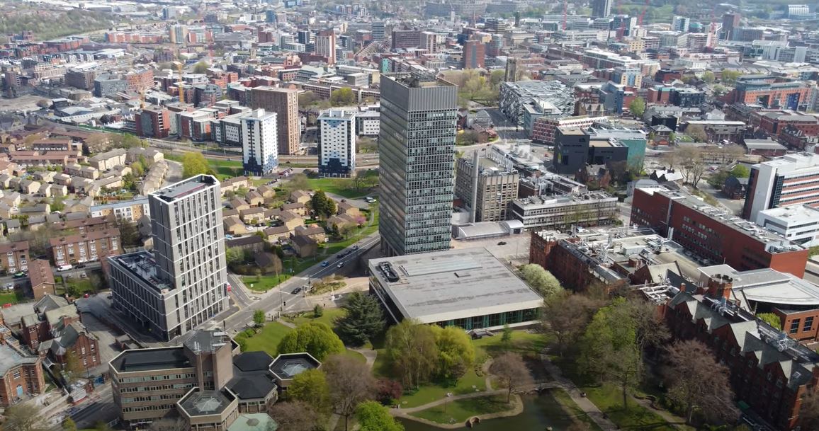
An aerial image of the University of Sheffield campus.
.
I joined the University of Sheffield in November 2016, taking up the role of Vice-President (Research and Innovation). Over time that role evolved such that in recent years I have overseen the Innovation portfolio, including knowledge exchange and regional engagement, and I have provided board level leadership for the Advanced Manufacturing Group, including the AMRC, the Nuclear AMRC and the AMRC Training Centre. Meanwhile I have continued to develop my own research, albeit in a more limited way than before, and of course I have continued to post to this blog.
My time at the University of Sheffield has been simply and truly wonderful. It has been a privilege to work with immensely talented and deeply passionate people. Sheffield is a wonderful city – so dynamic and so friendly, but so very modest about itself. I have many people to thank – it is impossible to pay tribute to you all – but I would like to highlight Elaine, who cleans my office and who is a true friend (I will miss our morning chats); Debbie and Niccole, my long-suffering PAs without whom I could not have functioned; Sarah, who provides inspirational leadership to the Partnership and Regional Engagement team; Vanessa, who leads the university’s exceptional cultural work across the region; Andy, who has transformed the ways in which we commercialise our research; Yasmin, who has brilliantly led the work that we undertake across South Yorkshire; and Wyn, who held the Education portfolio when I was leading research and innovation, and who has been a constant source of support. Behind those wonderful people is a huge wider community of academics and professional service staff, and of course my colleagues in the University executive Board. Thank you to you all.
I do also want to thank my colleagues who have worked with me to transform the AMG. The challenges we faced when we established this new leadership team were complex. Steve, Andy, Nikki, Iain and Beth, and the teams that they lead, have been an inspiration to me. The AMG is a true gem, and I leave it in the very best hands.
I feel proud of what we have achieved. Over the almost six years we changed the ways in which we support our research; we established four new Flagship Research Institutes; we developed a new approach to commercialisation (and I feel so proud of the spinout companies that emerged); we worked with the Universities of Manchester and Leeds to create Northern Gritstone; we created the Advanced Manufacturing Group and reset the strategy of the three component centres; we re-established the role of the University in South Yorkshire and beyond; we have developed the University of Sheffield Innovation District; and so much more. My role has never been anything more than to empower and support those people that do the real work, so the credit lies with them. And of course much of this has been achieved during Covid, which has been extraordinary in so many ways.

Firth Court at the University of Sheffield, my base since 2016.
.
And so now to the the next step. I will leave this afternoon with great sadness but also real pride. The University of Sheffield has been the best of times in my career to date. Thank you Sheffield, I will be forever grateful. There are great times ahead for the institution.
And so to the University of Hull – I feel so very excited about my new role in an institution that is truly wonderful and special.
30 August 2022
The Mount Elbrus boulder video
The Mount Elbrus boulder video
A video was posted on to Youtube on 21 August showing a remarkable rockfall on Mount Elbrus. This is the highest peak in the Caucasus Mountains, rising to 5,642 metres. It is a popular climbing site.
The video, which should be visible below, was captured by Alex09spartak, who seems to be Алекс Никифоров, which Google translate turns into Alex Nikiforov. The original version of the video was posted on Tiktok, which provides the full sequence (and is actually much better than the edited Youtube version).
.
I am not sure as to where the rockfall occurred, but the mountain is at 43.37, 42.45.
The boulder appears to detach from a large area of loose rock. In the early part of the video the boulder is rotating around its shortest axis – as I have noted previously, this allows the boulder to accelerate quickly and to bounce.
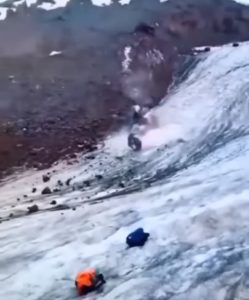
The Mount Elbrus boulder rotating around its shortest axis. Still from a video posted to Youtube.
.
However, the ice surface impedes this type of movement. The boulder stops bouncing and loses its rotation, presumably because of a weaker, smoother and lower friction surface. The boulder quickly starts to slide, and then follows the slope. This is fortunate for the climbers as the trajectory of the rock markedly changes.
.
Acknowledgement
Thanks to loyal reader Dave Eddy for highlighting this amazing video.
5 August 2022
The Imamzadeh Dawood mudflow disaster in Iran
The Imamzadeh Dawood mudflow disaster in Iran
Over the last week Iran has suffered from a series of extreme rainfall events, with catastrophic impacts. Iran Wire reports that at least 90 people have been killed, but there is extensive speculation that the losses may be considerably higher. As is often the case in countries like Iran, there is a lack of clarity as to the true effects. The Red Crescent reports 69 confirmed fatalities and 45 people missing.
One of the most significant events occurred at Imamzadeh Dawood (also spelt Imamzadeh Davood, Emamzadeh Davod and various similar combinations), a religious centre located in the mountains in Sulqan Rural District, Kan District of Tehran County. The location is 35.877, 51.338.
There is little doubt that a very substantial mudflow occurred there on 27 July 2022. EIN News reports that at least 22 people were killed, although the figures differ in other sources. There is a harrowing video of the mudflow at Imamzadeh Dawood on Youtube, which you should be able to view below:-
.
A high death toll would be consistent with the impact of events of this type in similar locations.
There is a gallery of images of the aftermath of the mudflow on the Shafaqna News website. This includes the image below, which shows the magnitude of the impacts:-
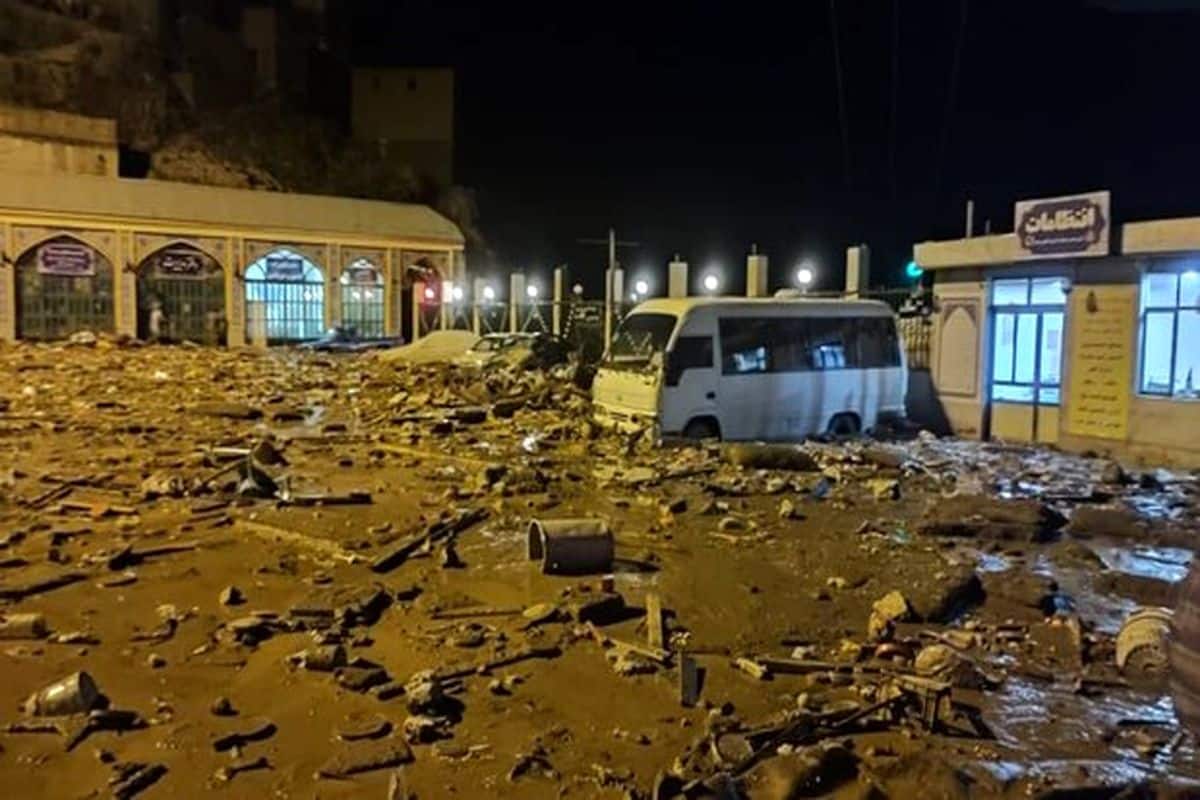
The aftermath of mudflow at Imamzadeh Dawood in Iran. Image from NCRI.
.
The image below is a Planet Labs PlanetScope image of Imamzadeh Dawood, captured yesterday:-
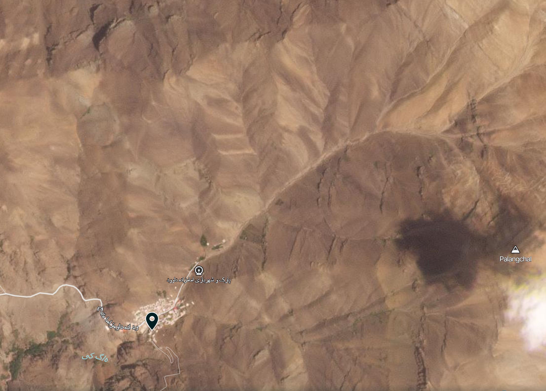
The terrain around Imamzadeh Dawood in the aftermath of the mudflow disaster. Image copyright Planet Labs, used with permission. PlanetScope image captured on 3 August 2022.
.
Imamzadeh Dawood is in the southwest corner of the image, the channel flows from the northeast to the southwest. The image shows extensive change in the channel, marking the track of the mudflow. It appears that the debris has been sourced from the slopes and the channel in the catchment. There is extensive evidence of erosion on the hillslopes and erosion of the riverbed.
It will be interesting to see whether clearer information emerges about the magnitude of the impact of these disasters across Iran.
.
Acknowledgement
Planet Team (2022). Planet Application Program Interface: In Space for Life on Earth. San Francisco, CA. https://www.planet.com/
4 August 2022
The 26 July 2016 landslide at Fushun west pit in China
The 26 July 2016 landslide at Fushun west pit in China
On 26 July 2016 a large landslide occurred in a highwall at a large coal mine in Fushun, China. The landslide, which is described in a paper just published in Landslides (Sun et al. 2022), caused extensive damage.
The impact of the landslide is nicely captured on Google Earth. The site is at 41.8508, 123.8828 – this is an image from November 2014:-
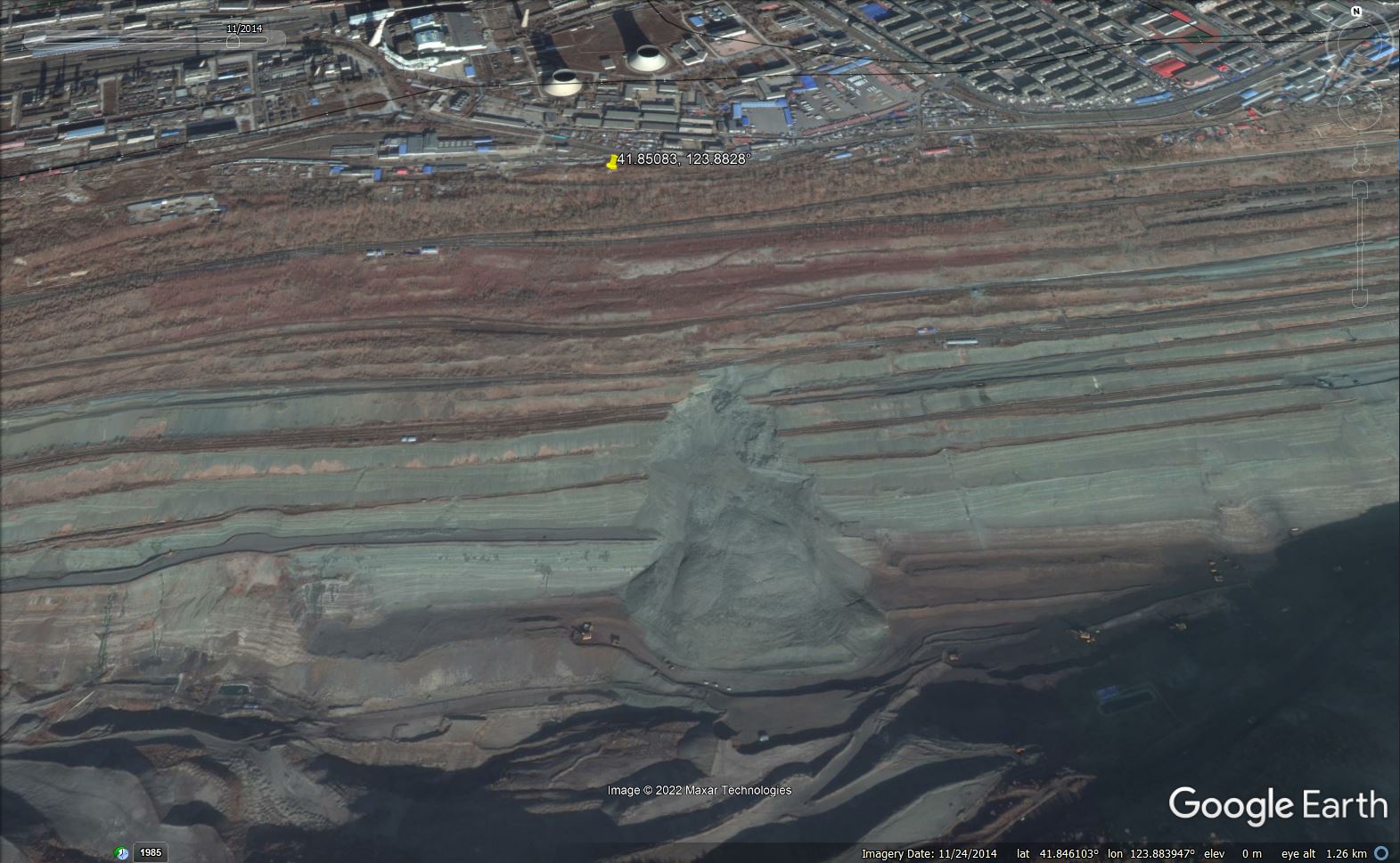
Google Earth image of the site of the 2016 landslide at Fushun in China.
.
Whilst this is an image taken in October 2016, after the landslide:-
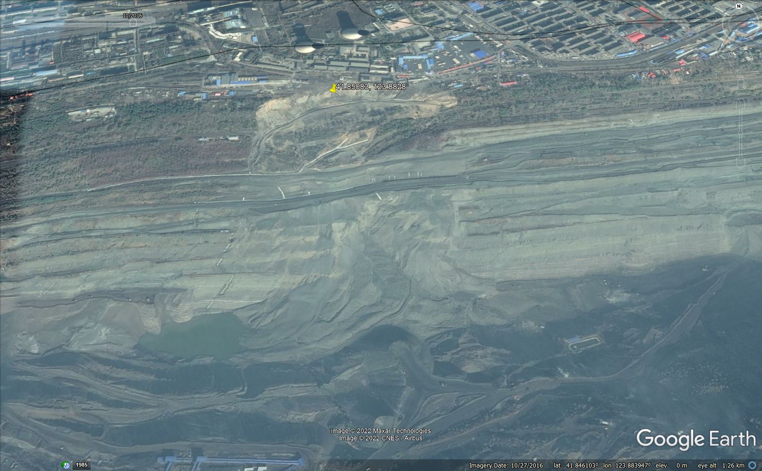
Google Earth image of the aftermath of the 2016 landslide at Fushun in China.
.
This was the largest in a series of landslides that occurred in this coal mine – Sun et al. (2022) describes over 100 landslides over the life of the mine, which seems like a surprisingly high total, especially given the proximity of infrastructure to the edge of the workings. The authors note that these landslides caused “severe damage to buildings, underground pipelines, roads, and railways”.
The 26 July 2016 landslide was on a different scale however. The landslide was 350 m long and 500 m wide, with a volume of 3.1 million cubic metres. It destroyed 40 houses as well causing damage to roads, railway lines, equipment, and buildings.
The landslide itself was a rotational failure in the upper part of the highwall, with a fragmented debris trail on the lower slopes. The image below, from Sun et al. (2022), shows the aftermath of the rotational failure:-
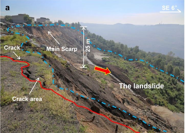
The aftermath of the major landslide at Fushun City in July 2016. Image from Sun et al. (2022).
.
It is interesting to note that the Google Earth imagery shows a substantial landslide on the lower slopes prior to the this very large failure. Sun et al. (2022) do not appear to consider this to have been a factor in the main landslide event, which is interesting. The final trigger for the landslide was heavy rainfall.
The July 2016 Fushun landslide is a very good example of the ways in which long wall mining can trigger destructive instability. In a site with houses located so close to the mining operations, there is a particular responsibility to manage the slopes. The paper rather carefully reports multiple destructive landslide events in this mine; I hope that lessons have been learnt since this major failure.
.
Reference
Sun, S.W., Liu, L., Hu, J.B. et al. 2022. Failure characteristics and mechanism of a rain-triggered landslide in the northern longwall of Fushun west open pit, China. Landslides (2022). https://doi.org/10.1007/s10346-022-01926-3
3 August 2022
The 2 December 2020 Beach Road Landslide in Haines, Alaska
The 2 December 2020 Beach Road Landslide in Haines, Alaska
On 2 December 2020 at 1:17 pm local time a large landslide occurred close to Haines in Alaska. Now known as the Beach Road Landslide, the failure sadly killed two local residents. A team has now undertaken an initial analysis of the landslide, published as an open access paper in the journal Landslides (Darrow et al. 2022).
The landslide itself is clearly visible on Google Earth, located at 59.219, -135.412:-
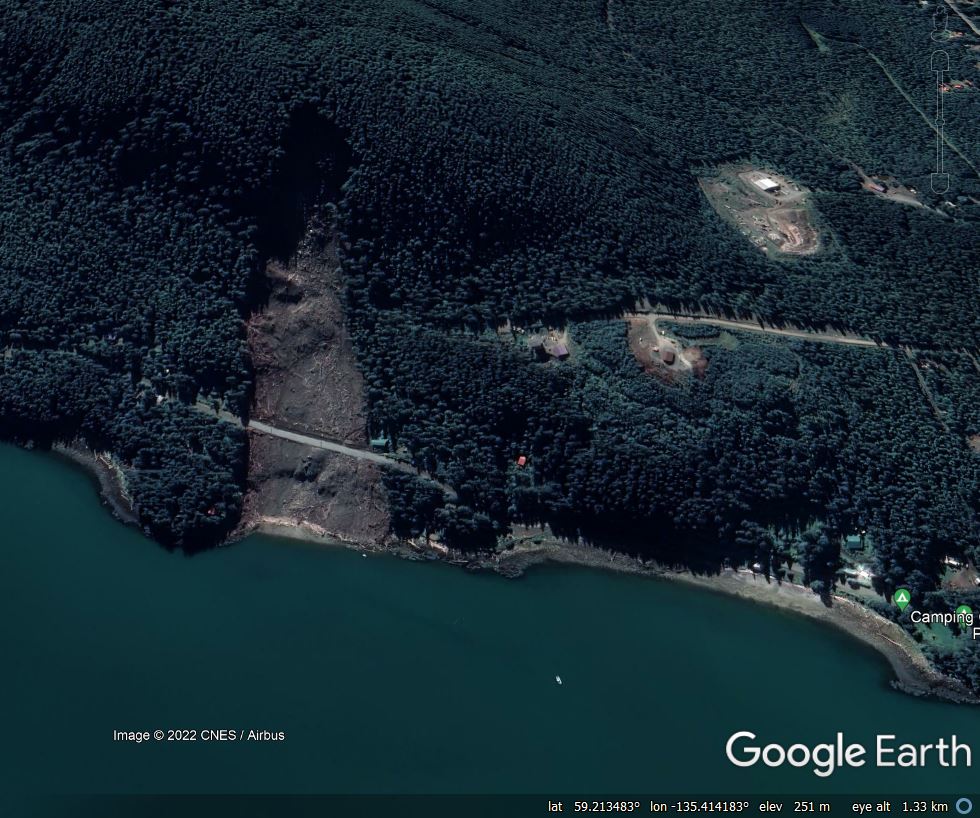
Google Earth image of the 2 December 2020 Beach Road Landslide in Haines, Alaska.
.
The landslide is about 690 m long, 170 m wide, with a volume of about 107,000 cubic metres and an average slope angle of 20 degrees. The landslide was triggered by an “atmospheric river” that generated rain-on-snow, which is dangerous combination for landslide initiation. The failure started as a debris avalanche that transitioned into a debris flow.
Perhaps the most interesting aspect of this paper is the landslide history of the ridge from which the failure initiated. Lidar data was used to map the geomorphology of the site – the team found three large palaeo-landslides, plus a large number of head scarps of previous failures:-
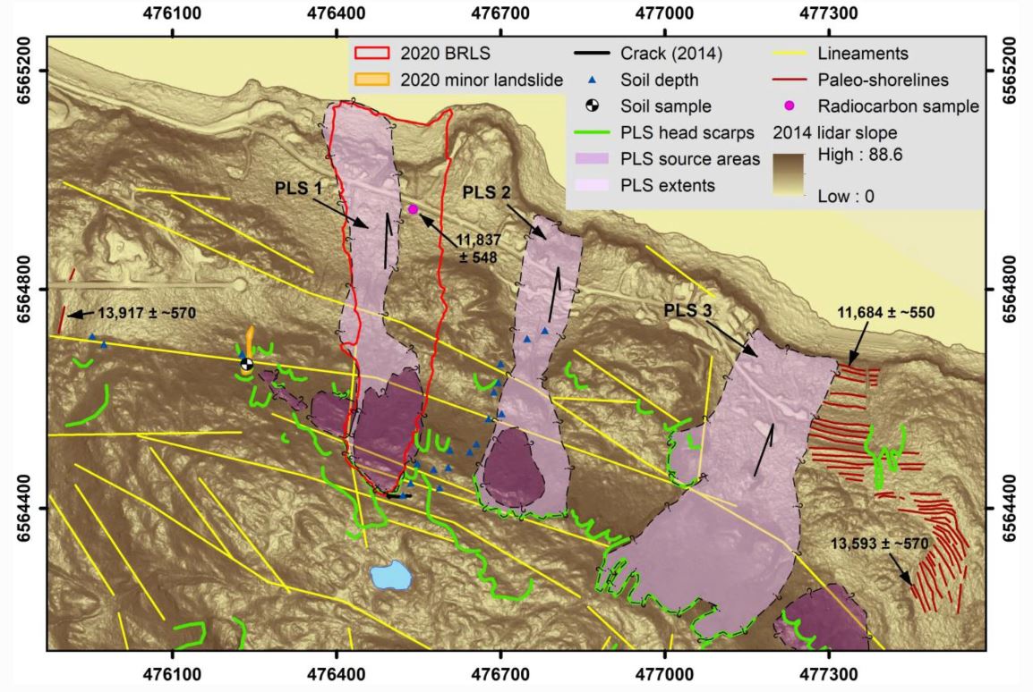
Palaeo-landslides in the vicinity of the 2020 Beach Road Landslide in Haines, Alaska. Image from Darrow et al. (2022).
.
The landslide initiated in a heavily fragmented, displaced area of rock that was evident in Lidar data collected before the landslide, as the diagram above shows (the boundary of the 2020 landslide is outlined in red). Darrow et al. (2022) describe the sequence:
The rock itself is weak and easily disintegrates. Once in motion, the moving rock mass quickly pulverized and incorporated additional water, becoming a debris flow.
Prior to the atmospheric river, snow had accumulated on the site. As the storm passed through the temperature rose above freezing, and on 2 December 168 mm of rainfall fell, breaking the all-time daily precipitation record for the local rain gauge. Over a two day period (1 to 2 December 2022), the precipitation recorded (261 mm) represents a 500 year return period event. Water accumulated in a pond above the head scarp, flowing into fractures in the source area of the landslide.
The final point of note for me from the paper is the key implications of climate change for landslides in this area. Climate models indicate that this area will see higher winter temperatures and increased precipitation. Thus, the slopes will be exposed to more rainfall and more rain-on-snow events. The implications in terms of the likelihood of landslide activity are clear.
.
Reference
Darrow, M.M., Nelson, V.A., Grilliot, M. et al. 2020. Geomorphology and initiation mechanisms of the 2020 Haines, Alaska landslide. Landslides. https://doi.org/10.1007/s10346-022-01899-3
28 July 2022
Landslides from the 27 July 2022 M=7.0 earthquake in Abra, Philippines
Landslides from the 27 July 2022 earthquake in Abra, Philippines
On 27 July 2022 a M=7.0 earthquake struck Abra Province in the northern part of Philippines, with the epicentre being located close to Tayum. Fortunately, this is a lightly populated part of the country, but the Manilla Times is reporting at least five fatalities. The shallow depth of this earthquake (the USGS reports it as 10 km) and the hilly terrain means that landslides are inevitable, and indeed have been widely reported.
The USGS attempts to model likely landslide probability from large earthquakes. Their simulation appears to estimate an extensive area with high landslide probability:-
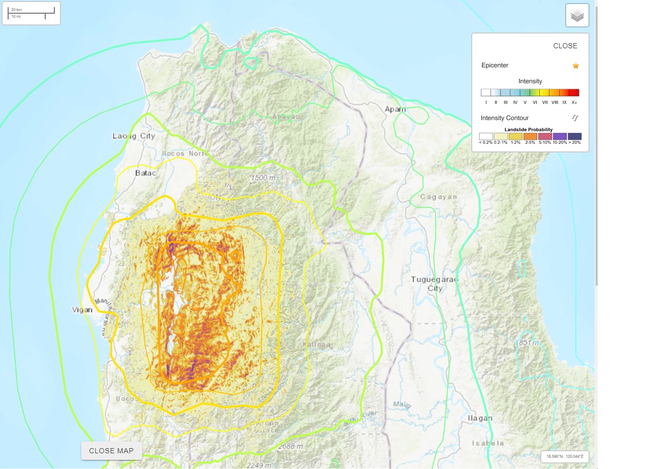
A USGS estimate of landslide probability from the 27 July 2022 earthquake in the Philippines.
.
Some reports of landslides have already emerged. The Manila Times reports two fatalities from landslides:-
“[A] person was killed when boulders smashed into the building site where he was working in Kalinga province, police said. Six other workers were injured. Police said an elderly woman in Suyo municipality in Ilocos Sur province suffered fatal injuries after she was buried by a landslide while out walking.”
Meanwhile, the Manila Bulletin reports a further fatal landslide in Benguet:–
“A 32-year old laborer died after he was buried in a landslide that was triggered by the 7.0 magnitude earthquake in Tuba, Benguet. The victim was identified as Resty Emperador Tavas, a native of Pugo La Union, and a stay-in Laborer at M.A. Camilo Construction, Sitio Bayacsan, Taloy Sur, Tuba. Police Capt. Marnie Abellanida, spokesperson of the Police Regional Office-Cordillera Administrative Region, said Tavas’ coworkers survived the landslide that occurred at around 8:45 a.m. on Wednesday, July 27.”
Meanwhile, some images of landslides have emerged:-
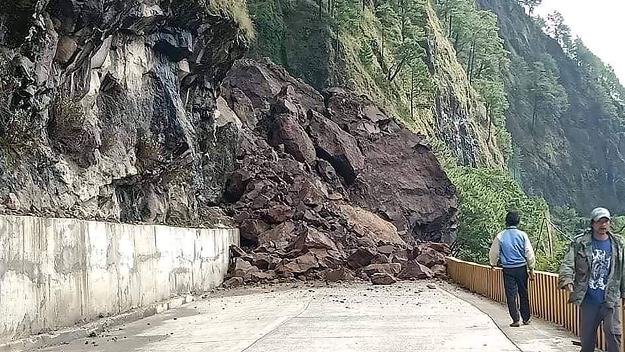
A landslide blocking a road on the Halsema Highway near to Bontoc. Image released by the The Mountain Province Disaster Risk Reduction Management Office.
.
AP has released this very dramatic image of a rockfall in Bauko, Mountain Province:-
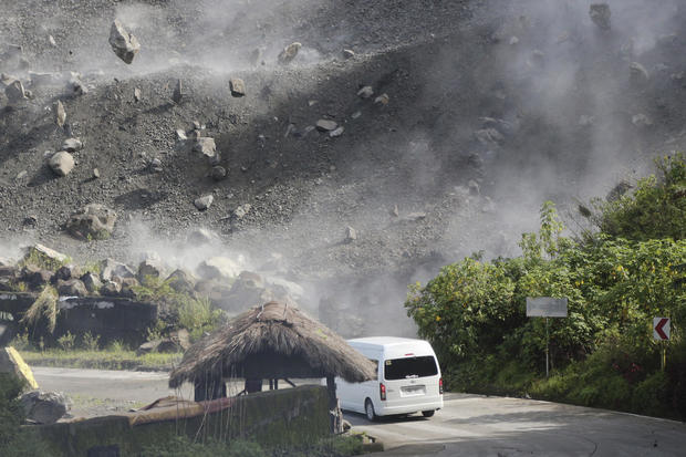
A landslide occurring at Bauko in the aftermath of the 27 July 2022 earthquake in Philippines. Image by Harley Palangchao / AP.
.
It is likely that there will be many more landslides in the upland areas, and that a further round of landslides will be triggered in the first heavy rainfall event following the earthquake.
26 July 2022
The risk of large rockslides at the port of Skagway in Alaska
The risk of large rockslides at the port of Skagway in Alaska
Skagway is a small borough in Alaska with a population in the 2020 census of 1,240 people. In the summer months it becomes a key tourist destination – according to Wikipedia it attracts over a million visitors per year, with the vast majority arriving on cruise ships. The port also processes iron ore mined from within the hinterland. Thus, the port, shown in the Google Earth image below, is of critical importance to the region.
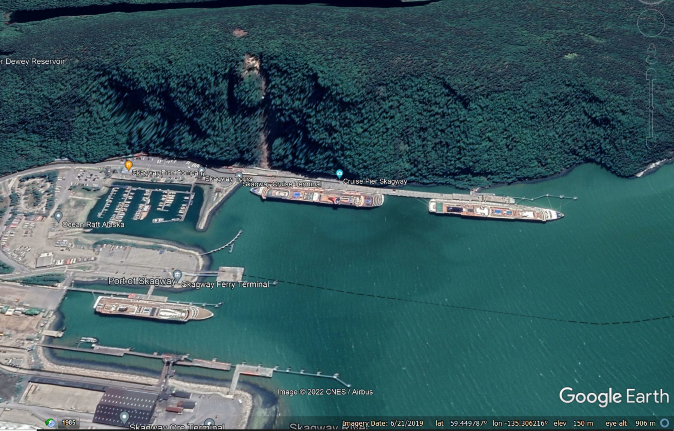
Google Earth image of the port at Skagway.
.
As the image above shows, one section of the port abuts a steep rockslope, which is about 220 m high. This section provides mooring for large cruise ships. In 2017 two rockslides occurred on this slope – indeed, the scar of one of these events can be seen in the image above. In June 2022 a further rockslide occurred, causing a cruise ship to divert.
The port authority is the White Pass and Yukon Railroad. The local authority, the Municipality of Skagway, has commissioned an initial inspection of the slope by Shannon and Wilson, geotechnical consultants. Admirably, their initial assessment has been published online and is discussed in a recent article by KTOO. It does not make easy reading.
Included in the report is the image below, showing the slope and the recent rockslides, and providing a decent context for the hazards posed by failures from the slope:-
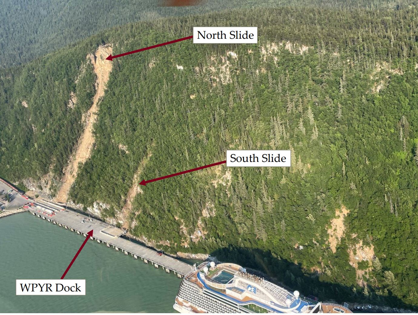
The potentially hazardous rockslope at Skagway in Alaska. Image from a report by Shannon and Wilson.
.
There are some really interesting observations in the report:
- The slope shows evidence of past failures, including scars and debris piles;
- The larger of the two 2017 failures (the North Slide in the image above) came from an area high on the slope that underwent toppling failure. There is a large mass on the slope that is at risk of further collapse;
- An extensometer installed in this mass after 2017 has shows an average movement rate of about 40 mm per year. Recently this has increased to about 65 mm per year.
The consultants conclude that this part of the port at Skagway is at risk from a largescale rockslope failure form the mass at the top of the North Slide:
Given our onsite observations, reported historic movement of the slide mass, and the apparent increase in movement rates measured by the instrumentation, we believe that there is a significant risk associated with complete failure of this feature. It is our opinion that the slide mass will eventually fail and the consequences of such failure will be catastrophic in nature with significant risks to life and property. The timing of such a failure is difficult to predict but accelerating movement rates suggest that the failure event is approaching.
The consultants recommend major engineering works to mitigate the risk in the long term. In the short term they recommend the installation of a warning system and evacuation plan.
The long term measures to protect the cruise port at Skagway are likely to be a significant financial burden for small community. There is an interesting interview on the Alaska Public Radio website with Reba Hylton from the Skagway Assembly, which highlights that there are ongoing discussions regarding responsibility for the works (the rockslope might be on municipal land). Meanwhile, additional measures have been put in place to protect port users.
25 July 2022
New peat landslides in Shetland (including a very interesting landslide video)
New peat landslides in Shetland (including a very interesting landslide video)
The Shetland islands, off the far north coast of Scotland, are covered with large amounts of blanket bog. In such settings, exceptional rainfall and/or disturbance of the peat by human activity can trigger peat landslides – there was for example a large failure at Scalloway in Shetland in 2012 and there were multiple peat landslides in a heavy rainfall event in Shetland in September 2003 (Dykes and Warburton 2008).
On 4 July 2022 a landslide was triggered on the Mid Kames Ridge in Shetland. There is a Youtube video of the setting of the Mid Kames Ridge taken from a drone, including views of the access roads and pads for a large windfarm, which includes 103 turbines across several sites, and which is under construction by Viking Energy. There seems to be little dispute that the peat landslide was associated with the windfarm construction.
The Shetland News has posted an article about the landslide, which includes a remarkable video posted to Facebook by the Stop Viking Energy Windfarm group. This video shows the landslide in motion, carrying an area of crushed rock, presumably a part of the windfarm infrastructure. This still from the video shows the material that failed:-
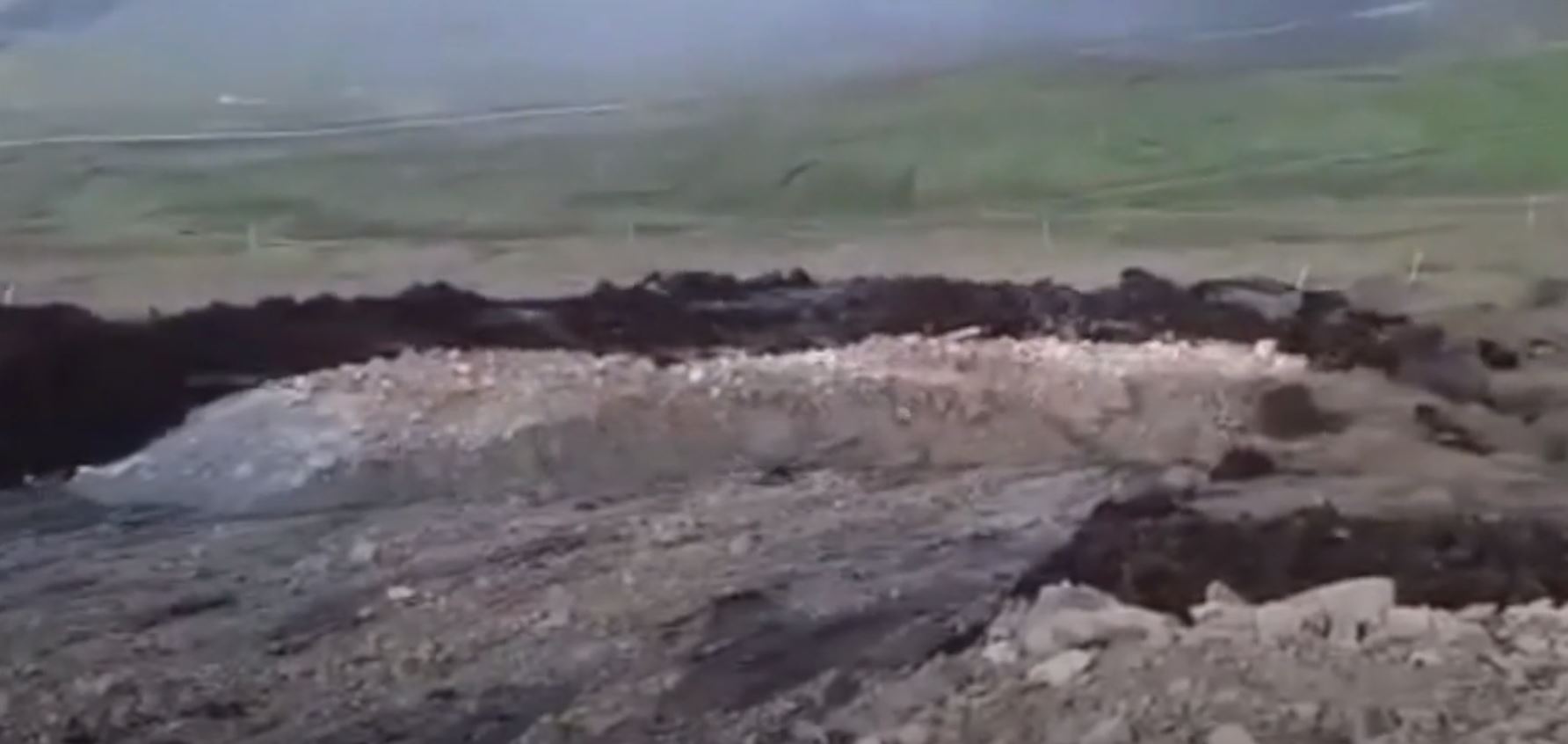
The 4 July 2022 landslide on the Kames Ridge in Shetland. Image from a video posted to Facebook by the Stop Viking Energy Windfarm group.
.
The video is also on Youtube and should be visible below:-
.
This is a remarkable example of a peat slide in action – there are few such videos around. The Shetland News reports that the area has been stabilised and some reinforcement has been placed to prevent a recurrence. However, experience says that remediating the site of such landslides is very difficult. The scar from another peat landslide on the Kames Ridge, which occurred in 2015, remains visible.
On 23 June 2022, less than two weeks prior to the landslide Mid Kames Ridge , I published an article in Ground Engineering warning of the risk of peat landslides associated with windfarm development. I said:
“Onshore wind development can pose a real threat to peatlands. If poor ground engineering practices are deployed, large-scale failures can occur, causing massive peat degradation and inflicting a high environmental cost downstream. The development of new wind farms in peatland areas will pose substantial ground engineering challenges.”
Meanwhile, yesterday another landslide occurred on Shetland, triggered by heavy rainfall. Again, it seems likely that this is a peat landslide, although on this occasion it does not seem to have been related to a windfarm. It partially blocked a road at Vidlin Junction. The Shetland News has a photograph:-
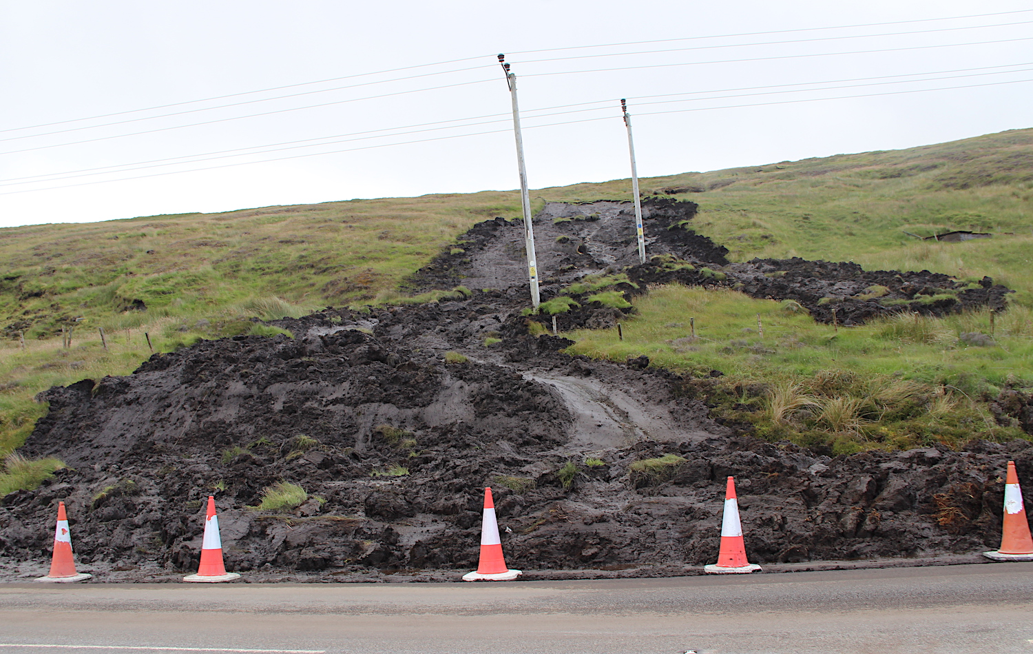
The 24 July 2022 landslide at Vidlin Junction in Shetland. Image from the Shetland News.
.
Reference
Dykes, A.P. and Warburton, J. 2008. Characteristics of the Shetland Islands (UK) peat slides of 19 September 2003. Landslides 5, 213–226 (2008). https://doi.org/10.1007/s10346-008-0114-7
21 July 2022
Mudflows at the site of the Pipeline Fire in Arizona
Mudflows at the site of the Pipeline Fire in Arizona
In the middle of June 2022 the so-called Pipeline Fire broke out in Coconino National Forest in Arizona. With a total surface area of 10,737 hectares, this was a large and damaging wildfire. The cause is as yet to be officially determined; last week a man was convicted of starting a fire close to his camp, less than 100 m from where the fire started.
It is well-documented that wildfires leave the landscape vulnerable to mudflows, some of which can be deadly. On 15 July 2022 heavy rainfall triggered mudflows in the burnt area of the Pipeline Fire. Arizona Game and Fish has posted a dramatic video of one of these to Youtube:-
.
There is a further excellent video in an article on the mudflows in the Arizona Daily Sun. The video is about halfway through the article. The same piece provides useful detail on the nature of the flows:-
The boulder field seen at Copeland Wash is the result of the watershed’s natural alluvial fan “unraveling,” explained Coconino County deputy manager Lucinda Andreani. Above the Timberline neighborhood, there was a place in the Copeland Wash that naturally fanned out and allowed water to slow down, spread out, and drop sediment.
But during the extreme flows of Friday’s flood events, this fan could not contain the water coming off the burn scar. Instead of spreading out, the water eroded into and “channelized” the fan, turning it a source of new sediment — and boulders up to five feet in diameter — to be washed downstream.
The image below shows the aftermath of the mudflows in the area of North Copeland Lane (location: 35.313, -111.554):-
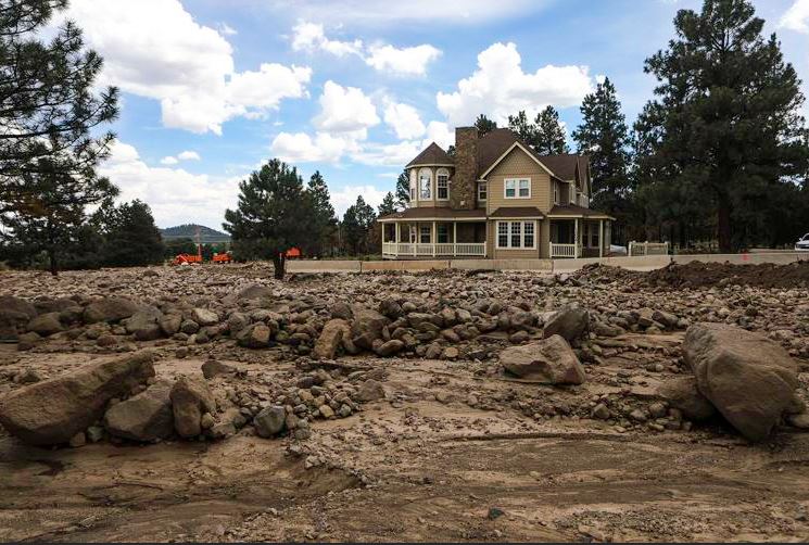
The aftermath of the mudflows from the scar of the Pipeline Fire in Arizona. Image by Rachel Gibbons, Arizona Daily Sun.
.
The scar of the mudflows is visible in Planet Labs imagery captured on 19 July 2022:-
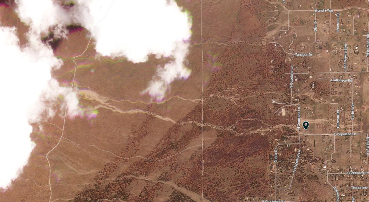
The aftermath of debris flows from the Pipeline Scar in Arizona. Image copyright Planet Labs, used with permission. Image dated 16 July 2022.
.
Further mudflow events are likely through the summer rainy season from this, and of course other, wildfire scars. The estimated cost of mitigation of mudflows in the aftermath of the Pipeline Fire alone is estimated to be $20-30 million.
.
Reference
Planet Team (2022). Planet Application Program Interface: In Space for Life on Earth. San Francisco, CA. https://www.planet.com/
15 July 2022
Landslides triggered by exceptional rainfall in Australia
Landslides triggered by exceptional rainfall in Australia
The last few months have seen a series of exceptional rainfall events in the eastern part of Australia, triggering extensive flooding and landslides. In recent says this series of events has continued, with another major rainfall event causing extensive problems. Loyal reader Scott Johnson has kindly provided a series of updates to me as these events have developed.
The landslide with the largest long term impact occurred at Blackheath in New South Wales on Main Western Line, a major railway through the Blue Mountains. A set of images were posted to Facebook by Transport for NSW – this one shows the scale of the landslide:-
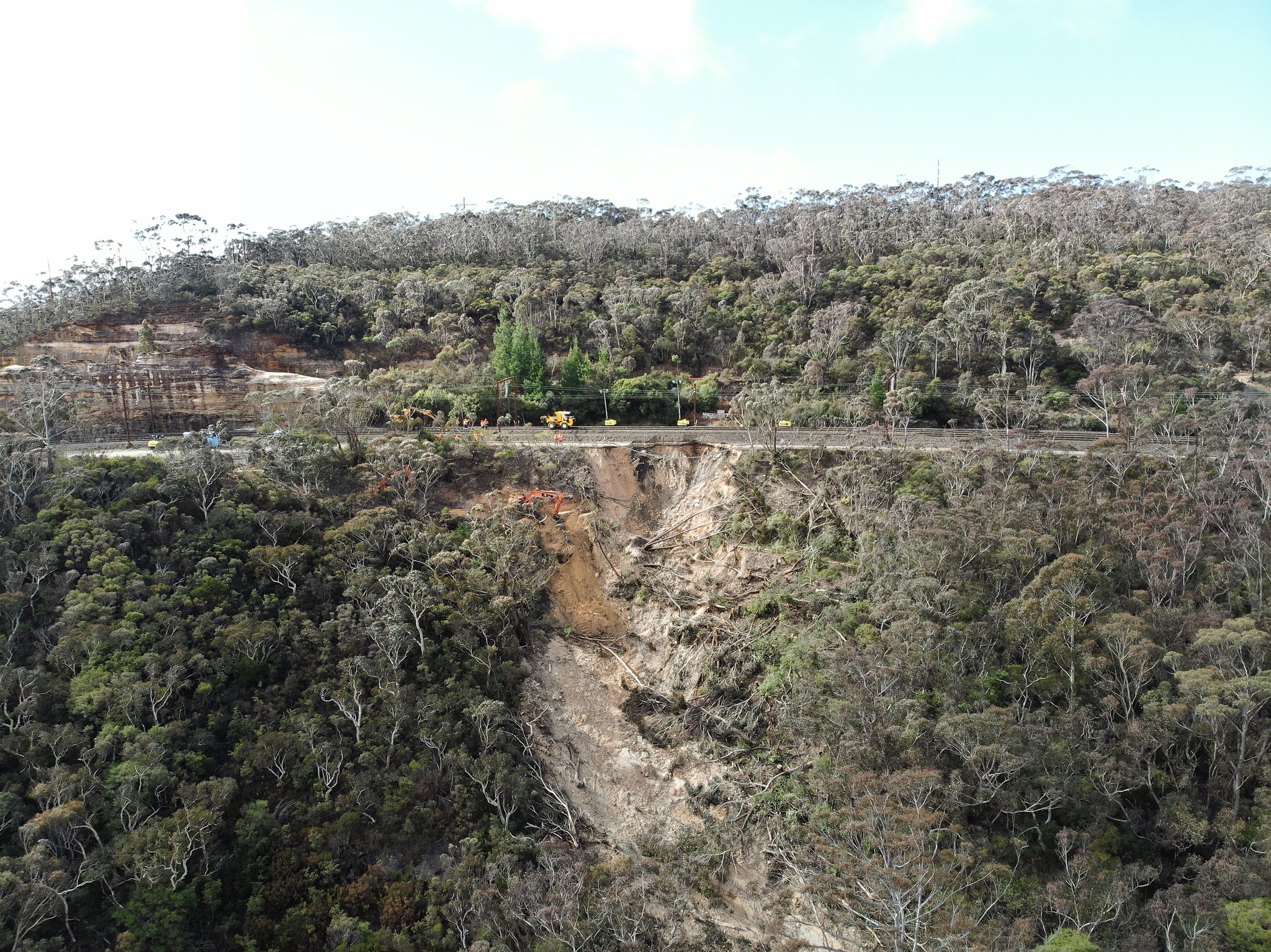
The landslide at Blackheath in New South Wales. Image posted to Facebook by Transport for NSW.
.
Clearly in global terms this landslide is not large, but it is undoubtedly serious. The nature of the terrain, and the remote location, means that mitigation is extremely challenging. Transport for NSW has posted a video update on the ongoing mitigation works. This still shows the scale of the excavations that have been necessary to reach a firm foundation, allowing a stable slope to be created to provide a secure track bed:-
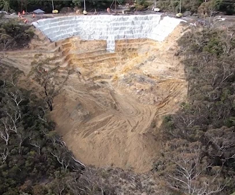
Ongoing mitigation of the landslide at Blackheath in New South Wales. Image from a video posted to Facebook by Transport for NSW.
.
The target date to get one line functioning is 24 July 2022, with a focus on night time freight traffic in the first instance. The line is a critical route for the transport of grain, coal, minerals and meat across the Blue Mountains to Sydney and the east coast area. Thus, the economic cost of this landslide is likely to be high.
Meanwhile, on the banks of the Hawkesbury River in NW Sydney, a rather different landslide problem has developed at Richmond Lowlands. ABC News has a good video report about this event, triggered by flooding on the river. This still from the video shows the scale of the problem:-
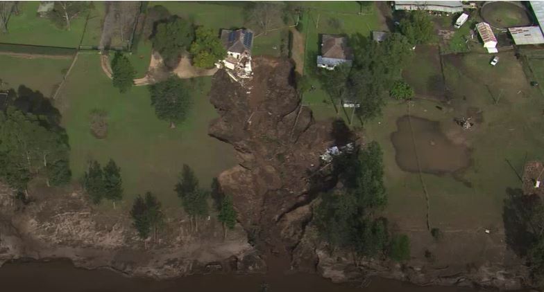
The landslide at Richmond Lowlands on the Hawkesbury River. Still from a video by ABC News.
.
The house is, I believe, located at -33.5667, 150.7624. The flooded area on the right side of the image presumably indicates that the ground was saturated whilst the river was in flood at the time of the failure. A flood warning bulletin released on Sunday 10 July indicates that the river level was falling at that time. The landslide is reported to have occurred at about 10 am on Monday 11 July, indicating perhaps that it was a drawdown failure. The form of the landslide indicates that it might have been a retrogressive event, initiated by collapse of the riverbank at the toe.
It is not immediately obvious to me why such a large failure has developed at this particular location. Failures have developed at other sites too.


 Dave Petley is the Vice-Chancellor of the University of Hull in the United Kingdom. His blog provides commentary and analysis of landslide events occurring worldwide, including the landslides themselves, latest research, and conferences and meetings.
Recent Comments