25 July 2022
New peat landslides in Shetland (including a very interesting landslide video)
Posted by Dave Petley
New peat landslides in Shetland (including a very interesting landslide video)
The Shetland islands, off the far north coast of Scotland, are covered with large amounts of blanket bog. In such settings, exceptional rainfall and/or disturbance of the peat by human activity can trigger peat landslides – there was for example a large failure at Scalloway in Shetland in 2012 and there were multiple peat landslides in a heavy rainfall event in Shetland in September 2003 (Dykes and Warburton 2008).
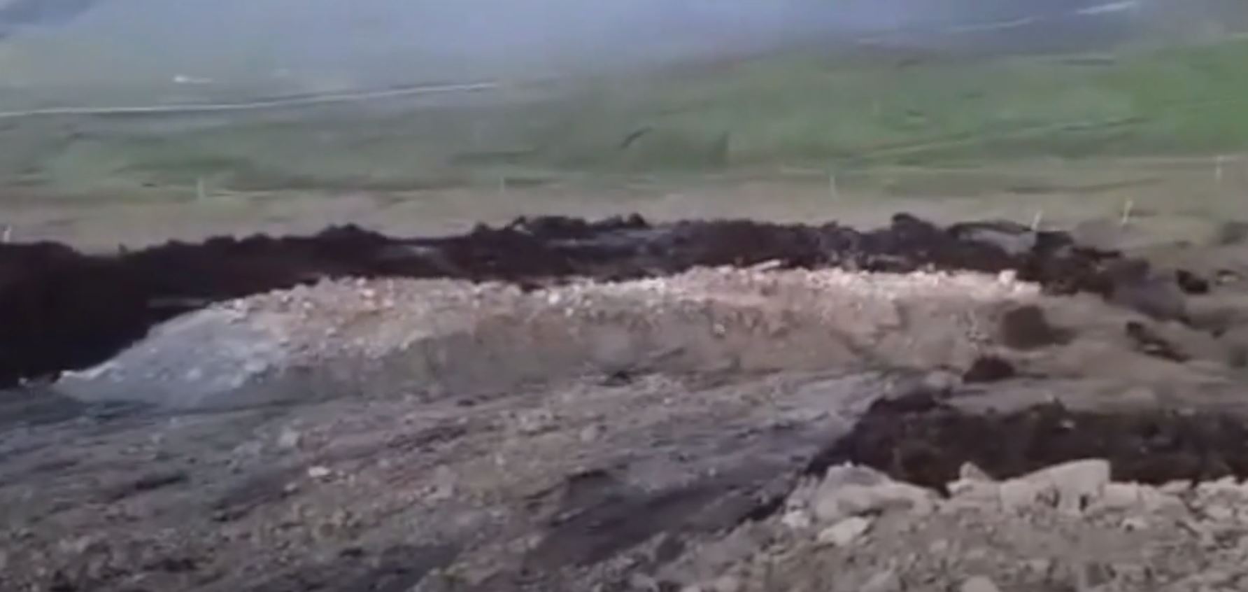
On 4 July 2022 a landslide was triggered on the Mid Kames Ridge in Shetland. There is a Youtube video of the setting of the Mid Kames Ridge taken from a drone, including views of the access roads and pads for a large windfarm, which includes 103 turbines across several sites, and which is under construction by Viking Energy. There seems to be little dispute that the peat landslide was associated with the windfarm construction.
The Shetland News has posted an article about the landslide, which includes a remarkable video posted to Facebook by the Stop Viking Energy Windfarm group. This video shows the landslide in motion, carrying an area of crushed rock, presumably a part of the windfarm infrastructure. This still from the video shows the material that failed:-

The 4 July 2022 landslide on the Kames Ridge in Shetland. Image from a video posted to Facebook by the Stop Viking Energy Windfarm group.
.
The video is also on Youtube and should be visible below:-
.
This is a remarkable example of a peat slide in action – there are few such videos around. The Shetland News reports that the area has been stabilised and some reinforcement has been placed to prevent a recurrence. However, experience says that remediating the site of such landslides is very difficult. The scar from another peat landslide on the Kames Ridge, which occurred in 2015, remains visible.
On 23 June 2022, less than two weeks prior to the landslide Mid Kames Ridge , I published an article in Ground Engineering warning of the risk of peat landslides associated with windfarm development. I said:
“Onshore wind development can pose a real threat to peatlands. If poor ground engineering practices are deployed, large-scale failures can occur, causing massive peat degradation and inflicting a high environmental cost downstream. The development of new wind farms in peatland areas will pose substantial ground engineering challenges.”
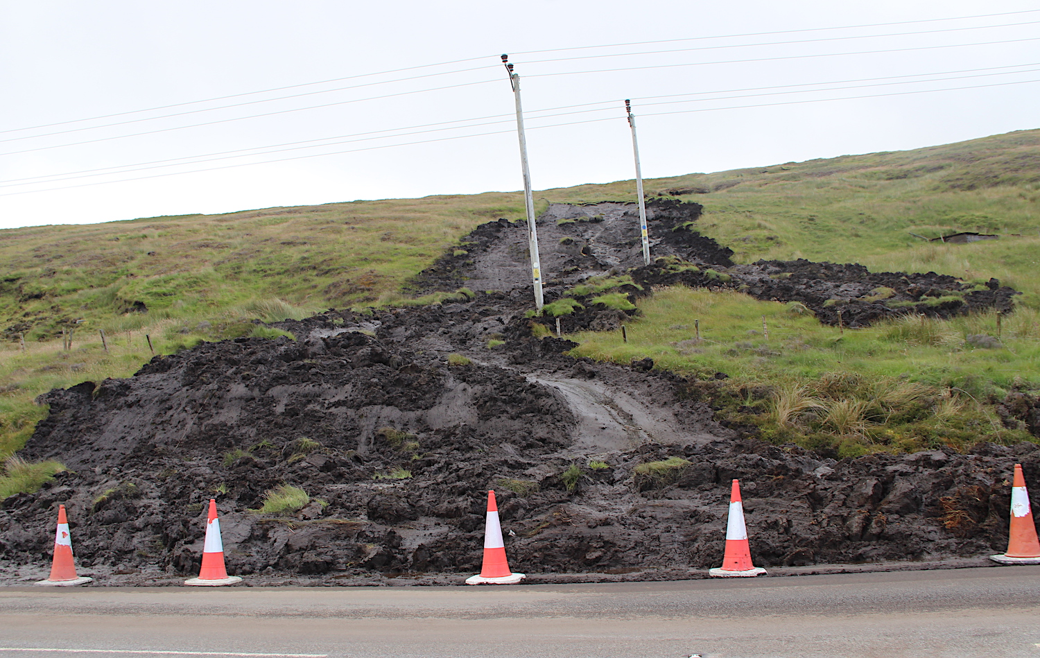
Meanwhile, yesterday another landslide occurred on Shetland, triggered by heavy rainfall. Again, it seems likely that this is a peat landslide, although on this occasion it does not seem to have been related to a windfarm. It partially blocked a road at Vidlin Junction. The Shetland News has a photograph:-

The 24 July 2022 landslide at Vidlin Junction in Shetland. Image from the Shetland News.
.
Reference
Dykes, A.P. and Warburton, J. 2008. Characteristics of the Shetland Islands (UK) peat slides of 19 September 2003. Landslides 5, 213–226 (2008). https://doi.org/10.1007/s10346-008-0114-7


 Dave Petley is the Vice-Chancellor of the University of Hull in the United Kingdom. His blog provides commentary and analysis of landslide events occurring worldwide, including the landslides themselves, latest research, and conferences and meetings.
Thanks for posting this Dave. Interesting to see the much higher density clay plug pushing the peat downslope and to the margins. Also fascinating to watch it accelerate before stalling mid-slope. The failure surface looks to be well below the peat/substrate interface in this case, that or it is side-cast material that has remobilised after being placed. Sometimes contractors place excavated materials on top of peat (inadvisable).
The previous mid-Kame slip (which is visible from the main road) can be seen at c. 7 minutes on the drone video you’ve linked to. It occurred prior to any groundworks, though could have been taken as a warning of potential for instability along that ridge. A similar event appears to have occurred around 18 months ago: https://www.shetnews.co.uk/2021/04/19/viking-energy-sceptics-raise-concern-over-peat-slides/
In terms of your article, it has been good practice for 15 years now to assess peat landslide risk for Section 36 wind farm applications (>50MW, c. 15 turbines in today’s money) in Scotland. Landslide risk assessments are typically GIS based, informed by site visits and detailed peat depth probing. They should include qualitative and quantitative assessment of landslide likelihood, identification of receptors and calculation of risk. Appropriate mitigation should be specified and carried forward into construction as part of a Construction Environmental Management Plan (CEMP). The landslide guidance is here: https://tinyurl.com/47dacvpr.
In terms of restoration, as you note, this is now increasingly part of applications in Scotland (and elsewhere). However, note that a primary aim of peatland restoration is elevating water tables and increasing ground wetness, something that is usually the opposite of the aim when managing slopes. I’ve been working on this with Peatland ACTION over the last couple of years.
As noted by Dave and Andy M, this is a really interesting video. My interpretation, similar to Andy’s, is that it is showing placed fill sliding on a basal peat shear surface, the original peat having failed in response to the loading and then been pushed ahead of it. I have seen similar after-effects at the Sonnagh Old windfarm peat flow (Co. Galway, October 2003) and a detailed report on the large Derrybrien failure earlier in October 2003 suggested something similar.
Dave’s post cites a paper I wrote with Jeff Warburton on the Shetland peat slides triggered by an extreme rainfall event on 19 September 2003. In recent years I have monitored Google Earth imagery of key locations and discovered that at least two of the peat slides we reported did not occur during that event as originally assumed and stated in the paper. To put the record straight, slides #6 and #10 in our paper are visible in imagery dated mid-July 2003, and some of the features we identified as #9 can also be seen in this earlier view. The conclusions of the paper are not affected by the removal of these three landslides from the data.