
23 November 2022
High resolution Planet Labs images of the Kusiong landslides in the Philippines
Posted by Dave Petley
High resolution Planet Labs images of the Kusiong landslides in the Philippines
Earlier this month I posted Planet Labs PlanetScope imagery of the Kusiong landslides in the Philippines. Rob Simmon has now acquired on my behalf a high resolution SkySat image of the area that shows the full extent of the devastation that the landslide have caused:-
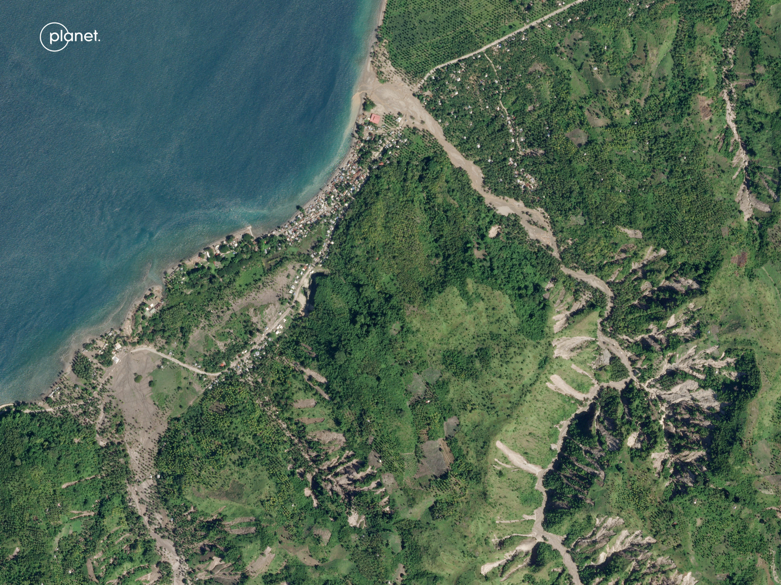
Planet Labs SkySat image of the Kusiong landslides in the Philippines. Image copyright Planet Labs, used with permission, captured on 12 November 2022.
.
This is just a part of the area affected by the landslides – see my original post for the full extent. In this area multiple shallow landslides can be seen, clustered on the slopes in the upper part of the catchments:-
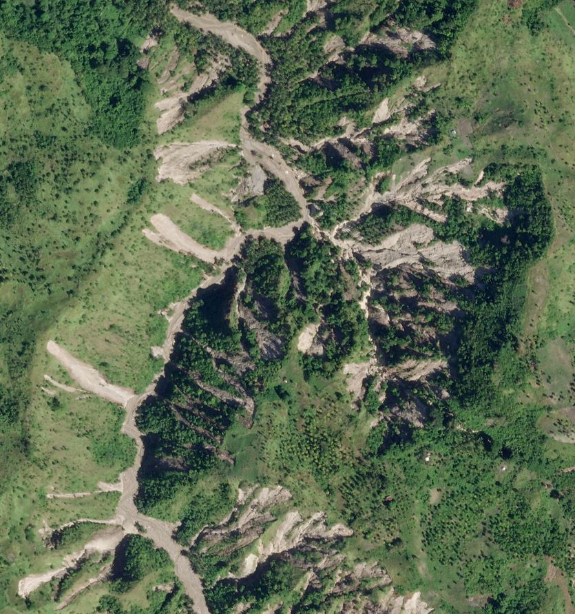
Planet Labs SkySat image of a cluster of the Kusiong landslides in the Philippines. Image copyright Planet Labs, used with permission, captured on 12 November 2022.
.
In this image alone there are over 50 landslides. Note that they are all shallow, that they originate high on the slope (which is likely to indicate failure driven by saturation caused by very intense rainfall) and they connect to the river system. Thus, as I noted previously, this is a tragic, textbook example of shallow failures transitioning to channelised debris flows.
Elsewhere in the image the impact of the debris flows on communities is clearly visible:-
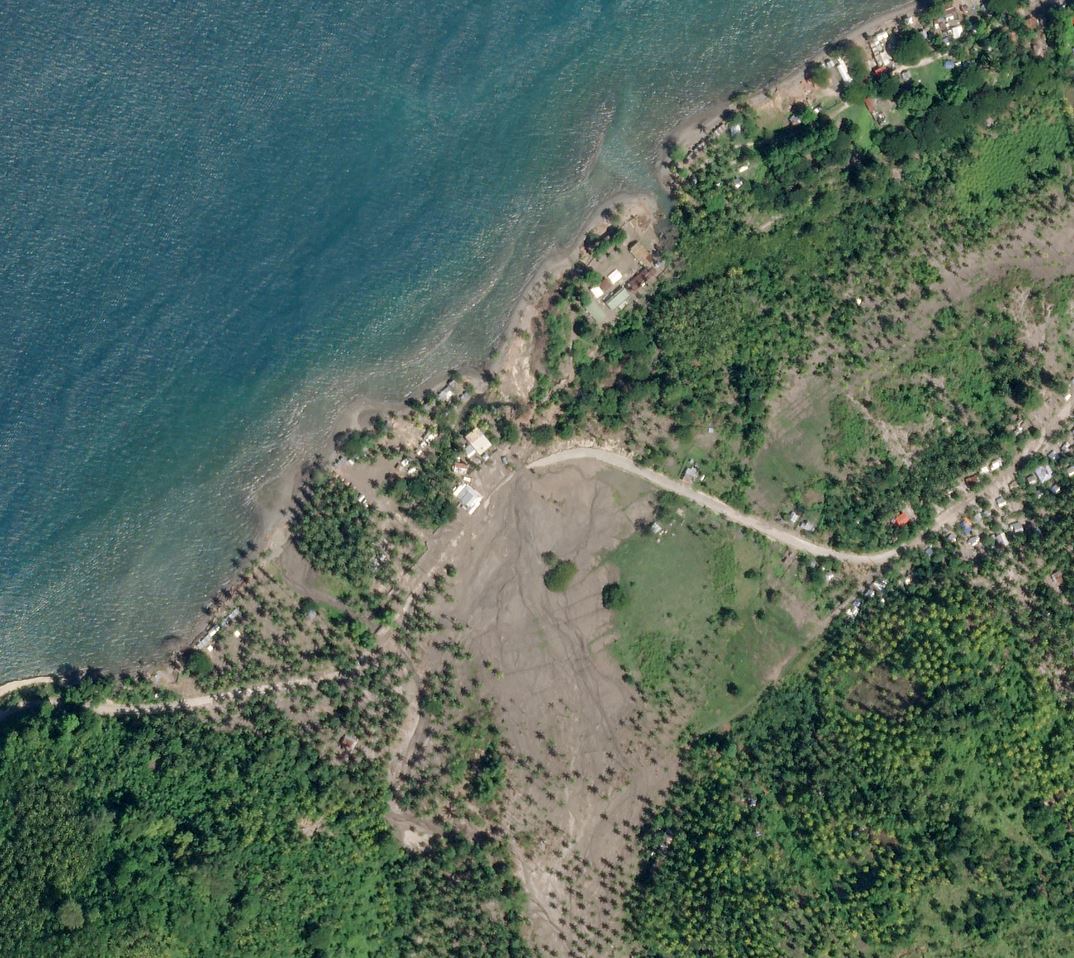
Planet Labs SkySat image of a destructive debris flow, part of the Kusiong landslides in the Philippines. Image copyright Planet Labs, used with permission, captured on 12 November 2022.
.
Note the inundation of the houses and the damage to the land at this site. It is notable that at the time of acquisition the road remained covered in debris.
The most serious damage, and many of the fatalities, occurred in a settlement on the upper slopes at 7.142, 124.088. This is the location of the photograph that I originally posted. The magnitude of the destruction at this location is laid bare in the imagery:-
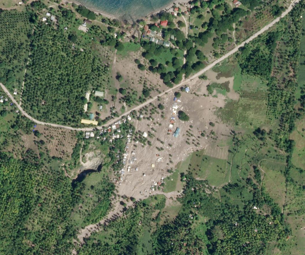
Planet Labs SkySat image of the destruction caused by the Kusiong landslides in the Philippines. Image copyright Planet Labs, used with permission, captured on 12 November 2022.
.
Many houses were destroyed in this community. Interestingly, Google Earth imagery from September 2019 shows no community at this site, and from December 2020 show just a small number of houses.
.
Reference and acknowledgements
The images are from the wonderful people at Planet Labs. Thanks in particular to Rob Simmon,
Planet Team (2022). Planet Application Program Interface: In Space for Life on Earth. San Francisco, CA. https://www.planet.com/
 Dave Petley is the Vice-Chancellor of the University of Hull in the United Kingdom. His blog provides commentary and analysis of landslide events occurring worldwide, including the landslides themselves, latest research, and conferences and meetings.
What a terrible event for those downstream. Development in areas with geological evidence in the past these happen, and with extensive clearing of vegetation in the uplands and suggestion of devegation from past fires or past events can be seen on the images. Excellent images and avery sad dangerous situation for those downstream. Do you know the precipitation amounts that fell over what period and how unusual they were. 100 mm in 10 hrs to 12 hrs in tropical areas elsewhere such as China has produced significant debris torrents from small landslides. In the Pacific northwest often a value near 100 mm/24 hrs is taken as a value that leads to widespread major debris torrents from logged areas and places there remain logging roads incompletely deactivated. Is there a threshold in precip intensity that this storm went over or is it related to other factors that are human caused. The precip intensity per hour and day and storm totals likely are increasing unfortunately as well as development impacts. Seems like a dangerous situation where these events will reoccur, especially with so much of the upper slopes recently devegetated and missing natural forest cover. I hope people heed the clear warning and do not live in these active flood plains. However with increasing population pressures they will despite the likelihood of increased intense precipitation. “These types of landslides are usually caused by extremely intense rainfall (a cloudburst type event). It seems likely to me that this comparatively small part of Maguindanao del Norte province was probably hit by a pocket of exceptional rainfall within the main tropical storm.” Sorry for those impacted – and their farms and homes. It looks like there are some safer places to live but overall its a dangerous situation prone to repeat even more now that so many more slopes are sliding high in the basin. If they can not stop the landslides high in the basin through reforestation, then it is unlikely they will stop the debris torrents and landslides and resulting floods due to heavy precipitation even IF we did not have global warming impacts. We do have increased monsoonal and typhoon precipitation impacts at least this year with La Nina and accelerated global warming. My condolences for those who may have lost their homes and lives. I hope they rebuild elsewhere that is safer with geoscientist, engineer, weather expert and vegetation expert advice. One possible way to help is to improve forecasts tied to impacts, but even there I would not want to be living below such an active slope. I hope the people affected have help to find a better situation. The images on Planet labs are stunningly detailed and show the situation well. Thanks for the information. I hope people learn from this and stay safer and build safer and get alerts to at least be able to move out of the way sooner.