23 May 2012
Understanding the Seti River landslide in Nepal
Posted by Dave Petley
Using satellite imagery and aerial photographs to understand how a landslide caused the Seti River flood
By David Petley and Colin Stark
The Seti River debris flow of 5th May 2012, which is believed to have killed 72 people, was triggered by a landslide on the flanks of the Annapurna mountain chain. In our earlier posts, we highlighted that Colin, working with Goram Ekstrom, had detected this landslide using seismic instruments, and had been able to evaluate its characteristics. Furthermore, the landslide was both observed by Captain Maximov of Avia Club Nepal, and captured on a video camera mounted on the wing of his aircraft.
Over the last couple of weeks we have been working to try to understand this landslide. We have been helped by a wide range of people and as a result now have a reasonable understanding of what we think happened. This post presents our initial findings.
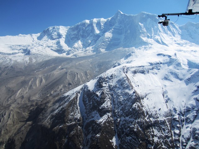
First, Captain Maximov and Avia Club Nepal have been exceptionally helpful in providing more information about the landslide. The following three images are used with their permission but are copyright of Avia Club Nepal. The first shows the landslide as it occurred. The slide is clearly generating a huge cloud of dust – this is an important observation in terms of our interpretation below (note that we have rotated and cropped this image to get the best possible view of the landslide):
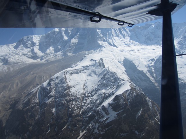
These two images show the deposition area of the landslide. They were taken a few days after the event:
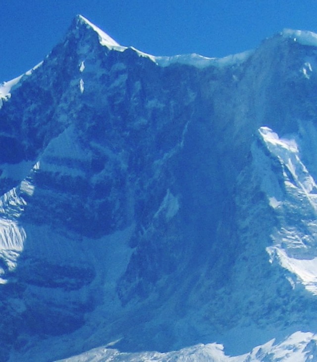
Whilst the obvious feature in these images is the large depositional zone on the surface of the lower angled slopes, if you look carefully you can see that on the steep slope behind there is a scar on the mountain side that extends to the ridgeline. We have zoomed in on this area in the image below, and have tried to change the contrast to show the feature more clearly:
Note in particular the section of the snow cornice that is missing in the top right side of the image. Once you have seen this the fresh scar is really very clear. So it is clear that the landslide is a huge rockslope failure – note that this cliff is about 2000 m high, on the flanks of Annapurna IV. The mass appears to have fragmented when it reached the lower angled slopes at the foot of the steep section, and to have runout as a rock and debris avalanche.
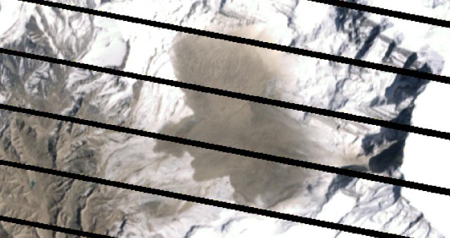
To better constrain this phase of the landslide, we have been working with Michon Scott of NSIDC, and Robert Simmon and Jesse Allen of NASA, who have been kindly collecting satellite imagery for us. They will be posting a summary of their work on the NASA website shortly (and I will update this post to provide a link), but their help has been invaluable. The best image was collected on 6th May by the Landsat ETM+ instrument. Unfortunately there are technical problems with Landsat that mean that the images have missing data, which generates the tiger-stripe effect that you can see below. However, the data quality is fantastic, such that the jey features of the landslide are quite clear. So here is the unannotated image, and below we have included one that highlights the key features of the landslide:
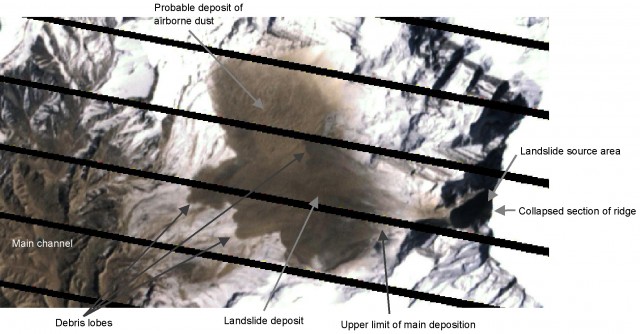 So, as shown above our interpretation is that the landslide consisted of a main detachment event from the steep 2000 metre high rock slope flanking Annapurna IV. This rockslope failure had a volume of about 22 million cubic metres. At the toe of the steep slope the mass fragmented and transitioned into a rock avalanche that flowed down the very steep slop. As the gradient started to decline deposition was initiated. The landslide generated a series of flows – based on previous events it is reasonable to think that there may have been a series of collapses following the main event that generated some of the lobes seen in the imagery. The fragmented mass generated a huge volume of dust, which was carried northwards by the wind to form the large aeolian deposit shown in the image above.
However, there is one remaining oddity that we have yet to resolve fully. The image above shows that the landslide did not reach the main channel – indeed even the most distal lobe is some considerable distance from main channel. So how did the landslide generate the huge debris flow that travelled down the main channel? At the moment we can only speculate, but the most likely explanation is that a small proportion of the debris entered and then flowed down one or more of the steep gullies that descend about 2000 m to the main channel. The most likely candidate is visible in the Landsat ETM+ image:
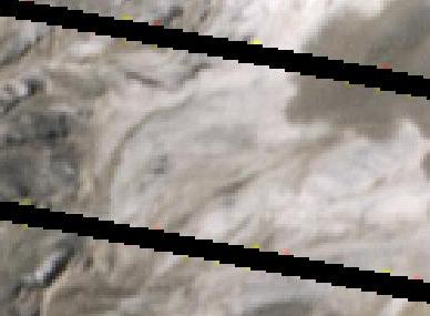 Again, we have annotated the image below for clarity:
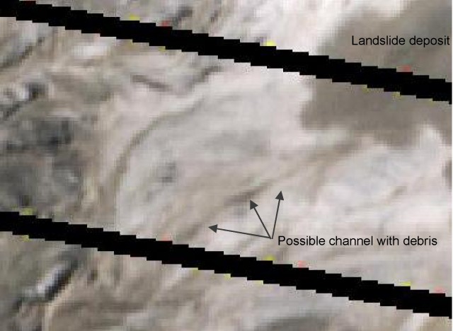 We have highlighted the most likely candidate gully, though close inspection of the image shows that there are other candidates, and it may well be that the flow travelled down several gullies at the same time. So, we hypothesise that a small proportion of the landslide travelled down the gully system, and entered the main channel at high velocity. This would then have entrained debris and fluid to create the destructive debris flow that claimed so many lives.
Finally, on 20th May NASA also imaged the Seti River from the landslide source (now covered in snow) down to Pokhara using the ALI instrument:
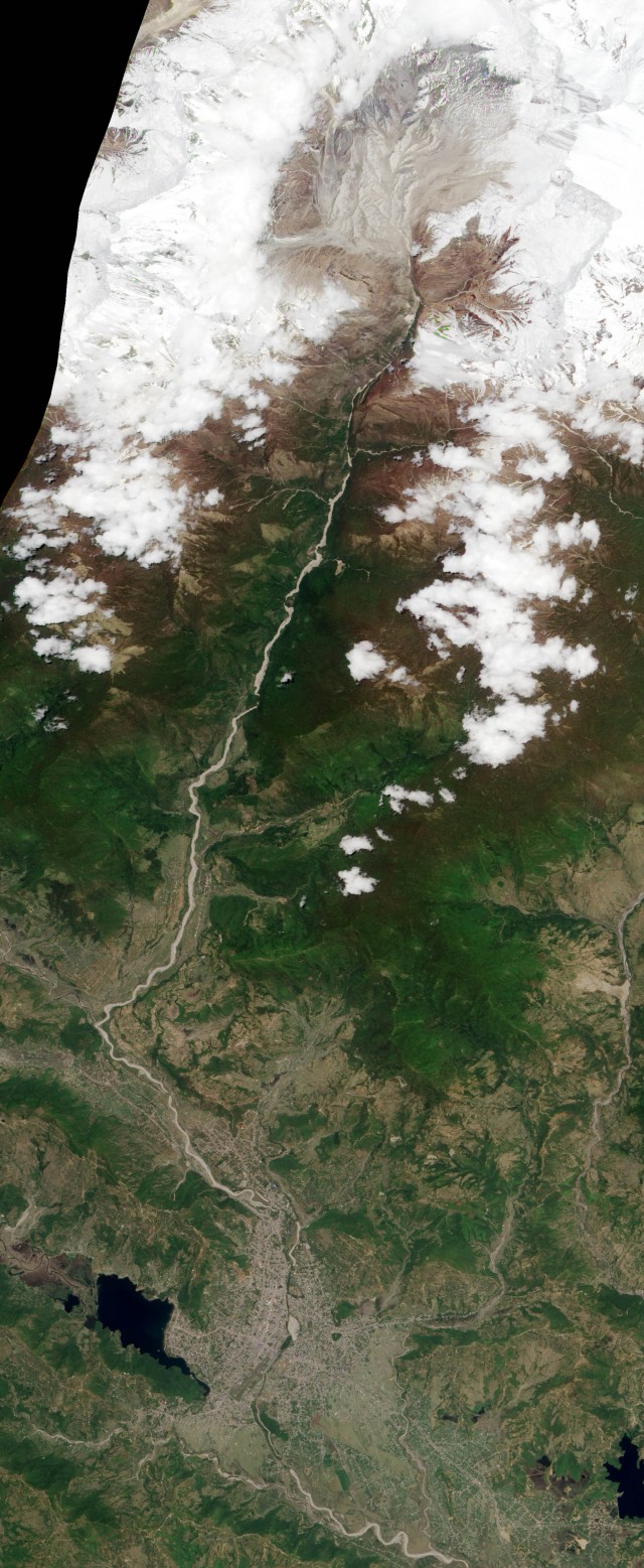 The enormous erosion and deposition caused by the debris flow along the channel is clearly visible right down to Pokhara, the town that is visible at the bottom of the image.
We have more work to do on this landslide, but as you will see from the above we now have a quite good understanding of it. We would welcome your comments and thoughts.
An interesting point to note is just how closely the analysis of the seismic data is to our interpretation of the seismic data is to the actual event as shown in the imagery. The power of this technique is becoming clear.


 Dave Petley is the Vice-Chancellor of the University of Hull in the United Kingdom. His blog provides commentary and analysis of landslide events occurring worldwide, including the landslides themselves, latest research, and conferences and meetings.
Dear Dave,
[my comments are in square brackets – Dave]
I have been following your text from the time you started to post on Seti River Disasters in Nepal. We are also still under various speculations, but we very much differ from what you have been interpreting. We recently visited the disaster-hit area and flew close to the possible snow avalanche area, which you are referring to a ‘landslide’ or a ‘rockslide’, with the same pilot who saw the smoke could on the day of disaster itself. We saw that:
1. There are no traces of landslide damming in the upstream, but the gorge is so deep that nothing can be seen from the sky and it is possible that the damming occurred in the gorge itself due to debris deposit that came from the avalanche source. However, the time difference between occurrence of the avalanche and arrival of the derbis flood in Kharapani area, the place where a village was buried and a few foreigners were also killed, is very evident that no landslide damming and its bursting could be so devastative in merely 40 minutes. You probably have noted that the avalanche occurred at around 9:00AM (please watch the video availed by Avia Club Nepal, which seems to have been taken by the Russian pilot a little before 9:00AM, 5 May 2012), and a photo taken by picnicking college boys at Tatopani area (Kharapani Area) at the time the debris flood arrived here indicates that it was taken at 9:38AM. It is more than evident that the debris flood travelled about 20km (elevation difference: about 1,800m) in about 35 minutes, which is a very justifiable speed of a debris flow. So, the story that a landslide occurred in the upstream or a rockslide occurred at a hight of 6,000 or 7,000 meters (as you have interpreted here) and it blocked the river to store a huge amount of water that later converted into a massive debris flow sounds ridiculous to us.
[Indeed – our interpretation is that the rock avalanche directly transitioned into a debris flood. We do not invoke damming of the valley].
2. The aerial survey we conducted over the Seti River source area, where we could see various amazing things, for about 30 minutes revealed that there are no traces of rockmass failure, mainly because if it did take place, we could have seen a few rock pieces (boudlers) in the area. All that 2000 m rock slope (according to your recent interpretation) cannot immediately turn into pieces and dust. What we could also see on the slope were traces of debris movement, but we guess the debris currently on the slope is because there are numerous small galciers that transport debris from the upper slopes; in a sense that snow or ice deposit on these slopes are often mixed with debris. So, our image analysis (photographs as well as video) shows that there was no massive rockmass failure as speculated by you and misappropriately evidenced by the interpretation of a photo provided by Avia Club Nepal. Please note that we have also received the same photo from them together with one more photo, which was taken on 4 May 2012. The one you have used here was taken on 7 May 2012. Although the angles of these two photos are different, a close comparison indicates that the possible landslide failure (rockslide failure), as interpreted by you, can be seen on both these photographs (I can provide you the photo of 4 May 2012 if you wish). This means the slope identified by you might have failed much before the 5th May disaster event.
[But a scar is clearly visible in both the satellite imagery and the airborne photos. Rock avalanches frequently leave almost no debris on the surface across which they flow – there is a huge amount of literature on this].
3. The chances of sesimic cause for triggering the avalanche cannot be totally denied, but we guess the avalanche was a regular process and this time it triggerred a massive failure which was prepared by long-term deterioration of slope surface material. Definitely yes, we also agree that a tiny earthquake might have also been a triggering factor of snow or debris avalanche.
[Again, this is a complete misinterpretation of what we are saying. To be clear the landslide WAS NOT triggered by an earthquake. It was sufficiently large that it was detected by the global seismic network. Inversion of the data allows the dynamics of the landslide to be analysed, and Colin and Goram correctly described the nature of this landslide fusing the seismic data before we had seen any images at all]
What we speculate:
Based on the available pre- and post-disaster photos (we are also yet to analyze satellite images), we assume that the story of a massive avalanche is true, but it was not only a snow avalanche but also a derbis mixed snow avalanche. Falling off a height of about 2,000 meters, the slid snow (ice pieces) and debris, which might have been close to melting point produced frictional heat leading to sudden slurrification, probaly within 5-10 minutes. In the valley bottom (about 2500 m), the debris mass also hit huge debris-ice peaks, some of which can still be seen from the sky, which also increased the slurrified debris mass. We can see destroyed tree trunks in mass near the confluence of Seti river and its tributory at an altitude of 2,800 m. We suppose that it happened because the debris slurry hit the standing trees. We can also provide you this photo for your reference. Were it simply a dry debris fall or debris avalanche, it would not have happened and if it did, we could have seen some debris deposit near the tree trunks. We also guess that millions of cubic meters of debris slurry was transported in this event, but by the time it arrived in Pokhara city area, we could only see muddy flood water mixed with fine silt, which is generated at the source of Seti River itself. Our photos indicate that the material in the Seti River source point and its downstream near Pokhara is the same.
[The evidence that you cite is entirely consistent with our interpretation]
Although much of it is still a speculation, we are probably sure that a rockslide or massive landslide cannot be the cause of this disaster. The interprtation made by ICIMOD is also completely wrong because the point identified by them as a landslide and landslide dam is not a recent landslide. Most interestingly, Seti River does not have much water (on 18 May 2012, we estimated at Kharapani by thumb rule that it had some 7-10 cumec waterflow, which was obviously not more than this on the day of disaster, and it might have been much less than this in the upstream). So, we cannot expect so much of water to have been stored by a landslide dam in just 5-10 minutes or say 15 minutes. Although, there are rumors that the villagers also noticed some reduction in flow of water in Seti before the disaster, there is no authentic version of this rumor. If it were dammed up somewhere in upstream, we could have seen some traces.
[I agree that the ICIMOD interpretation is not correct]
The reason why there were 7-8 waves of flood may be damming up by derbis-mixed ice mass and gradual melting or occurrence of avalanche for a few hours.
[Or this is the debris flood behaving in a normal manner. Pulsing behaviour is quite common]
I repeat this is our version of interpretation which strongly differs from your ideas. We feel that you are disseminating some wrong information in this particular text. If you have the photo of 2012.5.4 provided by Avai Club Nepal, please compare the same part of the slope in both photos. We also look forward to your another interpretation of NASA images.
Thank you.
Netra Prakash Bhandary (Dr.)
Ehime University
Japan
Dear Dave
This is Ranjan. I visited the site on 18-19th May. I found that your interpretation is wrong. Please write me email, we can discuss the issue. Meantime, Nepalese press is misinformed by your blog text, which needs immediate stop. As you know, Nepalese press prefers to refer to foreign experts as usual. So, please visit site personally or lets discuss. When you visit site by yourself, you will find your interpretation is wrong.
Thanks.
Best
Ranjan Kumar Dahal, Tribhuvan University
[email protected], [email protected]
Dear Ranjan ji
Interesting to read your comments in respect to Dave’s interpretation regarding to the cause of May 5 flood in Seti River in Pokhara. As you have said that you have also visited the site. Will you please share what are your findings? I also read Dave’s blog and believed in it like others, because I did not know about other findings. So if you shared it, the readers will be well informed.
Regards
Gehendra B. Gurung
Practical Action Nepal Office
[email protected]
can you explain pdf what is land slide and mechanism of landslide and process and impact on agriculture of the landslide?