
1 January 2021
The scale of the Gjerdrum landslide: a helicopter video
Posted by Dave Petley
The scale of the Gjerdrum landslide: a helicopter video
Tonight there is news that a body has been recovered from the site of the Gjerdrum landslide in Norway. This comes after search teams were able to access the site today to undertake the search for the missing people. With the discovery of a victim the number of missing people is now nine; there is still some hope that they might find survivors, but hopes are clearly fading given the combination of the weather and time.
I have often noted that people who have not been involved in these sorts of accidents find it hard to understand why rescues cannot occur more quickly. In part this is of course the need to protect the rescuers – there are many documented examples in which secondary landslides have cost lives, sometimes of those brave people involved in the rescue operations. But this is also because the scale of the affected area can be very large, meaning that the search process is difficult.
Both of these issues are in play here. This landslide site is very big indeed. Yesterday, NGI released a helicopter video taken of the landslide site. The video is quite long, but I recommend watching the whole thing. You will see that the landslide extends over a large distance, and is wide as well:-
.
The image below shows just a small part of the landslide mass that needs to be searched. Bear in mind too that the material is extremely weak, so moving around it will be very challenging. And of course at this time of year daylight in Norway is fleeting:-
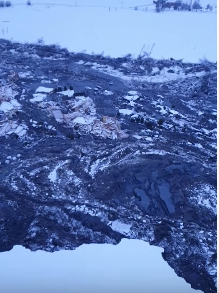
A small part of the Gjerdrum landslide in Norway. Still from a video posted to Youtube by NGI.
.
Meanwhile, in other news:
- The search, which is being assisted by experts from Sweden, has been suspended for the night as it is too dangerous to work on the site in the dark;
- Small landslides are continuing to occur on the margins of the failure, with more properties likely to be lost;
- There are some reports that a second dog has been rescued from the site
Of course on these occasions our thoughts must go to those who are missing, and to their families – for them this will be unbearable. But also spare a thought for the rescue teams and for the technical experts who are working with them. They will be under immense pressure as this continues, in the full glare of the media. There are many victims of these events, some less obvious than others.
 Dave Petley is the Vice-Chancellor of the University of Hull in the United Kingdom. His blog provides commentary and analysis of landslide events occurring worldwide, including the landslides themselves, latest research, and conferences and meetings.
Here is a link to the video of the Zajka being reunited with her family after being rescued from the Gjerdrum landslide in Norway. The 10-year old Dalmatian was rescued yesterday and only has a minor injury to her paw. Warning tearjerker alert!! The link also has the full story in Norsk about her rescue.
https://www.nrk.no/norge/familiehunden-_zajka_-_10_-reddet-fra-skredet-i-gjerdrum-1.15308569
The actual affected area is massive, much larger than the outlined area in your previous post. What causes quick clay slides to move so much material, so quickly?
Quick Clay consists of a clay like sediment that is bound together into a solid by Salt. As the salt gets slowly leached out over centuries it slowly looses it’s ability to stay solid, when the salt concentration reaches a critical low level complete failure occurs, and the entire mass essentially liquifies.
There’s an amazing mini (20 min) documentary about the Rissa slide that goes into detail about how it happens. https://www.youtube.com/watch?v=3q-qfNlEP4A
Quick clay slides results from the conjunction of the strain-softening characteristics of sensitive clays and of the mechanism of progressive failure. More detailed explanations along with 2-D simulations of these large landslides are presented in a paper by Wang et al. (2020).
Wang, C. et al. 2020. Effects of geometry and soil properties on type and retrogression of landslides in sensitive clays. Geotechnique: https://www.icevirtuallibrary.com/doi/abs/10.1680/jgeot.20.P.046
This is shocking, the area covered is vast.
A Norwegian broadcaster is reporting that a survey in 2005 found that the area was at “high risk” of clay slides. Many of the homes were built in 2008. https://www.bbc.co.uk/news/world-europe-55516599
As was the case with the Oso Landslide in Washington State (USA), residential debris (and the bodies it may contain) can be carried great distances from where it started. Such a disaster in such rotten weather…..
PS: the dynamics of this failure are truly remarkable. It turned into a slurry and split at least once as it followed the topo downhill. Hard to gage distances; at least several km travel?
The area at the top of the slide has quite a few large structures fairly close together. Could their combined weight have contributed to the collapse?
[It is a good question. In general for a slide of this size the additional weight of the buildings probably has a marginal effect. This is because of the density of earth materials, which give a landslide of this size a huge mass. I suspect that we’ll find that disturbance somewhere on the slope triggered the chain reaction of the weakening of the sensitive clays. D.]
The weight of the buildings may not be huge, but it was also added material (sand + dry clay) to the site before building. Before building, an infill was made on the eastern side in order to stabilize the hill; however, the landslide went in the southerly direction). See link below (note that the map in the link below is turned 90 degrees clockwise, so North is to the right).
https://www.nettavisen.no/okonomi/nye-dokumenter-viser-at-ngi-ga-klarsignal-til-bygging/s/12-95-3424069168
Since the are with buildings is just a small part “upstream” of the total landslide, it doesn’t seem likely to me that the landslide was initiated here (note: ‘m not a geologist!). I guess it seems most likely that the landslide started somewhere at the bottom of the forested hillside (south of the buildings), leading to the collapse of the forested hillside when the clay went liquid (i.e. a typical retrogressive quick clay landslide), and the part of the hill with the houses collapsed as its “foundations” to the south disappeared. When the houses were built, a local hydrologist had expressed that he was worried about erosion along the creek running N-S at the bottom of the hill, due to changed hydrology (deforestation etc.).
Curious of the Rissa slide (video link above) question of how the “springs” played a role in the slide. The video suggested, springs appeared from the slide exposures, which tells me springs existed prior to the slide. Curious to number of springs, quantity of water springs produced. Learned much, thank you.
Don’t know if anybody will read this, but here is a final update, as we mark two years since this tragic incident that took the lives of 10 people and an unborn child.
– While seven of the deceased were found relatively quickly after the landslide, Ann-Mari Olsen-Næristorp and her 13 year old daughter were found 9. February, and Rasa Lasinskiene (who was walking the dog when the landslide happened) was found at about 1 meter depth on 22. March
– The report on the causes of the landslide was released 29. Sept. 2021:
https://www.regjeringen.no/no/dokumenter/arsakene-til-kvikkleireskredet-i-gjerdrum-2020/id2872948/
It’s in Norwegian, but the conclusion was that the minor stream Tistilbekken at the bottom of the valley had over several years been digging into the ground (figure on page 10). This caused a small area of clay to collapse into the creek (marked 0 on the map on page 11), about 400 m downstream from the housing area (7 on the map)
– When the housing area was built, the area was checked for unstability, and efforts were made to stop erosion around the stream in the northern area. However, the rules at the time did not say that one had to check stability and stop erosion as far away as where the landslide started
– the micro landslide into the stream (stage 0) uncovered unstable, “liquidizable” clay uphill, which caused the already very unstable uphill part to collapse (stage 1, see map on page 34). A witness saw the forest “fall straight down” a few minutes after he had a telephone conversation at 3:48.
– stage 1 lead to high, unstable edges, causing stage 2 of the landslide, which caused the electricity outage in the area at 3:56:45
– in stage 3 and 4, the landslide spread north, including a forest which slid 3-400 meters on the liquid clay underneath the top, stable layer. Stage 5 took the main water pipe to the area at 03:58:40 (2 minutes after stage 2)
– Stage 7 was the housing area Nystulia. The police received the first emergency call at 3:59
– Neither making of the golf course or a local landfill was found to have caused or affected the landslide
– In February 2022, the Gjerdrum municipality (the local authorities) was charged by the police for not acting on the risk in the area, although they got several messages/letters from concerned locals during the years. In particular, a hydrologist was asked by locals to look at the area 13 years before the landslide. He sent pictures of the steam to the municipality and had a meeting with them. This led the municipality to commision a report from the consultacy Asplan-Viak which recommended to also secure the stream in the area where the landslide started. However, this was not done. The pictures of the creek can be seen here: https://www.nrk.no/osloogviken/gjerdrum-kommune-siktet-etter-leirskred_-varsler-stotter-politiet-1.15839664
– In November 2022, the police dropped the charges against Gjerdrum municipality, saying “no criminal offence can be proven”