7 February 2014
The Seti River debris flow in Nepal – what was the role of the smaller landslide downstream?
Posted by Dave Petley
A reminder about the Seti River debris flow
In May 2012 a debris flow swept down the Seti river in Nepal, taking 72 lives and causing considerable damage. Long term readers will remember that a day after the debris flow I suggested that there might be a landslide cause, and that a few days later, thanks mainly to help from Colin Stark, we identified that a large landslide was likely to have been the trigger. Over the next few days, and thanks to help from numerous people, we pieced together the the sequence of events. Although there were those that disagreed with our interpretation at the time, our initial analysis has subsequently proven to be correct. This does make it somewhat galling to see a NASA article entitled “One Scientist’s Search for the Causes of the Deadly Seti River Flash Flood“. One scientist? Not at all – this was a huge team effort.
Anyway, an interesting aspect of that article, by Jeff Kargel, is the suggestion that the debris flow was caused by a secondary landslide downstream that had blocked the valley, creating a lake. In this theory, the rock avalanche that swept down from the flanks of Annapurna IV triggered the breach of the landslide dam, releasing the destructive debris flow. The NASA article maintains that this was a significant factor:
However, the more we searched, the more it became evident that this was definitely not a GLOF, but was caused by a rockslide into the Seti River gorge, formation of an impoundment reservoir over a several week period due to damming of spring snow and ice melt, and then the final triggering event of the mighty rock and ice avalanche off Annapurna IV.
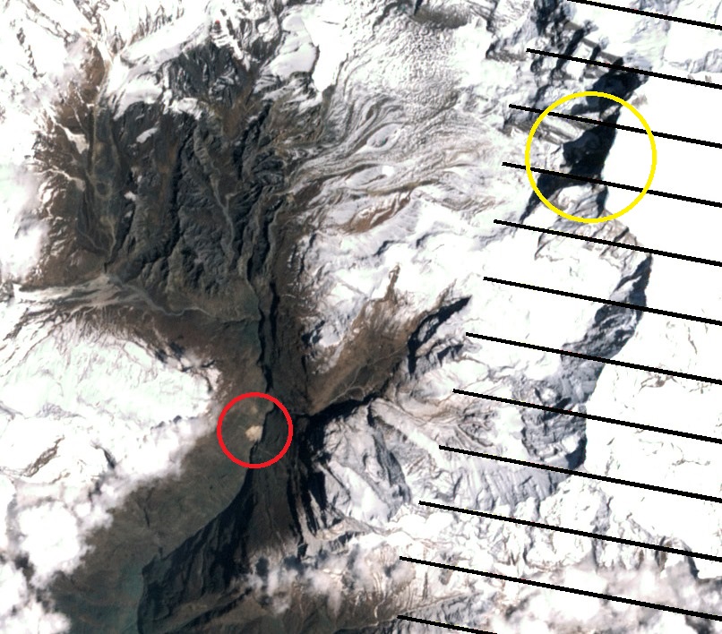
Odd wording given that we had already clearly shown that this was not a GLOF, but there you are. Anyway, does this idea of a landslide dam being the source of the water and sediment stack up? Well, the first thing to note is that this landslide was certainly present in the gorge. The scar is visible in the Landsat 7 ETM+ imagery that NASA collected a few days before the landslide, and an image taken a few days before the Seti River debris flow also shows it clearly. This is the image collected before the rock avalanche:
I have highlighted the landslide in red on the image above – it is clearly visible. For reference the cliff that collapsed to generate the initial rock avalanche is the area highlighted in yellow. I’m afraid that in my view the evidence supporting the idea of a landslide dam and lake runs out from this point.
Kargel’s idea is that, as we identified, the rock avalanche sent a proportion of debris down the very steep gullies into the main channel. This debris then caused the failure of the landslide dam, generating the debris flow. The above image was collected on 20 April 2012, about a fortnight before the rock avalanche. Colin and I looked at this imagery at the time, and we maintained that there was no need for this smaller landslide to play a role. I retain that view.
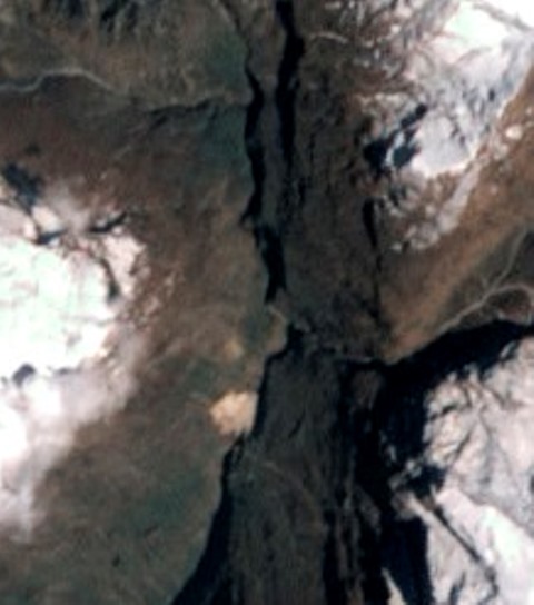
The first problem that I have with the Kargel model of a valley blocking landslide theory is the lack of evidence for a lake in the satellite imagery. Lets zoom in to the section just upstream of the landslide itself – again this is the 20 April 2012 (i.e. before the rock avalanche) image:
..
Of course we get into resolution problems (hence the blurred nature of the image), but I see no evidence at all for a water body upstream of the blockage. Perhaps it is hidden in the shadows, but if so it could not be a very substantial body of water, surely?
The second problem I have with this is that for a breach event to release a catastrophic debris flow we should see a huge breach scar in the landslide debris – remember that this is a catastrophic collapse event. Well, Dhananjay Regmi has a presentation online that includes a helicopter image of the landslide:
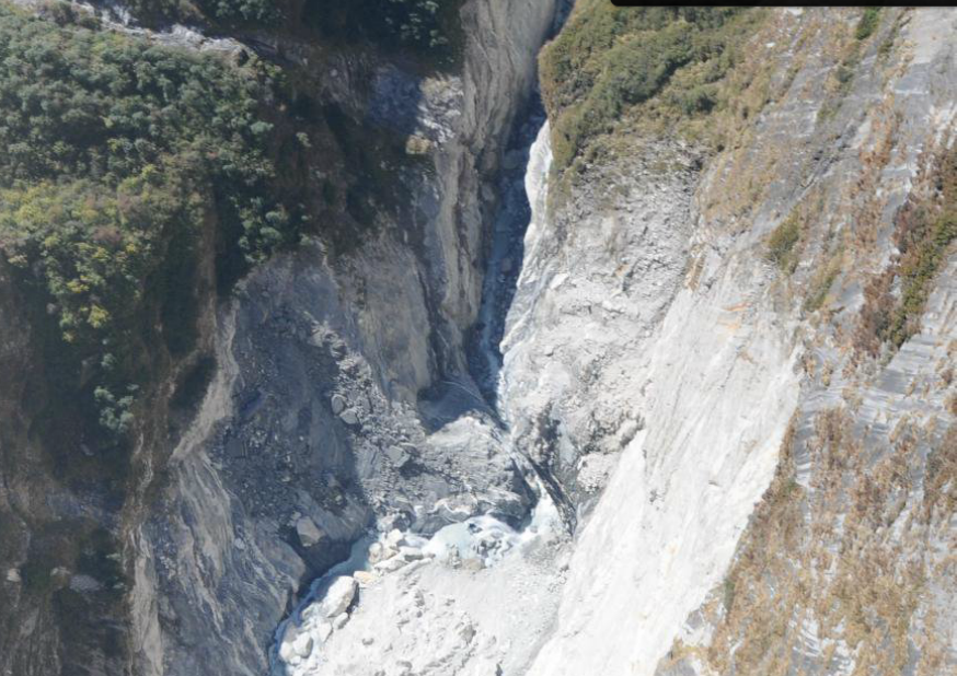
Dananjay Regmi: http://issuu.com/johnharlinmedia/docs/regmi_investigationsetiriverdisaste?e=7165924/4998805
..
To me this does not look like the aftermath of a catastrophic breach event. Maybe there has been post-breach modification of the channel? But actually there is no evidence of lake deposits in the image either.
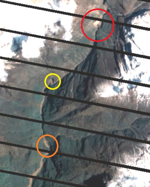
The third aspect that I find hard to understand is the downstream morphology of the channel in the post-debris flow NASA image. This is the view of the channel downstream of the landslide a few days after the Seti River debris flow:
I have highlighted the landslide in red. There is a key point to understand about landslide dam breach events. This is that the flood wave should be at its largest at the dam crest. As the wave passes down the channel from that point it attenuates – reduces in height. So, the impact should be at its maximum immediately below the dam, and this should steadily diminish downstream. Does that happen in the image above? I hope that you can see that the exact opposite occurs. The impact on the channel clearly gets larger and wider downstream – compare just below the landslide with the yellow circle – downstream the flood has clearly become larger, and even more so by the time it reaches the orange circle, and it gets even bigger thereafter. This is not a dam breach flood. Actually, this is the signature of a debris flow that is accumulating volume en route down the valley.
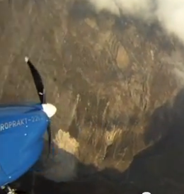
Still don’t believe me? Well, OK, I’ve saved the best for last. You see when Captain Maximov videoed the rock avalanche he also caught this smaller landslide in the film. He captured an image of it on his first orbit, which is about the time the landslide started. This is a still from the video:
The landslide is directly below the nose of the plane, upstream is to the right. There is no lake, even though this was taken as the rock avalanche initiated..
So what happened? The increase in size of the debris flow scar downstream suggests that the debris flow was entraining its bed (over-running and incorporating river bed sediments) as it travelled downstream. This is a very well-established process in debris flows, and it is not exotic.Most importantly, it explains all of the observations outlined above.
So the downstream landslide did not play a major part in this tragedy, and this was not a dam break flood.


 Dave Petley is the Vice-Chancellor of the University of Hull in the United Kingdom. His blog provides commentary and analysis of landslide events occurring worldwide, including the landslides themselves, latest research, and conferences and meetings.
First point. While I very much make this blog a part of my week/day, I prefer my science without interpersonal snark. The title of the NASA blog could easily be construed as one person’s personal story of how researching the event unfolded for them (in the field) and not an implicit or explicit remark about how only one researcher actually “discovered” the truth. Further evidence for this is the clear acknowledgment of the landslide blog and Dr. Petley at the end of the NASA post.
Second, I do not find any of the remote sensing evidence presented in this post compelling. The gorge in question is extremely incised (very narrow and deep) and could be hiding some amount of landslide impounded water that would be barely visible in the majority of aerial imagery. I can’t see the bottom of the gorge in the “best for last image” or any of the other images. The argument about the large flood wave impact at the dam crest only makes sense if the topography in the second to last image is consistent down gorge. No topography is presented in this post. If the gorge is much deeper and narrower at the point of the smaller rockslide (yellow circle) and widens downstream, then the pattern of destruction of vegetation on the sides of the channel would be expected to be exactly like that shown in the image. I do think there are good points raised, but I still wonder where the water came from if there wasn’t a displacement wave and there wasn’t enough frictional heat from the large rock and ice avalanche to generate an abundance of water. I don’t think this can be conclusively answered from the remote sensing images presented so far. If anything, this is an argument for on the ground investigation in an area very difficult and dangerous to access.
Dave, so far as the galling aspect goes, that was never my title. That was created by the Earth Observatory, and the posting went really fast. In fact,my whole report was prepared and posted in about 48hours, when EO contacted means I had other deadlines to meet that day. I am not complaining, just noting that things don’t always go according to the best path when everybody is under pressure from many angles. So far as the lake is concerned,I’ll present evidence for the lake. We have good evidence, but we need to put it all together. Soon. But I definitely want to leave room that other sources of water may have been involved, as you may also infer from my earliest posts via ICIMOD. You’re right, as any reader of that post will discern, it was a large team effort, not one scientist. I think EO intended the title in a different way, that it was one scientist writing,which it was. It was a big team effort, and remains so.
Dear Eric, our Nepalease colleagues of Dept. of Mines & Geology and me were deeply concerned about the hazards and risks in Pokhara Valley since we studied the geological history of that area with much detail (Koirala et al. 1996: Engineering and environmental map of Pokhara Valley, and several papers meanwhile). We had planned to study the source area of the historic and pre-historic giant debris-flow events in the inaccessible Sabche Cirque but did not get the funds. We are rather obset now that the field studies done by Jeff and his team come to such poor results just confirming the speculations expressed already during the HKT Workshop 2012 (see Regmi et al.). The key crux in the explanation of the origin of the huge water volumes by Jeff is that the temporay landslide dam could only explain the very first surge. In our paper, Hanisch et al., J.Nep.Geol.Soc. 2012, we have discussed the various possible origins; especially the enormous energy dissipated during the huge rockfall of 15 or 22 Million cbm (in the Alpes this would be called a “Bergsturz” = mountain collaps) should have been able to create enough impact and frictional heat on the glacier at the toe of Annapurna IV (compare the high-resolution images in Google Earth of March 24 and November 4, 2012).
But let us wait for the final report of Jeff.
Joerg (Jorg– Iam not sure your preferred spelling; I see it differently in various places), we will consider your model very carefully and respectfully.This was one of the first calculations I did back in May 2012, and at that time I found this heat tone an interesting number but not sufficient. Furthermore, I have very good evidence that this–or some source of liquid high of in the system– was at play, but so far it has been our assessment that it is insufficient. However, we will look at our input values (and your numbers, too, citing them as needed of course), and assess it freshly.If we arrive at your conclusions, we’ll credit you. Don’t worry about the crediting thing. If we retain our present view that it is an insufficient amount of energy (and we have to consider the partitioning of energy, too), then we will respectfully disagree, and very respectfully cite your views and calculations. Likewise, Dave doesn’t need to worry about who gets what credit for saying which things when. Dave will get his due credit. Of course it will also be made clear when I was on the site, when reports were issued. To me it’s not a game of who gets the greater glory and trying to make that be me. Believe me, my team colleagues had more reason than you or Dave to be “galled” by the title of the EO release. But viewed objectively, does it matter? Reality is evident regardless of a poorly worded title. Of course we all want to get things as right as possible, and that would include the references and credits, of course, even if it is merely a PR blog. OK, so we all can each do better in this regard. The more important thing is talking to people,and of course officializing/publishing our scientific ideas,which I am slow to do but will get the job done.
…and sorry for my sticking spacebar + autocorrect…. maybe you can read through my typos!