15 February 2012
Background to the Tumbi Quarry landslide – so how can a quarry cause a landslide?
Posted by Dave Petley
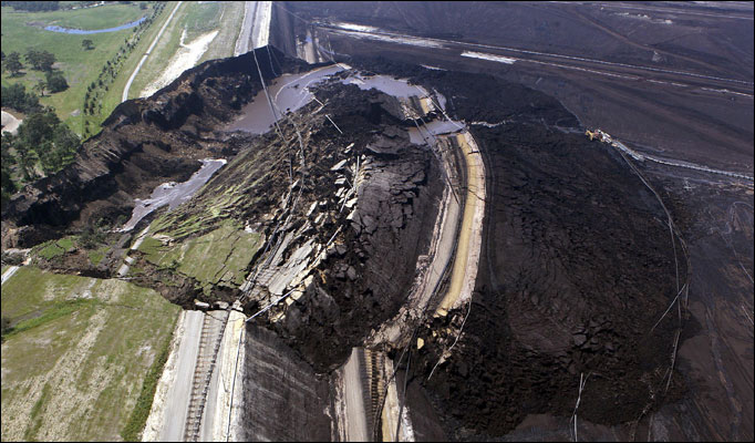
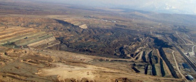
A question that has arisen a few times about the Tumbi Quarry landslide in Papua New Guinea is why it is that a quarry can increase landslide occurrence. The first point to be made is that many quarries, when properly managed, do not cause slope instability. However, some of the most spectacular landslides are caused by mines or quarries. Two come immediately to mind – this is the Yallourn open cast mine landslide in Australia (I have never seen one like this anywhere else!):
And this (courtesy of Caner Zanbak), is the Collolar lignite mine landslide in Turkey two years ago:
So why do quarry walls fail? There are many reasons, but the most important include:
- Almost always the quarry walls are cut more steeply than the existing slope. If this slope is too steep for the rocks in question a slip can develop;
- Cutting the slope sometimes “daylights” (exposes the toe of) an existing discontinuity or plane of weakness, along which sliding can occur. In Collonar above it is likely that sliding occurred on a pre-existing weak layer;
- Cutting the slope can change the groundwater conditions, which can lead to pore pressure build up in weaker areas;
- Blasting the slope can cause fractures to develop that allow the release of a block;
- Cutting the slope can remove layers of strong materials, exposing weaker strata that are prone to failure.
The design of quarry walls, and the maintenance of them, is a highly specialised task into which responsible operators invest a great deal of resource. As a result monitoring of quarry wall movement is a key part of quarry operations, and many quarries operate safety systems to allow them to evacuate is instability develops. As a result, catastrophic quarry wall failures remain rare. Of course it is not clear that any of these are the case at Tumbi Quarry, but these are some of the processes that the investigation should be considering.
It would be good to have some examples of quarry or open cast mine landslides highlighted in the comments. Would anyone like to suggest an example or two?


 Dave Petley is the Vice-Chancellor of the University of Hull in the United Kingdom. His blog provides commentary and analysis of landslide events occurring worldwide, including the landslides themselves, latest research, and conferences and meetings.
Awesome pictures. Have you every looked at the China Slide in Trinity, California. Happened during the gold rush, was named after the Chinese miners who died. Recent earthquakes in the area got me to wondering about the trigger of this big one. Pictures are on line and you can see it from Google Earth.
[Many thanks, but I am finding it hard to track down more details of this one. Can you provide any more information? Dave]
A google image search of “mine slope failure” leads to a number of images with various sizes and mechanisms for failure. Some of the more famous examples include: Chuquicamata, Chile (late 1960’s) – a classic example; Batu Hiju, Indonesia; Grasberg, Indonesia in 2003. There are many others, although not all are extensively reported. Companies genreally do not want details about slope problems made public. I disagree with this stance. As with all disciplines of engineering, studying what has gone wrong before helps us to make improvements to future designs.
A google image search of “mine slope failure” leads to a number of images with various sizes and mechanisms for failure. Some of the more famous examples include: Chuquicamata, Chile (late 1960’s) – a classic example; Batu Hiju, Indonesia; Grasberg, Indonesia in 2003. There are many others, although not all are extensively reported. Companies generally do not want details about slope problems made public. I disagree with this stance. As with all disciplines of engineering, studying what has gone wrong before helps us to make improvements to future designs.
Imperial Metals, Huckleberry Mine, SE of Smithers BC, Canada, June 2007 East Zone Pit north wall failure. (2×10^6m^3 est volume). No injuries or equipment damage were reported and mine life was nearing conclusion in that pit so there was minimal loss of production. Mining is ongoing in an adjacent pit.
Bing Aerial view:
http://binged.it/wz5ZMH
Mine level view looking NE at failure head scarp:
http://goo.gl/QRyPo
Another mine level view looking slightly east of previous view:
http://goo.gl/NfG3J
BC EMPR Mines Report 2007 (view of failure toe and brief discussion of mine geology on page 6)
http://goo.gl/TcDMF
I couldn’t find a technical report on the Huckleberry wall collapse on the web.
I should have added that in the Bing view you can see that they built a dump off a haul road on the south east pit rim to stabilize the slide toe.
More on Huckleberry. This 2011 Mine Optimization PDF report discusses the geology of the mine area, including in the completed East Zone Pit. Pages 37, 40 illustrates faulting and slide location. Pages 65, 66 illustrate and describe dyke and faulting along the north wall of the Main pit, just west of the east pit.
http://goo.gl/Zvc9i
Don’t forget this EPIC FAIL:
http://en.wikipedia.org/wiki/Pantai_Remis_landslide
which I first learned about on this very website!
[…] to everyone who has submitted ideas of images of the landslides in and around quarries and open cast mi…, in response to the Tumbi Quarry landslide posts. This is a collection of images of landslides […]
[…] LNG Watch blog has posted online some new images of the aftermath of the Tumbi Quarry landslide in Papua New Guinea. This is a good time to look in a little more detail at the landslide […]
[…] readers will have seen that Reuters yesterday ran a syndicated story about the Tumbi Quarry landslide, and the implications for Exxon-Mobil, which was picked up by many mainstream media outlets (e.g. […]
[…] readers will have seen that Reuters yesterday ran a syndicated story about the Tumbi Quarry landslide, and the implications for Exxon-Mobil, which was picked up by many mainstream media outlets (e.g. […]