14 February 2017
The enormous scale of the erosion problem at the Oroville Dam site
Posted by Dave Petley
The scale of the erosion problem at the Oroville Dam site
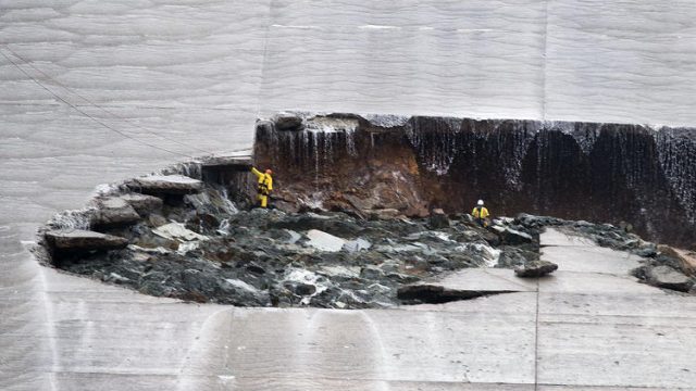
As the fairly desperate attempt continue to shore up the spillways at the Oroville Dam site, and to lower the water level ahead of the next rainstorm, better images are emerging of the scale of the problems on both spillways. If we start with the main spillway, which suffered the original erosion events last week, it is hard to appreciate the serious nature of the problems. However, this image (via the Sacramento Bee) from the weekend shows workers in the hole eroded in the main channel:-

The spillway hole at the Oroville Dam site, via the Sacramento Bee
.
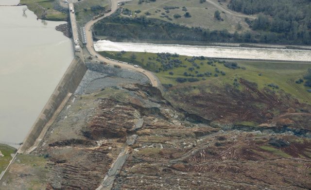
Of course the high flows down the spillway since then are likely to have exacerbated the problem significantly. Meanwhile, the headward erosion problem in the emergency spillway is now garnering most of the attention, primarily because of the potential for a major collapse. This image, from Hamodia, shows the nature of the erosion that has developed at multiple locations immediately down slope of the emergency spillway at the Oroville dam site:

Erosion below the emergency spillway at the Oroville Dam site, via Hamodia
.
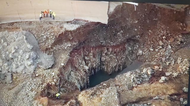
The most serious problem appears to be a gully towards the bottom of the image, but there is also substantial amounts of erosion occurring on the other side too. The danger is of course that the these gullies will suffer headward erosion until they undermine the spillway lip. whereupon collapse may occur. One challenge is that the quality of the rock does not appear to be high, which accounts for the rapid erosion in both cases. This image, via Twitter, shows the nature of the bedrock with which the crews are dealing:-

The nature of the bedrock in the spillways at the Oroville Dam site, via Twitter
.
The challenges are substantial. Fortunately, as before, there is no threat to the dam itself.


 Dave Petley is the Vice-Chancellor of the University of Hull in the United Kingdom. His blog provides commentary and analysis of landslide events occurring worldwide, including the landslides themselves, latest research, and conferences and meetings.
Very scary how close that came.
It would be interesting to know what type of ’emergency’ the emergency spillway was designed for. To me it seems like it was a structure of last resort to prevent the dam from being overtopped, not an alternative spillway to the main spillway. Why was the decision taken to use it? Was it because of safety concerns about further damage to the main spillway or was it because of financial concerns about having to pay more if the main spillway sustains further damage?
[I don’t think there was any option or choice. The water level was rising because inflows were so high and the main spillway was compromised, and so had not been used to lower the lake. In adddition there is no flow through the dam because the channel downstream is so choked. This was not a conscious decision – the water level rose until it overtopped the mergency spillway. The damage will cost a great deal to fix, so there is no saving from this event. Others may be able to provide insight too. D.]
I was under the impression that the flow rate through the gates onto the main spillway was doubled to around 100,000 CFS as soon as the erosion problem and the danger to the concrete weir on the emergency spillway became apparent – the current rate is still 100,000 CFS. I think the maximum flow over the emergency spillway was only around 10,000 CFS, which suggests to me that the emergency spillway would not have come in to play if the flow down the main spillway had been 100,000 all along, i.e. that the flow was reduced down the main spillway to protect it in the knowledge that doing so would mean that the emergency spillway would be used.
The speed of the bedrock erosion is frightening – if the concrete weir had collapsed then the flow rate and erosion over that same region would have increased drastically. The gates on the main spillway might have been in jeopardy and I don’t find it impossible to think that there was a very small risk that the erosion could have reached to the dam, even if it is a couple of hundred metres away. Idle speculation I know – it’s a fascinating and terrifying situation.
Unbelievably, the emergency spillway was apparently designed to handle 350,000 CFS! Sundays flow causing the damage shown above was <12,000 CFS. When a motion was filed with FERC in 2005 requiring armoring of that spillway with concrete, this was deemed unnecessary. An article in The Mercury News provides details and information on sources. http://www.mercurynews.com/2017/02/12/oroville-dam-feds-and-state-officials-ignored-warnings-12-years-ago/
Fantastic post. Other SoCal geologists I work with or know are fascinated by this.
The geology at the spillway looks pretty interesting as it looks to be the Jurassic Smartville Ophiolite Complex, that is well written about in John McPhee’s “Assembling California,” which follows UC Davis professor Eldridge Moores’ investigations.
Here’s a couple of online references that I found:
Basic geologic map:
http://www.water.ca.gov/orovillerelicensing/docs/DEIR_070521/06%20Ch%2004%20Env%20Setting%20Part%201.pdf
1980 paper on the Smartville Complex by Menzies et. al:
http://earth.geology.yale.edu/~ajs/1980/ajs_280A_1.pdf/329.pdf
The Daily Mail has some good photos showing what the rocks and geologic structures look like beneath the emergency spillway (in the eroded cavities): http://www.dailymail.co.uk/news/article-4221808/Officials-warned-Oroville-Dam-12-years-ago.html
(later) Looks like they “dumped” the best “geology” pictures from the original story.
(later) Looks like they “dumped” the best “geology” pictures from the original story.
Whether there is “no threat” to the dam depends on how you look at it. If the gullies on the “emergency” spillway suffer headward erosion and undermine the lip, that might well bring down the dam or a large portion of it.
To me this IS a “threat to the dam.”
[I disagree. The dam is an entirely separate structure located some hundreds of metres away. It is performing as designed. Even if the emergency spillway collapses the dam will remain intact, albeit with a lot less water behind it. Managing the water in the reservoir in this scenario would be a major problem through the snowmelt season though. This is one of the reasons why they will desperate to ensure that this does not happen. D.]
If the spillways are constructed on a sheeted dike complex, the large variances in rock type associated with this type of formation combined with faulting, folding, and low T metamorphism that occurred during obduction will result in areas of bedrock more prone to chemical weathering than others. The steeply dipping beds will enhance the downward migration of meteoric water, exasperating this differential weathering pattern. Being situated hundreds of feet above the river has left this bedrock exposed to the elements for a million years more or less and has led to chemically weathered bedrock extending far below the surface in places while inches away horizontally is fresh bedrock.
Even worse would be if the spillways are built into the unit stratigraphically above the sheeted dikes, metavolcanics intruded by the dikes. Pillow lavas with their chill margins are fragile when fresh, and are even more susceptible to chemical weathering than the dikes.
Diabase might be an incredibly strong rock when fresh, but not all of the main spillway is built directly on this competent bedrock as is evidenced by the original blowout and images of the spillways construction. There are many sections of the main spillway directly below the gates that were built on chemically weathered bedrock. With a 100k cfs flowing for the foreseeable future, with higher rates likely considering the long range forecasts, another blowout is a real possibility.
The emergency spillway is not auxiliary, and i don’t believe any competent geologist present during it’s construction would have considered its use as anything but a last ditch effort. It was designed as a fail-safe to prevent the loss of the main dam during the event of a half a million cfs inflow to the lake during a 200 to 1000 year event. The ogee weir extending from the main spillway gates was likely built to protect the main spillway gates. The bedrock was excavated deeper below the ogee weir to find more competent bedrock than the concrete wall extending northwards from the ogee weir, which was built to protect the ogee weir. The lack of concrete in the far NW corner of the parking lot where we saw considerable erosion and helicopters lowering bags of rocks into is not lack of foresight, but designed weakness built into a weak structure. The parking lot is built on highly weathered bedrock and is designed to function as a sacrificial plug located as far from the dam itself as possible, similar to the Auburn coffer dam failure of 1986. As headcutting progresses into the parking lot, water at elevation 900 and above is skimmed off. Once headcutting reaches the lake, then downcutting commences, “safely” lowering the lake till competent bedrock is found, maybe a hundred feet down, leaving the vast majority of the lake still in the lake and Oroville dam still standing, no matter the magnitude of the storm.
The costs associated with building a sound “auxiliary” spillway due to the amount of bedrock that needed to be excavated to reach the competent stuff, probably discovered after work had begun, could have led to such a design. In the event that the emergency spillway saw huge flows (not a mere 12k cfs), the flows would hydraulically mine out the weak bedrock so that a future main spillway and gates could be constructed that actually would stand the test of time. This was before water quality standards for fish was a concern.
Super analysis of the dam! I bet how you describe the emergency spillway as “…leaving the vast majority of the lake still in the lake and Oroville dam still standing, no matter the magnitude of the storm.” also applies to the main spillway so that the dam is not in danger of total failure like Susan Foley said above.
So maybe they should not have used the emergency spillway and just continued to use the main spillway letting it erode that would remove weak bedrock to make way to build it up afterwards.
[As with all hazard management it is so easy to know what to do in retrospect. The decisions are far harder in real time. No-one knew how the main spillway would perform with such damage and such high levels of flow. D.]
It looks like they’re beginning to put concrete down the emergency spillway… seeing the highly weathered subsurface of the hill, they should have done that a long time ago…