Nuugaatsiaq tsunami: details emerge of the landslide
In the last 24 hours details have started to emerge about the very large landslide that triggered the Nuugaatsiaq tsunami in Greenland on Saturday, which is now known to have killed four people, with a further nine people injured, two of them seriously.
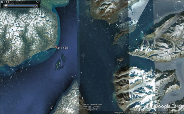
The landslide occurred on Karrat Fjord, which according to Google Earth is the area shown below (although the location is far from clear at present). Nuugaatsiaq is in the north of this image, on the plateau with the aeroplane symbol.
The location of the landslide that triggered the Nuugaatsiaq tsunami, via Google Earth.
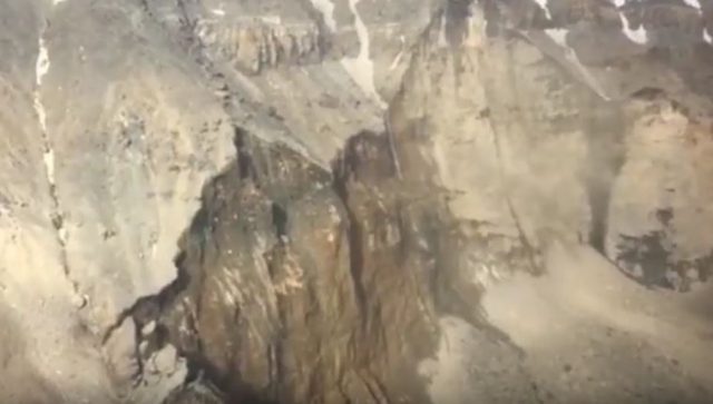
This image from the video suggests that the landslide may have been very deep-seated, and thus high volume, but we will need a better image of the slide to determine this properly:
The scar of the landslide that triggered the Nuugaatsiaq tsunami; still from a Facebook video
.
It remains unclear as to whether this landslide was triggered by the reported earthquake, or whether the seismic event was the signal from this landslide. My sense remains that the latter is the most likely, but we await details of the seismic signal to know.
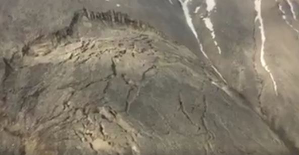
But perhaps the biggest current issue is the discovery of another potentially unstable slope immediately adjacent to the mass that has failed. This is clearly shown in the video:-
The potentially unstable rock mass adjacent to the landslide that triggered the Nuugaatsiaq tsunami; still from the Facebook video
.
Clearly there is the potential for a further large landslide from this slope (although failure is not inevitable). The plan is that one of the naval ships in the area will now keep a watch on this slope. There is a need to establish proper monitoring at this location as a matter of some urgency. In consequence the settlement of Nuugaatsiaq has been completely evacuated, and both Illorsuit and Viaqornat are being evacuated as well.
Nuugaatsiaq: A large landslide-induced tsunami on Saturday night?
Late on Saturday the small community of Nuugaatsiaq in west Greenland was struck by a large but isolated tsunami. The aftermath of this event was captured on a Youtube video that has been widely reported:
.
Information about this event remains quite sketchy, but the English language media reports indicate that four people may be missing. It appears that the local seismological bureau recorded the event as a magnitude 4.0 earthquake, with the tsunami striking a few minutes later. Greenland is not a particularly seismically-active area, and as far as I can tell this earthquake has not been recorded more widely. This, combined with the localised nature of the tsunami, suggest that the cause is most likely to have been a very large landslide, either from the fjord walls or under the water (or maybe both). News reports in Greenland (in Danish) also speculate that the cause may have been a mass movement:-
It is still uncertain what caused the devastating tidal wave that hit Nuugaatsiaq on Saturday night, says a seismologist from GEUS [The National Geological Surveys for Denmark and Greenland].
“We have some signals at our earthquake stations resembling earthquakes, but they might also indicate that a landslide has been triggered,” says seismologist Peter Voss, from GEUS. He explains that GEUS has a theory that it is a major slope from a mountain that has triggered the tide of waves:
“The slump has made a large part of the mountain collapse into the fjord and has created this wave,” says Peter Voss.
But GEUS can not conclude anything from the measurements alone…He also tells that the landslide could have been underwater, and then it will be difficult to detect.
Clearly the priority yesterday was to provide assistance to the affected villages, but news reports indicate that they will start to try to identify the source today. This is important, given the potential for a secondary failure if a landslide was the cause.
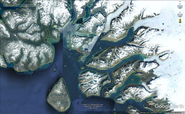
This is the Google Earth image of the area affected by the tsunami:
Google Earth image of the area affected by the Nuugaatsiaq tsunami
.
Hopefully more information will emerge about this event today.
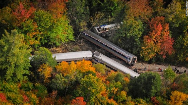
NTSB report: train collision with a landslide in Northfield, Vermont
The NTSB in the USA has posted online a brief accident report for a train collision with a landslide at Northfield in Vermont on 5th October 2015. This was a quite dramatic accident between a passenger train operated by Amtrack and a small rockslide. The collision led to the derailment of the locomotive and four carriages. One of the carriages slipped down a steep embankment; seven people were injured, four of whom were train crew. The damage caused by the landslide exceeded $10 million.
CNN image of the derailment at Northfield in Vermont
.
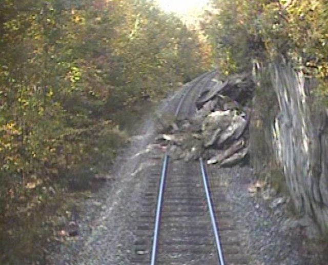
The NTSB report includes an image taken from the forward-facing video camera located on the locomotive:-
Imagery from the video camera mounted on the locomotive of the Northfield, Vermont landslide. Image from the NTSB report
.
It is notable that this is a comparatively small landslide, probably caused by a failure on existing joints or other planes of weakness. The debris appears to consist of quite large slabs, which may explain the derailment. The train was travelling at 59 mph (about 95 kph) at the time of the collision.
The NTSB report makes some interesting observations about hazard management on this section of track:
Although the NECR [New England Central Railroad] had a safety program at the time of the accident, the NECR did not have a formalized hazard management and assessment program that addressed rock slide risk management and mitigation. Although track inspectors could notate anomalies along the right-of-way, the NECR did not keep or maintain the historical data on rock slides. The NECR had neither a rockfall detection program nor a rock face program maintenance initiative prior to the accident. After the accident, geologists identified two additional NECR locations where rock slide mitigation was recommended. The NECR implemented speed restrictions for trains at these two locations.
Other than the total destruction of the Anargyroi village, the tectonic rupture caused by the lignite mine that belongs to the Public Power Corporation (PPC) generated a huge financial loss to the already ailing company.
Specifically, 25 million tons of lignite worth 500 million euros and 100 million worth of excavating machinery and vehicles were buried under 80 million cubic meters of earth. According to PPC-GENOP union president Giorgos Adamidis, the total damage, including the end of operation of the Amyntaio power unit, may well exceed 1.5 billion euros.
The landslides also caused collateral losses to the stability of the power system as it is uncertain whether the two lignite power plants of Amyntaio, with total capacity of 600 megawatts, will operate again. Even though the two lignite units were fully operational from October to April, power supply shortages might occur.
Also, the effect of the landslides might be felt by 1,700 people who are at risk of finding themselves without a job. PPC was employing 850 workers at the Anargyroi mine, while there were 500 people employed by the contractors. Also, on Friday, one day before the landslide, another 350 seasonal employees were hired by PPC to work in the facilities.
PPC is denying these claims, claiming that losses are likely to be in the order of 200 million Euros. Even so, this is an exceptionally expensive landslide.
The Amyntaiou landslide in Greece. Image by Eurokinissi via CNN
Anargyroi: an 80 million cubic metre mining-induced landslide in Greece this weekend
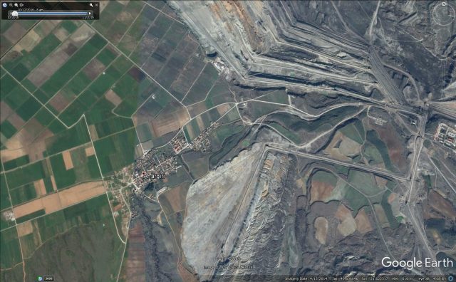
Over the weekend, the village of Anargyroi, in northern Greece, has been permanently evacuated as a result of a huge mining-induced landslide. The village, which is located at 40.603 21.612, was home to 182 people. It will now be demolished.
The landslide appears to have been triggered by the collapse of an open case lignite mine. Media reports suggest that the landslide is exceptionally large – 80 million cubic metres is being quoted by a number of sources.
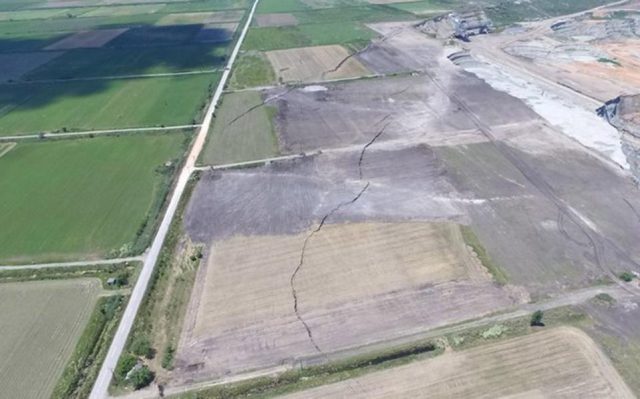
This is a Google Earth image of the village and the mine, taken in 2014:
Google Earth of the village of Anargyroi and the adjacent lignite mine
Tension cracks extending from the margins of the mine at Anargyroi in Greece. Image via ekathimerini.com
.
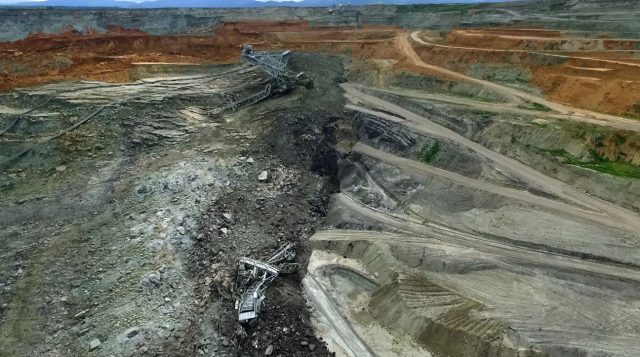
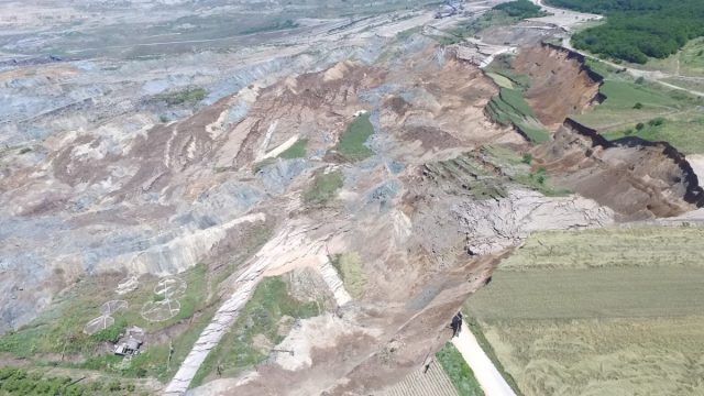
Meanwhile the best image that I have seen of the landslide itself is one the newsit.gr website, which has a fantastic gallery of views of the landslide:-
The huge mining-induced landslide at Anargyroi in northern Greece, via newsit.gr.
.
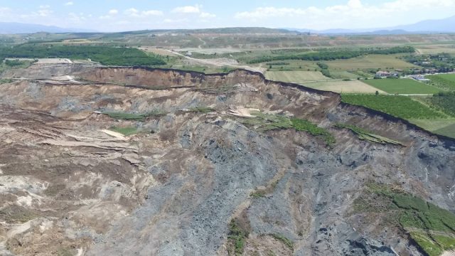
Meanwhile, this image (from the same source) gives an idea of the scale of the Anargyroi landslide:
The extraordinary scale of the Anargyroi landslide in Greece, via newsit.gr
.
A translation of the report on Newsit.gr yesterday suggests that the landslide is expected to continue for at least another 48 hours. Movements started on 3rd June, but have clearly accelerated in the last few days. This is an interesting part of the article (via Google Translate):
As a result of the landslide, cracks and damage occurred in about ten houses that are on the side of the mine front and were ordered by authorities to evacuate in order not to endanger human lives. Michalis Kavvadas Deputy Professor of Geotechnical Engineering, NTUA Polytechnic, who visited the area of the mine and the Anargyroi area three days ago, stated in statements that the movements of soils at the mine of Amynousis activate the tectonic fault that passes through the village, causing larger cracks in the streets and in its homes.
Landslides in Art Part 29: a Victorian view of Black Ven
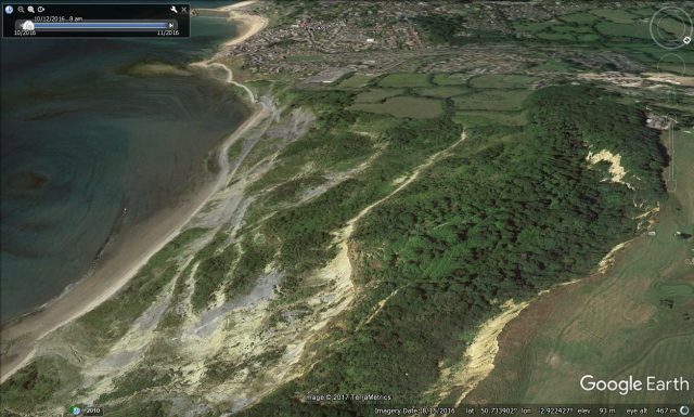
This is the latest edition of the long-running Landslides in Art series; in this edition I am looking at a Victorian view of the Black Ven landslide near to Lyme Regis in Dorset, southern England. The previous edition is here.
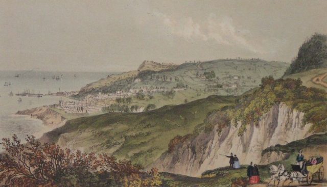
Dorset is one of the most beautiful counties in England, and the coastal landscape around the town of Lyme Regis is perhaps the crowning glory. This landscape has formed primarily through coastal landslides. The downside is of course that these landslides represent a substantial hazard, and they regularly damage houses and roads. Probably the largest landslide of all is Black Ven – a magnificent rotational landslide complex to the east of Lyme Regis.
A Victorian view of the Black Ven landslide in Dorset. A privately-owned image via the Marine Archaeology Trust
.
This is a modern Google Earth image of the Black Ven landslide complex, looking towards Lyme Regis:
Google Earth image looking across the Black Ven landslide towards Lyme Regis
.
The landscape of Lyme Regis itself is clearly recognisable in both images. As the Google Earth view shows, Black Ven consists of a rotational landslide complex. The large rotational blocks periodically slip and then degrade to form flows that pass over the benches lower down the slope. The Victorian image appears to show one of these slipped blocks on the right side, and the degraded landscape downslope from there. The apparent cliff in the foreground may well be the rear -scarp of a block that has more recently slipped. There is a couple standing on the edge of this scarp, clearly enjoying the view across the landslides. Is there just a hint of a crack between them and solid ground?
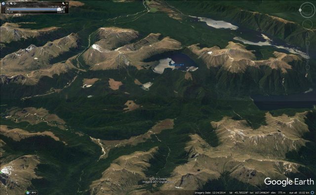
Worldwide there is a small number of landslides that a\re so large that they are almost impossible to comprehend. The Green Lake landslide in Fjordland, New Zealand, is one such example. This is a landslide that is so enormous that early mappers failed to recognise is at a slide; indeed the first proper description of the Green Lake landslide as a mass movement only occurred in 1983.
The landslide consists of the collapse of a 9 km section of the Hunter Mountains in southern New Zealand (the location is -45.78, 167.36 if you want to take a look);
The volume of the slide is 27 cubic kilometres, making it one of the largest known landslides on earth, and the largest in New Zealand;
The landslide covers an area of 45 square kilometres;
The thickness of the landslide is up to 800 metres, although there is considerable uncertainty about this figure given the lack of subsurface information.
This is the Google Earth image of the landslide as it is today:-
Google Earth image of the Green Lake landslide in New Zealand
.
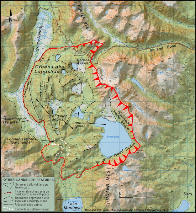
The best way to appreciate the scale of the landslide is to compare this image with the topographic map provided by Hancox and Perrin (2009):-
Topographic map of Green Lake Landslide showing its main geomorphic features. From Hancox and Perrin (2009)
.
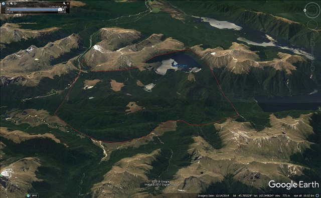
Based on this I have attempted to draw the approximate boundaries of the landslide onto the Google Earth image:-
The boundaries of the Green Lake landslide in New Zealand. Google Earth image.
.
This landslide clearly occurred after the glaciers retreated, and thus must be younger than 14,000 years old. Dating such a landslide is difficult, but Hancox and Perrin (2009) concluded that it probably happened 12,00 to 13,000 years ago. The cause of the landslide is of course hard to determine, but the glaciers had probably left the landscape in an oversteepened and thus unstable state. This part of New Zealand is subject to extremely large earthquakes. Hancox and Perrin modeled the stability of the site based on a reconstruction of the original topography, and concluded that it was very sensitive to seismic accelerations. Thus, a large earthquake is considered to have been the most likely trigger.
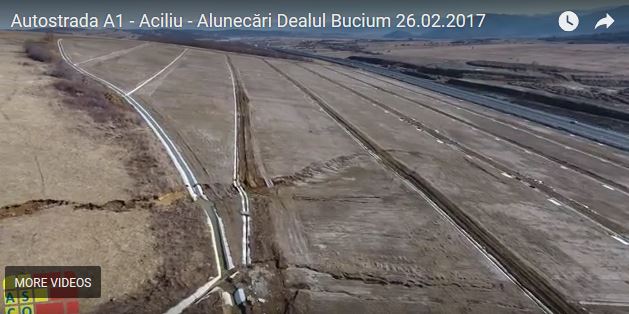
The left flank of the Bucium Hill landslide in February 2017. Still from a Youtube video
.
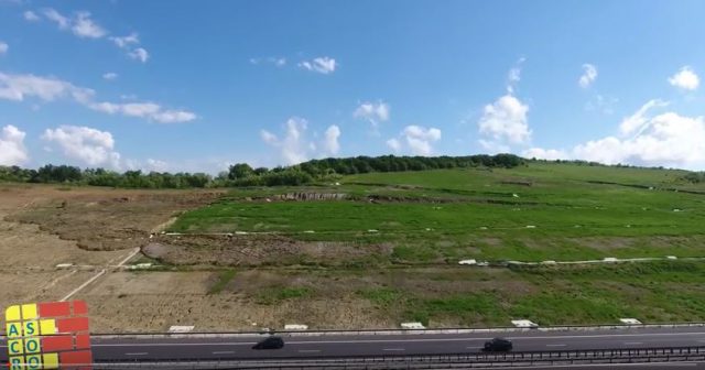
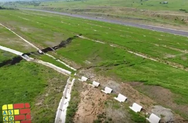
This is the same section in May 2017:
The left flank of the Bucium Hill landslide in May 2017. Still from a Youtube video.
.
The lateral scarp in this area appears to have developed further over this period, indicating that the slope continues to deform. Needless to say these broken drains and drainage channels are a problem. The drains are of course designed to remove water from the slope in order to prevent erosion and to draw down the pore water pressure. But in such cases maintenance of the drains is critical, as broken drainage channels can become a very effective conduit for feeding water into the slope in a concentrated manner. In this case, as the images show, the drains will feed water directly into the shear surface. This is exactly what one should avoid. Whilst I cannot say whether this slope is in a critical condition (I assume that proper monitoring is being undertaken to ascertain this), the need to repair these drains is undeniable.
He has provided some accompanying text (in French), a part of which states (as translated by Google):-
What you can not feel through the video are: trembling under your feet; Vibrations, which even make the air enter the lungs; The smell, a smell of mud a little sulphurous, an odour that spreads in the valley of the Rhone for one or two days; It is the feeling of being very small … there is a kind of comparative relationship that settles where I grew ever smaller and the natural strength ever more enormous. Even after a week a kind of internal shock is still present and you feel the desire to kneel before Him who created everything, God.
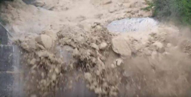
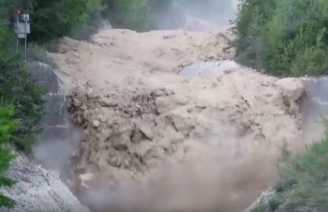
The video captures the extraordinary violence and power of such an event, with its boulder-choked front and more fluid main body:-
The terrifying Illgraben debris flow on 29th May 2017. Still from a Youtube video by Pierre Zufferey.
.
The Illgraben site includes a warning system for debris flows. It appears that this worked as planned – the video captures the flashing light of the warning system as the debris flow front moves through:-
Successful activation of the warning system for the terrifying Illgraben debris flow. Still from a Youtube video by Pierre Zufferey
.
A mudflow in Embu, Kenya
Of course landslides do not have to be this violent. The Kenya TV news report below, from 25th May 2017, features a mudflow from Kanyakiri village in Embu, Kenya that appears to have caused massive damage to a tea plantation. Note the deeply weathered red soils, similar to those from my post about Sri Lanka last week:
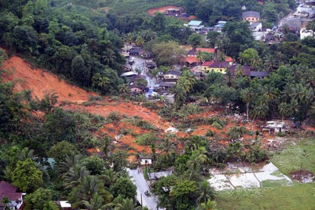
Over the last week Sri Lanka has suffered a major landslide and flood crisis, caused by heavy rainfall. This is not the first such event – indeed there have been many in the past. Local news reports suggest that 203 people have been killed, with a further 96 reported to be missing. Over 630,000 people have been affected across 15 districts of Sri Lanka. About 74,000 people have been displaced. The image below, from AP, shows one of the landslides:
AP image of one of the landslides in a residential area of Kiriella, in Ratnapura district of Sri Lanka.
.
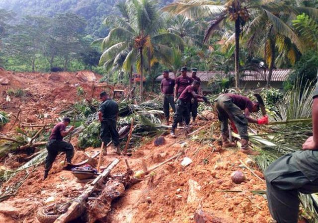
Whilst this image shows another of the landslides, at Kiribathgala, in Ratnapura district, which killed 18 people:-
AP image of the aftermath of a landslide in Kiribathgala, in Ratnapura district, Sri Lanka
.
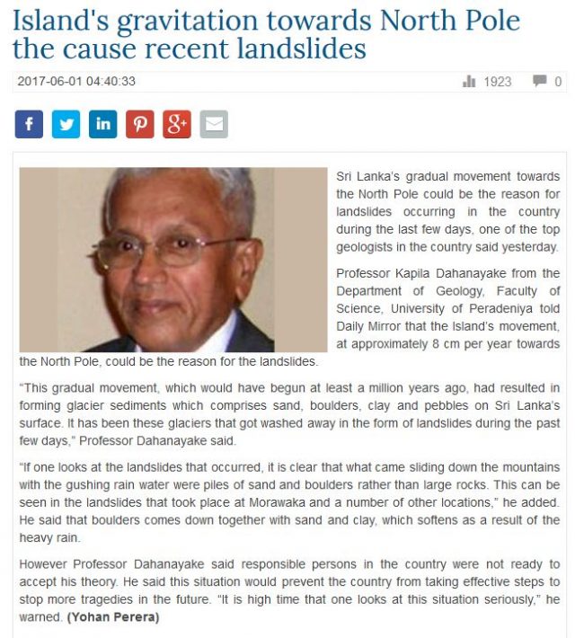
More rainfall is forecast. As is normally the case, the media are now looking for explanations for the disaster. As a result the Daily Mirror in Sri Lanka, not to be confused with the UK tabloid equivalent, has an extraordinary piece of landslide weirdness today. It is so amazing that I thought it best to provide a screenshot of the article:
Now Professor Kapila Dahanayake appears to be a highly credible scientist with an impressive CV. I am not sure if he is being misquoted in the article, but I feel I need to rebut the explanation that it provides. These landslides have nothing to do with the movement of Sri Lanka towards the North Pole, and there are no recent (i.e. Quaternary or Holocene) glacial deposits in Sri Lanka. The country is only about 700 km from the equator; geologically-recent glaciation makes no sense here.
The materials involved in these landslides can be seen in the images above. These are classic residual soils – i.e. they deeply weathered soils generated through degradation of the bedrock through chemical weathering under the tropical climate. The climate of Sri Lanka is ideal for deep chemical weathering, being both hot and wet. These soils are seen throughout the tropics; they are very often red in colour due to the presence of iron. The presence and properties of these residual soils in Sri Lanka is well-documented and is not contentious. There is nothing in the images above, or any others, to suggest that these materials are anything other than standard well-drained residual soils.
Sri Lanka has a serious landslide problem. The presence of these deep, weak soils in a climate that brings heavy rainfall events is naturally problematic. Put on top of that the loss of natural vegetation, the effects of human disturbance (slope cutting, road building and mining for example) and the impacts of potential increases in rainfall intensity due to climate change, and the likelihood for devastating landslides is clear. This understanding also points the way to appropriate levels of mitigation of course; to blame these events on a shift towards the North Pole is not helpful, in my view.
Dave Petley is the Vice-Chancellor of the University of Hull in the United Kingdom. His blog provides commentary and analysis of landslide events occurring worldwide, including the landslides themselves, latest research, and conferences and meetings.
Subscribe to the Landslide Blog
Ideas and opinions expressed on this site are those of the authors and commenters alone. They do not necessarily represent the views of the American Geophysical Union.

 Dave Petley is the Vice-Chancellor of the University of Hull in the United Kingdom. His blog provides commentary and analysis of landslide events occurring worldwide, including the landslides themselves, latest research, and conferences and meetings.
Recent Comments