
31 May 2017
Illgraben – another dramatic debris flow video
Illgraben catchment – another dramatic debris flow video
In July last year I posted a video of a very violent debris flow video from the Illgraben catchment, located near to the near the village of Susten (Leuk), in Canton Valais, Switzerland. As I noted at the time, the Illgraben catchment is particularly interesting because it generates a large number of debris flows, some of which are very large. Since 2000 WSL has been using Illgraben as a monitoring site for debris flows. They have installed instrumentation in the catchment and in the debris flow channel. Not surprisingly, cameras are a part of the set-up, meaning that several large debris flows have been recorded. WSL has also built a warning system for the catchment in order to protect the local population. The 2016 debris flow was so large that it damaged much of the scientific instrumentation.
It appears that on 29th May 2017 another enormous debris flow occurred in the Illgraben catchment. The video has been posted to Youtube by RRR Oberwallis:
.
As the image below shows, this is a flow that is characterised by a front with huge blocks:-
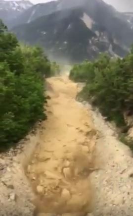
Still from a Youtube video of the 29th May 2017 debris flow at the Illgraben site in Switzerland
.
This video was also captured from a distance:
.
And the latter part of the flow from the side (this is not a recommended place to stand!):-
.
20 Minutes has an article (in French) about the event. a rough translation is as follows:-
Thousands of tons of mud ploughed its way through the Illgraben, one of the most active basins of the Swiss Alps, in the area of torrential debris. Within a few seconds, the torrential debris reached the bridge from which the reader Beat Kellenberger filmed the spectacle of nature. “A quarter of an hour before, there were already heavy noises,” explains the Swiss man, who said that these avalanches of water, fine sediments and rock are triggered once or twice a year in this region of Haut- Valais.
The early weekend torrents were caused by a combination of thunderstorms, rain and meltwater, writes the Institute for the Study of Snow and Avalanche (SLF). They added that the mass had flowed into the Rhone and that the inhabitants of the region had been warned in time. According to estimates by the SLF, a volume of about 75,000 cubic meters was discharged Monday in the Illgraben basin, the equivalent of 25 Olympic swimming pools.
30 May 2017
Northern Tajikistan: An extreme mudflow video
Northern Tajikistan: An extreme mudflow video
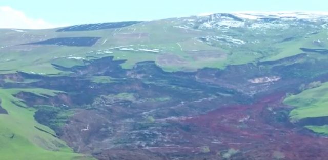
A new video appeared online yesterday showing an extreme mudflow from northern Tajikistan. This landslide, which has been posted by Radio Free Europe, apparently occurred on 28th May, triggered by snowmelt:
.
Whilst the commentary describes the location, I have not been able to translate this into a geographical location as yet. The landslide is an exceptionally large mudflow. Its interaction with the river, and the very large displacement wave that it generated (see the image below) are both unique in terms of video capture I think:
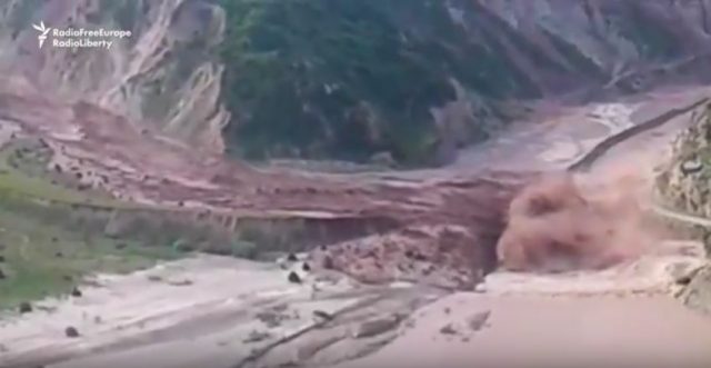
The dramatic mudslide in N. Tajikistan on 28th May 2017, via Youtube
.
18 May 2017
Landslides that make you gasp part 1: Yallourn
Landslides that make you gasp Part 1: Yallourn
I thought it would be fun to do an occasional series on landslides that make you gasp – i.e. those that cause genuine surprise – and a first good example is the Yallourn landslide. This one happened at the Yallourn Coal Mine in November 2007. I had never seen one quite like this before, and indeed since:
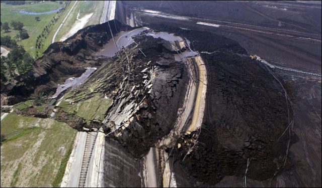
The Yallourn Coal Mine landslide in November 2007
.
This remarkable landslide is described in an article from the time in the Herald Sun:
A HUGE landslide at one of Victoria’s biggest power plants – Yallourn power station – has slashed electricity production. The landslide has left Yallourn running at less than a third of its capacity ahead of a week of forecast 30C days.
The slide appears to be a deep-seated rotational failure. An investigation after the event led to a report in the Sydney Morning Herald about the landslide:
A HUGE mine collapse that crippled a vital Latrobe Valley power station was caused by slack and lapsed safety precautions, a report has revealed. Mine consultants had lacked the skill to give competent advice for more than a decade, according to the official investigation into the spectacular Yallourn mine failure in late 2007. And the State Government-appointed investigator, Tim Sullivan, found evidence that the Latrobe Valley’s brown coal mines and the massive pumping of groundwater associated with them could be causing earth shifts outside the mines’ boundaries that posed a risk to nearby dams and roads. This finding has prompted the Government to establish a valley-wide review of the region’s stability.
And
In his report recently tabled in Parliament, Mr Sullivan said the expert consultants failed to pick up obvious signs of the mine’s imminent failure. The day before the collapse, large cracks appeared on the road on top of the wall, a pipe and line of power poles along the wall had begun to curve and large amounts of water were gushing into the mine at 500 litres a second. Despite this, the consultants concluded that “catastrophic failure was unlikely”. But Mr Sullivan, who also reported on the 1997 Thredbo landslide, said the problem went back many years to when experts approved the cancellation of two fundamental mine safety measures in the name of “efficiency”.
It is common practice in the Latrobe Valley to relieve the build-up of groundwater by drilling horizontal bores and pumping water out of deep aquifers. If this is not done, water builds in the coal seam and the wall shifts in what is called “block sliding”. But in 2002, on consultant’s advice, the mine stopped drilling horizontal bores and, in 2004, stopped taking water from the deep aquifer below the floor of the mine. Mr Sullivan found that “somehow the historic understanding and knowledge became lost or was no longer properly appreciated”.
17 May 2017
A new video of the giant Kurbu-Tash landslide in Kyrgyzstan
A new video of the giant Kurbu-Tash landslide in Kyrgyzstan
AKI Press has posted to Youtube a new video of the extremely large Kurbu-Tash landslide in Kyrgyzstan:-
.
The accompanying text states that:-
The landslide that started moving and damaging houses earlier engulfed 56 houses in total, the press service of the Ministry of Emergency Situations said. As of May 13, some 35 power poles and several social objects are among those damaged by landslide. No victims were reported. The residents of the village have been earlier relocated. Employees of the Ministry removed all valuable things from houses and objects. Now 61 houses, a school, a kindergarten, a rural health post and a mosque are under the landslide threat. The massive landslide with the volume of 2.8 million cubic meters hit Kurbu-Tash village on April 23-24 and damaged 84.8 ha of agricultural land.
A couple of things of interest in this landslide. First, as I noted in my earlier post about this landslide, it is a reactivation of a portion of a much larger relict landslide complex. This complex can be clearly seen in the part of the video below:
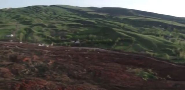
The relict landslide complex that was the source of the Kurbu-Tash landslide. Still from a Youtube video by AKI Press.
Note the hummocky terrain that is so characteristic of landslides, and the huge lateral scarp cutting across the landscape. Second, there are signs that this landslide is very actively retrogressing and enlarging. The still from the video is particularly revealing, showing multiple areas of new failure:
Areas of enlargement of the Kurbu-Tash landslide in Kyrgyzstan. Still from a Youtube video by AKI Press
It is notable that this landslide is enlarging away from the main track of the slide. Unfortunately there seems little to stop further retrogression, with devastating effects on the grassland landscape. Sadly the spate of landslides in Kyrgyzstan this year shows no sign of ceasing – this report provides details of yet another major landslide yesterday, and a very lucky escape for the occupants of a truck.
16 May 2017
The Pas de l’Ours landslide: an actively moving rockslide in the Queyras Valley of France
The Pas de l’Ours landslide: an actively moving rockslide in the Queyras Valley in France
Clément Hibert and his colleagues (see full list below) at the University of Strasbourg have kindly provided information about a landslide that they are currently monitoring in the Queyras Valley in France. This rockslide, known as the Pas de l’Ours landslide, is located about 400 m upstream of the town of Aiguilles. It is quite easy to spot on Google Earth:-
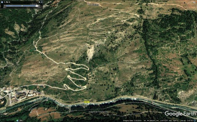
Google Earth image of the Pas de l’Ours landslide in the Queyras Valley
.
This rockslide is large – Clément has provided the annotated image below to show its scale:-
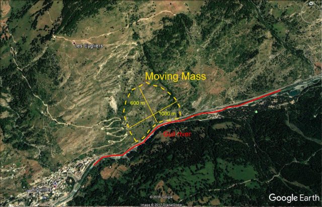
The Pas de l’Ours landslide in the Queyras Valley, image via Clément Hibert
.
Clément describes the landslide thus:
It has developed in unconsolidated schists and moraines. The total volume of the moving mass is estimated at 15 millions cubic meters, with a width of the unstable area of 1 km and a length of 600 m , which makes it one of the largest active slow-moving landslide in the Alps.
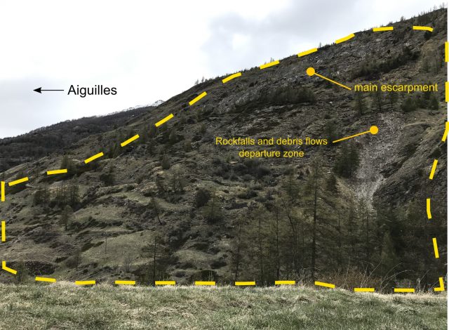
Panoramic view of the Pas de l’Ours landslide in the Queyras valley, via Clément Hibert
Since April 2017, numerous rockfalls and large deformation of the road at the foot of landslide have been observed (see image below), which led the local authorities to contact the University of Strasburg team to deploy a monitoring system. The principal threat identified is the possibility that a large part of the mass would collapse suddenly and block the Guil river in the valley below. This could create an important natural dam and totally block the access to two towns (800 inhabitants) located upstream in the Queyras valley.
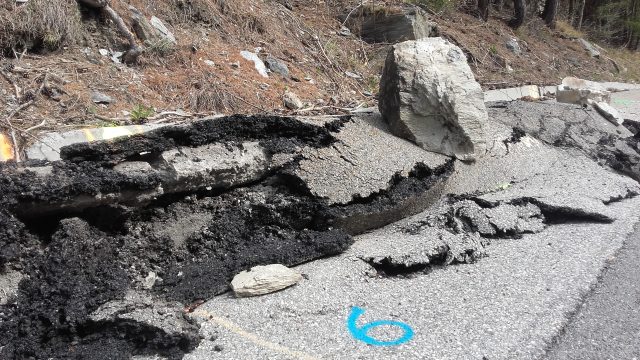
Deformation of the road at the toe of the Pas de l’Ours landslide in the Queyras Valley
.
Whilst the morphology of the landslide also suggests extensive ongoing deformation:-
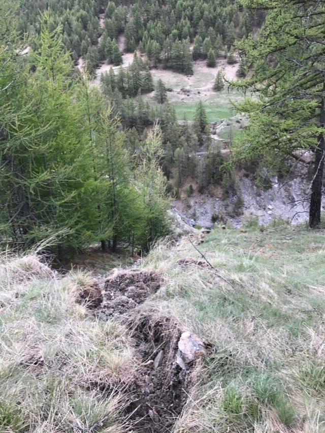
Signs of deformation in the Pas de l’Ours landslide in the Queyras Valley. Image via Clément Hibert
.
Because the landslide is moving so rapidly, the University of Strasbourg team have deployed INSAR monitoring at the site. This data suggests that parts of the landslide are moving at over 50 cm per day. The image below shows a deformation map from one of these campaigns – the movement is between 05/05/2017 and 08/05/2017:-
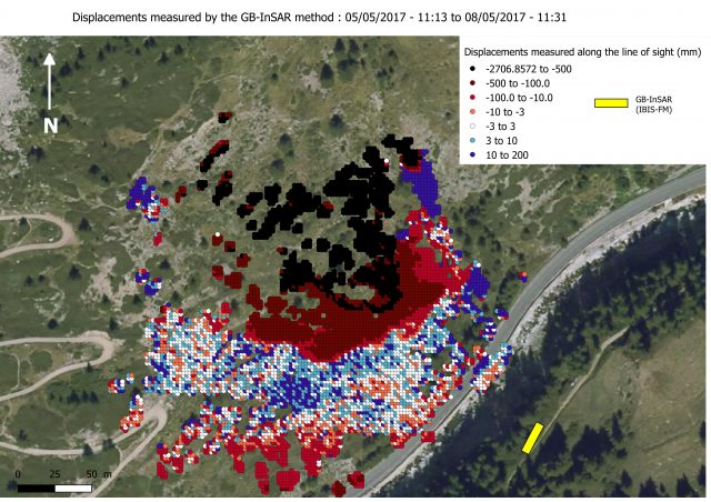
INSAR map of ground deformations at the Pas de l’Ours landslide in the Queyras Valley, via Clément Hibert
.
The team undertook further monitoring over the weekend, and have produced the deformation maps below. Note the very high movement rates now being recorded:-
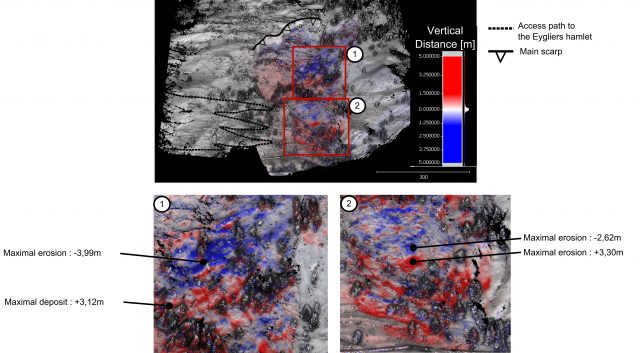
Ground based INSAR deformation map of the Pas de l’Ours landslide in the Queyras Valley between 5th and 9th May 2017, via Clément Hibert
.
The team have animated these measurements into a Youtube video. The video presents the displacement observed along the line of sight of the Ground-Based SAR. The displacements are averaged on a moving time window of two hours, and were measured during the period between 5th and 9th May 2017. It shows that the zone affected by the strongest deformation is extending toward the foot of the landslide during this period. The colours represent the displacements along the line of sight of the GB-Sar. Red indicates that the point has moved toward the instrument, blue away from the instrument, with the amplitude given by the colourscale. The yellow-ish 3D rectangle shows the position and the orientation of the instrument, so in this video we are looking at the landslide from the opposite side of the valley, slightly above the instrument. The river and the road, located at the toe of the landslide, are at the limit between the grey and the black area of the DEM.
.
It seems likely that we will hear a lot more about this landslide in the months ahead.
I must thank Clément and his colleagues at the University of Strasbourg for providing this information about a fascinating ongoing landslide problem. The team consists of:
- Jean-Philippe Malet (Team leader – University of Strasbourg / EOST),
- Clément Hibert (EOST)
- Anne Puissant (LIVE)
- Floriane Provost, (EOST)
- Grégoire Skupinski, (LIVE)
- Pierrick Bornemann (LIVE/EOST)
- Elouan Faustin (EOST)
- Gilbert Ferhat (EOST)
- Marc Fleck (University of Strasbourg / Faculty of Geography)
The monitoring system and the research carried out on site received invaluable support from the ONF-RTM (Restauration des Terrain de Montagne) service, especially from Pascal Diot and Vincent Ségel.
15 May 2017
Clinch Mountain in Hawkins County: a large rockslide in Tennessee
Clinch Mountain in Hawkins County: a large rockslide in Tennessee
This weekend a significant rockslide from Clinch Mountain closed down Highway 70 near to Cave Springs in Hawkins County in Tennessee, USA. Amanda Ketchledge, a reporter from WATE 6 News tweeted the image below of the landslide, taken by Jay Herring:

The landslide on Highway 70 N from Clinch Mountain near Cave Springs in Hawkins County. Photo by Jay Herring via Amanda Ketchledge
.
WBIR has a nice article about the landslide, which includes this aerial image of the rockslide:
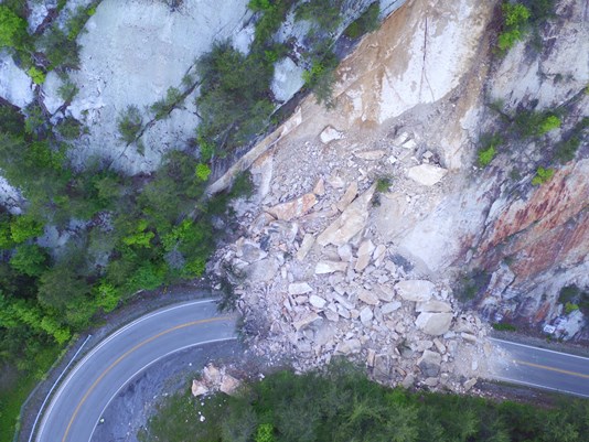
Rockslide at Clinch Mountain on Highway 70 in Hawkins County in Tennessee. Photo from the Tennessee Department of Transportation via WBIR.
.
The image below appears to be the location on Google Earth. The spot is at 36.5012, -83.0282 if you want to take a look:
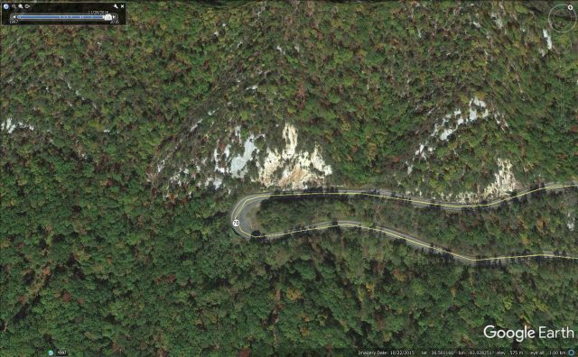
Google Earth image of the location of the landslide at Clinch Mountain in Hawkings County Tennessee at the weekend.
.
From the image above the location looks innocent enough, but the images of the aftermath suggest that this is a classic planar rockslide on pre-existing joints that dip approximately parallel to the slope. This has resulted in the generation of tabular pieces of rock debris. It is of course fortunate that no-one was on the road at this location at the time of the landslide. On Sunday work started to clear the road.
12 May 2017
The 2013 Bingham Canyon mine failure: insights into the giant Manefay landslide
The Bingham Canyon failure: insights into the giant Manefay landslide
At 9:30 pm on on 10th April 2013 a huge landslide occurred in the Bingham Canyon copper mine in Utah. I covered this event at the time, and much has been written since. The two failure events that evening had a total volume of between 65 and 70 million cubic metres, one of the largest non-volcanic landslides in North America. The failure, sometimes termed the Manefay Landslide, caused extensive damage to the mine and of course vast economic cost. An interesting aspect of the landslide was the very limited information from the operators, Kennecot Utah Copper / the Rio Tinto Group, about the event at the time. They had clearly anticipated the failure as the location of the landslide was evacuated before the slide. However, they also appeared to have underestimated its likely size and mobility as large amounts of heavy equipment in the mine were damaged.
This Google Earth image captures the scale of the Manefay landslide:
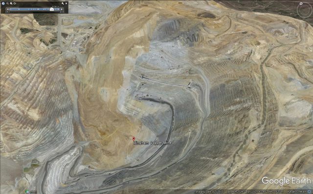
Google Earth image of the Manefay landslide at Bingham Canyon mine
I discovered yesterday that Brad Ross, who “led the team charged with developing the geotechnical studies and mine planning to demonstrate the long-term viability of the mine” has written a book, Rise to the Occasion, that “tells the dramatic story of the men and women who safely led Utah’s 107-year-old Bingham Canyon Mine through the largest mining highwall failure in history”. Brad has put a post on his website about the failure event that is extremely insightful. First, he notes that they predicted the failure two months before the collapse, allowing the evacuation. But, as he puts it:
predicting how the Manefay would fail did not go nearly as well, resulting in damaged and destroyed equipment.
and
The way that the Manefay failed was a surprise as it traveled much further and faster than anticipated. Anything in the path of the enormous mass was either destroyed or was simply picked up and shoved out of the way. This resulted in the damage and destruction of three large mining shovels (including a P&H 4100C), thirteen 320 ton haultrucks, three drills as well as a multitude of spare parts, support equipment and supplies.
Brad notes that the geotechnical team at the mine had extensive experience of failures in the pit, but that these were mostly wedge or circular failures. Their anticipation of the Manefay landslide was that it would be similar, whereas it was an active/passive block failure, that therefore behaved differently. In particular the landslide was faster and more mobile than they anticipated. Brad notes that these preconceptions might have been avoided had external experts, who might have been more open to thinking through different failure mechanisms, been involved. But he also notes that this event was so extreme that it is likely that no-one could have foreseen its behaviour.
Brad praises the operators for being willing to share their experiences in this way, and I for one welcome the insights that this event is now providing.
11 May 2017
Taiwan landslide hotspots: changing patterns through time
Taiwan landslide hotspots: changing patterns through time
Taiwan is one of the most landslide-prone countries on earth due to the combination of steep terrain, high rates of uplift, extraordinary rainfall events and regular seismicity. Fortunately, most landslides occur in the relatively sparsely populated Central Mountains, although fatalities do occur every year. Not surprisingly, Taiwan has an active high quality landslide research community and a government that is proactive in terms of slope management.
A paper just published in Landslides (Lin et al. 2017) examines an extraordinary multitemporal landslide dataset for Taiwan collected by the Forest Bureau using the Formosat-2 satellite. This may well be the most comprehensive long term landslide dataset in existence – the data includes mapped landslides across the whole of Taiwan on an annual basis from 2003 to 2012. Lin et al.(2017) have examined the changes in landslide patterns across Taiwan over this period; and the results are pretty exciting.
This is just one of the graphs from the paper. It shows the landslide ratio – the proportion of the terrain that consists of active landslides – for a number of catchments in both northern and southern Taiwan each year from 2003 to 2012:
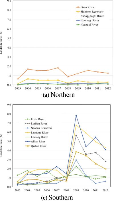
Taiwan landslide hotspots: the landslide ration through time for northern and southern Taiwan, from Lin et al. (2017).
.
Until 2008 the landslide ratio for both areas was roughly similar at around 0.5-2%. Southern Taiwan was slightly higher than northern Taiwan, perhaps, probably because the terrain in the south is more rugged. But a dramatic change occurred in southern Taiwan after 2008, with no corresponding effect in northern Taiwan. In 2009 the landslide ratio suddenly dramatically increased in the south. Thereafter the landslide ratios in southern Taiwan were much higher, although they also started to decline thereafter.
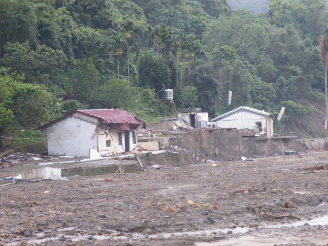
Taiwan landslide hotspots: damage from debris flows in the aftermath of typhoon Morakot
.
So what happened in 2009 in southern Taiwan? Quite simply this is the effect of the extraordinary Typhoon Morakot, which brought vast amounts of rainfall to southern Taiwan, and triggered thousands of landslides, including the dreadful Shiaolin event. The paper shows very elegantly that these extreme events leave a long term legacy of increased landsliding for years afterwards. This effect is well documented for large earthquakes in mountain chains; this paper shows very nicely that there is a similar effect for large rainstorms too.
Catastrophic rainfall events are both immediate disasters and long term crises. This latter effect is all too frequently forgotten.
Reference
Lin, S.C., Ke, M.C. & Lo, C.M. 2017. Evolution of landslide hotspots in Taiwan. Landslides. doi:10.1007/s10346-017-0816-9
10 May 2017
Geiranger Fjord in Norway: the spectacular rockslide video
Geiranger Fjord in Norway: the spectacular rockslide video
A spectacular video was posted on both LiveLeak and Youtube yesterday showing a rockslide on the flanks of the Geiranger Fjord in Norway on Monday:
.
The accompanying text states merely that:
“My school went on a Mountain trip when suddenly we heard loud noises. We SAW big blocks of rocks falling down into the Fjord and were amazed by it!”
NRK has an article (in Norwegian) that provides a little more detail, noting that the slide generated a displacement wave about 1 metre high that damaged some docks at Geiranger. The event was registered on the national seismic monitoring network across Norway, suggesting that the volume was not insignificant:
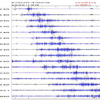
Seismic record from the Geiranger Fjord rockslide on Monday, via NRK.
.
There are a couple of interesting elements to this rockslide. The first is the timing – yet again we see a major rockslide occurring in the spring, again without an obvious trigger in terms of a seismic event or heavy rainfall. This is not unusual, and of course it may be associated with now and ice melt as temperatures rise after the winter.
Second, the video shows the mobility of a small proportion of the blocks that have detached in the Geiranger Fjord event. Take a look at this still from the video:
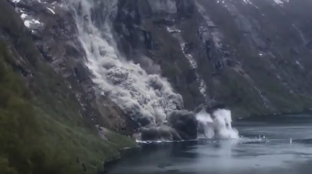
A still from the video of the spectacular rockslide at Geiranger Fjord in Norway, via Youtube
.
Note the splashes a considerably ahead of the main landslide dust cloud, which presumably mark the impact on the water of individual blocks. Only a small proportion of the blocks travel this far, but they are a nice illustration of the extreme end of the mobility distribution.
Major rockslides are of course nothing new in Norway, and not far from this site is the Akernes landslide, which is considered to be a significant hazard that is closely monitored.
9 May 2017
Landslide vs Jeep: a new video on Youtube
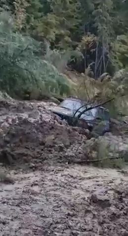
Debris slide vs Jeep: a still from a new Youtube video
.
Landslide vs Jeep: a new video on Youtube
A nice new video has appeared on Youtube showing what happens when a Jeep gets sideswiped by a rapid debris slide. (WARNING: the person behind the camera swears repeatedly as the landslide occurs):
.
The video gives no information as to where and when this happened. I suspect it will need more than T-Cut to buff that out.
 Dave Petley is the Vice-Chancellor of the University of Hull in the United Kingdom. His blog provides commentary and analysis of landslide events occurring worldwide, including the landslides themselves, latest research, and conferences and meetings.
Recent Comments