
9 July 2017
The Willow Creek landslide: a large valley-blocking slide in Wyoming
The Willow Creek landslide: a large valley-blocking slide in Wyoming
The Jackson Hole News and Guide is carrying a report about the Willow Creek landslide, a new, large, valley-blocking slide in the Wyoming Range in the USA. The slide, located in Lincoln County, appears to be substantial:
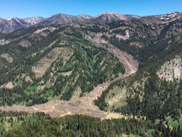
The Willow Creek landslide in Wyoming, via the Jackson Hole News and Guide.
.
The report gives some details about the landslide, and its discovery:
To [Dustin Child’s] eye the landslide was as high as 200 feet in places, covered 1/4 mile of the Willow Creek canyon and formed a 15- to 20-acre lake that’s probably 30 or 40 feet deep. As for the hazard, he didn’t think there was one.
“It could possibly could do something next spring, but there’s so much debris,” Child said. “It’s an unreal amount of debris. It dammed it up as far as it’s going to go, and now the river’s cut a stream between the debris pile and the far west side.”
It’s unclear when the yet-to-be named landslide was triggered, or if it all came down at once or slowly over the course of the spring. The remote geological phenomenon was discovered this past week, when a Bridger-Teton National Forest firefighter saw that a mountainside had given way from above.
“They were doing a flight, looking for a fire,” Bridger-Teton spokeswoman Mary Cernicek said. “They didn’t find the fire, but they found the landslide.”
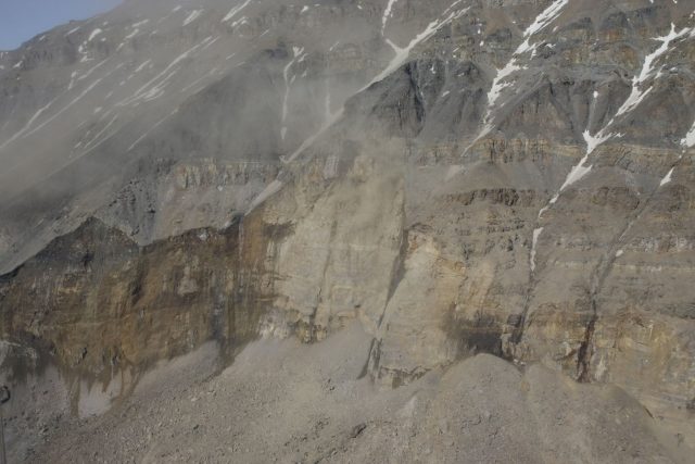
Buckrail has some additional images of the landslide, taken by Tracy Shull:-
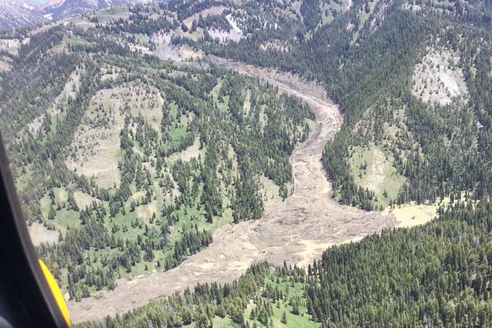
The Willow Creek landslide. Image from Tracy Shull via Buckrail.
.
The slide appears to be a mobile earth / mud flow, which has entrained a significant amount of debris from within the channel. Note the deep erosion and sidewall cutting in the upper reaches of the landslide (before the major bend in the landslide track), and then the apparent deposition, starting a short distance downslope from this point.
This is of course not an unusual event for Wyoming. Previous examples include the spectacular Bighorn Mountains landslide in 2015 and the Snake River landslide in 2011 (including the brilliant video).
7 July 2017
Mishor Rotem – another tailings dam failure, this time in Israel
Mishor Rotem – another tailings dam failure, this time in Israel
Although it has not really made the news, a major tailings dam failure occurred at Mishor Rotem in Israel on Friday 30th June 2017. Reuters has a detailed report about the event:-
Toxic wastewater that surged through a dry riverbed in southern Israel at the weekend left a wake of ecological destruction more than 20 km (12 miles) long. The flood began last Friday when the 60 meter (yard) high wall of a reservoir at a phosphate factory partially collapsed, letting loose 100,000 cubic meters (26.4 million gallons) of highly acidic wastewater in the Ashalim riverbed. That was enough fluid to fill 40 Olympic-sized pools. The toxic torrent snaked through the desert, singeing anything in its path, before collecting again hours later in a pool several kilometers from the Dead Sea, the lowest point on earth.
There are various images of the failure, of which this is the best:
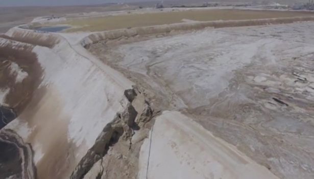
The aftermath of the Mishor Rotem tailings dam failure in Israel on 30th June, via (the very odd!) Strange Sounds
.
There is also a decent Youtube video of the failure and its consequences downstream:-
.
Haaretz has a decent article on the implications of the failure, noting that the spill has damaged an area of important ecology. The tailings pond contains the waste from a fertiliser plant, owned by Rotem Amfert.
One can only speculate about the cause of the failure, although a slip in the embankment does not seem to have occurred. Overtopping or( perhaps more probably) a piping failure seem to be the prime candidates.
I have noted previously that the failure rate in tailings facilities is unacceptably high. There would be no tolerance of this rate of failure in any other of geotechnical work, especially given the consequences of these major leaks downstream. I remain deeply frustrated that this problem is allowed to persist.
4 July 2017
La Palma – initial images of the “mega-landslide”
La Palma – initial images of the “mega-landslide”
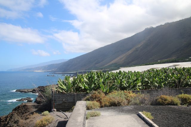
I have spent the last three days on the island of La Palma, principally to represent the University of Sheffield at the inauguration of the new GOTO telescope, yesterday. I was able to take a couple of days over the weekend to visit the site of the famous “mega-landslide” that, some people have suggested, could create a damaging Atlantic tsunami (noting of course that I am, like many others, a real skeptic of this theory). I have written about this slide – and the rather extreme interpretation that is needed to generate the sort of tsunami that has hit the headlines – previously, but this was the first time I have visited. In the post I will provide some photos of the site; I will then examine the hypothesis in more detail in a subsequent post.
The first thing to note is that La Palma is gorgeous, it has been a pleasure to visit. The geology is remarkable too. The hypothesis is that “mega-landslide” would involve a huge mass on the southern end of the island slipping to the west. This is a slide on the flank of the Cumbre Vieja volcano – which is fact an elongated volcanic ridge consisting of multiple volcanic cones, some of which date from the 1970s. This is a view along the ridge from the north:-
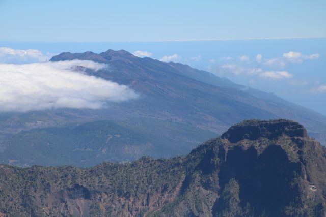
A view looking south along the Cumbre Vieja ridge (in the distance). The “mega-landslide” would involve sliding of the mass to to the west (the right on this photography)
.
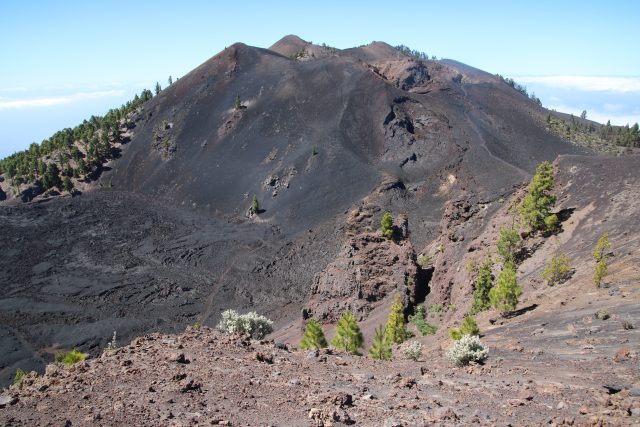
This is a view of the Cumbre Vieja ridge from the south:
The west flank of the Cumbre Vieja ridge.
.
A hike along the ridge gives a good sense of the nature of the volcanic peaks that are supposedly being pulled apart by the potential landslide:-
A volcanic peak along the Cumbre Vieja ridge.
.
Of course it would be remiss of me not to mention the telescopes that I was there to visit. This is sunset at the observatory:

Sunset at the astronomical observatory in La Palma.
.
Sometimes its not so hard to be a University Vice-President. I will post some more about the “mega-landslide” in the coming days,
28 June 2017
New landslide video: a large slip causes panic in China
New landslide video: a large slip causes panic in China
A new landslide video has appeared on Liveleak and Youtube showing a landslide causing panic in China:
https://www.youtube.com/watch?v=EpTQv0hp6A0
.
The location of the landslide is not clear – the Youtube video describes it as Sichuan-Mao Xian, but this seems to be a confusion with the deadly slide on Saturday in Xinmo. Before the person making the video starts to flee (understandably) they capture the progression of the early phases of the landslide:

A still from the youtube video showing the development of a landslide that caused panic in China
.
The Liveleak video includes some images of the aftermath:
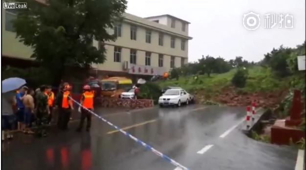
A still from a Liveleak video showing the aftermath of the landslide that caused panic in China
.
Much of China has been suffering from very heavy rainfall in the last few days. Xinhua is warning of potential floods as these rains continue:
Provinces including Guangdong, Guizhou, Hubei, Hunan and Jiangxi have seen water levels in 175 rivers rise beyond their warning levels with five rivers at record-high levels. Flooding has forced more than 170,000 people to relocate in Hunan Province. In Jiangxi Province, 235,000 hectares of crops have been destroyed with direct economic losses of 4.5 billion yuan (660 million U.S. dollars). More rainfall is forecast for southern and southwestern parts of the country in the next ten days, with precipitation in some regions likely to reach 300 millimeters within 24 hours, the National Meteorological Center said Tuesday.
A different article suggests that the heavy rainfall in the last few days has had serious impacts in Zhejiang and Guizhou:
In Zhejiang, by 7 a.m. Tuesday, 765,000 people have been affected and 149,000 had been evacuated to safer places. Around 4,800 houses were damaged, and direct economic losses have been estimated at 2.08 billion yuan (304.6 million U.S. dollars), according to the provincial civil affairs authorities.
Guizhou’s civil affairs authorities said, by 7 a.m. Tuesday, more than 1.26 million people were affected, 13 people were reported dead or missing, and 110,000 had been evacuated to safer places. A total of 56,300 hectares of agricultural crops were affected and direct economic losses reached 1.33 billion yuan.
Acknowledgement
Thanks to Pasi Jokela for highlighting this event.
27 June 2017
Gediminas Castle Hill: landslides at a historic site
Gediminas Castle Hill: landslides at a historic site
Gediminas Castle Hill is a historic mound, 40 metres high, on which the Gediminas Tower is located in the city of Vilnius in Lithuania. This is a key historic site – Gediminas Tower is the remaining part of the Upper Castle, the origins of which date to 1409. The mound is natural, being formed of exceptionally weak glacial and lake deposits that have been extensively affected by solifluction, but it has been heavily modified by humans over the centuries.

Gediminas Castle Hill, via Wikipedia
.
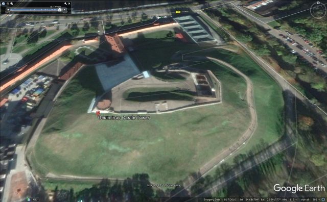
The Lithuanian news site DELFI reports today (report behind a paywall, but Sina has the content) that the Lithuanian Government is planning to declare an emergency over the landslide problems on the hill. Some of these landslides are clearly visible in the image above – note the hummocky terrain and the tension cracks. On Google Earth these images are also clearly evident. This is an image from last month showing clearly instability on the north flank:-
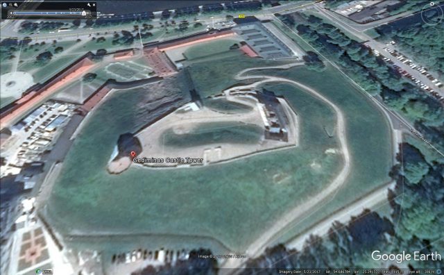
Instability on the north flank of Gediminas Castle (image via Google Earth). North is at the top of the image.
.
Whilst this image from last year shows instability on the south flank as well. Note that works were ongoing on the north flank at this time:
2016 Google Earth image showing signs of instability on the south flank of Gediminas Castle Hill
.
The emergency has been declared in order to accelerate the mitigation of the landslide problems on the hill. Works have just started to deal with the landslides on the north flank, but the south flank needs urgent attention as well.
Interestingly, this is a site with a long history of landslides. According to Milkulėnas et al. (2017) a landslide from Gediminas Castle Hill in 1396 killed 15 people, and a major failure occurred in 1551, causing damage to the castle. They also document evidence of slope mitigation works carried out between the 14th and the 17th Centuries. More recently, the hill has suffered repeated episodes of landsliding, and there have a number of attempts to stabilise parts of the hill with both soft and hard geotechnical measures.
Managing instability at such a sensitive heritage site is a huge challenge, but the indications from the images above suggest that urgent interventions are needed. Of course this is not the only heritage site threatened by landslides – I have described other examples from Serbia and India for example.
Reference
Milkulėnas V., Minkevičius V., Satkūnas J. (2017) Gediminas’s Castle Hill (in Vilnius) Case: Slopes Failure Through Historical Times Until Present. In: Mikoš M., Vilímek V., Yin Y., Sassa K. (eds) Advancing Culture of Living with Landslides. WLF 2017. Springer, Cham (parts of this paper are available here).
26 June 2017
Xinmo landslide: an update
Xinmo landslide: an update
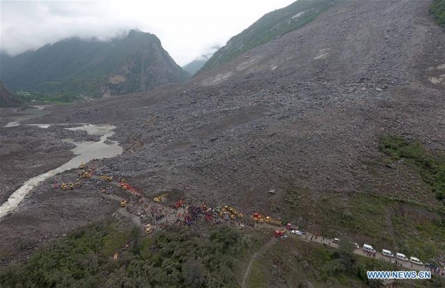
Whilst the search for survivors from the Xinmo landslide in Sichuan Province, China continues, the reality is that there can now be almost no prospect of anyone else being found alive. This image, from Xinhua, provides an indication of the scale of the problem facing the recovery teams:
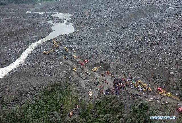
Recovery operations from the Xinmo landslide in China, showing the scale of the challenge. Image via Xinhua
.
Meanwhile, the Herald has published this image (via AP Photo/Ng Han Guan) that provides a sense of the likely mechanism of this 8 million cubic metre landslide:-
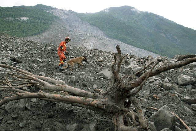
The Xinmo landslide in China, showing the slip surface. Image via Herald Net (AP / Ng Han Guan )
.
Above and behind the rescuer the slide plane is clearly visible – it appears to be an approximately planar rock surface, suggesting that this landslide was a translational slide on an existing defect. In the lower part of the hillside it has incorporated a large volume of weathered rick and colluvium.
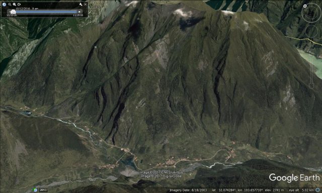
Meanwhile a kind reader has pointed out that the the history of large landslides, and of landslide dams, is described in a good Masters thesis – Song (2015) – available on the University of Waterloo website. This gives an estimated location for the 1933 Diexi earthquake, which is within a few kilometres of the Xinmo landslide, as the Google Earth image below shows:-
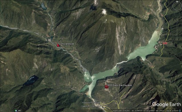
Google Earth image showing the location of the Xinmo landslide in relation to the 1933 Diexi Earthquake
.
The lakes visible on this image were formed by landslides that blocked the valley during the Diexi earthquake. As I noted yesterday, the site of the Xinmo landslide appears to be an old landslide scar, one of several on that ridge:-
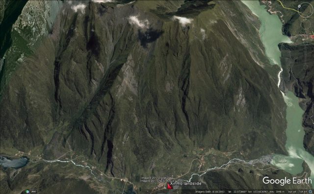
Google Earth image of the Xinmo landslide site. Note the landslide scars extending to the ridge
.
These landslide scars extend right up to the ridge crest, which is a common feature of earthquake-triggered landslides. A good hypothesis therefore might be that the Xinmo landslide was a slide in an unfailed portion of a landslide triggered in the 1933 earthquake. Interesting, Song (2015) reports that in the area around the town of Diexi:
Orientation of these rock layers [is] mainly 170°in dip direction and 30°in dip angle.
If this is true at Xinmo as well, then this would explain the defect seen in the Herald Net image above. I have no doubt that the mechanisms of this landslide will be investigated by our colleagues in China, and will be published in due course.
Reference
Song Ling (2015). Landslide damming in Western Sichuan Province, China, with special reference to the 1786 Dadu River and 1933 Diexi events. UWSpace. http://hdl.handle.net/10012/9496
25 June 2017
Xinmo: the massive landslide in Sichuan Province yesterday
Xinmo: the massive landslide in Sichuan Province yesterday
At about 5:45 am local time on Saturday 24th June 2017 a massive landslide struck the small village of Xinmo in Maoxian County, Sichuan Province in China, burying about 62 homes. On Sunday the Chinese authorities released a list of 118 people believed to be missing in addition to the 15 victims who have been recovered to date. Three people were rescued soon after the landslide, although the three year old daughter of the family is missing.
Images published by Xinhua suggest that this was a very large rockslide. The local geological survey have suggested that it was about 8 million cubic metres. The area was suffering from torrential rain at the time of the landslide, so this is being widely cited as the most likely trigger. The prospects for recovering anyone else alive look exceptionally slim:
Xinhua image of the aftermath of the landslide at Xinmo in Sichuan Province on 24th June 2017
.
The one mercy at this site is that the river does not appear to be blocked.
Wikipedia has a good article on the landslide online already, which helpfully identifies the location as 32.0663, 103.6504. Below is the Google Earth image of the site. Xinmo is the small settlement in the centre of the image at the foot of the slope:-
Google Earth image of the site of the Xinmo landslide in Sichuan Province on 25th June 2017.
.
Based upon this, the landslide yesterday is not the first failure on this slope, and indeed it may not have been the largest given the two scars that appear to extend to the ridgeline (one is under the shadow of the cloud in the image above, the other just to the right of this).
Sichuan Province is exceptionally landslide prone, and of course it was also affected by the 2008 Wenchuan earthquake and many earlier events. However, the epicentre the Wenchuan earthquake itself was about 50 km away from Xinmo, so the aftermath of shaking from this event was unlikely to have been a factor.
23 June 2017
The Kaikoura earthquake landslides: an excellent video about the mitigation works on State Highway 1
The Kaikoura earthquake landslides: an excellent video about the mitigation works on State Highway 1
The Marlborough Express has an excellent video online about the progress that is being made to mitigate the Kaikoura Earthquake landslides on State Highway 1 in New Zealand. Unfortunately WordPress no longer allows embedding of this type of video, so you will need to look at the original news item to view it.
As the accompanying article notes:
It’s six months since the North Canterbury Transport Infrastructure Recovery (NCTIR) alliance was formed and despite a few setbacks State Highway 1, between Picton and Christchurch, is expected to open by the end of the year.
…opening the SH1 transport corridor brought more challenges and a design team was brought in.
“It was a complex job so we needed to make sure we planned it right and made the SH1 and rail network reliable and safe when we did open it,” [New Zealand Transport Agency earthquake recovery manager] Steve Mutton said.
Large slips north and south of Kaikoura had to be stabilised before work to clear the landslides could begin safely. For five months helicopters with monsoon buckets laden with sea water sluiced hillsides to loosen rubble and induce rockfall before a team abseiled in to dislodge and blast away larger rocks.
“Now it’s safe to have people underneath it so we’ve been moving slip material out and creating sea walls to bring the road and rail out from some of the larger slips,” Mutton said.
The article also provides some statistics:
- 200 damaged sites, 100 damaged structures, 50 damaged retaining walls between Cheviot and Clarence
- 40 damaged sites on the Inland Rd [the alternative road inland from the coast]
- 10 major landslides north of Kaikoura, more than 30 south of Kaikoura
- 69 road bridges affected – 2 require total replacement
The plan is to open both the railway and the road by Christmas. The scale of the problem is enormous – this is just one of the many landslides that are having to be cleared for a new road and rail alignment to be constructed:
One of the Kaikoura Earthquake landslides that is being cleared. Image from Emma Dangerfield / Fairfax NZ
22 June 2017
A recent rock avalanche in the Yumthang Valley in Sikkim, northern India
A recent rock avalanche in the Yumthang Valley in Sikkim, northern India
A team of researchers from the Geological Survey of Norway (NGU; Reginald Hermanns, John Dehls and Ivanna Penna), the Norwegian Geotechnical Institute (NGI; Rajinder Bhasin), the Indian Institute of Technology Kharagpur (IIT; Sengupta Aniruddha), and the Wadia Institute of Himalayan Geology (WIHG; Vikram Gupta), have recently started a joint Indo-Norwegian project focused on the occurrence of landslides along two important road corridors connecting Sikkim (northeastern part of India) with China. They have very kindly sent some details to me of a recent rock avalanche that they have found in the Yumthang valley in Sikkim, shown below.
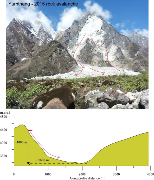
The Yumthang rock avalanche. The upper image shows a view to the headscarp and deposits of the 2015 rock avalanche in Yumthang valley. The lower image provides a cross section that shows the asymmetric profile of the valley, and the height and run-out of the 2015 rock avalanche. Note how the propagation is controlled by triangular facets on outcrops
.
They found this previously-unreported landslide during their first field visit. The rock avalanche occurred between 20/01/2015 and 12/05/2015 (based on free Google Earth Imagery). The slope failure occurred on the western slope of the valley, and travelled about 1.4 km, damming the river and creating a lake with an area of 0.2 square kilometres. The Yumthang valley has a asymmetric profile in this sector, with a western slope inclining ca. 50° while the eastern dips 32° (see the cross-section above).
Before reaching the valley floor, the failed rock mass propagated in two branches, controlled by triangular facets developed on the outcrops. The travel angle of the rock avalanche is ~32 degrees. Three overlying lobate deposits on the northern part suggest three separate events. The deposits bracket an older rock avalanche deposit of unknown age, covered by native forest.
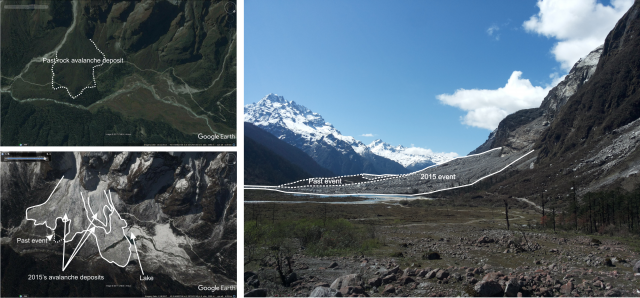
Figure 2. Past and current rock avalanche deposits in the lower section of the Yumthang valley.
.
Fallen and aligned trees on the old rock avalanche deposits and the opposite slope of the valley extend up to 300 m from the distal part of the rock avalanche, highlighting the energy of the air blast, which can be seen in the image below. However, there is an asymmetric distribution of this air blast, probably controlled by local relief.
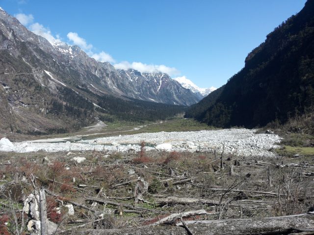
Damage to vegetation coverage caused by the air blast from the Yumthang rock avalanche
21 June 2017
Much more detail about the Greenland landslide and tsunami, including images and video
Much more detail about the Greenland landslide and tsunami, including images and video
In the last 24 hours much more detail has emerged about the Greenland landslide and tsunami, which severely damaged the settlement of Nuugaatsiaq on Saturday. The Arktisk Kommando, the Joint Arctic Command – have posted a series of images on their Facebook page that have resulted from reconnaissance missions over the site of the landslide. The best overview of the landslide site is this one:-
Overview of the Greenland landslide, via the Facebook page of Arktisk Kommando.
.
The landslide appears to consist of a large block failure of the bluff that has then run over the less steep lower slope. In the background of the image is the other section of distressed slope that is causing concern. Above the winglet another large landslide with a clearly defined rear scarp can be seen. The Arktisk Kommando have also posted this image of the landslide scar:-
The scar of the Greenland landslide, via Arktisk Kommando
.
Meanwhile, my friends at Strasburg University, Clément Hibert, André Stumpf and Jean-Philippe Malet have kindly obtained two important pieces of information that they have kindly allowed me to share. First, they have downloaded before and after images of the landslide site from the Sentinel-2 satellite:-
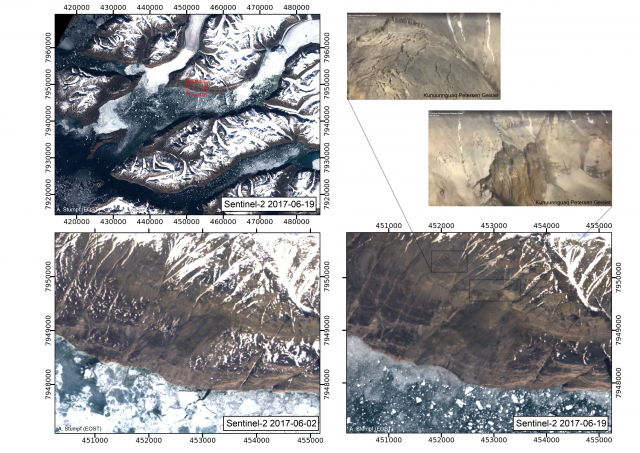
Before and after images of the Greenland landslide. Sentinel-2 data processed by Clement Hibert and colleagues from Strasbourg University.
.
Importantly, this shows that the second landslide was present in the imagery in early June, which reduces the concern of imminent failure (but does not eliminate it by any means of course). The Strasbourg team have noted that the early June image also appears to show the presence of landslide deposits in the area of the main landslide, suggesting that it might have been active before the major failure event.
Second, they have downloaded the data from the local seismic station:

Seismic data from the Greenland landslide, via processed by Clement Hibert and colleagues from Strasbourg University.
.
This data definitively answers the question as to whether the earthquake was the trigger for the landslide, or was the signal from the landslide itself. It was the latter – this signal was generated by the landslide. I am no expert on this data, so I provide the observations by Clément Hibert, who most definitely is an expert:
The high-frequency seismic signal (1-20Hz) exhibits the ‘classical’ features of high-frequency signals generated by landslides (emergent onset, no phases, lots of energy in the high-frequency >1Hz). However the onset of the long-period signal (<0.1 Hz) is peculiar. The first phase, coherent and visible at other stations, is more characteristic of shear faulting. This might suggest a very fast destabilisation of the mass. This is my assumption and I think this should be more thoroughly investigated with inversion and modeling methods for example.
Finally, more information has now emerged about the tsunami that this landslide triggered. In particular, new footage has been posted to Youtube:-
.
This tsunami struck in the middle of the night. It is simply terrifying.
 Dave Petley is the Vice-Chancellor of the University of Hull in the United Kingdom. His blog provides commentary and analysis of landslide events occurring worldwide, including the landslides themselves, latest research, and conferences and meetings.
Recent Comments