8 June 2017
The enormous Green Lake landslide in New Zealand
Posted by Dave Petley
The enormous Green Lake landslide in New Zealand
Worldwide there is a small number of landslides that a\re so large that they are almost impossible to comprehend. The Green Lake landslide in Fjordland, New Zealand, is one such example. This is a landslide that is so enormous that early mappers failed to recognise is at a slide; indeed the first proper description of the Green Lake landslide as a mass movement only occurred in 1983.
The best description of it is in a paper by Graham Hancox and Nick Perrin of GNS Science (Hancox and Perrin 2009), who note that:
- The landslide consists of the collapse of a 9 km section of the Hunter Mountains in southern New Zealand (the location is -45.78, 167.36 if you want to take a look);
- The volume of the slide is 27 cubic kilometres, making it one of the largest known landslides on earth, and the largest in New Zealand;
- The landslide covers an area of 45 square kilometres;
- The thickness of the landslide is up to 800 metres, although there is considerable uncertainty about this figure given the lack of subsurface information.
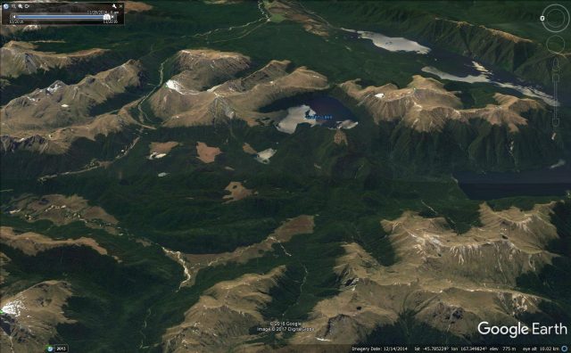
This is the Google Earth image of the landslide as it is today:-

Google Earth image of the Green Lake landslide in New Zealand
.
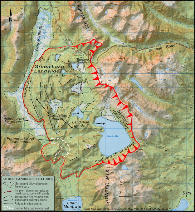
The best way to appreciate the scale of the landslide is to compare this image with the topographic map provided by Hancox and Perrin (2009):-

Topographic map of Green Lake Landslide showing its main geomorphic features. From Hancox and Perrin (2009)
.
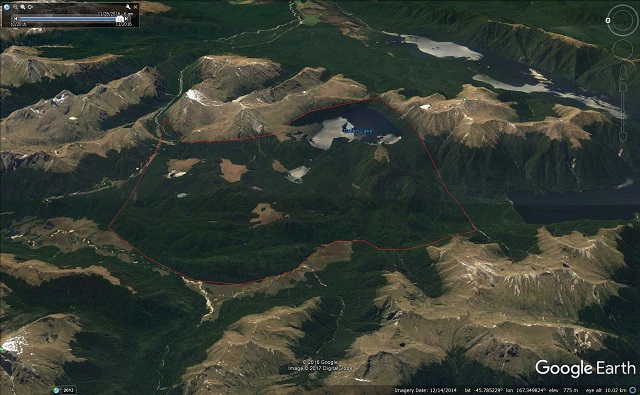
Based on this I have attempted to draw the approximate boundaries of the landslide onto the Google Earth image:-

The boundaries of the Green Lake landslide in New Zealand. Google Earth image.
.
This landslide clearly occurred after the glaciers retreated, and thus must be younger than 14,000 years old. Dating such a landslide is difficult, but Hancox and Perrin (2009) concluded that it probably happened 12,00 to 13,000 years ago. The cause of the landslide is of course hard to determine, but the glaciers had probably left the landscape in an oversteepened and thus unstable state. This part of New Zealand is subject to extremely large earthquakes. Hancox and Perrin modeled the stability of the site based on a reconstruction of the original topography, and concluded that it was very sensitive to seismic accelerations. Thus, a large earthquake is considered to have been the most likely trigger.
Reference
Hancox, G.T. and Perrin, N. 2009. Green Lake Landslide and other giant and very large postglacial landslides in Fiordland, New Zealand. Quaternary Science Reviews, 28 (11-12), 1020-1036.


 Dave Petley is the Vice-Chancellor of the University of Hull in the United Kingdom. His blog provides commentary and analysis of landslide events occurring worldwide, including the landslides themselves, latest research, and conferences and meetings.
Millions can be thankful it’s not on a coastline!
Thanks for this! I am doing some research on the impact of the Manapouri Power Scheme on the Waiau River which flows into Te Waewae Bay, transporting onto the beach the stones which I collect and polish. This landslide is near Lake Monowai which flows into the Waiau River just south of Manapouri. John https://tumblestoneblog.wordpress.com