
20 November 2018
Borba, Portugal: a major quarry landslide
Posted by Dave Petley
Borba, Portugal: a major quarry landslide
Yesterday (19th November 2018) a major landslide occurred at Borba in Evora, Portugal. This landslide is known to have killed at least two people, with a further four missing. Rescue operations are under way but are described as being exceptionally challenging. The prospects for those missing do not seem good given the nature of the landslide.
There is an excellent, detailed article in Portuguese on the Observador website, which includes the following image that gives an overview of the slide:-
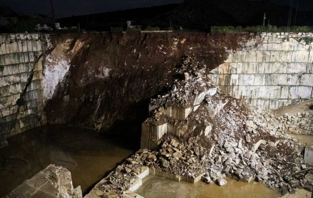
The landslide close to Borba in Portugal on 19th November 2018. Image via Observador.
.
This appears to be a complex event, with the main failure consisting of highly weathered rock and soil. Bot note the smaller slide on the right hand side of the image, consisting of both rock blocks and some weathered material. In the very right hand corner the remains of a backhoe can be seen, partially buried. This gives an indication of both the scale of the landslide and the force of the movement. The image below shows this in more detail:-
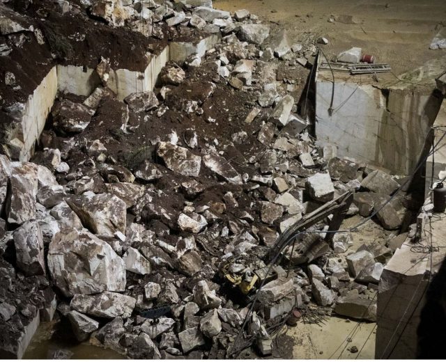
Detail of he landslide close to Borba in Portugal on 19th November 2018. Image via Observador.
.
The landslide has destroyed a road, EN255, at the top of the slope that linked Borba to Vila Vicosa. The cause of the landslide is not clear. Presumably the presence of the backhoe indicates that works were ongoing in the quarry, but there is no indication as to whether this was a factor.
The site appears to be the one shown on Google Earth below:-
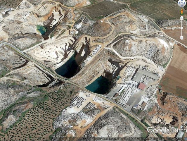
Google Earth imagery of the site of the landslide at Borba, Portugal on 19th November 2018.
.
Note the flooded old quarry sites, but also the area of more recent and apparently active quarrying on the left side.
Acknowledgement
Many thanks to Antonio Salvador for highlighting the article in Observador to me.
 Dave Petley is the Vice-Chancellor of the University of Hull in the United Kingdom. His blog provides commentary and analysis of landslide events occurring worldwide, including the landslides themselves, latest research, and conferences and meetings.
I don’t think it’s necessarily true that the failure occurred in weathered rock. Given how intact the quarry benches are, and how blocky the failure mass is, I think what we’re seeing is overburden from above the rock contact mixed in with rock during failure.
Quite telling for the failure mechanism is on the far left of the last photo. There’s a large structure in the rock mass parallel to the failure; if there were another similar structure farther into the wall it could have provided a failure plane. Adjacent to that there’s what might be a plane facing the camera; it may have been that the two planes formed a wedge.
[Yes, you may well be right in both respects. D.]
Yes Murray I think you’re probably right. I’ve seen other fly-by footage which shows other structures of a similar orientation elsewhere in the quarries. It seems to me there must also have been deeper weathered overburden or materials above the failure zone given the apparent volume which failed, compared to the weathered profiles in other walls visible which are quire shallow. Perhaps some sort of deeper weathered feature in an otherwise shallow profile. The most extraordinary element to me is that there was a public road on the very narrow aspect pillar, but that will presumably be a hot topic on the current investigation.
I have rifled through various websites in Portugal and came across the following images that I think support/confirm the above discussion:
Here are some additional images that might help to highlight the structure within the rock mass around the failure. This first link shows a view into the eastern (Borba side) corner where there is a major discontinuity doing something really weird near the surface (as is visible in your first picture):
https://bomdia.eu/duas-mortes-confirmadas-em-aluimento-em-borba/
In this link the images are quite telling; the first looks into the same corner as above and you can clearly see (I think) that the failure was on a sub-vertical joint set creating a wedge type failure mass:
https://www.cmjornal.pt/cm-ao-minuto/detalhe/sobrevivente-de-borba-olhei-para-cima-e-vi-o-carro-a-cair
And, I suspect you can possibly see the western extension of the same joint set in the quarry wall (picture looking west towards Vila Viçosa) in this picture:
https://www.radiocampanario.com/ultimas/regional/borba-operacoes-de-drenagem-de-pedreira-iniciam-as-primeiras-horas-da-manha-diz-comandante-distrital-c-som
In the centre of this last image, there is a small buttress at the base of the failed rock mass (just above the green tree in the middle of the shot) and across the face of this there seems to be an extension of the responsible joint set.
A tragedy.
ps. Thank you for your blog Dave, it is a wonderful resource