
6 September 2018
Landslides triggered by the 6th September 2018 Hokkaido earthquake
Posted by Dave Petley
Landslides triggered by the 6th September 2018 Hokkaido earthquake
There is little doubt now that the major impact of the 6th September 2018 Hokkaido earthquake is in the form of geotechnical failures. Whilst there is abundant evidence of liquefaction, it is the dramatic landslides (some reports suggest about 800 individual events) that have caught the eye and, sadly, caused most of the casualties in all probability. The USGS Shakemap data is providing some information about the distribution of ground shaking, although at this stage it is likely to be provisional. I have added to the map below the locations of the two areas of landslides that have gained most of the attention:-
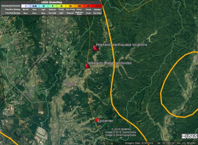
USGS Shakemap data for the 6th September 2018 Hokkaido earthquake.
.
The two areas of landslides shown above are dramatic. The ridge landslides are shown in the image below – here we seem to see failure from the ridge crest (which is typical for earthquakes) along the vast majority of the topographic feature. Sadly, at the toe of the slope were located a number of houses. The level of destruction seems to be very high; at 3 am the likelihood of escape for the occupants would have been low. Fortunately the integrity of at least some of the houses may have protected the occupants:-
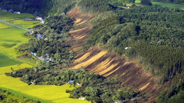
The ridge failure landslides from the 6th September 2018 Hokkaido earthquake. Image via SCMP.
.
In some cases the runout distance seems to be high. Note that the exposed slopes look to be both deeply weathered and wet, although there is not much evidence of water flowing.
The second area shown in the maps above is the zone of extremely dense landslides shown in the image below:-
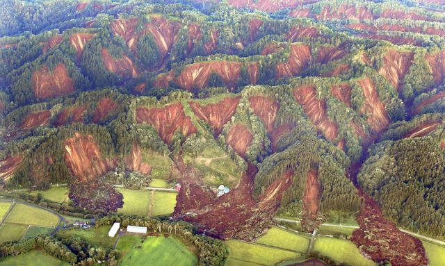
The area of intense landslides from the 6th September 2018 Hokkaido earthquake. Image via Tokyo Keizai.
.
Again note that most of the landslides, which are again in deeply weathered materials, originate from the ridge crest. The runout distances look quite long again, and in some cases they have coalesced in the drainage lines (channels) to form larger flows.
Given the earthquake magnitude (Mw=6.6 or 6.7), and depth (USGS reports 33.4 km), this level of landsliding is unusual. Indeed the USGS PAGER tool continues to indicate a low level of landslide activity. It is is likely that this high level of landslides is the result of the effects of Typhoon Jebi (Typhoon 21 in Japan), which passed over Japan in the few days before the earthquake. This might have saturated the slopes. Alternative factors may include some aspect of the shaking – perhaps the frequency was exactly right to create dramatic topographic amplification in this topography. Or perhaps the materials – these slopes may well be formed from young volcanic deposits I suspect – were particularly susceptible to seismic shaking. I wonder if there might be an element of liquefaction in some of these failures?
I am sure a great deal more detail will emerge in the days ahead. Comments and observations are very welcome.
 Dave Petley is the Vice-Chancellor of the University of Hull in the United Kingdom. His blog provides commentary and analysis of landslide events occurring worldwide, including the landslides themselves, latest research, and conferences and meetings.
The second image could be used to create a challenging jigsaw puzzle. Perhaps to be used as a sort of prayer for those affected.
Dear Dave Petley,
Thanks for your posts on Okkaido earthquake. I do agree with you that given the earthquake magnitude, this level of landsliding is unusual. Moreover I would like to call your attention on the mobilized material: as you said it appears wet, weathered and I would add that it seems the soil layer above the bedrock (which may be volcanic?). Although the run out is not so big, the shape of the accumulation bodies in the first pic, and the channelized flows in the second one, suggest to me the presence of water in the landslide deposits. Please note that in first pic the gradient of the sliding surface is not even so high (as in the second pic). After an earthquake, in Italy, we are used to observe failures affecting rocky slopes (such as rock falls, rock avalanches, reactivation of deep seated deformations) rather than soft rocks. For all these reasons I am convincing myself that some other factors related to water (such as liquefaction and/or especially eventual previous heavy rainfall) had to have a played a fundamental role in inducing these instabilities.
Asahi Shimbun (2018/09/8) quoting results of survey of experts from Hokkaido Unversty and others reports: 2-3m thick surface soil/sediment layer made up of accumulation of eruption-borne volcanic ash with pumice, wet due to typhoon-rain at the time of shaking, seems to have collapsed suddenly due to shaking and flowed together with trees downwards with a speed of more than 10m per second. Volcanic ash lacks in cohesion such that it suffers rapid disintegration upon shaking. The situation seems to resemble to the case of failure of volcanic ash deposit of Mt. Aso durng the Kumamoto Earthquake.
Instant paper on earthquake triggered landslides. I found an interesting thin there, the landslide pattern is almost the same.
Thank you Dave, thank you very much.
Amazing pictures of induced landslides, thank you to those that took them. Water clearly plays a major role in the ridgeline failure. Another possible contributing factor may be previously mobilized material from pre-existing earthquake-induced landslides. Several large earthquakes have hit the region since the 1950’s. Add the one-two punch of moisture from Typhoon Jebi, and the 6.6 m earthquake whilst still saturated. And voila!
The images and flow patterns remind me of La Conchita, CA (1995 & 2005), another example of pre-existing landslides being re-mobilized. An aerial photo recon before this failure could possibly indicate this or other potential causes.
These drone images may be of interest
https://www.facebook.com/yasu6888/videos/2021327191260766/