16 November 2018
Images and video of the aftermath of the Jinsha River landslide
Posted by Dave Petley
Images and video of the aftermath of the Jinsha River landslide
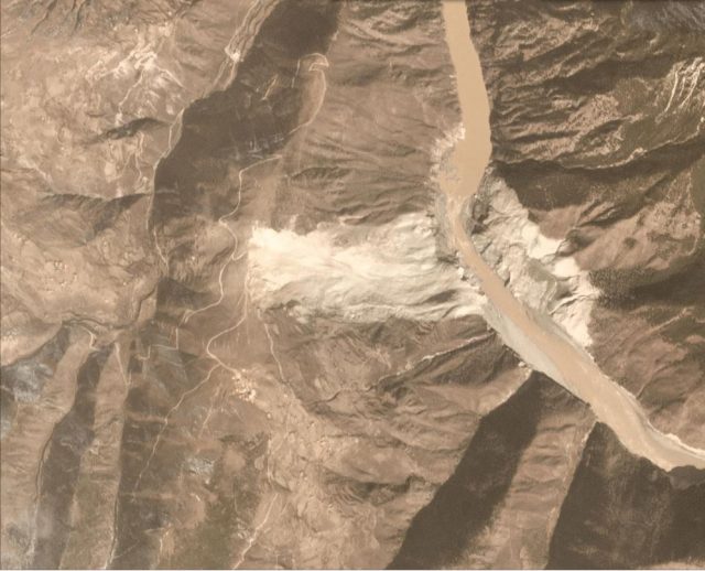
The breach event of the Jinsha River landslide in Jomda County, Tibet is now complete. The Planet Labs image below, collected on 15th November, shows the aftermath of the breaching (compare this with the image of the site when the dam was still intact):-

Planet Labs image of the Jinsha River landslide. PlanetScope orthotile, collected 15th November 2018, used with permission.
.
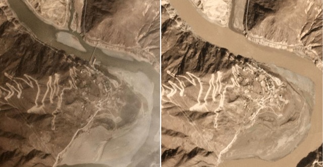
The image shows that most of the impounded water has been released and that there has been significant erosion of the landslide deposit in the process. The effects of the flood are clear downstream – this is the site of a major crossing of the Jinsha River – the image on the left is from before the flood, the one on the right is after:-

Before and after images of an area affected by the breach of the Jinsha River landslide. Planet Labs images, collected on 11th and 15th November respectively, used with permission.
.
The bridge that is clearly visible on 11th November has been swept away. The Free Tibet website has some detailed coverage of the effects of the breach of the Jinsha River landslide, including some remarkable video coverage of the breach event. This should be visible below, but as WordPress embeds files so poorly you may need to view it here.
.
This video appears to show the water flowing through the channel carved through the landslide, and collapses of the landslide deposit as the walls of the channel collapse. The Free Tibet site also has video of the effects of the downstream flooding, including collapsing buildings:
.
.
Free Tibet reports that the downstream damage is severe:-
The unceasing flooding has swept away whole villages and townships and destroyed crucial infrastructure networks including roads, bridges and schools. Townships of Drichu ka (Payul County), Ganzi (Tibetan Autonomous Prefecture), Polo (Jomda County) and Chamdo city (TAR) have been particularly affected.
The 900 year old Polo Monastery, which is “the most important and old Buddhist temple in the region” (according to Tibetan writer Tsering Woeser on social media), has been completely submerged by water. Its sacred religious artefacts have been ruined beyond repair, with monks and local Tibetans evacuated into the mountains.
Reference
Planet Team (2018). Planet Application Program Interface: In Space for Life on Earth. San Francisco, CA. Planet.com


 Dave Petley is the Vice-Chancellor of the University of Hull in the United Kingdom. His blog provides commentary and analysis of landslide events occurring worldwide, including the landslides themselves, latest research, and conferences and meetings.
Looks like this one got away from them and eroded headward.
Your prior post showed what appeared to be a sizable channel underway on the upstream side.
maybe this was shot there: Scattered oil drums appear in the foreground in the video at around 0:20 and 1:50.
The bridge being washed away on the above video is in Thangteng (Tuoding) Township, Dechen County, Dechen Tibetan Aut. Prefecture, Yunnan (迪庆藏族自治州德钦县拖顶乡), more than 450 km downstream from the barrier lake.
27°46’06.8″N 99°25’47.5″E
The other township’s bridge, located some 240 meters away, has also been washed away:
https://bit.ly/2KyVGoj