
21 December 2018
The ancient Xuelongnang landslide in Tibet
Posted by Dave Petley
The ancient Xuelongnang landslide in Tibet
In a recent paper in the journal Landslides, Chen et al. (2018) describe an ancient landslide at Xuelongnang in Tibet. This rockslide blocked the Jinsha River, creating a lake. The dating suggests that this partially breached soon after the formation of the dam, but water continued to be impounded for several hundreds of years before breaching once more. The landslide can still be clearly seen on Google Earth imagery – I have annotated the key aspects below:-
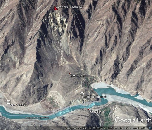
Google Earth imagery of the Xuelongnang landslide on the Jinsha River in Tibet.
.
The landslide symbol is at the crown of the very large and impressive landslide scar – according to Google Earth this is at an elevation of about 3,200 metres, whilst the valley floor is at about 2,420 metres, giving a vertical extent of over 750 metres. The remains of the landslide deposit are still clearly evident too, as is the channel formed during the breach events. Upstream, the broad plain of the lake deposit, formed when water was impounded behind the dam, is very clearly evident. The paper includes the following image which gives a better sense of the extent of the landslide:
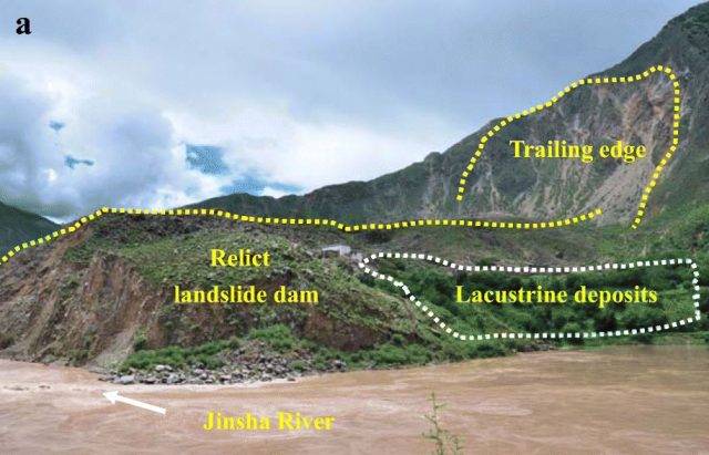
Annotated photograph of the Xuelongnang landslide on the Jinsha River in Tibet. Image from Chen et al. (2018).
Chen et al. (2018) have undertaken a very meticulous dating exercise on the landslide and lake deposits, providing insight into this multiple breaching process. They speculate that the trigger for the formation of the Xuelongnang landslide may have been a large earthquake about 2,100 years BP. This area is known to be tectonically-active, with known faults near to the landslide site and an instrumental record of earthquake events in the vicinity. Furthermore, a number of other large rockslides have been identified in close proximity to the Xuelongnang landslide. The authors found some evidence of another palaeolake deposit downstream of the landslide site, compatible with the valley suffering multiple landslide dam events. As such, there may be a similarity with the high density of large coseismic landslides in Papua New Guinea earlier this year.
Reference
Chen, J., Zhou, W., Cui, Z. et al. 2018. Formation process of a large paleolandslide-dammed lake at Xuelongnang in the upper Jinsha River, SE Tibetan Plateau: constraints from OSL and 14C dating. Landslides 15: 2399. https://doi.org/10.1007/s10346-018-1056-3
 Dave Petley is the Vice-Chancellor of the University of Hull in the United Kingdom. His blog provides commentary and analysis of landslide events occurring worldwide, including the landslides themselves, latest research, and conferences and meetings.