
30 April 2019
Bashkara Glacier: a major rock avalanche in the Caucasus last week
Bashkara Glacier: a major rock avalanche in the Caucasus last week
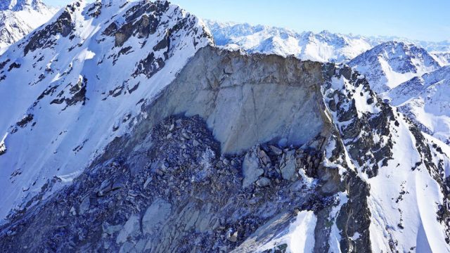
Three days ago, Михаил Докукин, a geohazard researcher on the Caucasus mountains at the High Mountain Geophysical Institute in Nalchik, Russia tweeted an image from the Bashkara Glacier in Russia. The Bashkara Glacier is suffering significant retreat, at rates of up to 8 m per year according to my fellow AGU Blogger, Mauri Pelto. This is ascribed in large part to higher summer temperatures. The tweet by Михаил Докукин uses ESA Sentinel imagery to show the deposit from a large rock avalanche in the upper reaches of the Bashkara Glacier. The location is 43.188, 42.741 if you want to take a look. This is the Sentinel image:-
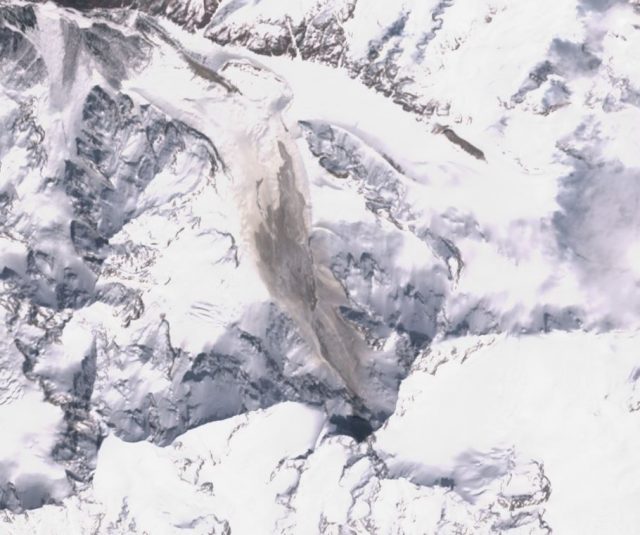
Sentinel imagery showing the major rock avalanche on the Bashkara Glacier. Image collected by ESA Sentinel on 25th April 2019, obtained via Sentinel Hub.
.
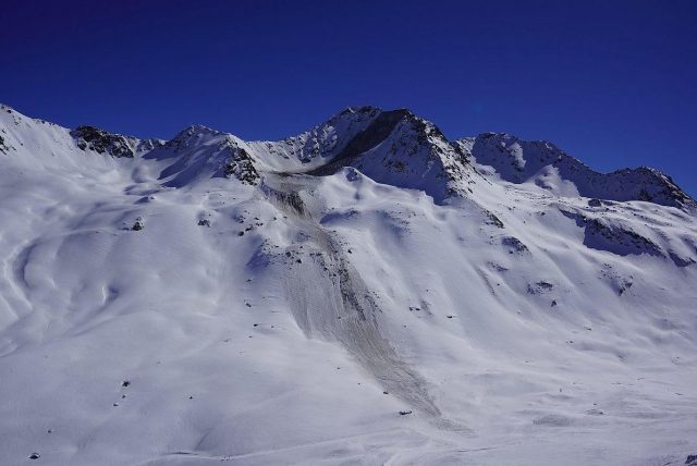
This landslide deposit is not visible on the image from two days previously:-
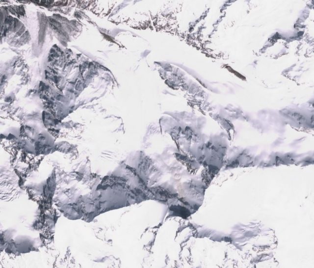
Sentinel imagery showing the site of the major rock avalanche on the Bashkara Glacier. Image collected by ESA Sentinel on 23rd April 2019, obtained via Sentinel Hub..
.
At this point there is no further information as to the timing of the landslide, although it should have registered a signal on the local seismic network. The landslide appears to be about 2.7 km from source to toe, and to have generated a deposit that is about 550 metres wide at its maximum. The source appears to be the collapse of the steep rock wall at the head of the glacier, and there is just a hint of some debris and dust in this area in the image of 23rd April, suggesting that the collapse may have had some precursory activity. In terms of mechanism, this landslide appears to be similar to the 2013 Mount Haast collapse, which was captured on the famous video. The Mount Haast event had a runout distance of 2.9 km, so broadly similar to this event. The deposit volume for that event was 2 million m³.
The Bashkara Glacier event has generated a significant amount of dust in addition to the main landslide deposit, which also suggests a rock avalanche. Unfortunately of course the deposit will be rapidly covered by new snowfall, rendering the landslide difficult to study in detail.
29 April 2019
Landslides from the 22 April 2019 M=6.1 earthquake at Gutad, Luzon in the Philippines
Landslides from the 22 April 2019 M=6.1 earthquake at Gutad, Luzon in the Philippines
On 22 April 2019 a M=6.1 earthquake occurred at Gutad in Luzon, Philippines. This earthquake occurred at a shallow depth under hilly terrain, such that landslides were likely. Sotiris Valkaniotis of Aristotle University of Thessaloniki tweeted satellite images in the aftermath of the earthquake showing coseismic landslides in a 15 x 10 km zone in the vicinity of Mount Cuadrado. Planet Labs have captured an image, taken on 25 April 2019, which shows the landslides triggered by the earthquake:-
Planet Labs image, dated 25 April 2019, showing the landslide affected area in the aftermath of the 22 April 2019 earthquake near to Gutad in Luzon, Philippines. Planet Labs Planetscope image, dated 25 April 2019, used with permission.
.
By way of comparison, this is the same area in a Planet Labs image collected on 27 February 2019, prior to the earthquake at Gutad:-
Planet Labs image, dated 25 April 2019, showing the landslide affected area prior to the 22 April 2019 earthquake near to Gutad in Luzon, Philippines. Planet Labs Planetscope image, dated 27 February 2019, used with permission.
.
It is clear that the earthquake triggered large numbers of landslides in this area, located to the northwest of the epicentre. According to the NDRRMC in the Philippines, the earthquake killed 18 people and left a further 3 missing. According to news reports, at least one fatality was the result of a landslide:-
“The rest of the fatalities came from Zambales, where a six-year-old child was crushed to death in a landslide in a mountain village of San Marcelino town.
[NDRRMC executive director and Office of Civil Defense (OCD) administrator Ricardo Jalad] said around 120 families have evacuated to safer grounds following the landslide at Mt. Bimmukel in San Marcelino.
The displaced residents came from the landslide-stricken Sitio Lomibao, Sitio Bayaron Tikes, all in Barangay Buhawen, where six-year old Waring Sernao, died from massive head injuries.”
Reference
Planet Team (2019). Planet Application Program Interface: In Space for Life on Earth. San Francisco, CA.
25 April 2019
Balakh village: yet another catastrophic jade mine landslide in Myanmar
Balakh village: yet another catastrophic jade mine landslide in Myanmar
Early on Tuesday morning a slope collapsed at a jade mine at Balakh village in Myanmar. Whilst there is some uncertainty about the number of miners trapped in the debris, the most likely toll appears to be 54 people. Reports from within Myanmar suggest that this collapse occurred in a company operated facility, rather than involving unregulated mining or scavenging on waste piles. The reports seem to indicate that the slope collapsed onto residential accommodation for the miners.
There are some images of the landslide online – these two are interesting:-
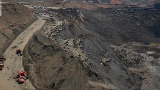
The aftermath of the landslide at Balakh Village in Myanmar on 23rd April 2019. Image from STRINGER/AFP/Getty Images via Pressfrom.info.
.
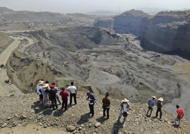
The aftermath of the landslide at Balakh Village in Myanmar on 23rd April 2019. Image from Zaw Moe Htat via AP and Pressfrom.info.
.
The first image shows the source area of the landslide. It clearly shows a series of very large rotational failures, including one with very substantial movement. The second images shows the run out zone . It is clear that the landslide has undergone a form of liquefaction to form a highly mobile mass. This explains the description of the landslide as a “mud lake”. Some reports suggest that this was a tailings pond collapse, but judging by the images it seems reasonably likely that this is a misinterpretation of the liquefaction process. Whatever the cause, the consequences are that there are no prospects of survivors from the disaster beyond the three injured people already rescued.
I have written repeatedly about the terrible toll of mining induced landslides in the Hpakant area of Myanmar, which have taken almost one thousand lives to date. The government repeatedly assures the international community that they will improve regulation, but this is an industry that is mired in corruption, with frequent allegations that the profits are funneled into the bank accounts of the military leaders in Myanmar. It seems inevitable that I will be posting about events in the Hpakant area well into the future.
20 April 2019
Taroko Gorge: a dashcam video of a very near-miss with a co-seismic rockfall in Taiwan
Taroko Gorge: a dashcam video of a very near-miss with a co-seismic rockfall in Taiwan
A magnitude 6.1 earthquake struck eastern Taiwan on Thursday 18th April 2019 at at 13:01 local time. This shallow earthquake shook the extraordinarily beautiful Taroko Gorge in eastern Taiwan, a major tourist attraction with very tall, very steep slopes above a major highway. A dashcam video has been posted to Youtube, shot by a motorist on the road at the time of the earthquake. Unsurprisingly, the earthquake triggered large numbers of rockfalls. The dashcam video captures a near-miss event that was extraordinarily close to being a tragedy:-
.
The video hits the road just in front of the car, and then fragments and bounces, with the debris flying over the top of the vehicle. Note that further rockfalls also occur:-
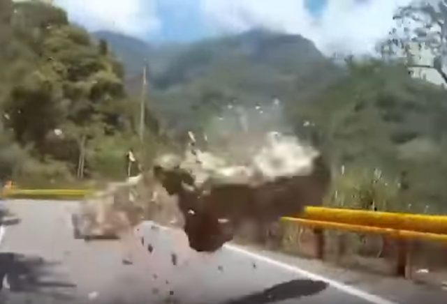
A near-miss with a boulder in Taroko Gorge, Taiwan. A still from a Youtube video posted by Taiwan News.
.
Taiwan News has some detail about this event:-
“In the video, a couple is casually driving on a sunny day through the Luoshao Road Section of Provincial Highway 8 in Taroko National Park. When the car reaches approximately the 153 to 161-kilometer mark, the driver feels the road start to shake, and in a twist of fate, he decides to pull over briefly, possibly buying precious seconds that saved his life.”
The video has a date and time stamp in the footer that suggest that it is genuine.
Elsewhere, two hikers were struck by falling rocks in Taroko Gorge. One of these individuals, a Malaysian national, suffered serious injuries. There is also a nice video of an earthquake-triggered rockfall elsewhere in eastern Taiwan, in this case at Qingshui Cliffs:-
.
It is likely that similar events have occurred on the steep slopes in Hualien County, but I have seen no reports of large landslides to date.
18 April 2019
A dramatic debris flow video
A dramatic debris flow video
This video has been posted to Youtube, but with no explanation:-
.
It shows a debris flow cascading over a cliff above a mountain road, with a trapped 4×4. It appears that the part of the event captured by the video probably follows the initial major surge, which appears to have deposited a large volume on the road:-
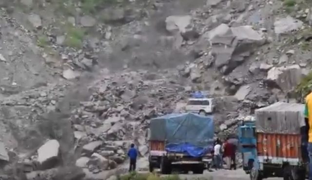
A debris flow on a road, probably in South Asia. Still from a video posted to Youtube.
.
Does anyone know anything more?
Parts of the Himalayas are suffering from unusual levels of pre-monsoon rainfall, with substantial losses from landslides and floods. For example, the Jammu-Srinigar highway has been blocked repeatedly over the last few weeks, and there have been several fatal landslides in Pakistan this year already. In the case of Pakistan, this rainfall has been sufficiently unusual to justify a dedicated Wikipedia page. An editorial in Pakistan Today questions why hazards driven by climate change are not given a higher priority in that country:-
“The weather predictions by the Pakistan Meteorological Department and the warnings to the population by the Pakistan Disaster Management Authority provide insufficient time to the population to fend for itself. The concerned agencies, that include police, Rescue 1122 and provincial disaster management authorities, are under-staffed, ill-equipped, and mostly urban-specific. The way climate change is hitting Pakistan, any extreme climate event can lead to a disaster. There is a need to strengthen the forecast and rescue bodies now rather than wring hands and blame the past governments when the tragedy occurs.”
To date, 2019 has seen an unusual level of landsliding worldwide, with fatalities totaling over 1,000 already, even though the first three months of the year are usually the least active period. Significant losses have occurred in rainfall induced events in Africa, South America, SE. Asia and in East Asia, as well as in mining and construction induced landslides.
16 April 2019
Planet Labs Skysat image of the Hindalco tailings failure
Planet Labs Skysat image of the Hindalco tailings failure
Planet Labs have successfully acquired a high resolution SkySat image of the Hindalco Tailings failure in Muri, India, which occurred last week. It is interesting to compare this with the pre-failure imagery. This is a Google Earth image of the site, collected on 4th April 2018 – i.e. almost exactly one year before the collapse:-
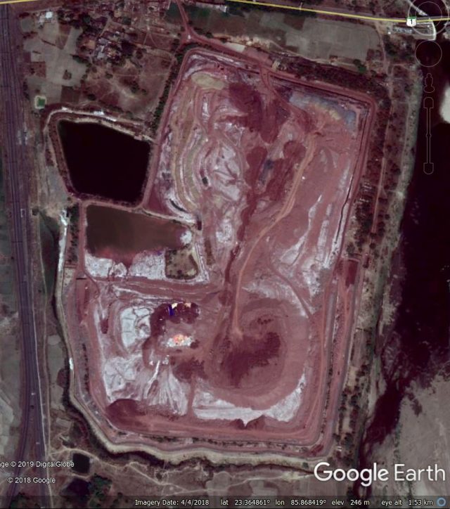
Google Earth image of the site of the Hindalco tailings failure. Image collected on 4th April 2018.
.
In comparison, this is the Planet Labs Skysat image of the site after the collapse:-
Planet Labs Skysat image of the site of the Hindalco tailings failure. Planet Labs Skysat image collected 15th April 2019, used with permission.
.
Whilst this is a more detailed view of the area that failed:-
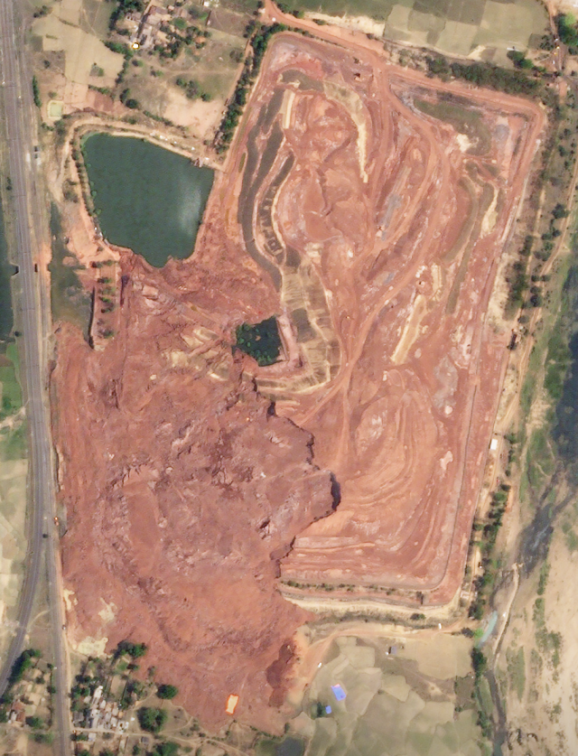
Planet Labs Skysat image of the site of the Hindalco tailings failure. Planet Labs Skysat image collected 15th April 2019, used with permission.
.
The failure appears to have occurred in the retaining structure on the west side, allowing tailings to move to the west and to a lesser degree to the south. Note the large rear scarp of the landslide. In this case the mobility of the tailings has been quite limited, presumably because they are comparatively dry?
A key task will now be to contain the waste prior to the monsoon to prevent larger-scale contamination of the area. At the moment the affected area is quite limited.
Meanwhile, the Jharkhand State Pollution Control Board has cancelled the consent to operate of the works at Hindalco. Interestingly, there also reports that the retaining wall was designed by IIT Mumbai and IIT Roorkee, who are now under investigation. A panel has been convened to understand the causes of the failure.
Reference and acknowledgement
Planet Team (2019). Planet Application Program Interface: In Space for Life on Earth. San Francisco, CA.
Thanks to Robert Simmon for help in acquiring the Skysat image.
15 April 2019
Flüela Wisshorn: a large rockslide in the Alps on 18th March 2019
Flüela Wisshorn: a large rockslide in the Alps on 18th March 2019
On 18th March 2019, late in the night, a large rockslide occurred at Flüela Wisshorn in the Swiss Alps. The best image of the landslide can be found in a good, detailed article about the event on the Tages Anzeiger website (the article is in German, but Google Translate does a good job):-
The large rockslide at Flüela Wisshorn on 19th March 2019. Image by Robert Kenner, SLF, via Tages Anzeiger.
.
This rockslide has been investigated by the WSL Institute for Snow and Avalanche Research (SLF), and some of their initial findings are described in the article in Tages Anzeiger. The Flüela Wisshorn rockslide occurred shortly after midnight, meaning that there were no people at risk, with a volume of about 250,000 cubic metres. Images from the site suggest a failure on an existing defect in the rock mass; interestingly the rockslide scar extends to the ridge:-
The source area of the large rockslide at Flüela Wisshorn on 19th March 2019. Image by Robert Kenner, SLF, via Suedostschweiz.
.
Whilst most of the debris has had a comparatively limited runout (and it is interesting to see how much material remains on the steeper parts of the slope), a portion of the landslide has traveled a significant distance. This image, via Deutscher Alpenverein, is a rather beautiful illustration of that:-
The full runout of the large rockslide at Flüela Wisshorn on 19th March 2019. Image by Robert Kenner, SLF, via Alpenverein.
.
The article in Deutscher Alpenverein notes that lowest part of the track seems to have the characteristics of a snow avalanche (with some debris content), rather than a rockslide. The timing of the rockslide is quite interesting, occurring in the latter part of winter and at night. I have no doubt that SLF will investigate this event further, and will be interested to read their conclusions on triggering in due course.
Acknowledgement
Thanks to Axel Volkwein for highlighting this event.
13 April 2019
Hindalco, Muri: another tailings failure, this time in India
Hindalco, Muri: another tailings failure, this time in India
On 9th April 2019 yet another significant tailings failure occurred, this time at the Hindalco works at Muri in Jharkhand, India. The location is 23.364, 85.871.
There are some limited reports of this failure event in the media. For example, the Daily Pioneer has a reasonably detailed report:-
“On Tuesday afternoon, boundary wall of the caustic pond created by Hindalco Ltd to dispose of red mud recovered in the process of extracting aluminum collapsed thus leading to a landslide like situation in Muri near the railway tracks.
“As an impact of the boundary breach, a few dumpers, earth movers and tractors which were parked in the area were buried in the mudslide.”
There are very few images of this event in the media. The best idea of what happened can be gained from a Youtube video posted by R M Kumar:-
.
This includes the following still:-
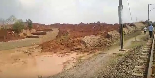
The Hindalco tailings failure at Muri in India. Still from a Youtube video by R M Kumar.
.
Meanwhile Bhaskar.com has this image:-
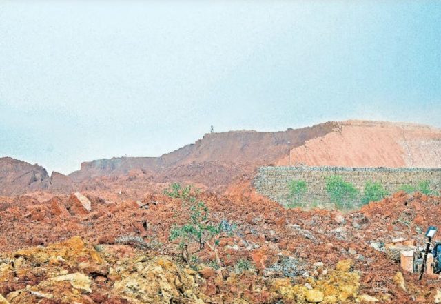
The aftermath of the Hindalco tailings failure at Muri in India. Image from Bhaskar.com.
.
Both images appear to show significant failures through gabian walls. To me, to support a tailings pile on this scale with gabian structures is something of a surprise. An inquiry has been ordered; it will be interesting to see what it shows.
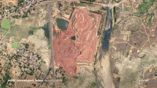
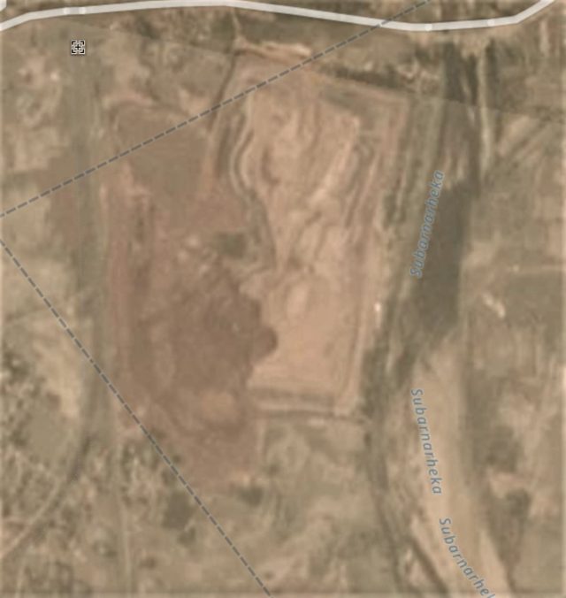
Planet Labs have captured the aftermath of the tailings failure via their Planetscope satellites. This is an image of the area before the failure:
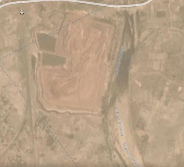
The site of the Hindalco tailings failure at Muri in India. Planet Labs Planetscope image collected 6th April 2019, used with permission.
.
Whilst this is the aftermath:-
The aftermath of the Hindalco tailings failure at Muri in India. Planet Labs Planetscope image collected 10th April 2019, used with permission.
.
The images suggest that this is a significant failure. Astonishingly, it is not clear as to whether there has been loss of life. Some reports suggest up to 20 people may have been killed, but most reports suggest a rather lower human impact. Meanwhile, operations at the plant have been suspended.
Reference and acknowledgement
Planet Team (2019). Planet Application Program Interface: In Space for Life on Earth. San Francisco, CA. https://www.planet.com
Thanks to a friend in India who highlighted this event to me.
10 April 2019
GEER report on the Palu landslides
GEER report on the Palu-Donggala landslides
The GEER team that travelled to examine the Palu-Donggala landslides, triggered by the 28 September 2018 Mw=7.5 Palu earthquake in Indonesia, have now published and made available their report (Mason et al. 2019). This is, as far as I am aware, one of the first detailed published reviews of these intriguing but terrible flowslides.
The report is detailed and well-curated, providing insight through both field observation and eye-witness reports. There is far too much to cover in a single post, so I will highlight what I consider to be the key take-home messages:
1. The report confirms that there were four major flowslides triggered by the earthquake (the team also surveyed a smaller landslide in the same area), inflicting huge losses on the communities in the local area. These are shown in the image, from Mason et al. (2019), below:
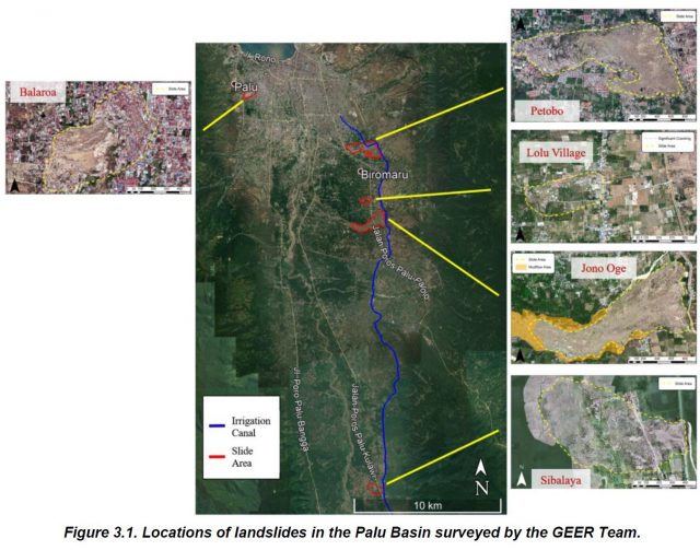
Locations of Palu-Donggala landslides surveyed by the GEER Team (Source: Mason et al. 2019).
2. The team estimate that 80% of the 4340 fatalities caused by the earthquake were the result of these four flowslides, confirming that this is the worst landslide disaster in the last five years.
3. The team note that the landslides occurred on very low angled slopes. Typically these were in the range of 2 to 4% grade.
4. Field observations confirm that these landslides were the result of extensive liquefaction, triggered by the earthquake shaking. The team observed sand boils at the landslide sites, and in the surrounding areas, which is a diagnostic feature of liquefaction processes.
5. But interestingly, and importantly, the team conclude that thee of the four landslides were associated with unlined canals located in the headscarp areas. As the team pit it in the summary of the report.
“An unlined irrigation canal forms the upper boundary or crest of slides that occurred on the eastern side of the Palu basin. The canal contributed to saturation of the ground (typically used as agricultural fields and rice paddies) at these locations, where the groundwater table would otherwise be at greater depths. The canal was breached by the landslides at several locations and contributed water to later stage mudflows at some locations. Thus, the canal is believed to have played a critical role in the initiation and progression of the landslides on the east side of Palu basin.”
This collage of images, from the report, shows the damage to the canal, and some of the downslope deformation, from the Petobo landslide:
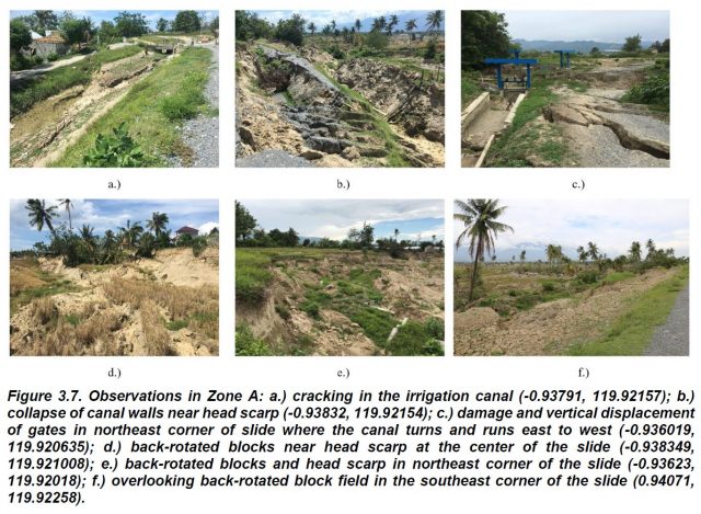
A collage of images, from the Petobo landslide, showing the deformation obsrved by the GEER team. Source: Mason et al. (2019).
.
This is an incredibly useful and interesting initial report. Detailed analysis is needed of each of these four major landslides, but the role of the irrigation canal in the initiation of the landslides has important implications elsewhere.
Reference
Mason et al. 2019. Geotechnical Reconnaissance: The 28 September 2018 M7.5 Palu-Donggala, Indonesia Earthquake. GEER-061. doi:10.18118/G63376
9 April 2019
Eco-Safe Roads – resources to guide construction
Eco-Safe Roads – resources to guide construction
Following my recent post on the need for properly engineered roads in high mountain areas, such as Nepal, Karen Sudmeier contacted me to highlight the work that she and her colleagues have undertaken on eco-safe roads. This work is featured in a piece on the IUCN website, featuring the use of bioengineering for improving slope stability along mountain roads. Bioengineering is not new, and can be highly effective, but its use remains disappointingly patchy.
The most useful element of this work is a manual that they have produced entitled “Community-based bio-engineering for eco-safe roadsides in Nepal”, which aims to provide “guidance to communities and local government agencies on the occurrence, assessment and mitigation of road construction-induced landslides and erosion.” The guide can be downloaded as a PDF.
This is a genuinely fantastic document, free of technical jargon, that both identifies the issues and offers really positive guidance on how to manage them. The first part of the document describes, with diagrams, the types of hazards that might be encountered. For example, this is the section that explains the hazards associated with earthflows:-
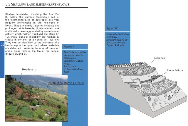
The hazards associated with earthflows, the guidelines for eco-safe roads. Reference:- Devkota et al. (2014).
.
The guidelines then provide a very helpful classification tool for measures to be considered:-
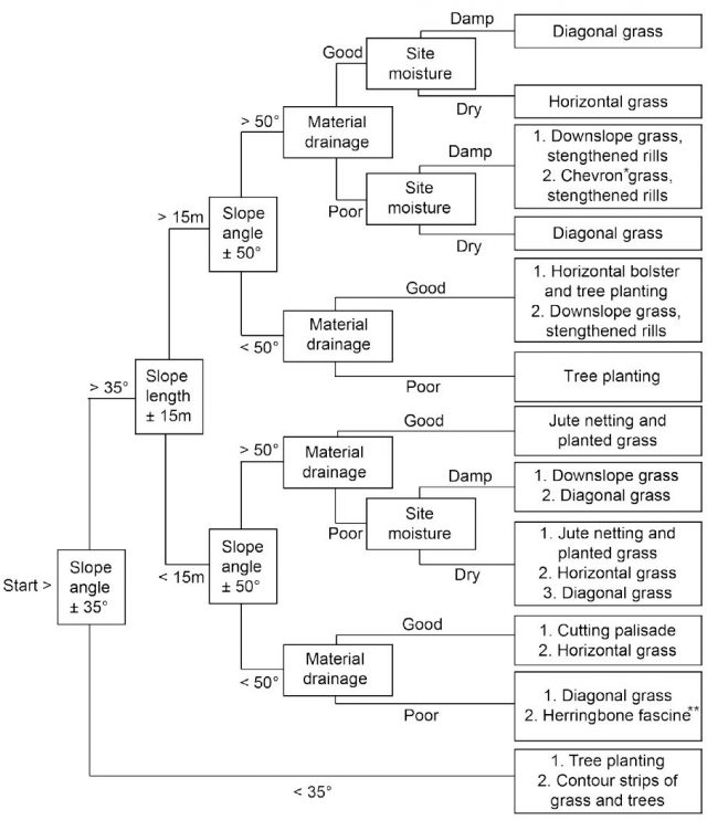
Recommended approaches for the design of eco-safe roads. Reference: Devkota et al. (2014).
.
Each of the techniques are then described in detail, including guidance on how to do it, the requirements, the advantages, the functions and the disadvantages / limitations.
I think this is a very helpful, very pragmatic set of guidelines that, if implemented, could make a huge difference. The guidelines can also be adapted easily for other locations / territories, in particular through the use of local plant species. They deserve wider recognition.
Reference
Devkota, S., Sudmeier-Rieux, K., Penna, I., Eberle, S., Jaboyedoff, M., Adhikari, A. and R. Khanal (2014) Community-based bio-engineering for eco-safe roadsides in Nepal. Lausanne : University of Lausanne, International Union for Conservation of Nature, Nepal and Department of Soil Conservation and Watershed Management, Government of Nepal.
 Dave Petley is the Vice-Chancellor of the University of Hull in the United Kingdom. His blog provides commentary and analysis of landslide events occurring worldwide, including the landslides themselves, latest research, and conferences and meetings.
Recent Comments