
20 May 2019
The Joffre Peak rock avalanches: new images
The Joffre Peak rock avalanches: new images
It is now clear that the second Joffre Peak rock avalanche last week was indeed larger by volume than the first. Images suggest that the release surface was probably an extension of the one that allowed the first landslide to occur.
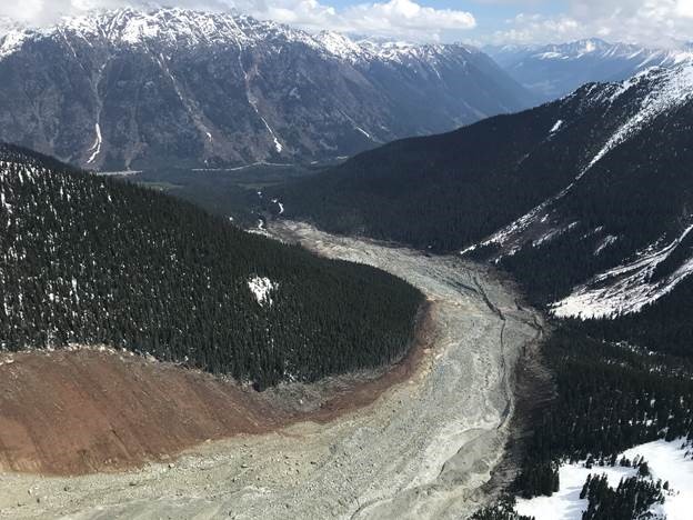
Yesterday, Lindsey Nicholson tweeted a wonderful image, taken by Wilfied Braun, showing the full extent of the second landslide:-
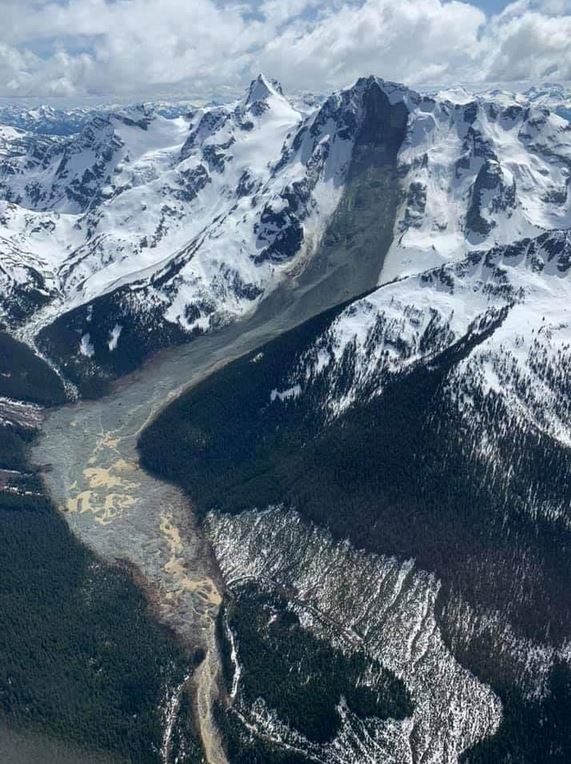
The full track of the second of the Joffre Peak rock avalanches in Canad. Image tweeted by Lindsey Nicholson, via Geomorphology rules on Facebook. Image by Wilfried Braun.
.
The larger landslide source area is evident on Joffre Peak itself, and the full, chaotic, muddy track is also clear. Interestingly there does not appear to be much super-elevation on the bend, but field work will be needed to determine this for sure.
Collecting good satellite imagery of the landslide in an area with so much cloud is difficult. Simon Gascoin tweeted a Landsat 8 image of the first of the two Joffre Peak rock avalanches. Planet Labs have captured two images of the landslides, but unfortunately neither show the full track at this point. However, they do capture the upper portion of the tracks of the two rock avalanches, allowing the scale of the two to be compared:-
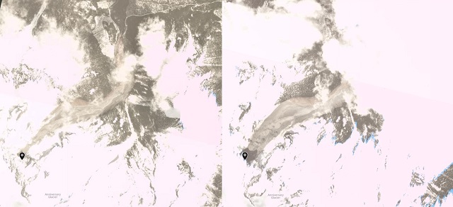
Planet Labs imagery of the Joffre Peak rock avalanches. Left hand image, PlanetScope collected 15th May 2019, right hand image PlanetScope collected 18th May. Images copyright Planet Labs, used with permission.
.
The very much larger scale of the second event, with its much broader track, is clear.
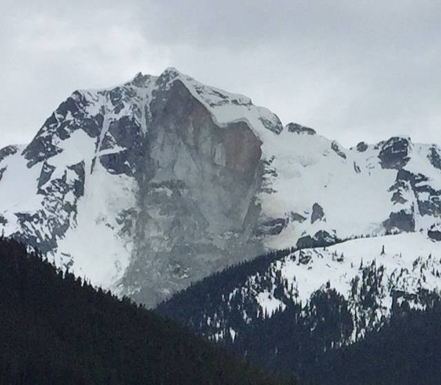
Meanwhile, there is some speculation that a further failure event is possible at Joffre Peak, given that the release surface appears to define another large rock block (see the image here to see the block that might detach). A collapse is not inevitable, but this would be a great monitoring project.
Reference
Planet Team (2019). Planet Application Program Interface: In Space for Life on Earth. San Francisco, CA.
17 May 2019
Another, probably even larger, rock avalanche on Joffre Peak
Another, probably even larger, rock avalanche on Joffre Peak
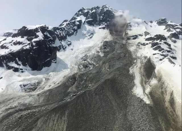
Yesterday a second, probably even larger, rock avalanche occurred on Joffre Peak in British Columbia in Canada. This event appears to have been a collapse of second major section of the steep side of the mountain, following the major event on Sunday. Many thanks to the many people who have highlighted this event to me, it is fascinating that another collapse has happened so soon after the first. Global News has a short article on the event, which includes this image, collected by Nicholas Zichy and posted to Facebook, of the landslide scar:-
The scar from the second major rockslide at Joffre Peak in Canada. Image by Nicholas Zichy on Facebook via Global News
.
The image does appear to suggest that this failure event is larger than the original last Sunday. The collapse was picked up on the regional seismic network. A tweet by John Cassidy indicates that it was detected by the seismic stations at Whistler, Lillooet, and Hope, with the event happening at a little after 9 pm on 16th May 2019.
It is likely that this landslide will have had a significant runout, but the timing of the landslide means that as yet there is no available data on this at the time of writing. Hopefully the landslide track will be flown by helicopter or drone today, or it may be visible in a satellite image, cloud permitting.
Ordu: a major slump type landslide in Turkey
Ordu: a major rotational landslide in Turkey
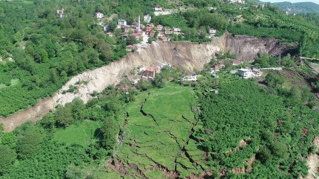
News reports suggest that on Thursday 16th May a major slump type landslide occurred at Aybasti in Ordu in northern Turkey. The best images of this very substantial landslide are on Twitter – the Daily Sabah tweeted this overview of the landslide after failure:-
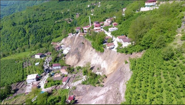
The major rotational landslide at Aybasti in Ordu in northern Turkey on 16th May 2019. Image tweeted by the Daily Sabah.
.
The displaced block is at the foot of the scarp, such that all of the properties oat the toe of the slope have slid vertically by 30 m or more. The Daily Sabah has another very clear image from the opposite view:-
The major rotational landslide at Aybasti in Ordu in northern Turkey on 16th May 2019. Image tweeted by the Daily Sabah.
.
News reports suggest that 53 buildings, including 31 houses, have been destroyed, as has a mosque. Fortunately the site had already been evacuated because of earlier movements – clearly the properties at risk extend well beyond the block that has moved. Based upon the images, I believe that this is the location on Google Earth:-
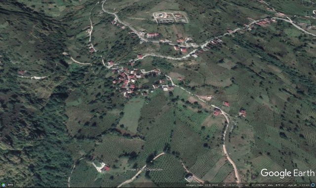
Google Earth imagery of the likely site of the landslide at Ordu in Turkey on 16th May 2019.
.
If so the location is 40.672, 37.379. Interestingly, Planet Labs have caught the landslide in action, or shortly after it slipped, on one of their Planetscope images. The two images below show the affected area on 14th May 2019 at 07:53 UTC and on 16th May 2019 at 06:55 UTC. The latter image shows the development of the large scarp across through the village, and the displaced block:-
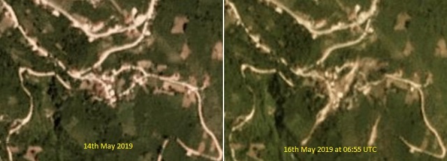
Planet Labs images of the site of the landslide at Aybasti in Ordu, Turkey. Images copyright Planet Labs 2019, used with permission.
.
It will be interesting to view the next image in the sequence to see if further movement occurred after the image was collected.
Reference
Planet Team (2019). Planet Application Program Interface: In Space for Life on Earth. San Francisco, CA.
16 May 2019
A major, fatal retaining wall failure from Basaksehir in Istanbul, Turkey
A major, fatal retaining wall failure from Basaksehir in Istanbul, Turkey
On Tuesday 14th May 2019 a major retaining wall failure occurred in the Basaksehir district of Istanbul in Turkey. The retaining wall was built on a steep slope between a housing complex and a busy road in the Kayaşehir neighbourhood. This image, from Daily Sabah, shows the aftermath of the collapse:-
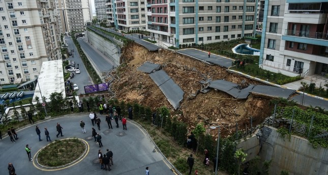
The aftermath of the retaining wall failure in the Kayaşehir neighborhood of Basaksehir district in Istanbul, Turkey on 15th May 2019. Image by DHA Photo via the Daily Sabah.
.
There is a video of the collapse caught by CCTV on Youtube. This shows that a car was caught in the event, so I advise some discretion in viewing it:-
.
The video shows that the wall underwent a toppling failure – some precursory movement can be seen in the film, such that the car was engulfed completely. There were two occupants of the car, one of whom survived with injuries. Sadly the other, named in the media reports as Fatih Göztepe, was killed.
Interestingly, the collapse occurred without a rainfall trigger, or of obvious signs of construction work. The Daily Sabah report suggests that signs of movement were evident prior to the failure:-
“Following the incident, locals told reporters at the scene that they had alerted officials to cracks in the wall but no measures were taken. In footage that emerged Wednesday and was reportedly captured a couple of days earlier, a child living in the housing development complex walks on the sidewalk and films the cracks between the road and the wall. In the video, the child says the cracks have grown larger since he last came, saying that the wall will collapse if it continues like this. He is then heard talking to the driver of a passing vehicle, warning the driver of the condition of the wall.”
Inevitably there is going to be a focus on the design and construction of the wall, and on why no action was taken when the cracks were observed.
15 May 2019
Joffre Peak: a significant rock avalanche in Canada
Joffre Peak: a significant rock avalanche in Canada
Update: an even larger rock avalanche occurred on Joffre Peak on 16th May 2019.
On Monday morning (13th May 2019) at 07:41 am local time, a significant rock avalanche occurred at Joffre Peak in British Columbia in Canada. This has been well-reported in the local newspapers – for example, City News 1130 has a good report, including links to seismic data that recorded the event. Chris Christie posted this image of the source of the landslide and the initial part of the track:-
The source and initial track of the rock avalanche at Joffre Peak. Image by Chris Christie, South Coast Touring Facebook Group via Reddit
.
Meanwhile, BC Parks have released this image of the track of the rock avalanche at Joffre Peak:-
The track of the rock avalanche at Joffre Peak in Canada. Image via the BC Government.
.
Dr Drew Brayshaw has undertaken an initial analysis of the landslide, and tweeted that the failure area was about 25,000 – 30,000 m², based on a failure geometry of a block approximately 200 m high and 150 m wide. The runout distance was about 4.2 km. The location is 50.343, -122.446 if you want to take a look in Google Earth. The landslide is likely to have entrained a large volume of material along its track, although we will need to wait for good satellite images until this can be determined properly. No lives have been lost, but there has been some disruption to power supplies.
Once again we see a large rock avalanche in a high mountain area in the spring time, so it is logical to think that this might have been associated with melting ice in the rock mass. Interestingly, British Columbia has been experiencing unusually high temperatures – on Thursday last week a number of temperature records were broken, with temperatures in some locations reaching 30 C.
British Columbia experiences frequent large landslides – notable events include the 2012 Johnsons Landing landslide and the dramatic 2010 Meager Creek rock avalanche.
Update: an even larger rock avalanche occurred on Joffre Peak on 16th May 2019.
13 May 2019
Tailings dam failures: an interesting perspective article in Science
Tailings dam failures: an interesting perspective article in Science
Late last week the journal Science published a very interesting Perspective article (Santamarina et al. 2019) on tailings dam failures. The gist of the article is summarised in this part of the conclusion:
“Given the number of tailings and ash impoundments around the world and their historical failure rate, more failures can be anticipated. The situation is aggravated by the tragic consequences often faced by the populations living downstream from the impoundment. Each incident prompts us to gain better physical insight, improve engineering practices, and implement regulations to minimize the potential for future catastrophes.”
It argues that given the number of tailings facilities worldwide (over 9000), there is an urgent need to gain a better understanding of the mechanisms of tailings dam failures, and to use this understanding to improve management practices. The urgency of this problem is illustrated by this diagram, from the article, showing volumes released, and losses of life, from tailings dam failures (with data from the fantastic World Mine Tailings Failures site):-
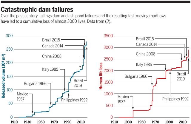
Losses from tailings dam failures, showing cumulative released volume and resulting loss of life. From Santamarina et al. (2019) via Science.
.
The article makes a couple of really interesting points. The first is that there is increasing evidence that our understanding of the failure mechanisms of tailings may be imperfect. In particular the Brumadinho failure challenges the concept that tailings stability increases with time, given that it had been decommissioned three years before the collapse. They suggest that a part of this might be the challenges in replicating in the laboratory processes that occur in real conditions over years or even decades. Santamarina et al. (2019) suggest that fly ash, for example, might undergo chemical changes shortly after deposition that leads to the grains becoming cemented together, preserving high porosity. This makes the material brittle and prone to collapse, inducing liquefaction.
But second, despite this imperfect understanding, Santamarina et al. (2019) note that most tailings dam failures are the result of poor management and regulation. They note for example that:
“At Brumadinho, the filling of the tailings dam appears to have proceeded without clear tailings disposal guidelines between 1976 and 2005, a departure from sound engineering practice.”
I have highlighted before the unacceptable rate of tailings dam failures. This article calls for a twin track approach of research to understand failure mechanisms (noting of course that translation of that knowledge into practice is essential, but not always simple) and improved management / regulation. It is hard to argue against that conclusion.
Reference
Santamarina, JC., Torres-Cruz, L.A. and Bachus, R.C. 2019. Why coal ash and tailings dam disasters occur. Science, 364 [6440], 526-528. DOI: 10.1126/science.aax1927
9 May 2019
Rock avalanche mobility is controlled by the characteristics of material in the path of the flow
Rock avalanche mobility is controlled by the characteristics of material in the path of the flow
Rock avalanche mobility is one of the most intriguing aspects of landslide behaviour. It has long been recognised that this type of landslide tends to travel faster and further than would be expected from simple friction parameters. There has been a huge amount of debate as to the causes of this behaviour, with multiple theories having been proposed, some of which have been quite exotic. To date no consensus position has emerged, and the debate rages on.
In a new contribution to the discussion on rock avalanche mobility, a paper in the journal Engineering Geology (Aaron and McDougall 2019) examines 45 well constrained rock avalanche case histories to better understand the controls on their runout. Their work used a semi-empirical modelling approach to back analyse the mobility of the landslides, testing a series of hypotheses centred on the idea that rock avalnche mobility is controlled, at least in part, by interaction with the basal materials that they encounter along their path. This is perhaps most easily imagined in the context of flowing over glacial ice, such as in this beautiful example:
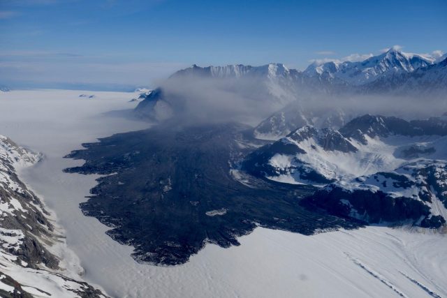
The Lamplugh Glacier rock avalanche via Paul Swanstrom.
In this case, flowing over a very low friction ice surface might be expected to increase rock avalanche mobility. The same might also occur where the landslide encounters loose, saturated materials, but perhaps to a lesser degree.
The authors conclude that for many of these landslides their behaviour can be best modeled by assuming that the frictional rheology / resistance of the landslide changes in the transition from the source zone to the runout path. In general where the rock avalanche ran across bedrock, the resistance to motion was found to be high, but where the path traversed ice or a saturated substrate the resistance to motion was found to be much lower.
The results are a really interesting contribution to the debate. This matters as high mobility rock avalanches can have a devastating impact on communities and infrastructure, and unsurprisingly there is increasing interest in trying to forecast likely behaviour. As the authors state:
“…forecasts must parameterize the relationship that governs the basal resistance the rock avalanche experiences during emplacement…this choice must account for the expected shear characteristics of the path material”
Reference
Aaron, J. and McDougall, S. 2019. Rock avalanche mobility, the role of path material. Engineering Geology. https://doi.org/10.1016/j.enggeo.2019.05.003
8 May 2019
Hargraves Crater: is this a landslide on Mars? Your views please
Hargraves Crater: is this a landslide on Mars? Your views please
Yesterday the NASA HiRISE team posted an image that they described as a “Distinctive Lobe of Northern Hargraves Crater Ejecta Blanket“. This is the salient part of the image:-
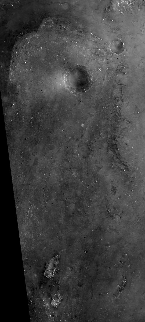
“Distinctive Lobe of Northern Hargraves Crater Ejecta Blanket“. Image via NASA/JPL/University of Arizona.
.
On Twitter, Andrew Wiebusch raised the possibility that this is not an ejecta blanket, but is instead a sign of slope instability:-
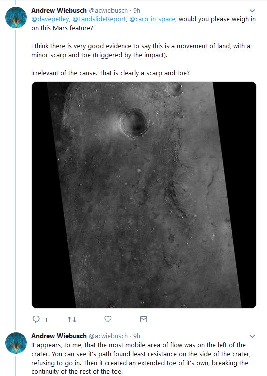
Tweets from Andrew Wiebusch regarding the possibility that a feature at Hargraves Crater on Mars is a sign of slope instability
.
I am no expert on landslide features on Mars (or on other planetary bodies), but I can understand the interpretation that Andrew is making. There appears to be a large arcuate scar, and ridges occur within this that look like tension features and scarps. The main body of the feature appears to be disrupted compared with the surrounding topography, much as landslides on Earth develop distinctive disrupted hummocky terrain. The main landslide body appears to lie within, and flow from, a bowl-shaped feature .
My strong sense is that such a feature on Earth would be interpreted as a sign of past slope instability, assuming that the regional slope coincided with the observed landslide topography (I have no sense of the regional slope in this case). However, I am more hesitant about making such an interpretation for a feature on Mars. So your views are welcome via the comments. Do you agree that this might be a landslide? If so, why do you make this interpretation? If not, what are the features that differentiate this from a slope instability?
The comments are moderated (to try to avoid the deluge of spam that the blog attracts), so please be patient as it might take a few hours for your post to appear. Unfortunately my day job gets in the way of the important things in life ;-).
7 May 2019
Bajo Llojeta landslide: a high resolution Planet Labs SkySat image
The Bajo Llojeta landslide: a high resolution Planet Labs SkySat image
Last week I featured the remarkable and dramatic Bajo Llojeta landslide in La Paz, Bolivia, which destroyed many houses. Planet Labs have kindly tasked a SkySat satellite to collect a high resolution image. This was obtained on 4th May 2019:-
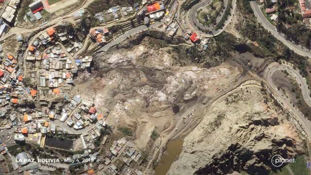
Planet Labs SkySat image of the site of the Bajo Llojeta landslide in Bolivia. Image collected by Planet Labs SkySat, used with permission. © Planet Labs 2019.
.
It is worth comparing this image with the Google Earth imagery of the site prior to the landslide. I have tried to capture the same area:-
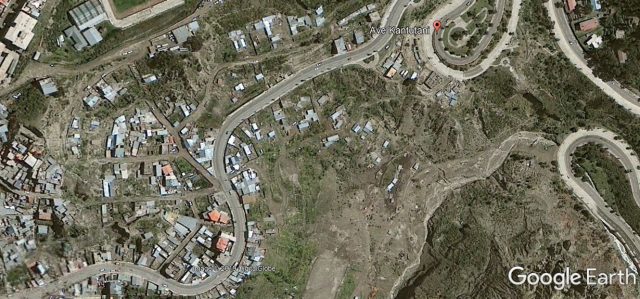
Google Earth image of the site of the Bajo Llojeta landslide in Bolivia. Image collected by Digital Globe on 13th February 2013. © Google Earth / Digital Globe 2019.
.
The image captures the scale of the landslide and the level of destruction to the buildings. The landslide is clearly an earthflow type event, with a retrogressive rotational back scarp, showing multiple phases of movement. The deposit on the road at the toe has been cleared away, and earth moving equipment can be seen on the southern edge of the landslide near to the toe. A substantial number of properties are at severe risk in the vicinity of the head scarp.
An article on Los Tiempos indicates that an additional 22 houses in the headscarp area will need to be demolished, in addition to the 68 homes lost in the Bajo Llojeta landslide. In total this affects at least 180 families and 431 people. The local government has apparently promised to rehouse the affected people, and I very much hope that this will happen. In my experience such promises are often not delivered, unfortunately.
Reference and acknowledgement
Planet Team (2019). Planet Application Program Interface: In Space for Life on Earth. San Francisco, CA.
Thanks to Robert Simmon for help in acquiring the SkySat image.
3 May 2019
Bajo Llojeta: a major landslide, with dramatic videos, in La Paz, Bolivia
Bajo Llojeta: a major landslide, with dramatic videos, in La Paz, Bolivia
Over the last few days, but primarily on 30th April 2019, a major landslide affected the community of Bajo Llojeta in La Paz, Bolivia. There are a number of dramatic videos of this event, most of which have featured the collapse of houses as the rear scarp of the landslide has undergone retrogression. In fact the most remarkable videos capture the main body of the landslide. This is an astonishing example that captures the movement of the toe of the landslide, with some sense of the damage in the urban area:-
.
From this video it is clear that this is a very large, rapid (for this type of landslide), retrogressive earthflow. The damage to the properties involved in Bajo Llojeta is total. News reports suggest that 64 houses were destroyed, affecting 88 families. The retrogressive nature of the landslide might well mean that further properties will be at risk. The destructive nature of the landslide is well-captured in this video:-
.
Note the movement event from about 2 minutes into the film, possibly caused by a rotational failure in the back scarp that then triggered an undrained loading event in the main landslide deposit?
There is a very interesting aspect to this landslide that is well-captured in the above video, and shown in the screenshot below:-
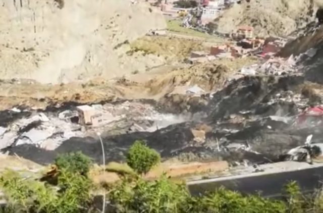
The landslide at Bajo Llojeta in La Paz, showing the remains of the landfill in the landslide debris. Still from a video posted to Youtube
.
The material involved here is very black, and is clearly different from the surrounding geology. There is an explanation for this in a news report (in Spanish – translated by Google):-
As explained by the mayor of the city, Luis Revilla, “the land was mixed with old rubbish” and there was “a strong infiltration of water in the cracks of the landslide started in San Jorge Kantutani”. No fatalities have been reported, but two have disappeared. According to preliminary data, the landslide has affected 88 families and left 64 homes damaged.
So it appears that this was an unplanned settlement built on a landfill site. The reports indicates that there were significant inadequacies in the local drainage and sewerage system. This may have had a cumulative effect – i.e. initial movement of the landslide disrupted the drainage, allowing water to enter the slope, which deformed, and so on.
The location of the landslide is -16.519, -68.121. This is a Google Earth image of the site, I believe:-
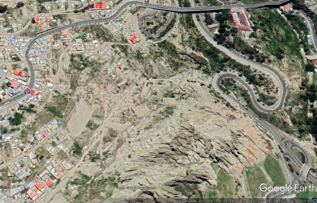
Google Earth imagery of the site of the landslide at Bajo Llojeta in La Paz, Bolivia. Image from April 2019.
.
Fortunately there are no reported fatalities from this landslide. Landslides are common in La Paz, this thesis by Nick Roberts explains the setting (this is the abstract, the full thesis can be downloaded:-
“La Paz lies in a deeply incised valley on the Bolivian Altiplano. It has experienced frequent damaging historic landslides and numerous, much larger, prehistoric landslides…The upper part of the sediment sequence beneath the Altiplano is glacial in origin and fines distally away from the Cordillera Real. It records at least 15 late Pliocene and Early Pleistocene glaciations, most of which predate the oldest known North American continental glaciation. The plateau surface formed by ca. 1.0 Ma, but most likely before ca. 1.8 Ma. After that the headwaters of the Amazon River extending westward through the Cordillera Real incised the underlying sediments. The poorly lithified fill sequence is exposed in steep slopes, promoting instability. Between 1995 and 2014, La Paz experienced 43 discrete landslides and slow ongoing landslides at 13 additional locations. Landslides were most frequent late in the rainy season and generally happened after particularly wet periods weeks in length, indicating a strong hydro-meteorological control.”
 Dave Petley is the Vice-Chancellor of the University of Hull in the United Kingdom. His blog provides commentary and analysis of landslide events occurring worldwide, including the landslides themselves, latest research, and conferences and meetings.
Recent Comments