
10 April 2019
GEER report on the Palu landslides
Posted by Dave Petley
GEER report on the Palu-Donggala landslides
The GEER team that travelled to examine the Palu-Donggala landslides, triggered by the 28 September 2018 Mw=7.5 Palu earthquake in Indonesia, have now published and made available their report (Mason et al. 2019). This is, as far as I am aware, one of the first detailed published reviews of these intriguing but terrible flowslides.
The report is detailed and well-curated, providing insight through both field observation and eye-witness reports. There is far too much to cover in a single post, so I will highlight what I consider to be the key take-home messages:
1. The report confirms that there were four major flowslides triggered by the earthquake (the team also surveyed a smaller landslide in the same area), inflicting huge losses on the communities in the local area. These are shown in the image, from Mason et al. (2019), below:
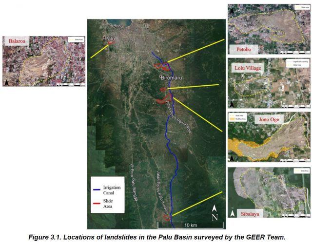
Locations of Palu-Donggala landslides surveyed by the GEER Team (Source: Mason et al. 2019).
2. The team estimate that 80% of the 4340 fatalities caused by the earthquake were the result of these four flowslides, confirming that this is the worst landslide disaster in the last five years.
3. The team note that the landslides occurred on very low angled slopes. Typically these were in the range of 2 to 4% grade.
4. Field observations confirm that these landslides were the result of extensive liquefaction, triggered by the earthquake shaking. The team observed sand boils at the landslide sites, and in the surrounding areas, which is a diagnostic feature of liquefaction processes.
5. But interestingly, and importantly, the team conclude that thee of the four landslides were associated with unlined canals located in the headscarp areas. As the team pit it in the summary of the report.
“An unlined irrigation canal forms the upper boundary or crest of slides that occurred on the eastern side of the Palu basin. The canal contributed to saturation of the ground (typically used as agricultural fields and rice paddies) at these locations, where the groundwater table would otherwise be at greater depths. The canal was breached by the landslides at several locations and contributed water to later stage mudflows at some locations. Thus, the canal is believed to have played a critical role in the initiation and progression of the landslides on the east side of Palu basin.”
This collage of images, from the report, shows the damage to the canal, and some of the downslope deformation, from the Petobo landslide:
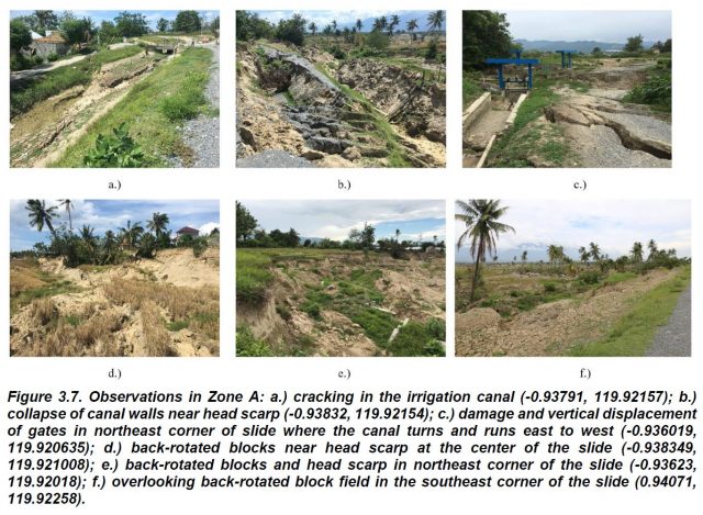
A collage of images, from the Petobo landslide, showing the deformation obsrved by the GEER team. Source: Mason et al. (2019).
.
This is an incredibly useful and interesting initial report. Detailed analysis is needed of each of these four major landslides, but the role of the irrigation canal in the initiation of the landslides has important implications elsewhere.
Reference
Mason et al. 2019. Geotechnical Reconnaissance: The 28 September 2018 M7.5 Palu-Donggala, Indonesia Earthquake. GEER-061. doi:10.18118/G63376
 Dave Petley is the Vice-Chancellor of the University of Hull in the United Kingdom. His blog provides commentary and analysis of landslide events occurring worldwide, including the landslides themselves, latest research, and conferences and meetings.