26 March 2019
NASA Earth Observatory imagery of the Chimanimani landslides in Zimbabwe
Posted by Dave Petley
NASA Earth Observatory imagery of the Chimanimani landslides in Zimbabwe
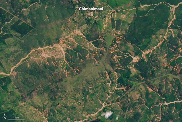
Yesterday NASA posted imagery of the Chimanimani landslides in Zimbabwe, triggered by Cyclone Idai. Last week I highlighted that initial imagery suggested that there had been significant levels of landsliding; the NASA imagery confirms this. The image below shows the landslides around Chimanimani itself, captured with Landsat 8 Operational Land Imager (OLI) instrument:-

NASA Landsat 8 OLI image of the Chimanimani landslides in Zimbabwe, triggered by Cyclone Idai.
.
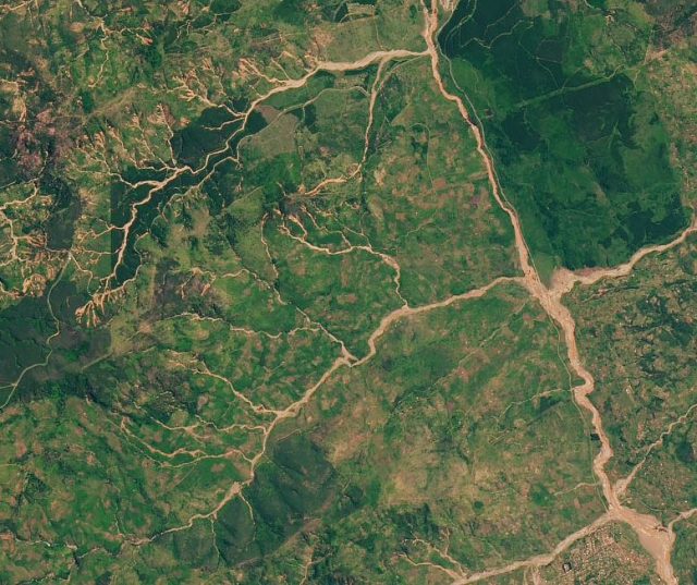
The imagery clearly confirms that this area suffered extensive shallow landslides in the upper part of the catchments, which in turn combined to generate channelised debris flows that affected the villages. These landslides have occurred over a wide area, beyond the zone shown in the image above (which has received most of the attention), as seen from the image below showing the area to the southwest of Chimanimani:-

NASA Landsat 8 OLI image showing landslides to the southwest of Chimanimani in Zimbabwe, triggered by Cyclone Idai.
.
Note also the extensive evidence of sediment-rich floods in the main channel, which illustrates the way in which landslides high in the catchment can cause extensive damage long distances downstream.
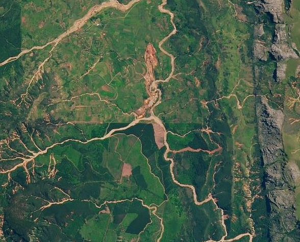
The largest of the Chimanimani landslides appears to lie to the east of the town itself:-

NASA Landsat 8 OLI image showing the largest of the Chimanimani landslides, triggered by Cyclone Idai.
.
This is a slightly intriguing feature that will benefit from more detailed investigation.
Meanwhile work continues to assess the losses from these landslides. On 24th March, reports suggested that the known fatalities from the Chimanimani landslides had reached 189, although the final total was expected to be double this number. There are some harrowing tales of the events that night; this is an account from Chipo Dhliwayo:-
“Rocks came from the mountain and crushed our hut; my in-laws’ house was the first to be destroyed. When our hut fell, my husband had gone to help my in-laws,” said Dhliwayo, as Zimbabwe military helicopters with aid and relief arrived at the worst affected areas of Chimanimani days after the tragedy.
“I had three children that were sleeping in the house and I managed to rescue only my six-month-old child on my own before my husband arrived back.
“When he got back, I was crying and trying to move some of the rocks covering our hut to rescue our four-year-old kid, who survived. But the other child did not come out alive; he died in the hut, trapped under large stones,” she said.


 Dave Petley is the Vice-Chancellor of the University of Hull in the United Kingdom. His blog provides commentary and analysis of landslide events occurring worldwide, including the landslides themselves, latest research, and conferences and meetings.
how much did deforestation exacerbate the landslide problem?
The large landslide east of Chimanimani is mainly a government diamond mine that spans the Haroni River.
Initial mine was in the loop to the west ; newer section is going north from the loop; section Sw of the loop and north on the next river junction are slimes dams.