5 October 2018
Indonesian earthquake: loss maps from the Palu landslides, and large landslides to the south of the city
Posted by Dave Petley
Indonesian earthquake: loss maps from the Palu landslides
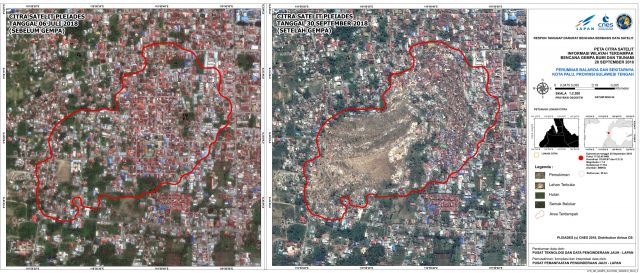
A notable aspect of the Indonesian earthquake has been the rapid availability of large amounts of satellite data, greatly assisted by the effective activation of the International Charter Space and Major Disasters. The data is now being analysed by agencies around the world. LAPAN have been using the data to map the losses from the landslides in Palu. The results are fascinating and dreadful. This is their before and after comparison for the landslide at Balaroa:-

Indonesian earthquake:- before and after imagery of the Balaroa landslide. Image Copyright: Pleiades © CNES (2018), Distribution: Airbus DS. Map produced by LAPAN.
.
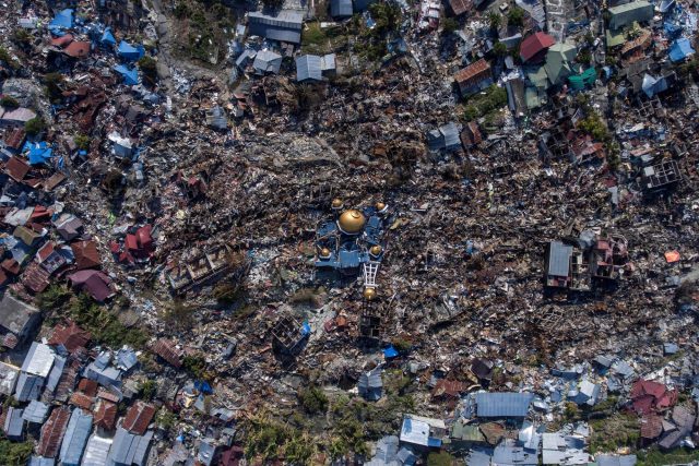
The number of houses destroyed by the landslide is very high – some reports suggest about 1,700 homes in the Balaroa area alone. Similar maps are being produced for the other landslides. Interestingly, Reuters have an article about the earthquake damage that includes some excellent graphics, including detail about the landslides. However, the images of the site show the full magnitude of the damage:-

Indonesian earthquake: landslide damage at Balaroa. Image by Antara Foto/ Hafidz Mubarak A/ via Reuters.
.
The article quotes Sutopo Purwo Nugroho, spokesman for the National Disaster Mitigation Agency: “We don’t know how many victims could be buried there, it’s estimated hundreds”.
.
Indonesian earthquake: large landslides to the south of the city
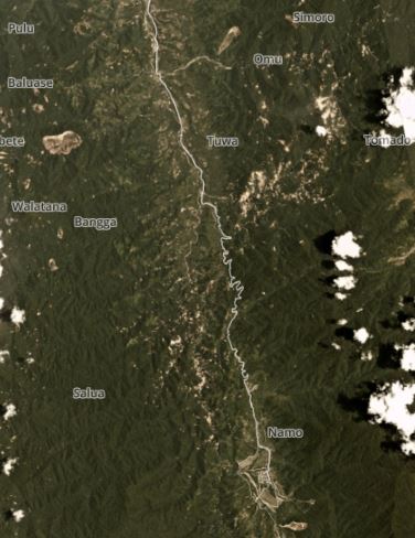
Meanwhile, to the south of Palu there is an area of reasonably dense landslides, as shown in the Planet Labs imagery:

Planet Labs image of landslide south of Palu. Image courtesy of Planet Labs, used with permission.
.
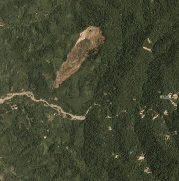
In this area the fault passes through hilly terrain; for the mostpart the landslides appear to be close to the fault trace. There are some large landslides in this area, although these are more conventional failures than was the case in Palu. This landslide for example appears to be a reasonably deep-seated slip that is about 800 m long:-

Indonesian earthquake: an example of a larger landslide to the south of Palu. Image courtesy of Planet Labs, used with permission.
.
This landslides, and indeed most in this area, did not have the high mobility of the landslides in Palu, and so are probably not liquefaction-initiated flowslides.
Reference
Planet Team (2018). Planet Application Program Interface: In Space for Life on Earth. San Francisco, CA. https://www.planet.com/explorer/


 Dave Petley is the Vice-Chancellor of the University of Hull in the United Kingdom. His blog provides commentary and analysis of landslide events occurring worldwide, including the landslides themselves, latest research, and conferences and meetings.
An interesting view of the head “scarp” of one of the slides in Palu area (is it the Potobo slide, based on the lack of buildings above the slide?) in a BBC article: https://ichef.bbci.co.uk/news/976/cpsprodpb/042A/production/_103666010_hi049701178.jpg