30 April 2019
Bashkara Glacier: a major rock avalanche in the Caucasus last week
Posted by Dave Petley
Bashkara Glacier: a major rock avalanche in the Caucasus last week
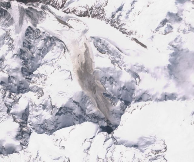
Three days ago, Михаил Докукин, a geohazard researcher on the Caucasus mountains at the High Mountain Geophysical Institute in Nalchik, Russia tweeted an image from the Bashkara Glacier in Russia. The Bashkara Glacier is suffering significant retreat, at rates of up to 8 m per year according to my fellow AGU Blogger, Mauri Pelto. This is ascribed in large part to higher summer temperatures. The tweet by Михаил Докукин uses ESA Sentinel imagery to show the deposit from a large rock avalanche in the upper reaches of the Bashkara Glacier. The location is 43.188, 42.741 if you want to take a look. This is the Sentinel image:-

Sentinel imagery showing the major rock avalanche on the Bashkara Glacier. Image collected by ESA Sentinel on 25th April 2019, obtained via Sentinel Hub.
.
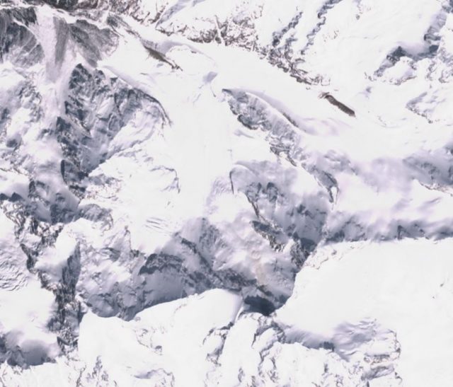
This landslide deposit is not visible on the image from two days previously:-

Sentinel imagery showing the site of the major rock avalanche on the Bashkara Glacier. Image collected by ESA Sentinel on 23rd April 2019, obtained via Sentinel Hub..
.
At this point there is no further information as to the timing of the landslide, although it should have registered a signal on the local seismic network. The landslide appears to be about 2.7 km from source to toe, and to have generated a deposit that is about 550 metres wide at its maximum. The source appears to be the collapse of the steep rock wall at the head of the glacier, and there is just a hint of some debris and dust in this area in the image of 23rd April, suggesting that the collapse may have had some precursory activity. In terms of mechanism, this landslide appears to be similar to the 2013 Mount Haast collapse, which was captured on the famous video. The Mount Haast event had a runout distance of 2.9 km, so broadly similar to this event. The deposit volume for that event was 2 million m³.
The Bashkara Glacier event has generated a significant amount of dust in addition to the main landslide deposit, which also suggests a rock avalanche. Unfortunately of course the deposit will be rapidly covered by new snowfall, rendering the landslide difficult to study in detail.


 Dave Petley is the Vice-Chancellor of the University of Hull in the United Kingdom. His blog provides commentary and analysis of landslide events occurring worldwide, including the landslides themselves, latest research, and conferences and meetings.
The post-rockfall image shows much more bare earth around the edges of the cirque-like feature above the rockfall (and elsewhere). Early spring runoff would certainly aid this erosion event.
in scientific terms, the use of the word ‘suffering’ to describe glacial retreat is not preferred.
perhaps ‘exhibiting’ would be more neutral? since it is linked blue text, it may not be your language.
I enjoy your blog immensely and appreciate your efforts at compiling this information for all of us to see.
cheers
Runout distance of 2.7 km… what about the altitude difference from source to toe ? Because it could be interesting to calculate the energy line angle (fahrboschung), probably quite low due to high volume and runout zone onto a glacier. This last issue was a hot topic these last years in Switzerland.
Thanks for your stimulating blog.
Regards.
Eric