
3 June 2021
Not all slope failures are large
Not all slope failures are large
Inevitably, on this blog I tend to cover larger landslides most of the time. Large landslides have a greater propensity to cause loss and to disrupt, and of course they are also more newsworthy and they are frequently photogenic. However, this gives a very misleading impression of slope failures, the vast majority of which are small. Nonetheless, even these less impressive landslides can have substantial impacts.
Whilst walking around my home city of Sheffield in the current spell of warm, sunny early summer weather, I have spotted a series of smaller but interesting slope failures. I thought it would be interesting to highlight two of them.
The Sheffield and Tinsley Canal is a 6 km long waterway constructed in 1819 to link the city of Sheffield with the navigable parts of the River Don, allowing goods and people to be transported into and out of the city. Its greatest claim to fame is that the it is the location of part of the opening scenes of the film The Full Monty (although it looks considerably better than that now!).
Today the canal is navigable by pleasure craft, and the towpath forms a walking and cycle route. The image below shows a small slope failure that has occurred in a section of the canal:
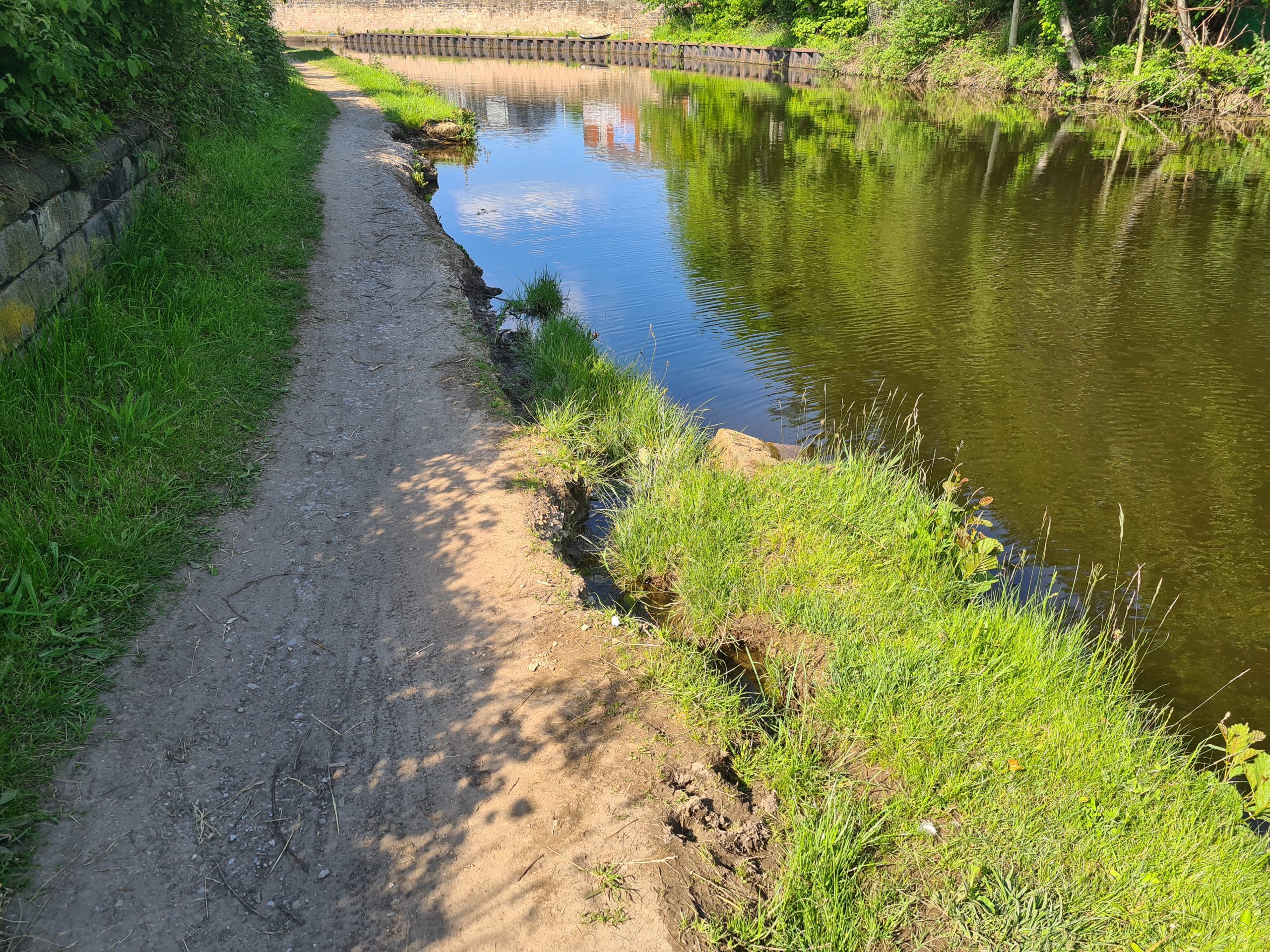
A small canal bank failure on the Sheffield and Tinsley canal
.
As the image shows, about a 15 m section of the canal bank has collapsed. In the foreground a further section is failing. In other sections of the canal, failures are developing but have not collapsed:-
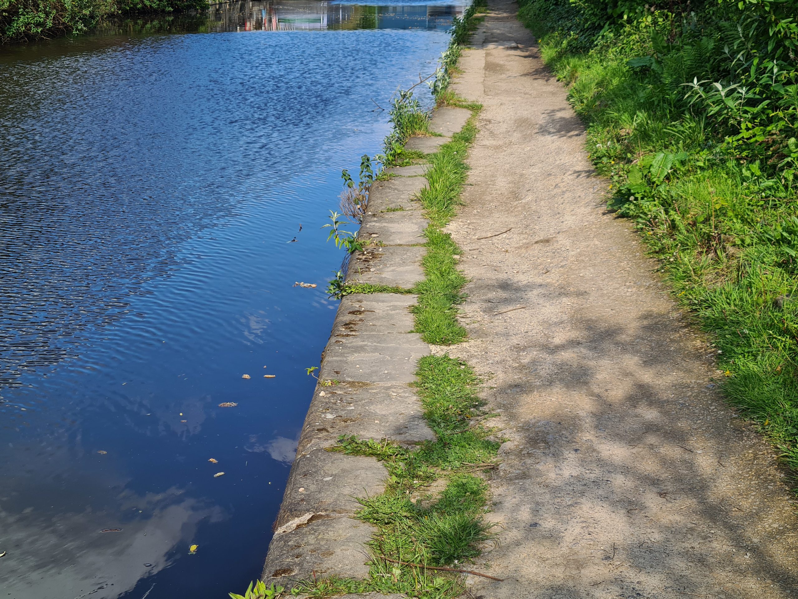
A developing canal bank failure on the Sheffield and Tinsley canal.
.
The stone blocks have moved towards the canal by about 50 cm, and the fill has subsided by about 30 cm. In this case failure, when it occurs, will substantially disrupt the towpath. There are other sections in a similar state.
None of these slope failures are large or dramatic, but they have the potential to close the towpath.
The second case lies on my walk to work. Here, at the top of a steep bank, a retaining wall has recently been constructed to create a pathway for pedestrians. It appears that this wall, which is about 50 cm high, has also started to fail and to move downslope. The owners of the site have employed a novel method to provide short term increased stability:
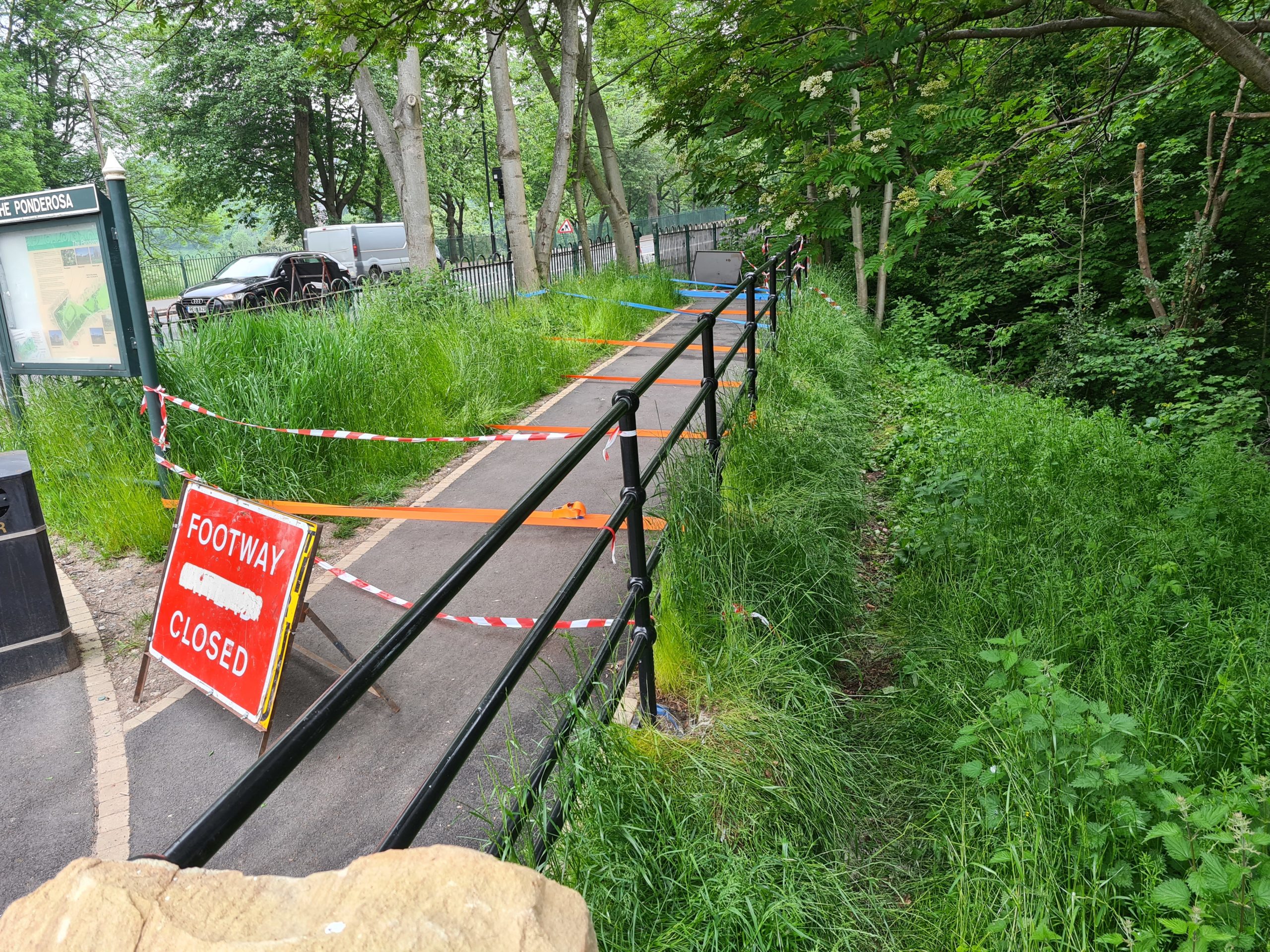
A failing retaining wall in Sheffield.
.
Securing a slope using cargo straps tied to the trees is not an approach that I have seen before. Again, this is small incipient slope failure, but one that is causing disruption.
2 June 2021
The 1918 Getå landslide disaster in Sweden
The 1918 Getå landslide disaster in Sweden
A recent post on Reddit has highlighted a landslide disaster that occurred close to the village of Getå in Sweden on 1 October 1918. The event is also well-described in a Wikipedia page.
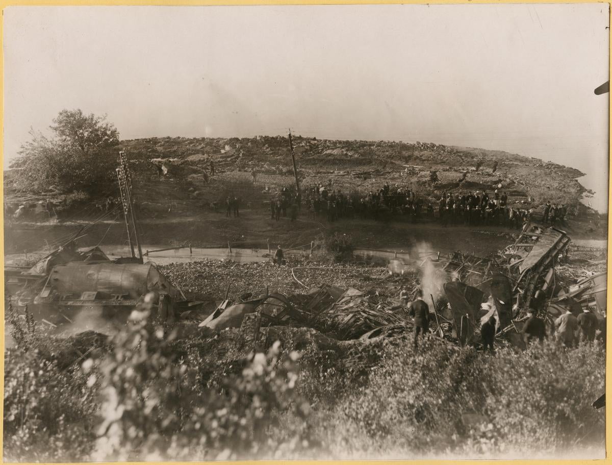
Early in that evening a landslide removed a section of a railway track. A few minutes later a train, consisting of a locomotive and ten carriages, reached the landslide and derailed spectacularly. The post on Reddit has a fascinating aerial image of the aftermath of the landslide:
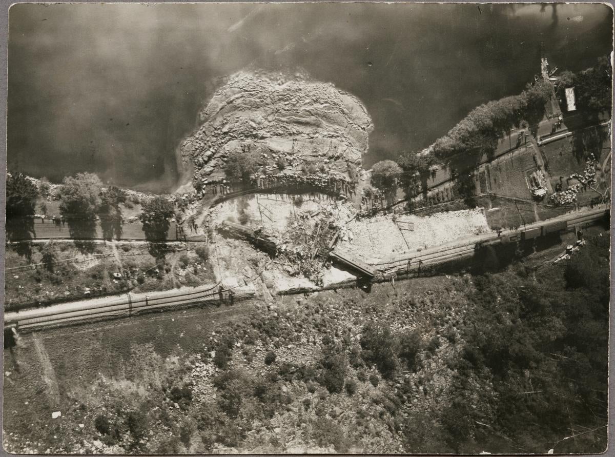
A vertical aerial photograph showing the aftermath of the 1918 landslide at Getå in Sweden. Image from Järnvägsmuseet.
.
The landslide scar and its very large deposit are clearly visible. Interestingly, the crown of the landslide seems to almost perfectly coincide with the upslope boundary of the railway line. The crashed locomotive is visible in the scar, as is one of the carriages. There us a huge pile of debris, which is the aftermath of the fire that destroyed most of the carriages. Other carriages remained upright on the tracks.
At least 42 people were killed in the accident, the majority of whom are thought to have been trapped in the derailed carriages when the fire engulfed them. A further 41 people were injured. There are thought to be at least five people who remained missing after the accident.
The image below shows the landslide deposit:-
A photograph from the crown of the slide showing the aftermath of the 1918 landslide at Getå in Sweden. Image from Järnvägsmuseet.
.
A detailed investigation of the landslide was undertaken. It concluded that there was a prehistoric landslide at the site that had not been identified at the time of the construction of the railway, five years earlier. Failure was triggered by high pore water pressures. The railway line was located on a gravel embankment; sliding initiated on the interface between the embankment gravel and the underlying clay.
The railway line was rebuilt and remains in use today; the accident spurred the development of the field of geotechnics in Sweden.
1 June 2021
Corinth Canal: a video of the rockfall that has left it closed since January
Corinth Canal: a video of the rockfall that has left it closed since January
According to Wikipedia, the Conrinth Canal, “connects the Gulf of Corinth in the Ionian Sea with the Saronic Gulf in the Aegean Sea. It cuts through the narrow Isthmus of Corinth and separates the Peloponnese from the Greek mainland“. Built in 1893, it was for a while an important trading route within Greece. However, it is a very narrow cut through bedrock – it is 6.4 km long but only 21.4 m wide at the base – meaning that many modern ships cannot pass through today. Nonetheless it is an important route for smaller tourist ships.
The Corinth Canal has suffered landslide problems since its construction. Again Wikipedia provides some detail:
Another persistent problem was the heavily faulted nature of the sedimentary rock, in an active seismic zone, through which the canal is cut. The canal’s high limestone walls have been persistently unstable from the start. Although it was formally opened in July 1893 it was not opened to navigation until the following November, due to landslides. It was soon found that the wake from ships passing through the canal undermined the walls, causing further landslides. This required further expense in building retaining walls along the water’s edge for more than half of the length of the canal, using 165,000 cubic metres of masonry. Between 1893 and 1940, it was closed for a total of four years for maintenance to stabilise the walls. In 1923 alone, 41,000 cubic metres of material fell into the canal, which took two years to clear out.
In January this year a further large rockfall occurred along the Corinth Canal. UP Stories has published an excellent video on Youtube that shows the aftermath of the rockfall, and the serious damage that it has caused:
.
The image below, from the video shows the damage that has occurred along the canal:
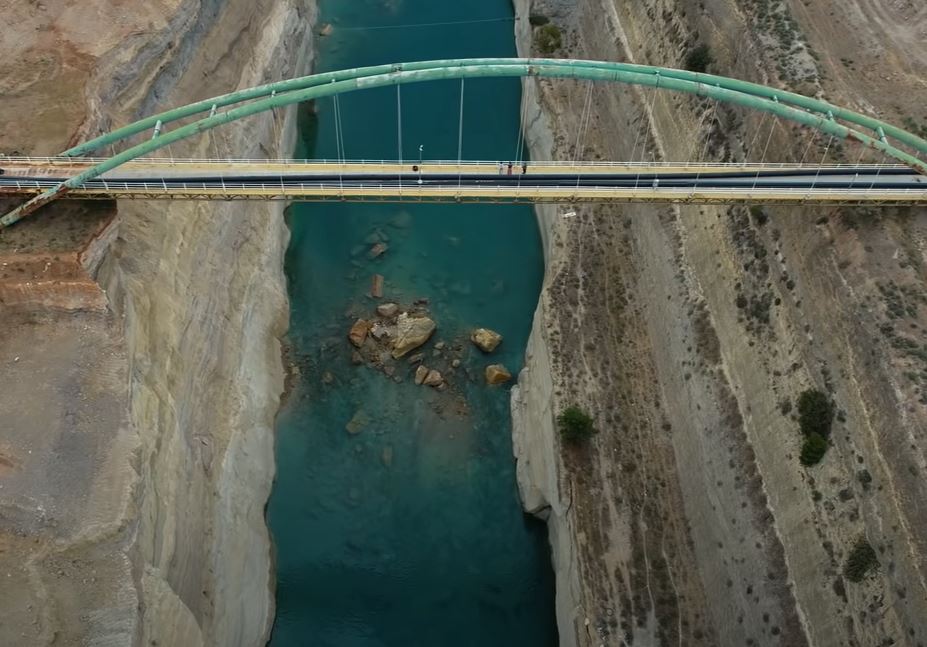
Rockfall damage on the Corinth Canal. Still from a video posted to Youtube.
.
Greek Reporter has an article about the rockfall. It seems that the collapse was caused by damage to the stone pillars supporting the slopes. The investigation is expected to last until September, after which the remediation work will start. The implication is that the Corinth Canal will remain close for many more months.
24 May 2021
Rest and Be Thankful: an update on the landslide mitigation works
Rest and Be Thankful: an update on the landslide mitigation works
Yesterday, The Scotsman newspaper posted a long and detailed article about the ongoing attempts to manage the landslide problem on the A83 at Rest and Be Thankful. I have posted frequently in recent years about the landslide problems at this site, which is undoubtedly the most challenging landslide location in the UK at the moment.
The article describes the new engineering works that have been completed to protect the diversion route lower down the hillside, the Old Military Road, which is brought into use when the main A83 route is unusable. The latest attempt to protect this road has involved the construction of a huge bund, 6 metres high and 180 metres long, on the upslope side of the Old Military Road, to capture debris from the slope above. The article includes images of this remarkable structure:-
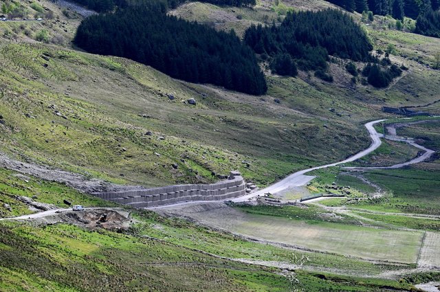
The newly constructed bund to create a retention space for debris flows above the Old Military Road at Rest and Be Thankful. Image by John Devlin via The Scotsman.
.
From the perspective of the road the structure looks like this:-
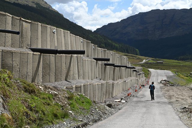
Detail of the newly constructed bund above the Old Military Road at Rest and Be Thankful. Image by John Devlin via The Scotsman.
.
Meanwhile on the main A83 road itself, catch pits are being built on the upslope side of the road to try to retain mobilised debris, and multiple flexible barriers have been constructed. At one location a flexible barrier has been constructed along the centreline of the road itself to try to protect a part of the carriageway. I have not seen that approach previously:-
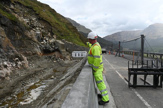
One of the catch pits and a flexible barrier on the A83 at Rest and Be Thankful. Image by John Devlin via The Scotsman.
.
The scale of these engineering works, and the construction of increasingly large structures in an area that is protected, illustrate the enormous magnitude of the challenges on the A83 at Rest and Be Thankful. Plans are progressing for the construction of an alternative alignment, but this will take several years to bring to completion. In the meantime, protecting the roads against landslides will be a mighty battle.
21 May 2021
The Pietrafitta landslide: can traffic vibration cause a landslide to move?
The Pietrafitta landslide: can traffic vibration cause a landslide to move?
Over the years I have frequently heard discussions about the triggers for landslide movement. Many of these are obvious – rainfall, seismic shaking, snowmelt, construction, for example. Sometimes people have also described vibration from traffic or trains as being a potential trigger. I have always wondered how strong the evidence is to support this assertion.
There is an interesting paper in the journal Landslides (Guerriero et al. 2021) that has investigated this for a clay landslide in Italy. The site, the Pietrafitta landslide in southern Italy, is located alongside an important road, SS87. In 2016 movement of the landslide was causing periodic closure of the road to traffic. The authors have included this image of the landslide:-
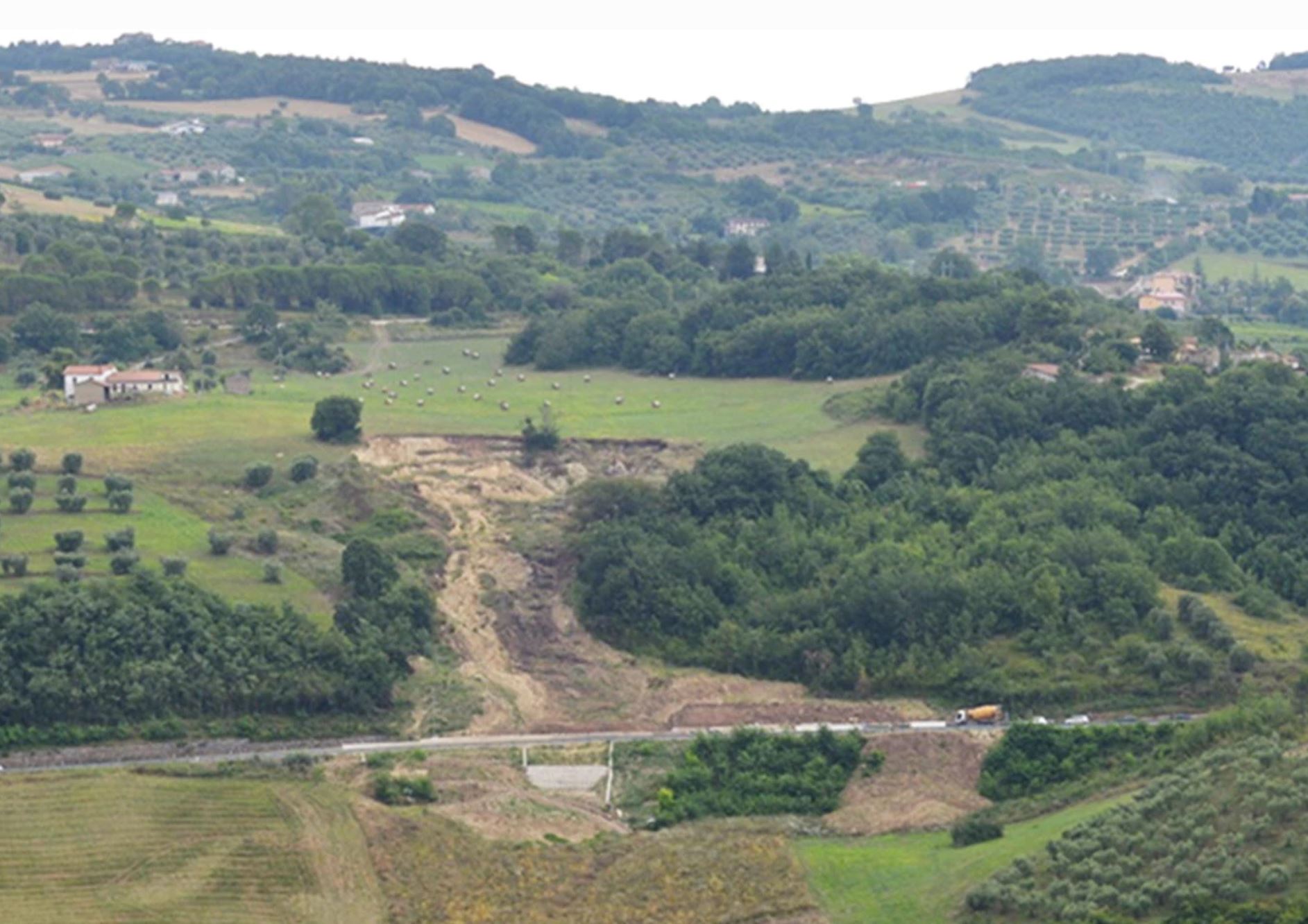
The Pietrafitta landslide. Image from Guerriero et al. (2021).
.
This is probably best described as a retrogressive earthflow. The scale of the landslide is indicated by the truck located on the right side of the landslide toe.
The authors installed a broadband seismic station to measure the traffic vibration and an extensometer to measure landslide movement. In the period of the study traffic flow on the road occurred for only a part of the day, giving a period of no traffic vibrations to compare with a period in which traffic was occurring.
The graph below shows the startling results:
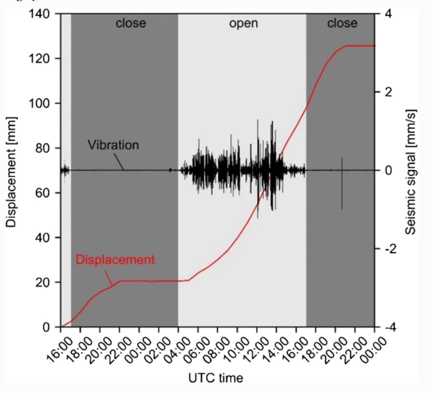
Traffic vibrations and displacement of the Pietrafitta landslide. Image from Guerriero et al. (2021).
.
When the road was closed (the dark grey periods) no traffic vibrations were recorded. Movement of the landslide typically slowed and stopped. In the period in which traffic was flowing (the light grey periods) the landslide commenced movement, with a period of acceleration. After the traffic ceased the landslide continued to move for some hours before slowing and eventually stopping.
Guerriero et al. (2021) hypothesise that the landslide was probably on the very margin of instability in its natural state (i.e. the factor of safety was very close to one). The traffic vibration generated higher pore water pressures on the shear surface, which were enough to lower the factor of safety below one, allowing movement to start. Once the traffic ceased the higher pore water pressures took a few hours to dissipate, such that the landslide continued to move for a while, but then stopped.
The conditions in the Pietrafitta landslide are perhaps unusual, being both fully weakened and marginally stable. I’m reminded of the Slumgullion landslide (also an earthflow), which moves in response to atmospheric tides. But Guerriero et al. (2021) have demonstrated that landslides can indeed move in response to traffic vibrations.
.
Reference
Guerriero, L., Ruzza, G., Maresca, R. et al. 2021. Clay landslide movement triggered by artificial vibrations: new insights from monitoring data. Landslides. https://doi.org/10.1007/s10346-021-01685-7
18 May 2021
The Kara-Bogaz-Gol megaslide: the world’s largest active landslide?
The Kara-Bogaz-Gol megaslide: the world’s largest active landslide?
A startling paper (Aslan et al. 2021) has just been published, open access (hurrah!), in the journal Scientific Reports, describing what is thought to be the largest active landslide so far identified on Earth. This is remarkable – the scale of the Kara-Bogaz-Gol megaslide is vast but until I read this paper I had no idea of its existence, even though it is clearly visible on Google Earth.
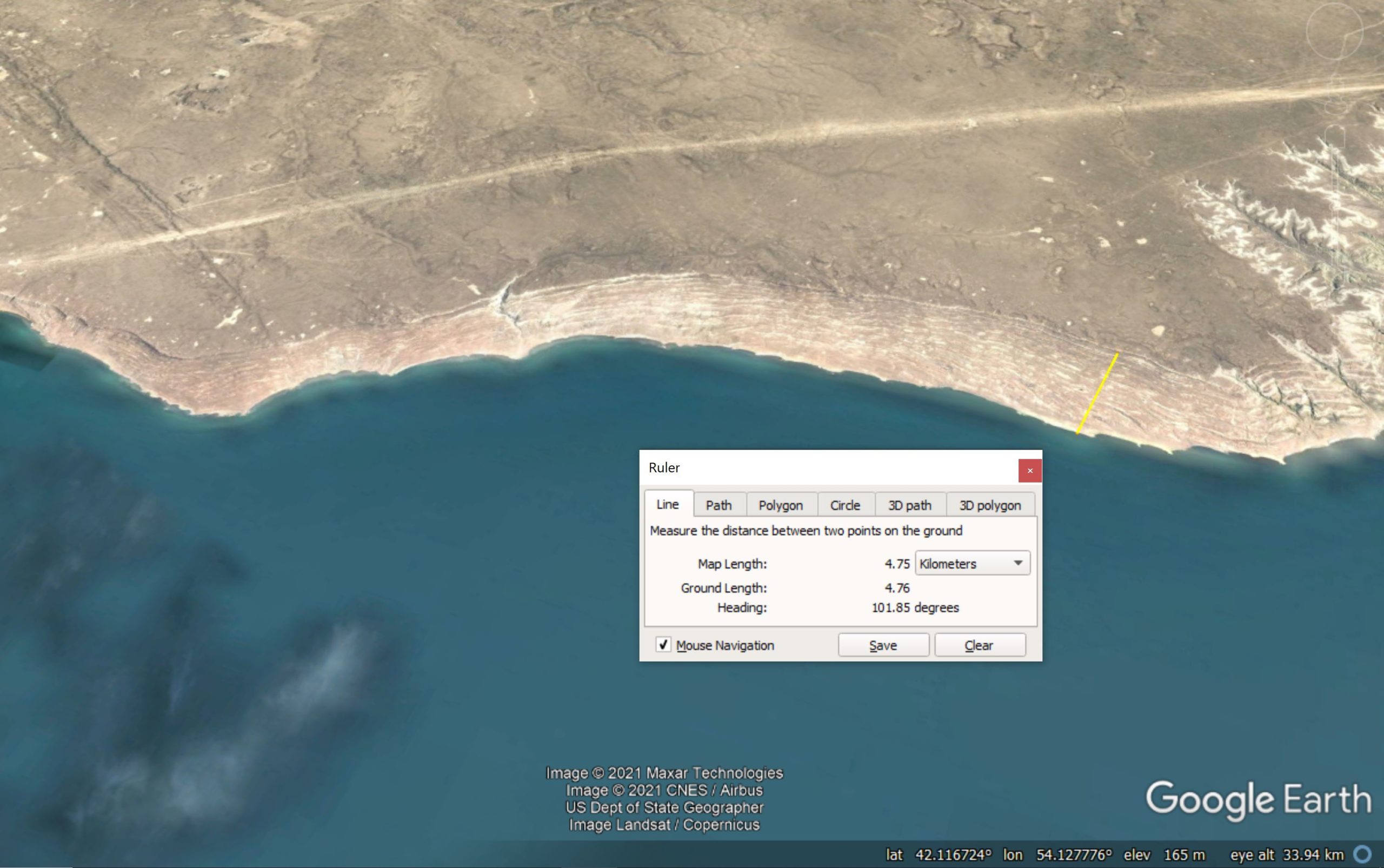
The landslide is located on the banks of the Kara-Bogaz-Gol lagoon in Turkmenistan. The landslide complex can be seen extending along the whole of the bay (and more) in the Google Earth image below, although not all of it is currently active. I have included a Google Earth ruler in the image so that you can appreciate the size of this failure:-
Google Earth image showing the whole of the Kara-Bogaz-Gol Megaslide.
.
The latitude and longitude of the landslide is given on the image above. The scale bar shows that the landslide is up to about 5 km from crown to toe, and the complex extends for over 40 km along the banks of the lagoon. This is a truly enormous landslide.
The Kara-Bogaz-Gol Megaslide is a rotational failure. Aslan et al. (2021) provide the following cross-section to illustrate its form:-
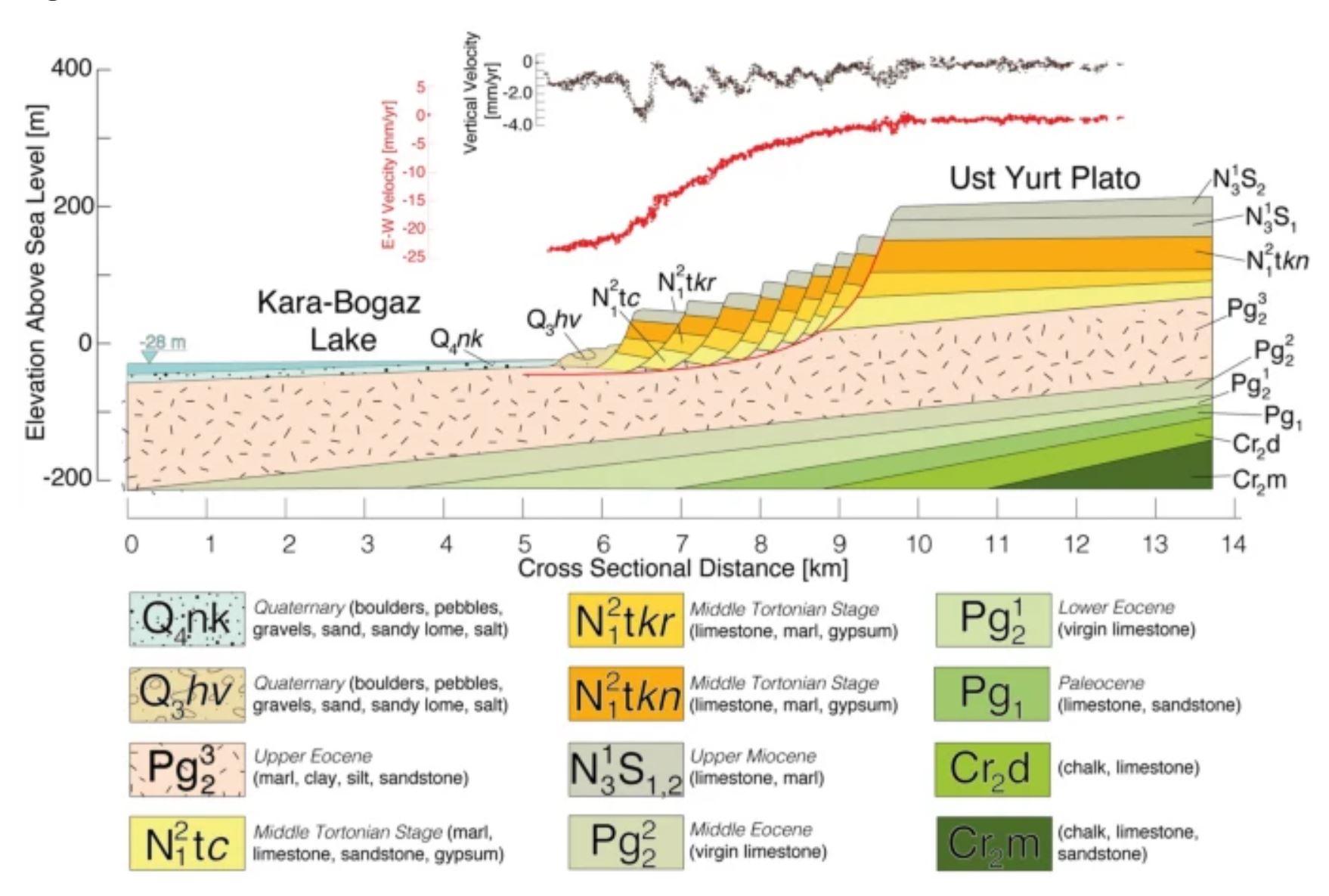
Schematic cross-section through the Kara-Bogaz-Gol megaslide. Diagram from Aslan et al. (2021).
.
As the cross-section shows, the landslide consists of thick blocks of limestones and marls failing of a gently dipping layer of weak Eocene marls, clays, silts and sandstones. At the top of the cross-section are two graphs showing the movement rate. In form this is broadly similar to the Ventnor landslide on the Isle of Wight, but on a much larger scale.
Aslan et al. (2021) have used 354 Sentinel IW SAR that span the period from 2014 to 2020 to extract movement data. They have shown that a mass that extends about 25 km along the lake shore and that extends up to 5 km inland is moving at up to 3 cm per year. This means that the volume of rock that is involved in the active part of the the Kara-Bogaz-Gol megaslide is about 10 cubic kil0metres! The movement rate is not constant, but responds to the level of the lake. Thus, when the lake level is high, and the soil moisture level is also high, more movement occurs.
The authors point out that this area is seismically active I would be fascinated to see how the Kara-Bogaz-Gol megaslide responds to a major earthquake.
.
Reference
Aslan, G., De Michele, M., Raucoules, D. et al. 2021. Transient motion of the largest landslide on earth, modulated by hydrological forces. Scientific Reports 11, 10407 (2021). https://doi.org/10.1038/s41598-021-89899-6
17 May 2021
The 17-18 December 2020 landslide disaster in Presidente Getúlio, southern Brazil
The 17-18 December 2020 landslide disaster in Presidente Getúlio, southern Brazil
Authors: Renato Lima (UFPR – CENACID), Fabiane Acordes (Paraná State Civil Defense – CENACID), Wilson Soares (UFPR, CENACID) and Jefferson Picanço (UNICAMP-CENACID)
On 14 December 2020, significant rains occurred in the municipality of Presidente Getúlio, in the State of Santa Catarina in southern Brazil. According to residents’ reports on the night of 17-18 December 2020, the rains intensified from about 10:30 pm to 11:30 pm, and widespread dangerous geological processes were triggered.
There were 21 deaths in the region across three municipalities: 18 in Presidente Getulio, two in Rio do Sul, and one in Ibirama.
The cumulative rainfall in the last 30 days before the disaster, indicates a total greater than 370 mm in the period, according to data recorded at the Jardim Otilene weather station of the National Center for Monitoring Natural Disasters (CEMADEN), which is located in the centre of the municipality:
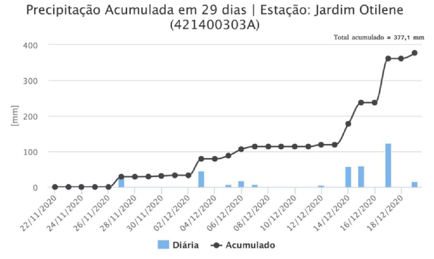
The monthly cumulative rainfall at the Jardim Otilene Station from 21 November to 19 December 2020.
.
In the eight days before the disaster, the total cumulative rainfall recorded at the site was approximately 260 mm:
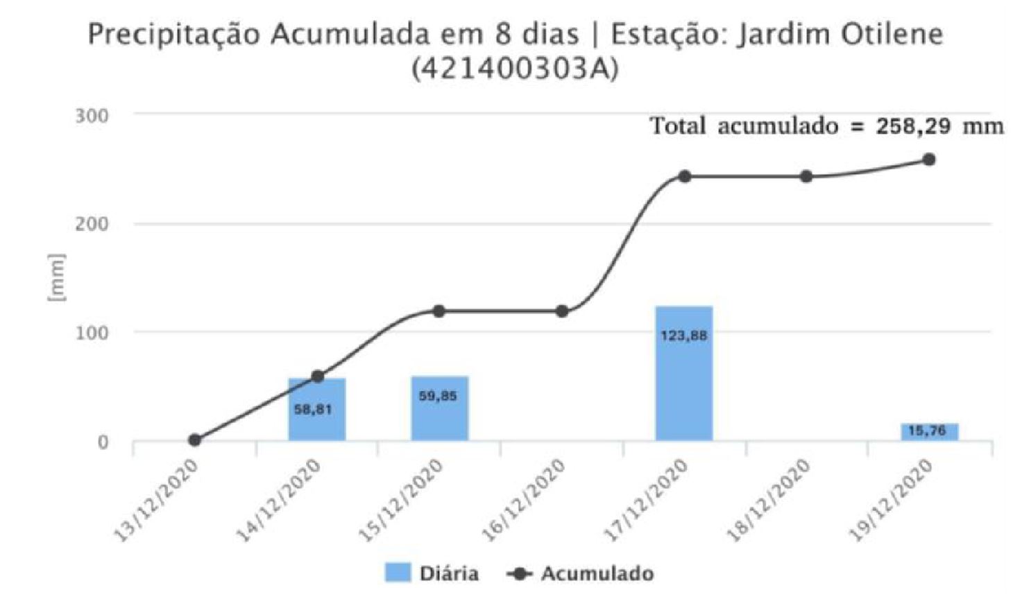
The total cumulative rainfall in Jardim Otilene Station for the period from 13 to 19 December 2020.
.
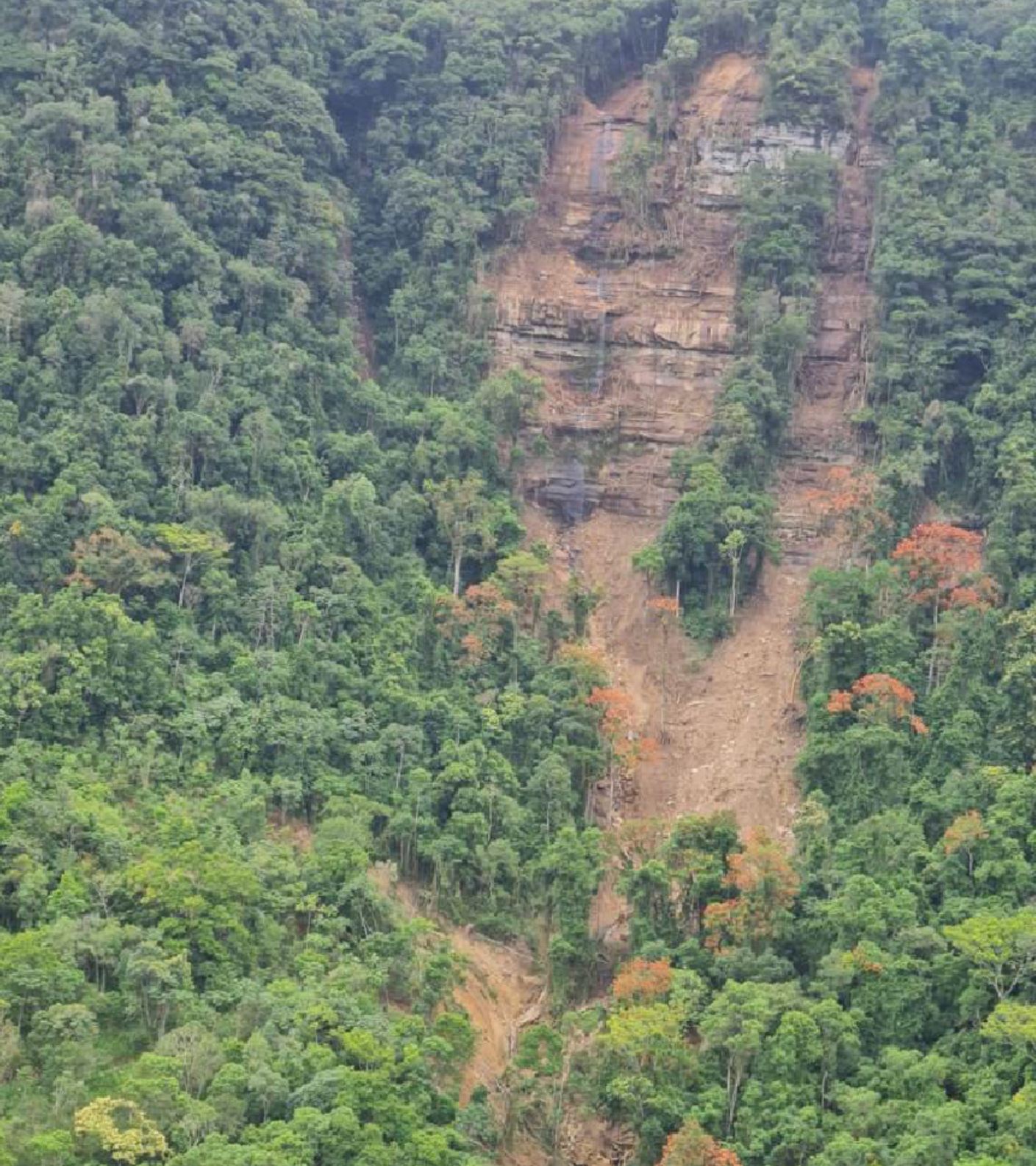
Most of the larger mass movements in the Presidente Getúlio region initiated as translational type landslides in the Palaeozoic sandstone escarpments. The dangerous geological processes identified in this event included landslides, rock falls, debris flow, floods and flash floods, mainly affecting the Revólver Creek valley in Presidente Getulio, and the Cobras Creek valley in the municipality of Rio do Sul. High-energy surface water flows, transporting logs, pebbles, sand, clay and debris, reached the lower portions of the valleys, causing destruction in rural areas and in the urban area of the city of Presidente Getúlio.
Consequently, several roads and bridges were destroyed, houses were damaged or destroyed and agricultural and industrial activities were impacted, achieved by these geological processes of high destructive capacity. The images below show some these events:
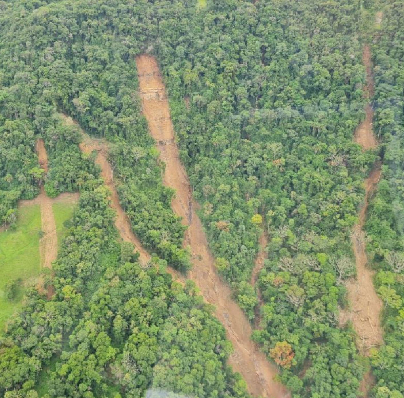
Landslides in the Revólver Creek valley. Photo by Renato Lima.
.
Landslides in the Revólver Creek valley. Photo by Renato Lima.
.
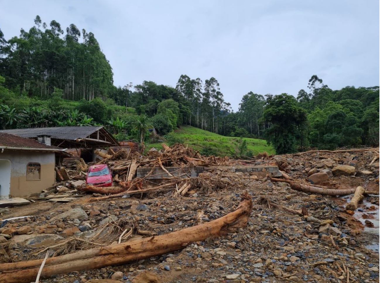
Damage caused by landslides in the Revólver Creek valley in Presidente Getulio. Photo by Renato Lima.
.
Acknowledgement
This report is partly translated from the information in the Mission Report (in Portuguese) of the Center for Scientific Support in Disasters (CENACID) to support the affected community in Presidente Getúlio. CENACID, led by Prof Renato Lima, from the Federal University of Paraná, is an organization that aims “to provide scientific knowledge when it is necessary to reduce the losses and suffering of society in disasters”.
14 May 2021
The LARAM 2021 school
The LARAM 2021 school
LARAM (“LAndslide Risk Assessment and Mitigation”) is an international training programme run by the Geotechnical Engineering Group (GEG) of the University of Salerno. This is a long running training scheme that brings together early career professionals for a two week intense period. The course is taught by eminent landslide scientists. It serves two key purposes:
- It equips cadres of early career researchers with the skills that the need to make a substantial contribution to landslide science;
- It creates international cohorts of researchers, enabling collaboration.
The LARAM organisers describe the school as follows:
For each edition of the school, 40 PhD students are selected to attend the residential courses, selected among applicants working in civil engineering, environmental engineering, engineering geology or related fields. The School can be also attended by some Young Doctors who defended their PhD thesis in the previous 5 years.
The courses include formal lessons, tutorials and field training.
The 2021 version of LARAM will run from 6 to 17 September 2021. Unfortunately, in these pandemic times it is having to run in online format. However, there is no doubt that it will be an exceptionally worthwhile event.
Details of the 2021 programme are now available. Applications are also invited from both PhD students and those recently graduated with a doctoral degree:
- Application for PhD students: https://www.laram.unisa.it/school/2021online/application_phd_students
- Registration PhD graduates: https://www.laram.unisa.it/school/2021online/registration_young_doctors
Whilst the LARAM school was not available when I was early in my career (to my deep regret), many of my post doctoral researchers have attended over the years. They have found it to be an invaluable experience. I thoroughly recommend it.
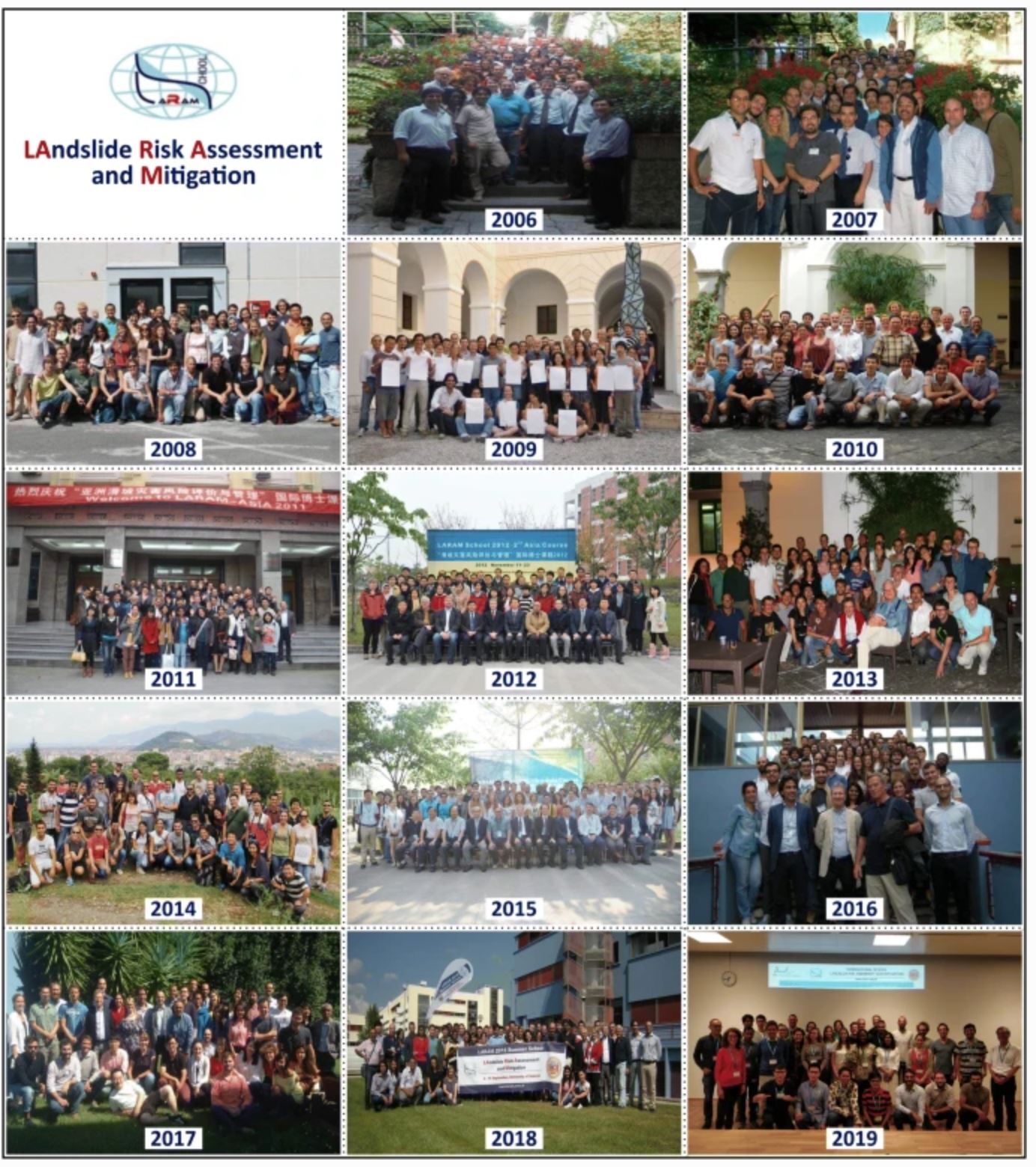
Previous cohorts of students and lecturers on the LARAM programme. Image from Cascini et al. (2020).
.
Reference
Cascini, L., Calvello, M., Cuomo, S. et al. 2020. LARAM School 2020 goes online: the 15th doctoral school on “LAndslide Risk Assessment and Mitigation”. Landslides 17, 1997–1999. https://doi.org/10.1007/s10346-020-01456-w
13 May 2021
Chivay: another valley-blocking landslide in the Arequipa region of Peru
Chivay: another valley-blocking landslide in the Arequipa region of Peru
At 7:30 am on 9 May 2021 a valley-blocking landslide occurred immediately upstream of the town of Chivay in the Arequipa region of Peru. There are news reports about this event on both Prensa National and Inforegion. They report that the landslide is about 300 m long (but see below), blocking the Rio Colca and allowing a lake to form. The Prensa National report has the best image I have found so far:-
The 9 May 2021 valley-blocking landslide at Chivay in Peru. Image from Prensa National.
.
I have marked the location of the Chivay landslide on the Google Earth image below. The location is: -15.627°, -71.598°:-
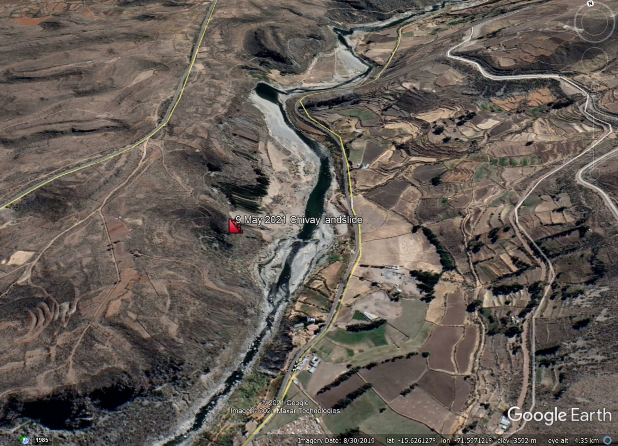
Google Earth image showing the location of the 9 May 2021 valley-blocking landslide at Chivay in Peru.
.
The landslide can be seen on Planet Labs imagery captured in recent days, although unfortunately the resolution does not provide much detail of the failure itself:-
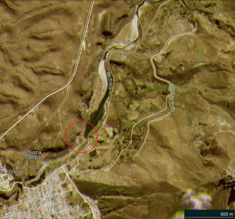
Satellite image showing the location of the 9 May 2021 valley-blocking landslide, and the barrier lake, at Chivay in Peru. Image copyright Planet Labs, captured on 10 May 2021, used with permission.
.
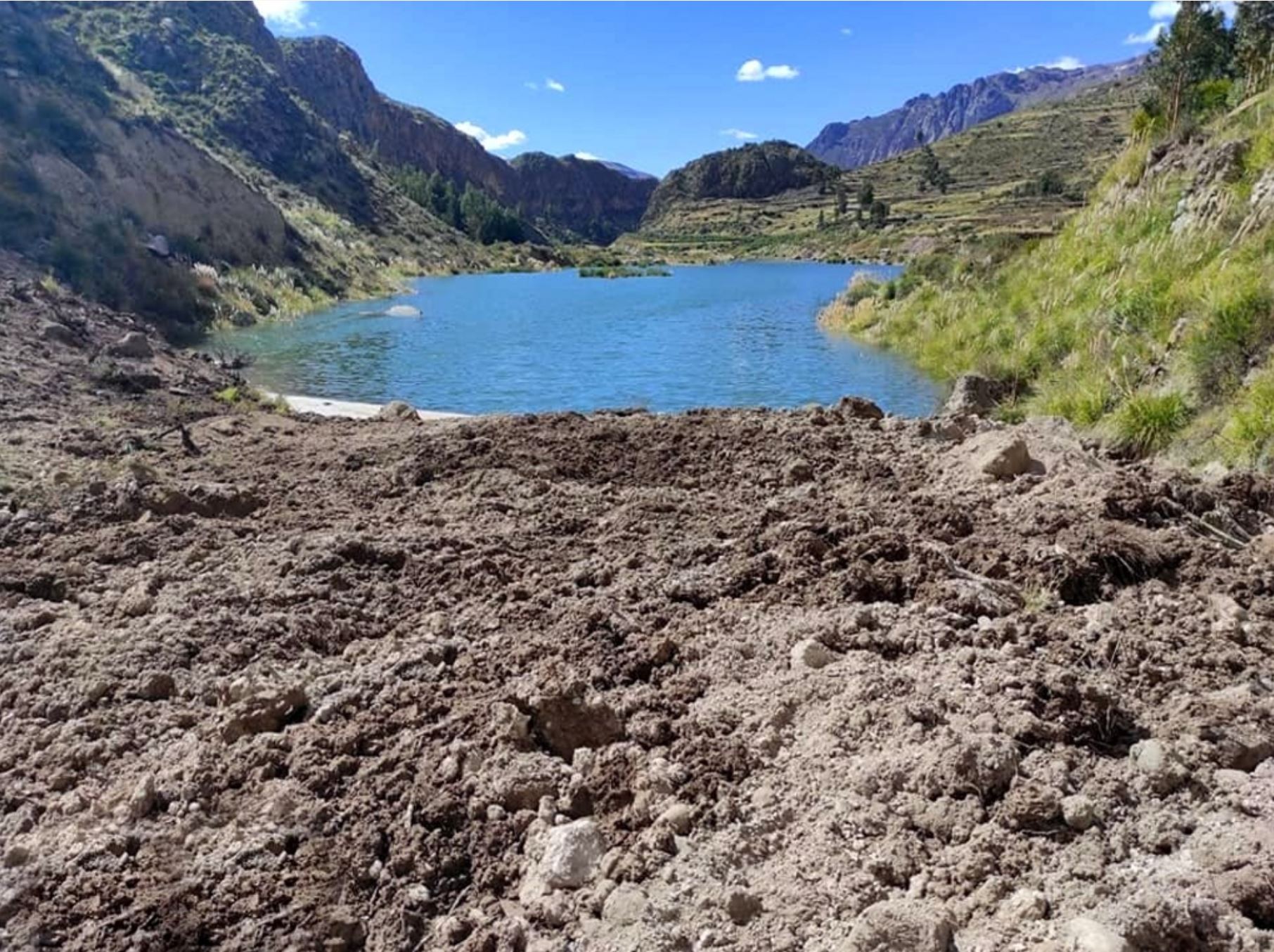
I have highlighted the landslide on the image, but note that it appears to be smaller than the news reports indicate. The barrier lake is clearly visible upstream of the landslide dam. At the time that the image was collected it appears to have been about 1 km long. Images collected yesterday suggest that the barrier had not yet breached.
Whilst the town in immediately downstream of the barrier, the news reports indicate that the risk is not considered to be high at this point. Nonetheless there are plans to construct a channel to allow the lake to drain.
This area was affected by the larger 18 June 2020 Achoma landslide less than a year ago. The landslide dam there was successfully drained.
.
Reference
Planet Team (2021). Planet Application Program Interface: In Space for Life on Earth. San Francisco, CA. https://www.planet.com/
11 May 2021
Historical landslides that have resulted in fatalities in Canada
Historical landslides that have resulted in fatalities in Canada
In Canada, the Pembroke Observer and News has a nice article, published late last week, about historical landslides that have resulted in fatalities in that country. This article is based upon a really good graphic published by the Geological Survey of Canada, which provides detailed information about known fatal landslides between 1771 and 2019. The document (Blais-Stevens 2020) can be downloaded from the Natural Resources Canada website (it is a 46 MB PDF). This is main map from that document:-
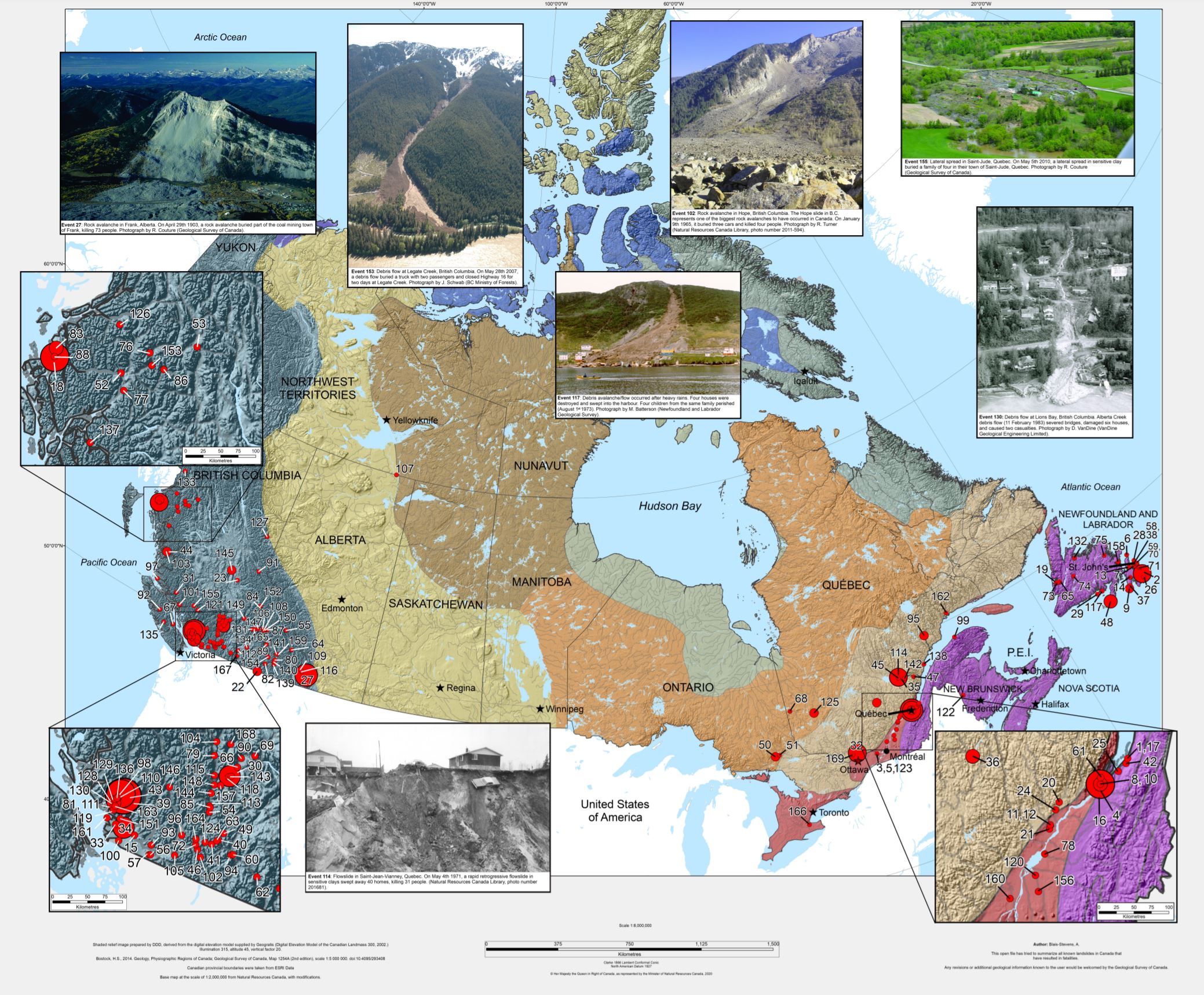
A map showing historical landslides in Canada, from Blais-Stevens (2020).
.
Most of the landslides occur on either the west or the east side of the country. There is a more detailed graphic included in Blais-Stevens (2020) for these two areas:-
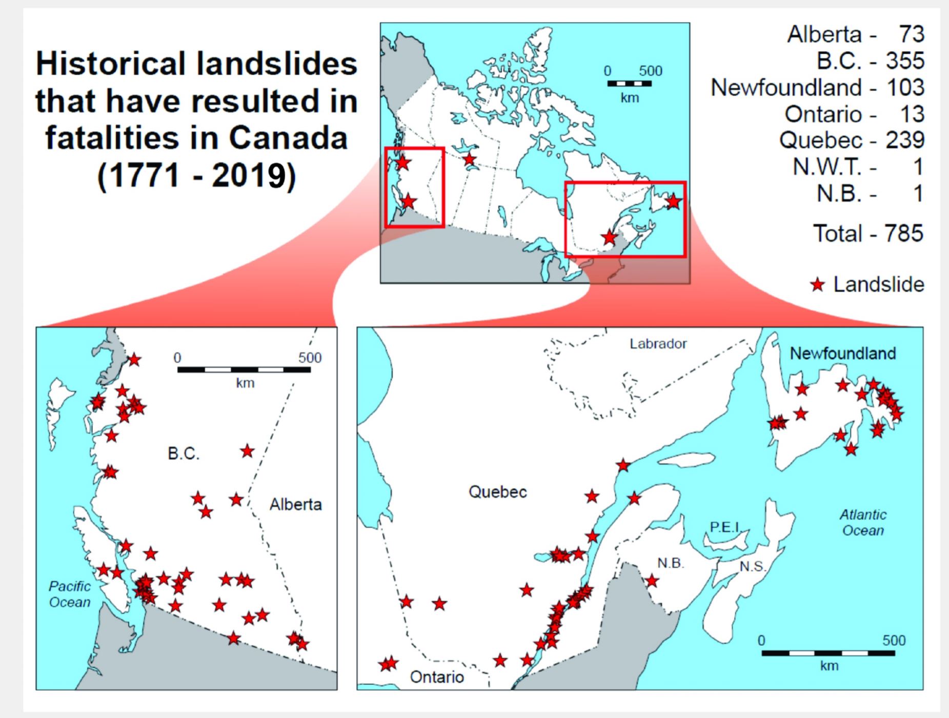
Maps showing historical landslides in Canada, highlighting the hotspots in the east and west of the country, from Blais-Stevens (2020).
.
In total there have been at least 785 fatalities from landslides in the period between 1771 and 2019. The Pembroke Observer and News article makes a couple of very interesting observations about the historical landslides in Canada dataset:
[Natural Resources Canada] said landslides most often happen in rocky, mountainous places, although geological formations such as sensitive clay may also collapse and cause landslides. Unstable soil is the most common cause of landslides in the St. Lawrence Valley – located from Ottawa to Quebec City – and east to the Saguenay region.
And thanks to geological research, fatalities due to landslides in Canada have decreased over the past decades.
Last week was the 50th anniversary of the fatal landslide at Saint-Jean-Vianney in Quebec, in which 32 people were killed. That landslide, which had a volume of 6.9 million cubic metres, was a retrogressive quick clay landslide. I have covered many other major landslides in Canada over the years, including the 2010 Mount Meager landslide and the 2012 Johnsons Landing landslide.
 Dave Petley is the Vice-Chancellor of the University of Hull in the United Kingdom. His blog provides commentary and analysis of landslide events occurring worldwide, including the landslides themselves, latest research, and conferences and meetings.
Recent Comments