10 February 2012
Friday fun: a new landslide video and a remarkable escape from a rockfall
As a bit of light-hearted relief from the Philippines and Papua New Guinea landslides, here are two interesting landslide items.
First, with a hat-tip to Greg Springer, there is a new landslide video on Youtube. It is another good one (despite the music):
http://www.youtube.com/watch?v=5Px-73K_4SU
According to the Youtube page “The landslide occurred summer 2011 in Athens County, Ohio during construction of a new road.”
I will update the ultimate landslide video page in the next few days to include a much larger selection of events.
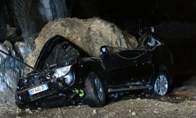
Second, thanks to Zetica’s twitter feed (@zeticaltd), Metro has the story of a remarkable escape from a car crushed by a boulder (ie. a rockfall) in France:
The report states that the victim is expected to make a full recovery.
Comparing the response to the Tumbi Quarry and Philippines earthquake landslides
One of the remarkable facts about the Tumbi Quarry landslide in Papua New Guinea is that there still appears to be considerable doubt about the numbers of people lost. Reports still vaguely mention an estimated number of 25 people, and possibly as many as 60. Even the unimpressive National Disaster Centre report said only: “At this stage, there is no exact figure of the population affected; No bodies have been recovered.” Given that there is very little likelihood of being able to recover the bodies from such a vast landslide, it is surprising that there are no reports of detailed work to ascertain who has been killed. One can only hope that this is happening in the background.
In remarkable contrast, remarkably good data is available from the Philippines, despite the obvious chaos of the earthquake impacts. The latest NDRRMC report gives lots of information about the impacts of the earthquake. Most impressive is the care that has gone into compiling victim statistics. This data shows that of 34 confirmed fatalities, 20 occurred as a result of landslides. There are 71 people reported to be missing, all thought to be buried under landslides. If these statistics are a true reflection of losses, it will mean that of 105 fatalities, 91 will have been caused by landslides.
Seismologists often say that it is not earthquakes that kill people, it is buildings. Yet again that has been shown not to be correct, but investment in understanding and mitigating earthquake induced landslides remains pitiful.
Some pictures are now emerging of the landslides. International Business Times has this one of the landslide in La Libertad:
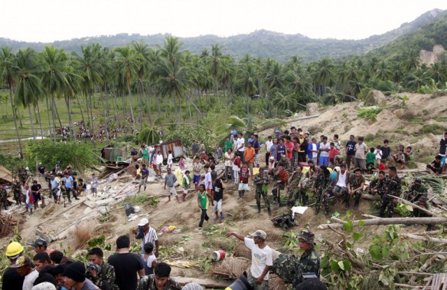
http://www.ibtimes.com/articles/294314/20120207/philippines-earthquake-death-toll-rises-sends-condolence.htm
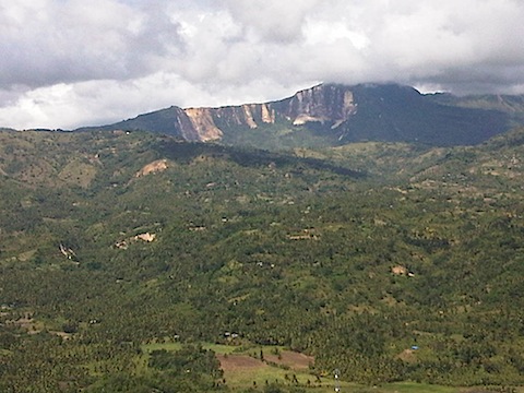
Quezon.ph has this rather helpful image of landslides on La Libertad mountain. Note that most of the landslides seem to have initiated at the ridge top, which is a characteristic sign of earthquake induced landslides:
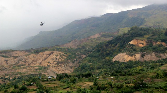
Even more remarkable is this helicopter image of the landslide at Guihulngan, from CTV:
9 February 2012
Comparing initial landslide reports: Tumbi Quarry, Papua New Guinea and Kaikora, New Zealand
Several people have asked what I mean by a proper landslide investigation with respect to the report on the Tumbi Quarry landslide. To illustrate, one might compare these two reports:
1. The Tumbi Quarry landslide report, prepared by the National Disaster Center.
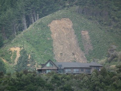
2. Report on the landslide that blocked SH 1 and the railway line near Rosy Morn Stream south of Kaikoura on 10 September 2010, prepared by GNS Science as part of the Geonet programme.
The GNS report is not long, and nor is it highly detailed. However, it is throrough, it investiogates and describes the landslide properly, and it allows evidence-based conclusions to be drawn about he landslide and its triggers and causes.
This should be the minimum level of report for a major landslide event. Of course, in New Zealand (or indeed the UK) a landslide that killed 25 or more people would probably be investigated in very much more detail.
7 February 2012
An official report on the Tumbi Quarry landslide
The National Disaster Council of Papua New Guinea has posted online a report into the Tumbi Quarry landslide (see previous posts here, here, and here). Presumably this is the “official investigation” that was promised. They should be credited with making this available online, and the document has some useful information on, and images of, the landslide. It is also helpful to get the official view on the landslide event, and there is a management plan for the victims and survivors of the accident.
However, there are aspects of the report that are perhaps interesting, as follows:
1. The report only very briefly mentions the quarry. The report states that “naturally high geological weaknesses assisted by abnormally high rain fall combined to cause subsidence to the immediate north west of the quarry triggering a landslide of composite debris.” The image on the front cover clearly shows a part of the quarry, with some of the benches truncated by the lateral margin of the landslide:
The report is ambiguous as to whether this means that the landslide was associated with the quarry. It maybe that the quarry access / haul road also crossed the area now destroyed by the landslide (as per the Esso Highlands plan), and yet this is also not discussed. Clearly at least a part of the quarry was lost in the landslide, so a proper discussion of whether the quarry played a role in activating these weaknesses seems essential to me.
Note also that these naturally-occurring geological weaknesses are not described or discussed (I assume that this means a set of joints?), and the mechanism of “subsidence” is also quite strange.
2. The landslide trigger is definitively described as being rainfall, on the basis that there was no recorded seismicity. However, although “continuous heavy rainfall” is described, there is no data to support this, and no eye-witness reports. The next sentence talks about “abnormally high rainfall”, but I can find no other reference to this event. I wonder what evidence there is for this abnormal rainfall event, given the high rainfall that this area is likely to receive anyway.
3. There are odd aspects of the landslide mechanism as described in the report. First, the report notes that pools and seepage on the shear face indicate that the “ground water rose significantly above its historical levels”. I do not understand this logic. Seepage and pools are likely to occur in the aftermath of almost any deep landslide of this type, and I do not see why they indicate that the groundwater levels were abnormally high, or indeed that groundwater even played a substantial role. Second, the report notes that the initial assessment team “saw clear evidence of liquefaction of the rock formation”. This is most surprising. Limestone is not a material that undergoes liquefaction – I have never heard of such a mechanism in any hard (as defined from an engineering behaviour perspective) rock – and so I just cannot understand this purported process. Unfortunately, it is not discussed further.
So overall, whilst the description of the site is really helpful, though it would be good to see a more detailed consideration of the ways in which the quarry might have been a factor in activating these geological weaknesses. In designing a quarry it is normal practice to ensure that such natural weaknesses are not exposed to the point that they can permit slope failure to occur.
To my mind this report should not be considered to be the definitive analysis of this landslide. Much more detailed analysis is needed, and lessons need to be learnt in terms of other slopes in Papua New Guinea.
An update on the landslides from the Philippines Earthquake
The earthquake in the Philippines yesterday appears to have stirred barely a ripple in the global media, but in a comparatively small area of Negros Oriental conditions are clearly very difficult. It is now clear that the majority of deaths have resulted from landslides. The latest NRRDMC report lists one confirmed fatality from a landslide in Tayasan, plus 29 people missing at Barangay (village) Planas in Guihulngan, and 42 missing at Barangay Solonggon in La Libertad, giving a landslide toll to date of 72 people.
Meanwhile the media is also reporting that the landslide at Planas appears to have blocked the river:
“A new crisis unraveled when the landslide in Planas clogged a mountain river, threatening about four villages downstream. If the river swells or the landslide gives way, the accumulated water may sweep away houses along the banks, Reyes said. Residents were warned to move away.”
6 February 2012
First news of landslides from the earthquake in the Philippines this morning
The Negros Oriental area of the Philippines suffered a M=6.7 earthquake this morning at 11:49 am local time. Although moderately deep (20 km ), this event appears to have caused some damage, with news reports suggesting that at least 52 people have been killed. The timing of the earthquake just a few hours before sunset probably means that the full picture won’t be available until the morning, but it is possible that the losses will rise. Interestingly, losses are more than the PAGER data would indicate.
Interestingly, at the moment it appears that a substantial number of these losses may be associated with landslides. For example, inquirer.net is reporting at several landslides. These seem to include:
- 29 people killed in a landslide in a landslide in Barangay Planas in Guihulngan City;
- 10 people killed in a landslide on Ten others died due to a landslide on the Guihulngan national road
- An unknown number of people trapped in the village of Solongon in La Libertad
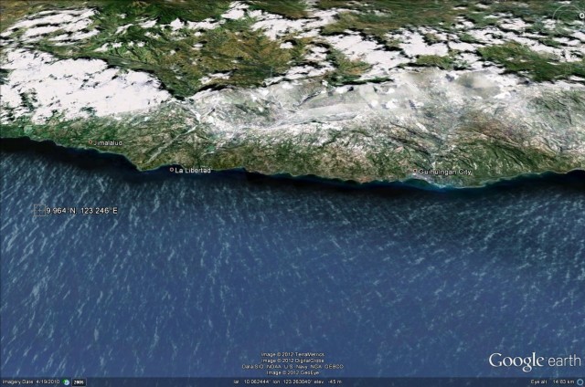
A quick look at the Google Earth image of the affected area hints at why the landslide losses may be high:
The coastal strip affected the earthquake (note the epicentre location in the sea on the left side) is both steep and inhabited.
The NDRRMC is posting updates here. This is likely to be the best source of information on losses by this time tomorrow.
1 February 2012
Investigating the Tumbi Quarry landslide in Papua New Guinea
Despite widespread calls for an investigation of the Tumbi Quarry landslide in Papua New Guinea, and a pledge from the PNG Government to undertake such an inquiry, there is little evidence of action. Given the suggestions, at the moment with no hard evidence either way in the public domain, that quarrying operations for the Exxon-Mobil LNG pipeline project may have played a part in the initiation of the landslide, this is somewhat unfortunate. RNZI has today posted an article from which this quote is taken:
“Christine Yango denies that the project is to blame for the landslide, saying it was a natural phenomenon which has nothing to do with nearby LNG activity”
Christine Yango is the Liaison Officer with Oil Search, one of the partners in the LNG Project. If this quote is true then it appears that the company has already come to a conclusion about the landslide. I wonder as to the basis for this.
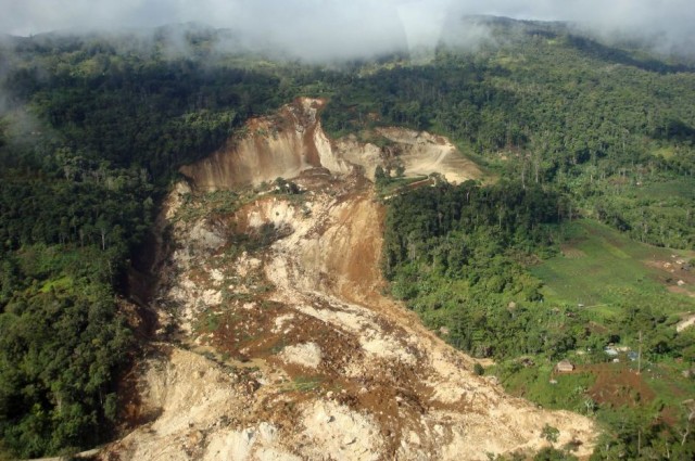
So lets just summarise what we know about the landslide. First, the landslide is located at, and indeed has destroyed, the Tumbi Quarry site. This is clearly evident from the first image that I posted:
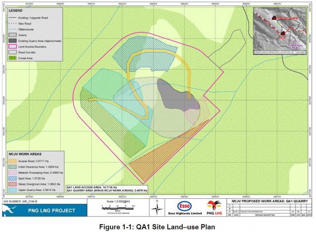
The remains of what I infer to be the quarry roads and cuts are located in the upper right part of the image, although most of the works appear to have been destroyed. It is interesting to note that there is no real sign of the spoil (e.g. topsoil) from the quarry works – I wonder where the dump sites for this were located (this is peculiar given the indicative locations in tha map below)? If downslope or upslope of the main quarry area then this may have been a factor in the development of instability.
Second, the LNG project documentation clearly states that a quarry at this site was to be used in the LNG Project for aggregate extraction. On page 6 it states that “Tumbi Quarry, known as QA1, is required for aggregate to be used by the Project in the Komo area”. The document even provides a map of the proposed quarry (see page 10 of the pdf):
To gain an understanding of the orientation, the photograph above has been taken from the northeast looking southwest onto the site.
This indicates that the quarry site was located right in the middle of the section of slope that has failed. It is bold to suggest that the two are not linked without undertaking a proper investigation.
Finally, if this is a natural slope failure, I wonder what was the cause? The images do not suggest that heavy rainfall was occurring at the time, and I have seen no indications of earthquake activity. It is true that progressive failure sometimes means that a slope fails without a trigger, but if so then the site would have shown extensive evidence of deformation – e.g. cracks, grabens, lateral scarps, etc. If the ground showed such features then these would normally be picked up in the ground investigation prior to the extension of the quarry, and during routine monitoring as the quarry was developed. If such features were present, the quarry is unlikely to have been developed – the risk of failure would have been too high. And if they were picked up in routine monitoring, action would have been taken immediately as slope failures are a major threat to quarry operations.
So there is a real contradiction here that needs addressing:
- If this was a natural (i.e. progressive) failure, as the liaison officer suggests, then why weren’t the surface features of the landslide picked up prior to the construction of the quarry, and indeed during quarrying operations?
- But, if these indications of failure were not present, then the slope failure was most likely triggered by a short term process – which would normally be one of intense rainfall, seismicity or human activities. Which of those was occurring at the time of the landslide to trigger it?
Maybe there is a simple explanation for this contradiction, but at the moment I am unsure as to what this might be. Of course an independent investigation would find this. Personally, I would have thought that it would be in the interests of Exxon-Mobil to undertake such an investigation in order to clear up the uncertainty regarding the role of the quarry in the initiation of this landslide.
Meanwhile, judging by the media reports a major concern of the pipeline developers appears to be the logistical challenges associated with the loss of the road. Again, quoting the RNZI article, Christine Yango is quoted as syaing:
“Yeah I think people are waiting. But we can’t deny the fact that the road system is cut off because of the landslide. It affects major infrastructure areas: the Hides gas conditioning plant and the Komo airfield; the road that brings all the supplies and things. I think at the moment that for food rations and things like that, they’re using air transport, helicopters, but they haven’t cleared up the area to allow vehicles to pass through yet.”
31 January 2012
An update on the Tumbi Quarry (Papua New Guinea) landslide
The landslide a week ago in Papua New Guinea continues to generate a great deal of noise in that part of the world. The confirmed death toll is now 25 people, but that number is expected to rise. However, given the size of the landslide, I wonder whether it is really possible to recover all of the victims. Only four bodies have been recovered to date.
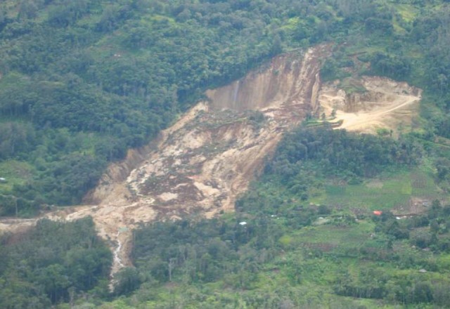
There are now some better images of the landslide available online. This one, from the Australian, appears to show the head-scarp area:
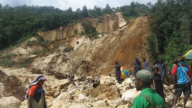
http://www.theaustralian.com.au/news/world/fears-for-life-as-landslide-hits-png/story-e6frg6so-1226253126412
The article suggests that the landslide occurred at the site of a limestone quarry (of which more below). Certainly the rock would appear to be limestone with quite a thick soil layer. The very planar rear scarp would suggest a large, unfavourable joint as the release plane. The block at the top on the left is still sitting on this joint and may be unstable. The joint either has a very weathered surface and/or is draped by soil from above.
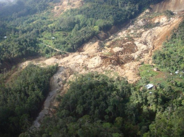
There is also a good overview photograph from the Namorong Report website:
It is interesting to see the way in which the lower part of the landslide has bifurcated down two drainage paths – unusual but not at all unprecedented. Of more interest is the apparently large lateral margin scarp on the far side of the landslide, below the trees, which suggests that the landslide has removed a considerable volume of material on that side. It is hard to tell, but this does not seem to be replicated on the nearside. To me this suggests quite a complex landslide process (although this does not mean that the triggering process itself was complex). This does suggest that if a meaningful investigation of this landslide is to be undertaken then it will need someone who really knows how to interpret landslide processes. It is not likely to be straightforward in any way.
At the time of the landslide there were suggestions that it was linked to the LNG pipeline being built through the area by ExxonMobil. It now appears that the hillslope was a limestone quarry associated with the project, which fits with my observations of the area at the crown of the landslide. There is a pdf online here,with an Esso Highlands logo, entited “TUMBI QUARRY (QA1) Resettlement Action Plan”, which states that “Tumbi Quarry, known as QA1, is required for aggregate to be used by the Project in the Komo area. The Project will be leasing the quarry from Hides Gas Development Corporation (HGDC) for an estimated two year period, depending on aggregate requirements of the Project, after which the quarry will be returned to HGDC.”
The LNG watch blog has a post by Dr Kristian Laslett of Ulster University, which notes that the site had been blasted in the days leading up to the landslide. This seems to be supported by various news reports, although of course there is no proof either way. It seems entirely plausible, though not certain, that the landslide could have been triggered by blasting. There are many previous examples of landslides being triggered by quarries.
It seems to me that an investigation of this event is urgently required. However, the investigation does need to be undertaken by an open-minded, independent and very experienced team as the landslide is complex. IF the quarry was the cause or trigger for the landslide, and if it was providing rock for the Exxon-Mobil project, then this is surely somewhat significant.
Given the focus on the Deepwater Horizon accident a couple of years ago, I am amazed that the mainstream media are not pursuing this story with some alacrity. One would also hope that Exxon-Mobil will fund a proper investigation of this, and that they will look again at any other quarries that are providing rock for the pipeline project.
24 January 2012
Breaking (with pictures) – very large landslide in Papua New Guinea
At 6 am local time this morning (Tuesday) a very large landslide occurred in the Hides and Komo area of Papua New Guinea. This area is currently the focus of an ExxonMobil project to build a LNG pipeline, although at the moment is really unclear as to whether the landslide is linked to this work. However, there are news reports that local people may have been buried, with suggestions that there may be as many as 40 people missing. It appears that all those involved in the pipeline project are safe.
Surprisingly for such a recent event, ABC News has two very high quality images of the landslide. The first of these seems to show the source area:
A couple of things to note. First,, obviously, this is really big. Second, looking at the area to the right side of the head scarp it appears that there has been some slope cutting in this area – indeed there may be a couple of tracks and suchlike. I wonder why? These tracks have been cut off by the margin of the slide, suggesting that the pre-failure morphology had been modified. Second, towards the bottom of the image a road has been buried to a substantial depth.
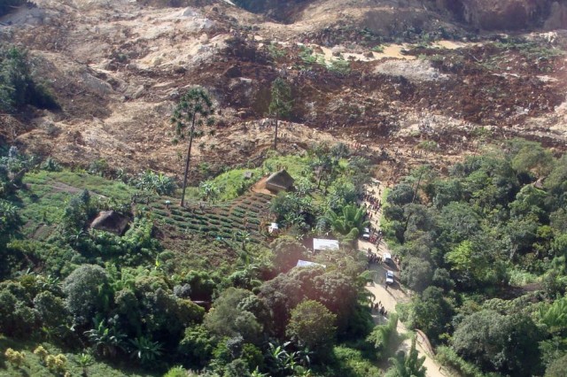
The other image captures the downslope impact of the event:
The proximity of the houses suggests that there could well have been loss of inhabited areas. Note the water flowing at the top of the image.
Unfortunately the images neither support nor refute suggestions that the pipeline works might have played a part in this. I am sure that more information will become available in the next few hours. The apparently dry conditions at the time of failure are quite perplexing.
21 January 2012
The ultimate compilation of the best landslide videos
For a while I have been meaning to put together a compilation of the best landslide videos available on the internet. There is now a large number of these, so this will be a medium term project. However, I thought I’d post the first set, and then add to it through time.
Needless to say, I welcome suggestions for videos that I have missed.
1. Drawdown landslides at the Condit Dam
2. Rockfall at the Franz Joseph Glacier
3. Cliff collapse in Cornwall
See blog post here and update here
4. A pick-up truck being struck in Taiwan
5. Landslide in Uttarakhand, India
http://www.youtube.com/watch?v=oKID3LSOYrk
6. Landslide in Garwhal, India
7. Riverbank failure on the Mohawk River, USA
8. Intentionally-triggered rockfalls in Christchurch
http://www.youtube.com/watch?v=h_tZjT850qI
9. Reconstructing the Po Shan landslide in Hong Kong
10. Landslide at Merano in Italy
11. Pulsing debris flow in Pakistan
12. A landslide impacts a road in South Korea
13. Amateur footage of landslides in South Korea
14. A debris flow in Northern Italy
15. Two views of the Dalhousie landslide in India
16. A lucky escape for an excavator driver in New Zealand
I can’t embed this one – see the video here
17. A retrogressive landslide in Russia
Skip forward to the 5 minute 15 second point in the video:
18. Debris avalanche / Lahar on Mount Rainier
19. Two riverbank collapse videos


 Dave Petley is the Vice-Chancellor of the University of Hull in the United Kingdom. His blog provides commentary and analysis of landslide events occurring worldwide, including the landslides themselves, latest research, and conferences and meetings.
Recent Comments