1 February 2012
Investigating the Tumbi Quarry landslide in Papua New Guinea
Posted by Dave Petley
Despite widespread calls for an investigation of the Tumbi Quarry landslide in Papua New Guinea, and a pledge from the PNG Government to undertake such an inquiry, there is little evidence of action. Given the suggestions, at the moment with no hard evidence either way in the public domain, that quarrying operations for the Exxon-Mobil LNG pipeline project may have played a part in the initiation of the landslide, this is somewhat unfortunate. RNZI has today posted an article from which this quote is taken:
“Christine Yango denies that the project is to blame for the landslide, saying it was a natural phenomenon which has nothing to do with nearby LNG activity”
Christine Yango is the Liaison Officer with Oil Search, one of the partners in the LNG Project. If this quote is true then it appears that the company has already come to a conclusion about the landslide. I wonder as to the basis for this.
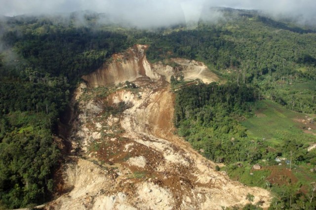
So lets just summarise what we know about the landslide. First, the landslide is located at, and indeed has destroyed, the Tumbi Quarry site. This is clearly evident from the first image that I posted:
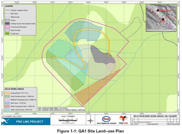
The remains of what I infer to be the quarry roads and cuts are located in the upper right part of the image, although most of the works appear to have been destroyed. It is interesting to note that there is no real sign of the spoil (e.g. topsoil) from the quarry works – I wonder where the dump sites for this were located (this is peculiar given the indicative locations in tha map below)? If downslope or upslope of the main quarry area then this may have been a factor in the development of instability.
Second, the LNG project documentation clearly states that a quarry at this site was to be used in the LNG Project for aggregate extraction. On page 6 it states that “Tumbi Quarry, known as QA1, is required for aggregate to be used by the Project in the Komo area”. The document even provides a map of the proposed quarry (see page 10 of the pdf):
To gain an understanding of the orientation, the photograph above has been taken from the northeast looking southwest onto the site.
This indicates that the quarry site was located right in the middle of the section of slope that has failed. It is bold to suggest that the two are not linked without undertaking a proper investigation.
Finally, if this is a natural slope failure, I wonder what was the cause? The images do not suggest that heavy rainfall was occurring at the time, and I have seen no indications of earthquake activity. It is true that progressive failure sometimes means that a slope fails without a trigger, but if so then the site would have shown extensive evidence of deformation – e.g. cracks, grabens, lateral scarps, etc. If the ground showed such features then these would normally be picked up in the ground investigation prior to the extension of the quarry, and during routine monitoring as the quarry was developed. If such features were present, the quarry is unlikely to have been developed – the risk of failure would have been too high. And if they were picked up in routine monitoring, action would have been taken immediately as slope failures are a major threat to quarry operations.
So there is a real contradiction here that needs addressing:
- If this was a natural (i.e. progressive) failure, as the liaison officer suggests, then why weren’t the surface features of the landslide picked up prior to the construction of the quarry, and indeed during quarrying operations?
- But, if these indications of failure were not present, then the slope failure was most likely triggered by a short term process – which would normally be one of intense rainfall, seismicity or human activities. Which of those was occurring at the time of the landslide to trigger it?
Maybe there is a simple explanation for this contradiction, but at the moment I am unsure as to what this might be. Of course an independent investigation would find this. Personally, I would have thought that it would be in the interests of Exxon-Mobil to undertake such an investigation in order to clear up the uncertainty regarding the role of the quarry in the initiation of this landslide.
Meanwhile, judging by the media reports a major concern of the pipeline developers appears to be the logistical challenges associated with the loss of the road. Again, quoting the RNZI article, Christine Yango is quoted as syaing:
“Yeah I think people are waiting. But we can’t deny the fact that the road system is cut off because of the landslide. It affects major infrastructure areas: the Hides gas conditioning plant and the Komo airfield; the road that brings all the supplies and things. I think at the moment that for food rations and things like that, they’re using air transport, helicopters, but they haven’t cleared up the area to allow vehicles to pass through yet.”


 Dave Petley is the Vice-Chancellor of the University of Hull in the United Kingdom. His blog provides commentary and analysis of landslide events occurring worldwide, including the landslides themselves, latest research, and conferences and meetings.
This is only vaguely related to landslides but I think you might be interested anyway because it involves a rather large amount of earth moving. It happened somewhere in China apparently. Probably creating an earthfill dam for a hydropower project…
http://www.liveleak.com/view?i=c66_1328115732 Blowing up a mountain – HD quality
Fullscreen recommended! It would be nice to see the aftermath of this blast. (Unfortunately the LL posting doesn’t offer any links or other explanation.)
[…] has posted online a report into the Tumbi Quarry landslide (see previous posts here, here, and here). Presumably this is the “official investigation” that was promised. They should be […]