
16 January 2014
Aoraki / Mount Cook: A new survey of its height after the 1991 landslide
The 1991 Aoraki / Mount Cook rock avalanche
On 14th December 1991 a rock avalanche occurred on Aoraki / Mount Cook in New Zealand, travelling a total distance of 7.5 km. The slide, which had an estimated volume of 12 million cubic metres, removed the top of the mountain, although forunately it did not cause any loss of life or property. GNS have a short information page about the landslide, which includes this (famous in the landslide-world!) image:
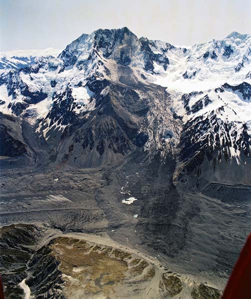
http://www.teara.govt.nz/en/photograph/8785/aorakimt-cook-landslide
..
The landslide was believed to have removed about 10 m from the summit of the mountain, leaving a knife-edge ridge as shown in the image below, taken by Mauri McSaveney, also of GNS. The circled dot is a climber for scale:
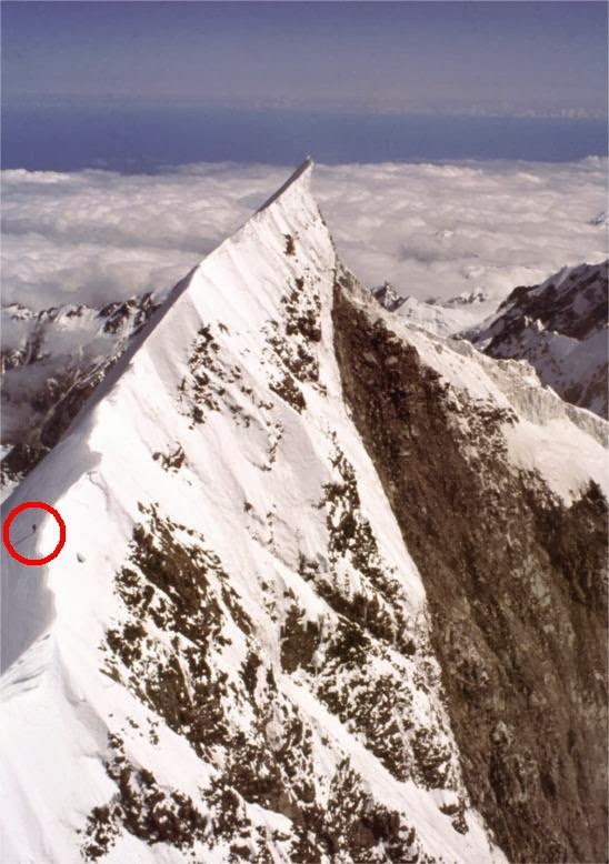
http://juliansrockandiceblog.blogspot.co.nz/2014/01/the-changing-height-of-mount-cook.html
..
The 2013 resurvey of the height of Aoraki / Mount Cook
It was inevitable that such a knife-edge ridge would undergo erosion, reducing the height of the mountain further. However, until now no proper survey had been undertaken of the height of the mountain. GNS, working with the University of Otago, have just completed an expedition to accurately record the height of Aoraki / Mount Cook 22 years after the event. This is described in a very nice post on Julian’s Blog, and there is a Youtube video of the work as well:
..
..
The conclusion of the research is that the height of Aoraki / Mount Cook is now 3724 metres above mean sea level, meaning that the mountain is now 30 m lower than before the rock avalanche.
If you are interested in the science behind the work, it is well described on a University of Otago project web page.
13 January 2014
The Dart Valley landslide in New Zealand
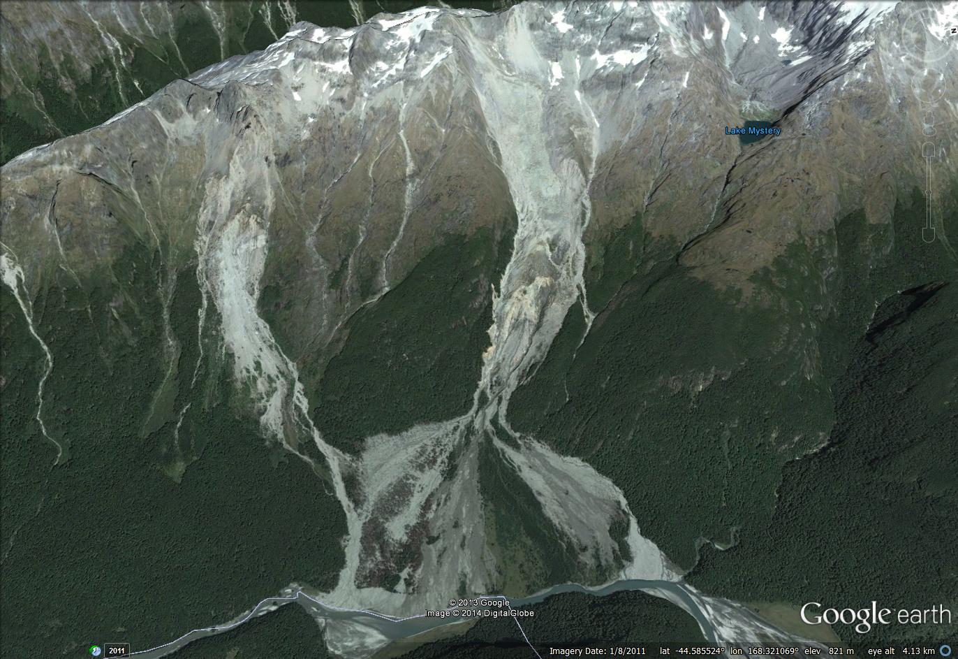
Dart Valley Landslide
In the last two weeks there has been some interest in New Zealand in a landslide that blocked the Dart Valley on South Island on 4th January, creating a large lake. Initially there was some concern that this landslide dam might suffer a breach event, but fortunately the water overtopped the landslide deposit without a major failure. The landslide is a well-known feature (GNS have a long-standing image of it on their website), situated in the Te Koroka / slip stream area, and located at -44.587,168.332. It is easily identifiable on Google Earth from an image in August 2011:
..
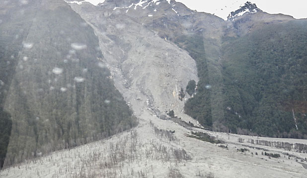
The January 2014 movement event is just the most recent of a succession of landslides at this site – it has even been written up in a GNS Science report (Thomas and Cox 2009), although sadly I cannot find this online. Several news stories have good images of the landslide during this recent event, including this one from The Press:
http://www.stuff.co.nz/the-press/news/9581270/Landslide-blocks-Dart-River
..
The lake that developed reached a maximum length of over 3 km and is over 20 m deep. Aerial imagery suggests that this is quite an impressive feature:
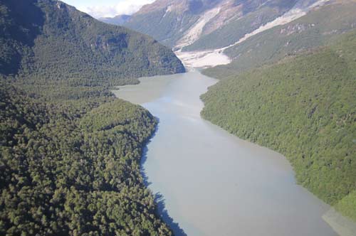
http://www.scene.co.nz/new-track-around-dart-valley-lake–/314404a1.page
..
The major impacts of the landslide has been the inundation of a hiking track along the valley, which has now been rerouted, and temporary suspension of jet-boating downstream. The landslide dam is not considered to pose a major risk. However, the silt generated by the erosion of the landslide has also caused the colour of the water in Lake Wakatipu to change to a blue-green colour.
Finally, there is a lovely gallery of images of the landslide and the valley below from two years ago located here, and another one can be found here.
Reference
Thomas, J.S. and Cox, S,C. 2009. 42 years Evolution of Slip Stream Landslide and Fan, Dart River, New Zealand. GNS Science Report Sr 09/43, 32 pp.
10 January 2014
Abaetetuba landslide: more information and photographs
The Abaetetuba landslide was indeed a landslide
More information has emerged about the Abaetetuba landslide. Yesterday I speculated that the video of the “sinkhole” at “Abadetetub” was in fact a riverbank collapse event at Abaetetuba; I’m pleased to say that this is the case. Thanks to everyone who sent information in comments and by Twitter. Raphael Rocha pointed me to an article (in Portuguese) on the G1 website, which provides some detail about the site of the Abaetetuba landslide. In particular, it seems to suggest that the houses were built on fill material that includes “debris, trash, broken tiles, clay, organic matter”. In total, 13 houses were destroyed, 78 families were affected and 106 people were left homeless.
Images of the landslide aftermath
A number of images of the site are now available. This is probably the most useful:
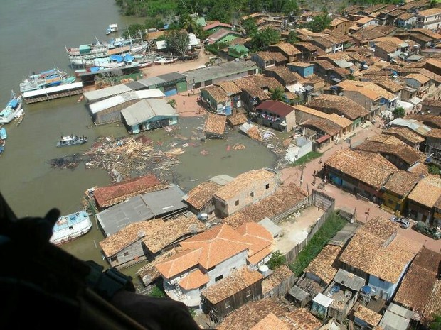
http://g1.globo.com/pa/para/noticia/2014/01/servico-geologico-do-brasil-mapeia-areas-de-risco-em-abetetuba.html
..
On the ground the landslide looks like this (from a larger gallery of images):
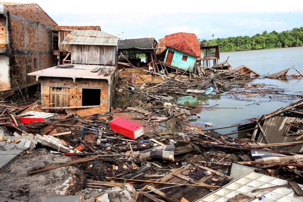
http://fotospublicas.com/tecnicos-da-cohab-atendem-vitimas-de-erosao-em-abaetetuba-e-fazem-vistoria-nos-locais-mais-atingidos/
,..
The images also indicate that other sections of the area are potentially unstable:
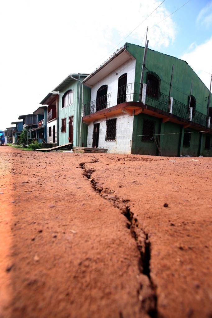
http://fotospublicas.com/tecnicos-da-cohab-atendem-vitimas-de-erosao-em-abaetetuba-e-fazem-vistoria-nos-locais-mais-atingidos/abaetetuba
..
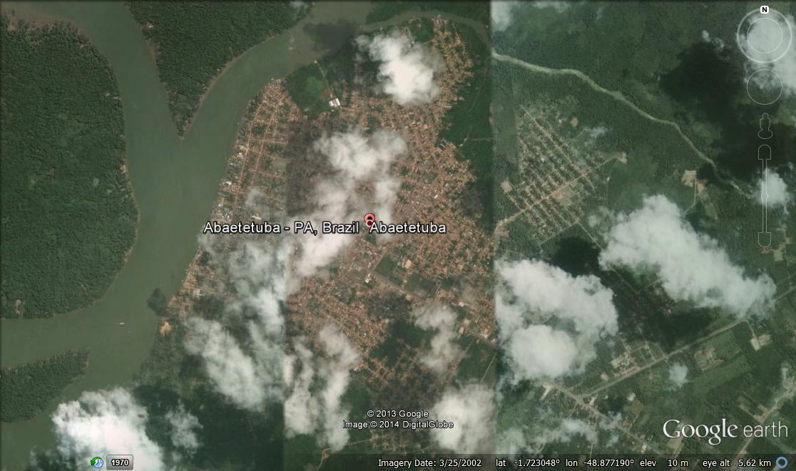
Locating the Abaetetuba landslide and the associated hazard
Unfortunately the Google Earth imagery is 12 years or so out of date, whilst the Bing Maps imagery is very low resolution, so at present I cannot find the exact location of this landslide. The challenge in the near future for the local government and their geologists will be to determine how many other houses along the river front are at risk of a similar event. They will then need to decide how to manage the hazard. If the Abaetetuba landslide had occurred at night the effects could have been far worse of course.
9 January 2014
Remarkable new video of a riverbank collapse (?) event in Abaetetuba, Brazil
http://www.youtube.com/watch?v=PSPzIWjGRaU&sns=tw
Abaetetuba or Abadetetub?
The above very interesting video has appeared on Youtube, showing a ground collapse event in Brazil. The Youtube video page suggests that this happened at “Abadetetub, Brazil “. I cannot find such a place, so I suspect that it is Abaetetuba:
Sinkhole or riverbank collapse?
A second uncertainty lies in the description of the incident, which is “The dramatic incident occurred when a sinkhole suddenly opened on a street in Abadetetub, Brazil on Saturday destroying 13 homes”. To me this is unlikely, based on the images, although I cannot say for certain. I suspect, but do not know for definite, that this is a progressive failure in fine sediments on the banks of the river, similar to this earlier example from Manuas in Brazil:
The news coverage of this most recent landslide has focused on the remarkable way in which a woman saved her child by throwing them from a window. This is highlighted in the video. The woman, who was pregnant at the time, also survived.
Has anyone seen the unedited version of this footage, or some photographs of the aftermath?
8 January 2014
Remarkable coastal change from the recent UK storms
Introduction – the recent UK storms
The recent UK storms have brought exceptionally wild coastal weather, in particular to southern and western England, Wales and Northern Ireland. This has had a profound impact on the geomorphology of the British coast. The Met Office has a nice summary of these storms. The combination of strong winds, high tides, large waves and saturated ground has greatly accelerated coastal processes, promoting failure of large rock masses. The BBC has a nice article that highlights some of these changes – for example:
Porthcothan Bay in Cornwall::
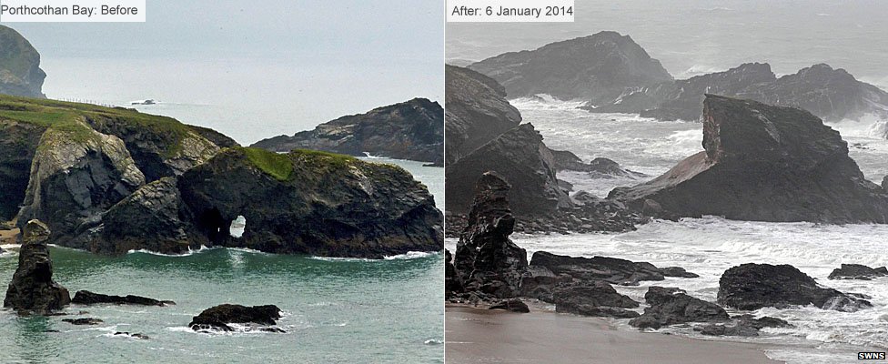
http://www.bbc.co.uk/news/uk-25639777
..
Pom-Pom Rock in Portland, Dorset:
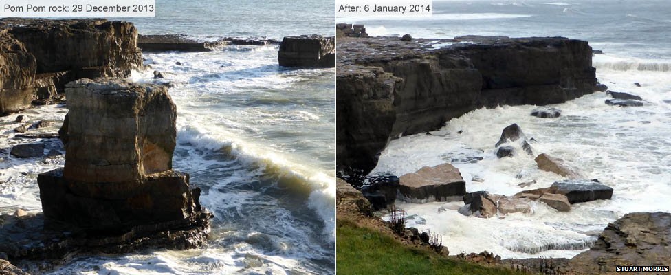
http://www.bbc.co.uk/news/uk-25639777
..
The Daily Mail has a nice set of photographs of the waves that caused this change. I expect we will see far more change once this spell of weather finally comes to an end.
7 January 2014
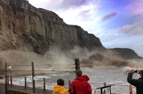
Dramatic photographs of the Hastings cliff collapse
A local paper, the Hastings and St Leonard Observer, has published two very interesting photographs of the coastal cliff collapse at Rock-a-Nore in Hastings, which was caught on video. The images were taken by a local man, Dan Crouch:
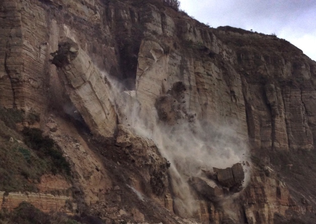
Photpgraph by Dan Crouch
Courtesy: http://www.hastingsobserver.co.uk/news/local/dramatic-landslide-photos-1-5788039
..
Photograph by Dan Crouch
Courtesy of: http://www.hastingsobserver.co.uk/news/local/dramatic-landslide-photos-1-5788039
..
Of course it is the first of the pair of photos of the Hastings cliff collapse that is the most interesting, capturing the pillars of rock mid way through their toppling movement. At this point most of the columns were intact, but note the very high level of fragmentation and disintegration at the foot of the rock blocks. This is the second collapse event, as shown in this video:
..
http://www.youtube.com/watch?v=rAmkjc7kcu0
..
The failure seems to have developed primarily through failure of rock at the foot of the unstable mass. As the columns toppled they would have induced very high levels of local stress at the bottom of the rock masses, driving very dramatic, almost explosive, local failure events. This is captured in the images.
6 January 2014
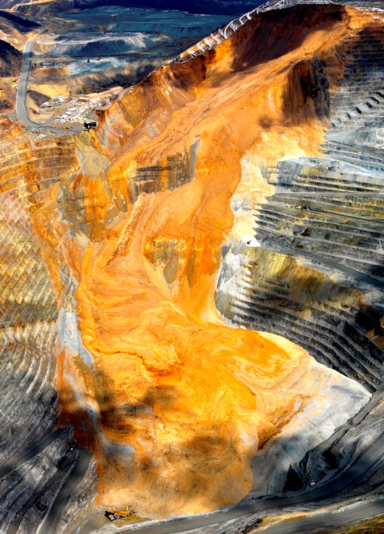
New paper review – seismic data generated by the Bingham Canyon landslide
Background to the Bingham Canyon landslide
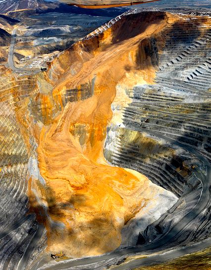
Over the last year I have posted a several times on the remarkable Bingham Canyon landslide, which occurred on 10th April 2013 in a copper mine near Salt Lake City in Utah. As a reminder, this was a very large (65 million cubic metre) slide that occurred in two phases about 90 minutes apart. As such it is perhaps the most expensive landslide in history, with costs of about $1 billion.
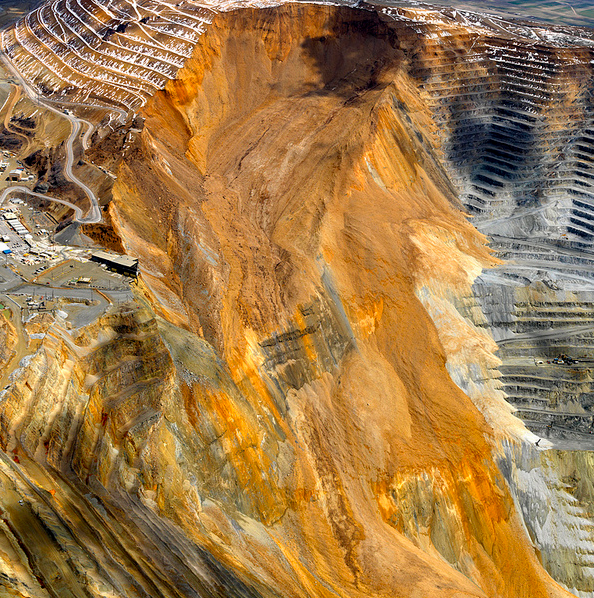
Kennecott Utah
..
In a new paper published in GSA Today, Pankow et al (2014) have reviewed the geophysical data generated by the landslide. A remarkable aspect of the landslide is the wealth of data that it has generated because of the proximity of high quality seismograph stations. In Utah there are 200 seismographs, designed to record regional earthquakes associated with the Intermountain Seismic Belt. Many of the instruments recorded the seismic signals generated by the landslide, providing an unprecedented geophysical dataset.
Analysis of the Bingham Canyon landslide seismic data
In its most simple form, it is this data that indicates that Bingham Canyon landslide consisted of two separate events – the authors point out that in general form the seismic signals from the two events are similar, but thee are key differences as well. More detailed analysis of the data suggests that the two landslides were approximately equal in volume. Pankow et al. (2014) have tried to relate this information to the nature of the deposit as seen in aerial imagery, suggesting that the first landslide traveled further (covering the pit bottom), whilst the second stopped short of the southern wall and consisted of a higher proportion of waste rock. If you look carefully at the image below (both images were provided by Kennecott Utah and are used with their permission)
Kennecott Utah
..
Other earthquakes associated with the Bingham Canyon landslide
Interestingly, the authors also point out that there were no seismic events in the vicinity of the mine in the ten days prior to the landslides. However, immediately after the second rock avalanche an ML=2.5 earthquake, and three smaller earthquakes, were detected automatically by the seismic network. More detailed analysis of the data suggests that a further 12 small earthquakes occurred in the 90 minutes between the two landslide events, a further five occurred in the two days after the landslides, and one ten days later. The characteristics of these earthquakes suggest that they were tectonic in nature, suggesting that they were aftershocks associated with the rock avalanches.
An additional resource
An additional resource on the recovery of the mine in the aftermath of the landslide can be found on page 5 of Engineering and Mining Journal. This indicates that the mine expects to resume normal operations in 2016 and that so far they are ahead of schedule.
Reference
4 January 2014
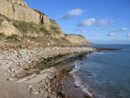
Hastings rockfall: dramatic new landslide videos from southern England
Context of the Hastings Rockfall
The context of the Hastings Rockfall is that over the last few weeks the UK has been suffering the effects of a series of exceptional low pressure systems that have swept in from the Atlantic, bringing heavy rainfall and very strong winds. Unfortunately, the onslaught continues today. The consequence has been high levels of damage (and a political fuss about funding for flood defences), and (unsurprisingly) many landslides.
The Hastings Rockfall event
Perhaps the most spectacular event captured on video to date occurred at Rock-A-Nore in Hastings in East Sussex. Most of the coverage (e.g. the Metro and the BBC) has featured the Youtube video below, but in fact this is not the best one:
http://www.youtube.com/watch?v=rAmkjc7kcu0
If you look carefully at the above video you will see that before the collapse there is a fresh scar on the cliff face. This is because the above event is the second collapse in the sequence. The first was also captured on video and is on Youtube:
The second collapse was also captured by the same person, although this video is less good:
Three aspects are interesting here. First, without the videos we would probably have considered these collapses to have been a single collapse. One of the things that the run of videos is doing is the highlight the sequential nature of failures. Second, a simple before and after analysis would have led to the interpretation that these collapses were simple rock topples, but in fact the mechanism of failure is very complex, in the case of the second set of collapses perhaps driven by compressional failure of the foot of the failing block. And third, the reason that the videos were being captured is that there was precursory rockfall activity.
Background information on the location of the Hastings Rockfall
For those interested in the location of the Hastings Rockfall, the Discovering Fossils website has a good description of the geology of the cliff, which includes this photograph taken before the collapse:
Discovering Fossils: http://www.discoveringfossils.co.uk/hastings_fossils.htm
2 January 2014
2013 landslides – the five most important events of the year
2013 landslides – context
Having taken a break from blogging (and indeed from all work) over the Christmas and New Year period, I started to ponder the most important landslides of 2013. This is of course purely subjective, but this is the list that I came up with:
1. The two debris flows at Kedarnath, India
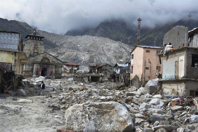
http://www.indianexpress.com/picture-gallery/first-pictures-of-devastated-kedarnath-temple/2935-1.html
..
The extreme rainfall event in Uttarakhand in June was without doubt the most deadly multiple landslide event of the year. The twin debris flows that struck the temple at Kedarnath were the defining event of the disaster, with a very complicated origin. This event also presages the types of event that we can expect in the future as the climate in high mountain areas continues to change.
2.The Bingham Canyon Landslide in Utah
http://www.flickr.com/photos/riotinto-kennecottutahcopper/8643310015/in/photostream
..
The award for the most spectacular landslide goes to the Bingham Canyon slide in Utah in April. This may well be the largest mining-induced rapid collapse of all time, and the most expensive single landslide too. That the slide was anticipated is notable, although it does appear that the volume and runout distance were somewhat greater than had been expected.
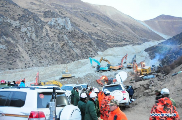
3. The Jiama / Gyama mining landslide in Tibet
http://news.xinhuanet.com/english/photo/2013-03/30/c_132273063_3.htm
..
On the subject of mining induced landslides, in March the spectacular and remarkable mining induced landslide at Jiama / Gyama in Tibet killed 83 workers. Although denied by the authorities, there is little doubt that this slide was triggered by the mining activity. The long runout and high mobility of the debris is notable, as is the continuing lack of information about the event, in notable contrast to Bingham Canyon.
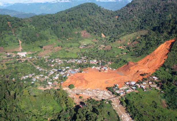
4. The La Pintada landslide in Mexico
http://www.google.com/hostednews/afp/article/ALeqM5jgxArPD5xS2gHI95daKQfXYvvyNA?docId=CNG.f3b813c83565864ba6d2d2ae56dd28ec.6c1
..
In September, a pair of tropical cyclones brought exceptional rainfall to Mexico, triggering floods and landslides. The most spectacular event occurred in the village of La Pintada, where a large landslide struck the town, killing 68 people. This is the type of event that is extremely difficult to anticipate, but deadly in terms of impact.
5. The Izu-Oshima debris flows in Japan

http://mw1.google.com/crisisresponse/2013-japan-typhoon/photos/DSC00490.JPG
..
Finally, the multiple debris flows at Izu-Oshima, triggered by typhoon Wipha, were remarkable not just for the cost in terms of lives lost (which was unusual for a more developed country), but also for the mechanisms of failure. In this case, as the image above shows, the entire side of the hill has failed in multiple shallow landslides.
Please submit your list
I am sure that you may have a different list – please feel free to post your list, or to disagree with mine, in the form of a comment.
23 December 2013
A Christmas recipe for perfect landslides
Context for the recipe
As Christmas approaches the newspapers in the UK are full of recipes for the perfect mince pie / christmas pudding / turkey. That set me thinking about the recipe for the perfect landslide. This is what I came up with:
Raw ingredients
You will need a pile of weak rocks. If these aren’t available, and shops do tend to sell out of useful things this close to Christmas, a pile of strong rocks with many joints will be a satisfactory alternative, and indeed may give some more spectacular large failures. Avoid very strong rocks with very few joints – this will give you a Scandinavian landscape, which is not completely without landslides but will tend to disappoint in terms of the frequency of events:
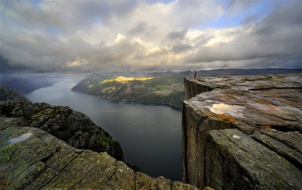
http://photorator.com/photo/7668/-pulpit-rock-preikestolen-norway-sergey-l
..
Volcanic soils are a perfect introduction to landslide generation for those looking for a quick win.
Initial preparation
Subject your rocks to a few million years of rapid uplift (I find that something over 5 mm per year will be ideal). This should create an over-steepened landscape, but to try to avoid making your landscape too steep – in this case you’ll tend to get rockfalls rather than landslides. Your landscape does need to have a decent slope gradient though. To create the perfect conditions you will need a landscape that has steep slopes right down to the rivers, but with occasional flatter areas (perhaps old river terraces) – you will see why below.
You will now need to marinade your landscape in a warm humid climate to generate really deep weathering – ideally to 20 metres depth or more. Daily temperatures of over 30 C and a millimetres of rainfall every day will be ideal. If you can get your soil to look like this then you will be doing well:
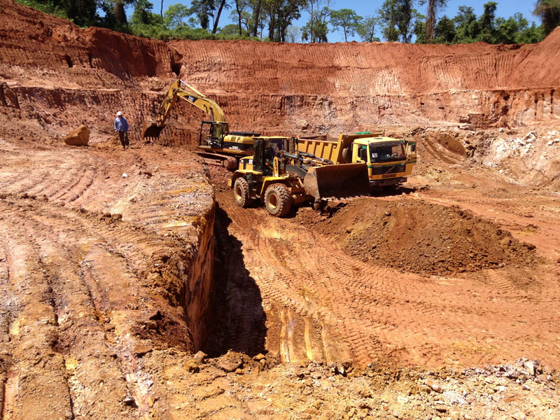
http://www.latinamericanminerals.com/gallery/photographs/
..
Shortly before you want to cook your landslides, I suggest that you completely deforest your landscape, ideally with aggressive clear-cutting to leave completely exposed soil, like this:
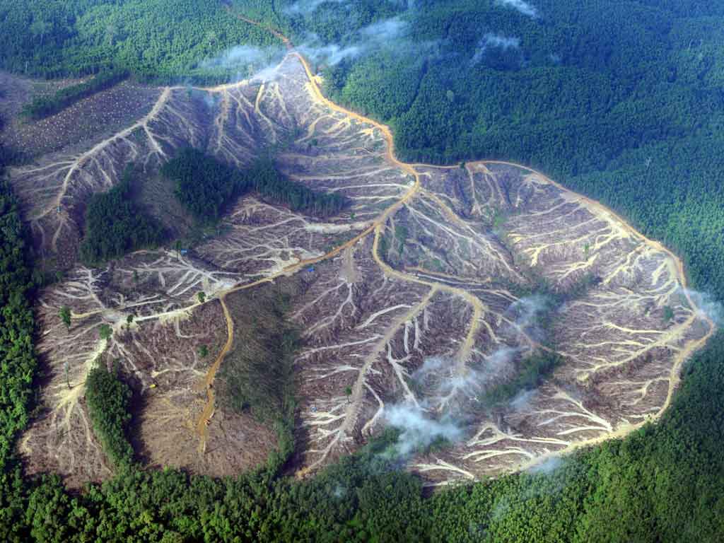
http://webeyedea.info/studentwork-11-12/3-greenpeace/daniel/pages/deforestation.html
..
Creating the correct oven environment
To get your landslides going properly you will need two key aspects to your oven environment. First, you will need very heavy rainfall. Ideally this should be occasional (every few years), very large rainfall events, either as individual storms (a strong tropical cyclone is a good example) or more prolonged rainfall with occasional cloud burst events (such as the SW monsoon or the heavy rainfall in some parts of the world associated with El Nino events). Second, you should subject your landscape to occasional strong earthquakes. Generally speaking, rare very large earthquakes will give better landslides than frequent smaller events. Very satisfactory results can be achieved by a combination of a strong earthquake followed by a large rainstorm.
Advanced landslide cooking
For those looking for a truly exceptional set of landslides, you can pep up the recipe with the actions of people. Ideally, your population should be poor, living on the isolated flatter areas you created in the landscape above, and rapidly developing. In doing so, they should throw away their traditional agricultural techniques to grow inappropriate cash crops on steep land that is being cleared. To get these crops to market the local authorities should build new roads without any assessment of the stability of the route corridor and with no engineering measures to provide drainage or to stabilise the soil. The international aid agencies will probably provide funds to support this type of approach. This example from Nepal will provide a good template:
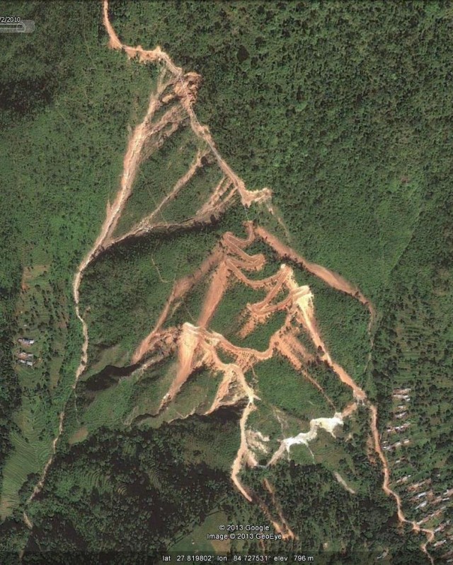
..
The impact of the landslides will be increased significantly if you encourage the local people to move from their safe terraces to live beside the road.
Serving suggestion
A light sprinkling of global warming, and in particular increased storminess and higher rainfall intensities, should keep your landslides going well into the future.
 Dave Petley is the Vice-Chancellor of the University of Hull in the United Kingdom. His blog provides commentary and analysis of landslide events occurring worldwide, including the landslides themselves, latest research, and conferences and meetings.
Recent Comments