

11 February 2014
Southern England: the potential for movement in deep-seated landslides
Extreme rainfall in southern England
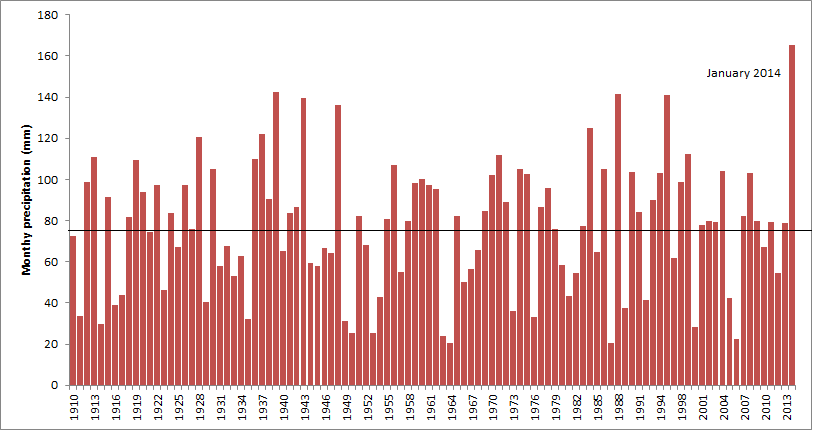
Southern England is currently undergoing an extraordinary period of exceptional rainfall, especially in the south, which is causing floods on an unprecedented scale. This rainfall, which is likely to be a consequence of climate change, shows no signs of abating, with further heavy falls expected over the next few days. Not surprisingly there have been many landslides, especially on the coast and along railway lines, and more can be expected. The UK Met Office provides monthly precipitation data for Southern England . I have downloaded the data and plotted the monthly time series from 1910 (the start of the dataset):
..
The horizontal line in the long-term mean value (77.3 mm). The 2014 total, at 165.4 mm, is 2.8 standard deviations from the mean – a truly exceptional value. And of course it is still raining, such that since the end of January the floods have got much, much worse.
Deep-seated landslides in southern England
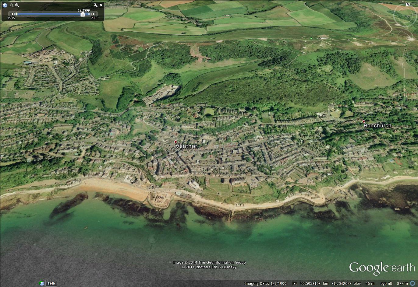
From a landslide perspective an interesting aspect of this is the likely behaviour over the next two or three months of the deep-seated landslide systems that lie along the southern coast of the UK. So far there have been few reports of these landslides showing substantial movements. However, typically deep-seated landslides show a long lag between the rainfall and the activation of movement. I can illustrate this with a dataset for a very deep-seated landslide on the Isle of Wight on the very southern tip of the UK. The landslide, at Ventnor (shown below), is very well known and has been extensively studied. It sits under most of the town:
..
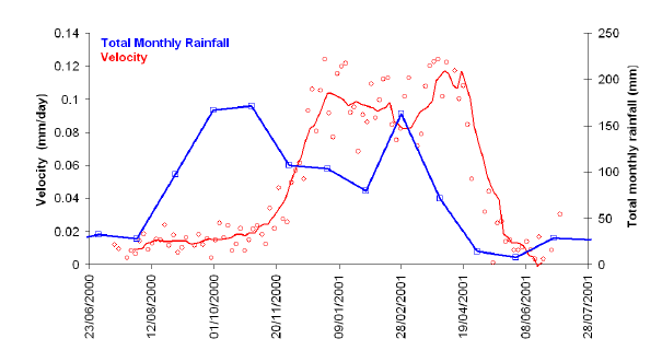
My former student, Jon Carey, studied this landslide for his PhD. In particular he monitored a phase of movement of the landslide complex from a decade ago. His thesis, which is excellent, is available for download from the Durham ethesis site. The landslide moves slowly – very slowly indeed in fact – so the level of risk for the population is low, although the town does suffer some periodic damage to buildings. The landslide is carefully monitored. This is a graph of movement rate of the landslide compared with monthly rainfall from 2000-2001:
From Carey, J. (2011): http://etheses.dur.ac.uk/3186/
Page 342
..
The monthly rainfall peaked in October and November 2000, and then fell to lower levels in the period November to January. However, the movement of the landslide only really started to accelerate in November 2001 and reached a maximum in early January. It then continued to move at a higher rate right through to the end of April, probably helped by a further wet month in February. So the lag between the rainfall and the movement was two to three months
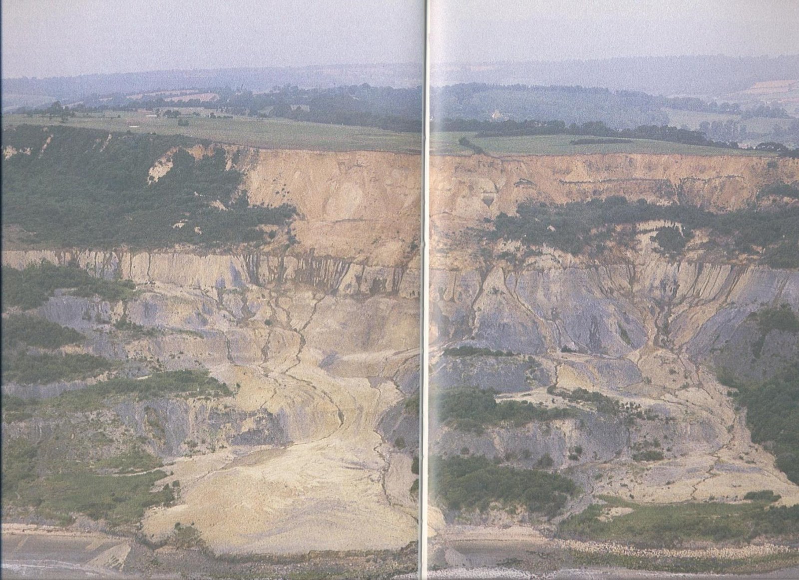
Now, as noted above, for this landslide the movement rates are very slow (typically 0.1 mm per day), so the impact is low. However, there are many other deep-seated landslides in the UK that can show much higher rates of movement – this is the spectacular (and fortunately uninhabited) Black Ven landslide in Dorset (see this post on the old home of this blog for a description of this landslide):
Photograph of the Black Ven landslide in Dorset. From Brunsden et al 1988: Landshapes. David and Charles, Newton Abbot.
..
So, we might expect to see some interesting landslide movement on the next few weeks and even months as ground water levels continue to rise in these deep-seated landslide complexes.
10 February 2014
Three interesting new videos – a slow avalanche, a coastal rockslide and a quarry slide
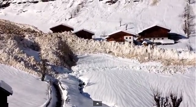
1. A slow avalanche in Italy
Whilst I don’t usually feature snow avalanches on this blog, this one is worth a look. It is a slow avalanche (the picture above is a screenshot from the film) that was captured a few days ago in Passeiertal in Sudtirol, Italy and is on Youtube:
..
The interesting aspect of this avalanche is the transition from a rapid flow into a creeping slide. Note the enormous momentum behind the slow phase of the avalanche,which was able to fell trees and small buildings with ease. The larger buildings must be very well-built! It is interesting to note the similarities with the transition in the Mount Dixon rock avalanche from last year (see my posts here and here), which also transitioned from a flow to a creeping mass:
..
Several people brought this one to my attention – thanks to you all.
2. A small landslide from Devon
This small landslide was captured at Lusty Glaze (what a great name!) on the coast of Devon in SW England on 1st February:
..
3. A rockslide in a quarry
Thanks to Thomas Hodgson for pointing out this video, which has been online for over three years but had passed me by. It is not clear where it happened, as the commentary says only: “Textbook example of footwall failure / collapse in a coal mine on a previously unidentified fault plane.”
7 February 2014
The Seti River debris flow in Nepal – what was the role of the smaller landslide downstream?
A reminder about the Seti River debris flow
In May 2012 a debris flow swept down the Seti river in Nepal, taking 72 lives and causing considerable damage. Long term readers will remember that a day after the debris flow I suggested that there might be a landslide cause, and that a few days later, thanks mainly to help from Colin Stark, we identified that a large landslide was likely to have been the trigger. Over the next few days, and thanks to help from numerous people, we pieced together the the sequence of events. Although there were those that disagreed with our interpretation at the time, our initial analysis has subsequently proven to be correct. This does make it somewhat galling to see a NASA article entitled “One Scientist’s Search for the Causes of the Deadly Seti River Flash Flood“. One scientist? Not at all – this was a huge team effort.
Anyway, an interesting aspect of that article, by Jeff Kargel, is the suggestion that the debris flow was caused by a secondary landslide downstream that had blocked the valley, creating a lake. In this theory, the rock avalanche that swept down from the flanks of Annapurna IV triggered the breach of the landslide dam, releasing the destructive debris flow. The NASA article maintains that this was a significant factor:
However, the more we searched, the more it became evident that this was definitely not a GLOF, but was caused by a rockslide into the Seti River gorge, formation of an impoundment reservoir over a several week period due to damming of spring snow and ice melt, and then the final triggering event of the mighty rock and ice avalanche off Annapurna IV.
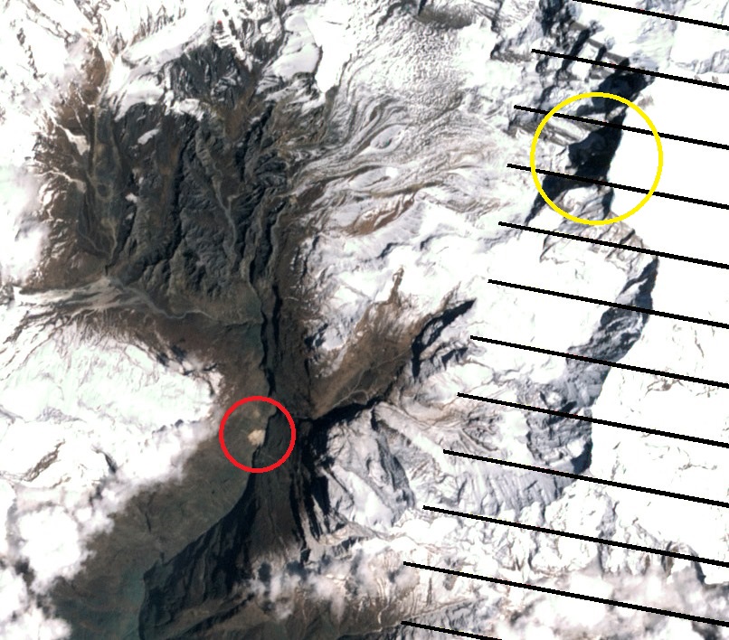
Odd wording given that we had already clearly shown that this was not a GLOF, but there you are. Anyway, does this idea of a landslide dam being the source of the water and sediment stack up? Well, the first thing to note is that this landslide was certainly present in the gorge. The scar is visible in the Landsat 7 ETM+ imagery that NASA collected a few days before the landslide, and an image taken a few days before the Seti River debris flow also shows it clearly. This is the image collected before the rock avalanche:
 …
…
I have highlighted the landslide in red on the image above – it is clearly visible. For reference the cliff that collapsed to generate the initial rock avalanche is the area highlighted in yellow. I’m afraid that in my view the evidence supporting the idea of a landslide dam and lake runs out from this point.
Kargel’s idea is that, as we identified, the rock avalanche sent a proportion of debris down the very steep gullies into the main channel. This debris then caused the failure of the landslide dam, generating the debris flow. The above image was collected on 20 April 2012, about a fortnight before the rock avalanche. Colin and I looked at this imagery at the time, and we maintained that there was no need for this smaller landslide to play a role. I retain that view.
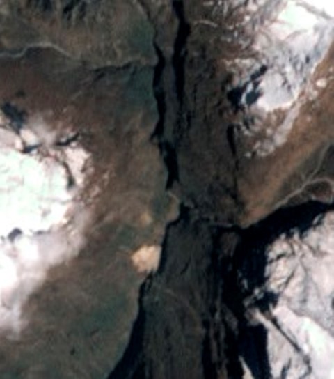
The first problem that I have with the Kargel model of a valley blocking landslide theory is the lack of evidence for a lake in the satellite imagery. Lets zoom in to the section just upstream of the landslide itself – again this is the 20 April 2012 (i.e. before the rock avalanche) image:
..
Of course we get into resolution problems (hence the blurred nature of the image), but I see no evidence at all for a water body upstream of the blockage. Perhaps it is hidden in the shadows, but if so it could not be a very substantial body of water, surely?
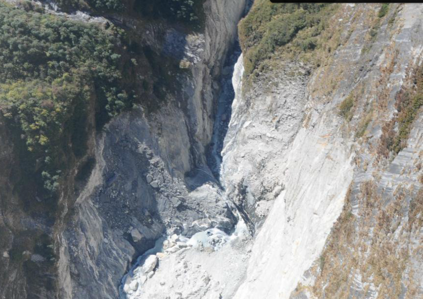
The second problem I have with this is that for a breach event to release a catastrophic debris flow we should see a huge breach scar in the landslide debris – remember that this is a catastrophic collapse event. Well, Dhananjay Regmi has a presentation online that includes a helicopter image of the landslide:
Dananjay Regmi: http://issuu.com/johnharlinmedia/docs/regmi_investigationsetiriverdisaste?e=7165924/4998805
..
To me this does not look like the aftermath of a catastrophic breach event. Maybe there has been post-breach modification of the channel? But actually there is no evidence of lake deposits in the image either.
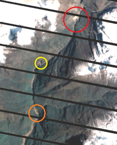
The third aspect that I find hard to understand is the downstream morphology of the channel in the post-debris flow NASA image. This is the view of the channel downstream of the landslide a few days after the Seti River debris flow:
 ..
..
I have highlighted the landslide in red. There is a key point to understand about landslide dam breach events. This is that the flood wave should be at its largest at the dam crest. As the wave passes down the channel from that point it attenuates – reduces in height. So, the impact should be at its maximum immediately below the dam, and this should steadily diminish downstream. Does that happen in the image above? I hope that you can see that the exact opposite occurs. The impact on the channel clearly gets larger and wider downstream – compare just below the landslide with the yellow circle – downstream the flood has clearly become larger, and even more so by the time it reaches the orange circle, and it gets even bigger thereafter. This is not a dam breach flood. Actually, this is the signature of a debris flow that is accumulating volume en route down the valley.
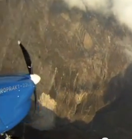
Still don’t believe me? Well, OK, I’ve saved the best for last. You see when Captain Maximov videoed the rock avalanche he also caught this smaller landslide in the film. He captured an image of it on his first orbit, which is about the time the landslide started. This is a still from the video:
 ..
..
The landslide is directly below the nose of the plane, upstream is to the right. There is no lake, even though this was taken as the rock avalanche initiated..
So what happened? The increase in size of the debris flow scar downstream suggests that the debris flow was entraining its bed (over-running and incorporating river bed sediments) as it travelled downstream. This is a very well-established process in debris flows, and it is not exotic.Most importantly, it explains all of the observations outlined above.
So the downstream landslide did not play a major part in this tragedy, and this was not a dam break flood.
2 February 2014
Jalan Kenanga: A video of a retaining wall failure in Malaysia
Jalan Kenanga (Ho Ching Yuen) retaining wall video
This isn’t a new video, but I haven’t come across it before. It shows the progressive failure of a retaining wall at Ho Ching Yuen, which I believe is more commonly known as Jalan Kenanga, in Kuala Lumpur, Malaysia:
..
Some observations
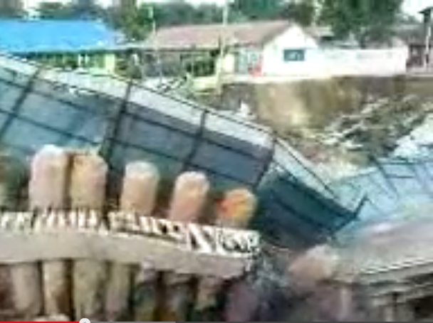
If you can, play it with the sound on – it is fascinating to hear the bangs and crashes as the structural elements fail to generate the rapid movement event. It is also interesting to note that the ground behind the wall appears to have already collapsed at the time of failure, as the screenshot below shows:
 ..
..
I think, but don’t know for certain, that this event is the one reported here. If so, this appears to be what happened, in July 2009:
Eyewitness Umihani Sudin, a resident at the JKR quarters affected by the cave-in, said the road had gradually collapsed at 4.30pm on Saturday and, two hours later, a large section of the area near her home was literally swallowed by a large gaping hole near the construction site of a wholesale mall.
“We saw with our own eyes how the road sank and the project’s retaining wall had given way,” she said.
She was referring to the project site of Kenanga Wholesale City in Jalan Merlimau, off Jalan Kenanga, in Cheras, with the San Peng flats in the background, where part of it had caved in last Saturday evening.
The article blames a burst water pipe for the failure. That is possible, but it could also be that inadequate design of the piles led to deformation that in turn ruptured the pipe. In other words, the burst pipe could well be a symptom rather than the cause of the failure.
30 January 2014
Nord-Statland: A landslide-induced tsunami on Wednesday that caused serious damage
The Nord-Statland tsunami
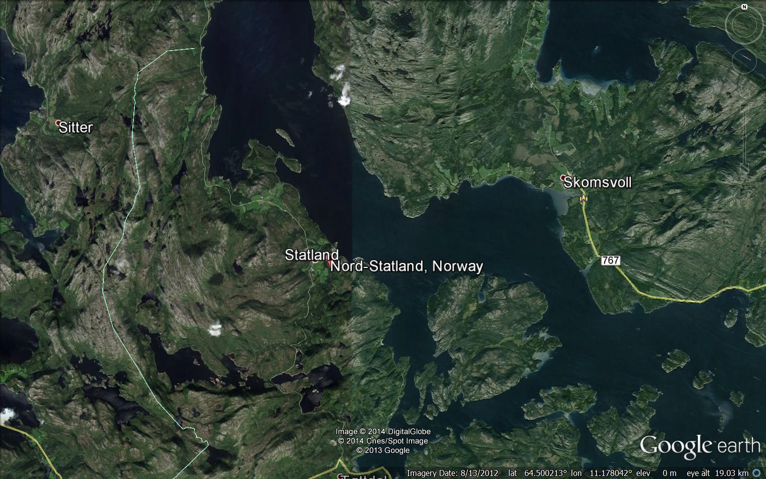
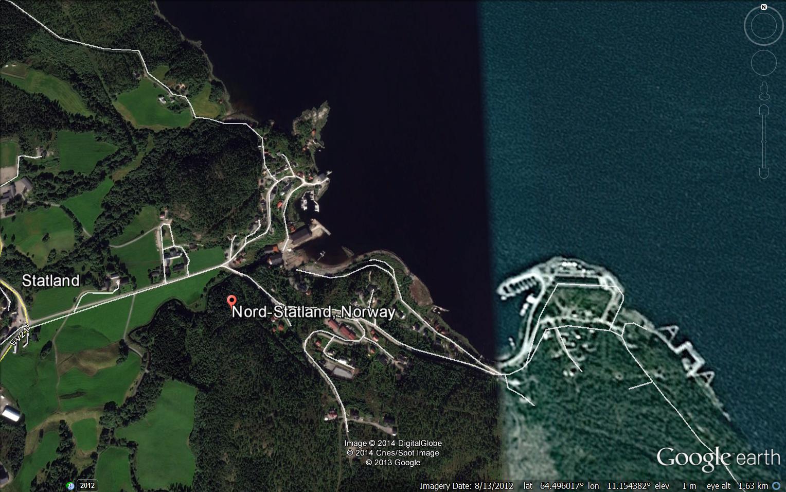
At about 4:30 on Wednesday afternoon, the small Norwegian village of Nord-Statland was struck by a localised tsunami, which reports have suggested was as high as 15 m (though this looks unlikely). The village is located in Nord-Trøndelag, as shown below in Google Earth:
…
A close-up of the village looks like this:
…
The damage to the village is very serious. This is a pair of before and after images from nrk.no:
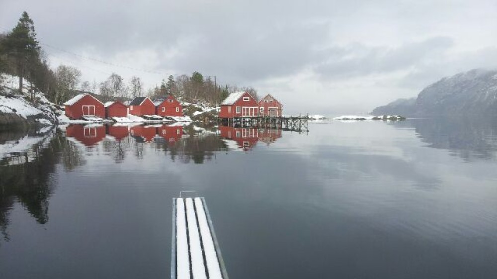
http://www.nrk.no/trondelag/_-kunne-blitt-en-katastrofe-1.11507175
After:
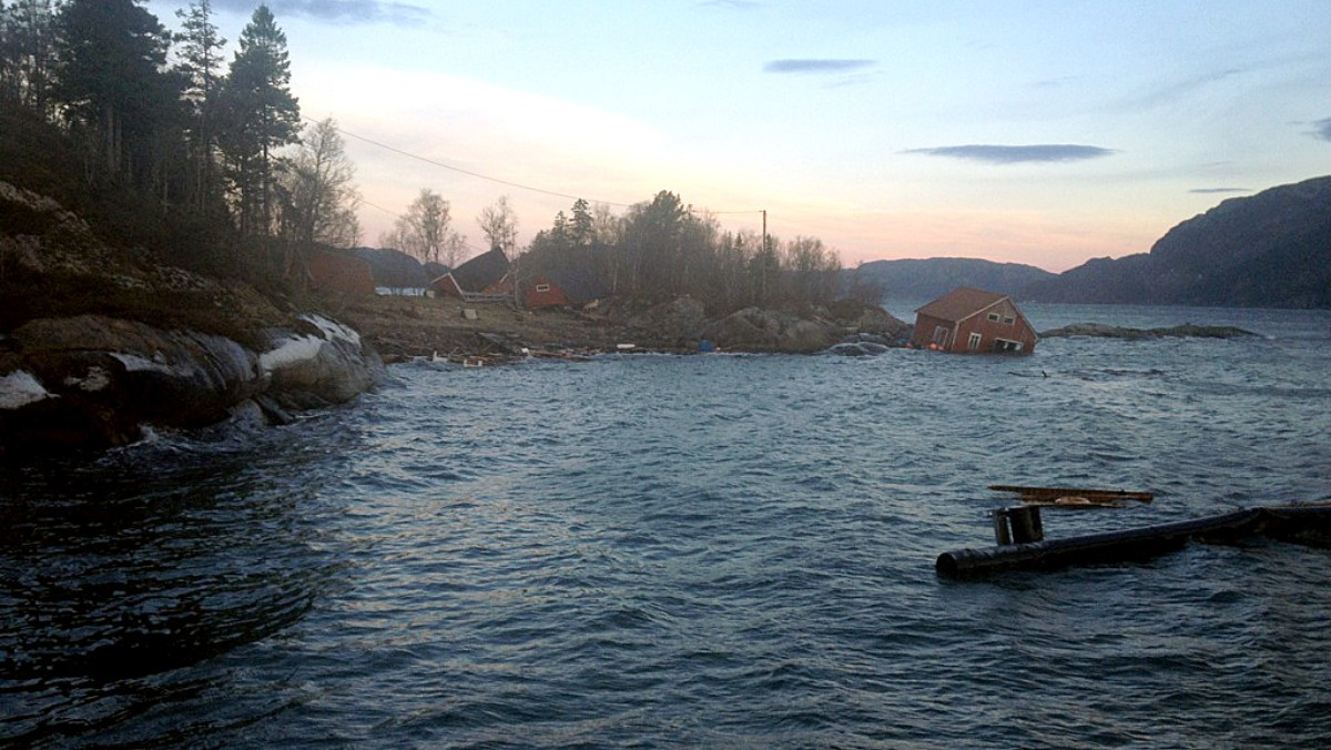
http://www.nrk.no/trondelag/_-kunne-blitt-en-katastrofe-1.11507175
…
Whilst this is the area further around the bay (from this gallery of images):
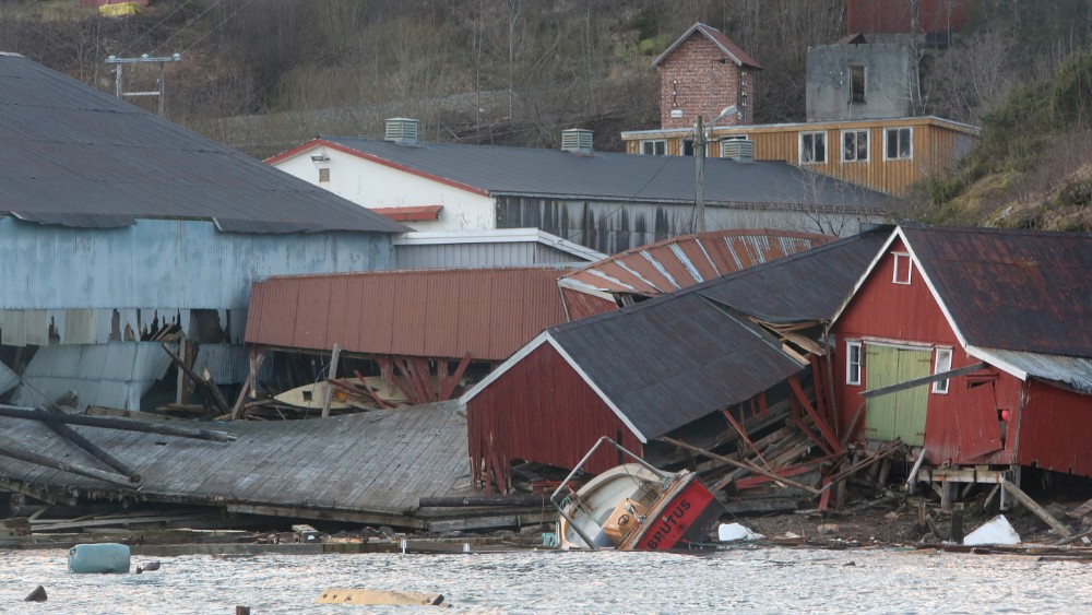
http://www.nrk.no/trondelag/to-ars-produksjon-kan-vaere-tapt-1.11507388
…
Finally, this is image, from http://www.adressa.no/, shows the immediate aftermath of the tsunami:
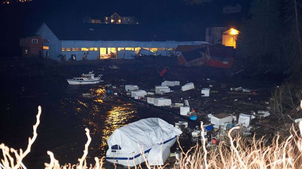
http://www.adressa.no/nyheter/nordtrondelag/article9040275.ece
…
The cause of the Nord-Statland tsunami
The highly localised impacts of this tsunami, and the lack of sesmicity, suggest that this was a landslide-induced event. Reports (in Norwegian) suggest that there was a landslide on the other side of the fjord. However, according to this report, the landslide scar is too small to have caused the observed tsunami, which suggests that the cause was a submarine landslide within the fjord. This report (also in Norwegian) suggests that the cause may have been new houses and a marina under construction close to the village – as far as I can tell it is describing these houses:
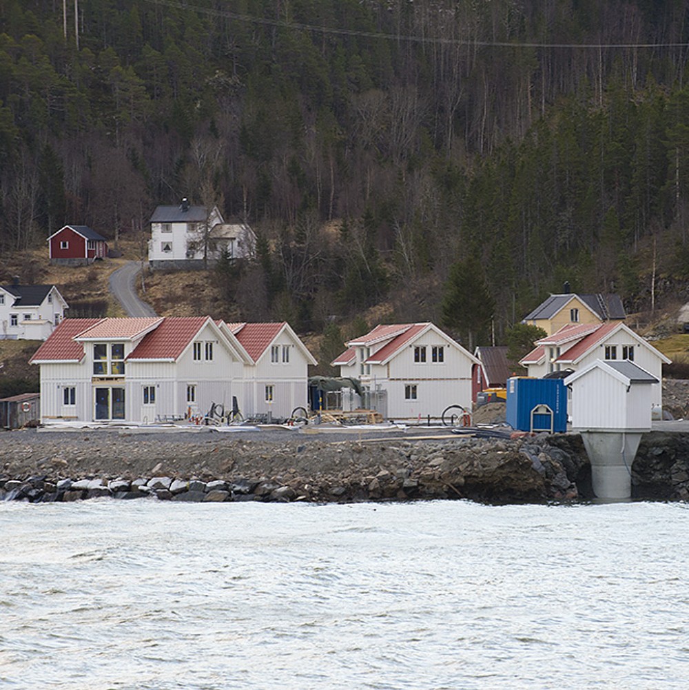
http://www.nrk.no/trondelag/flodbolgen-kan-skyldes-fyllmasse-1.11507332
..
The suggestion is that the disposal of spoil from these works triggered an underwater slide that in turn generated the tsunami. Whatever the cause, the upshot is that 57 people have been evacuated, but fortunately no-one was killed. The damage to this small village looks to be very serious, including a million fish in a smolt plant. The effects could have been much worse if the landslide had occurred in the summer.
29 January 2014
The Keystone Canyon avalanche in Alaska, and its large ice-dammed lake
The Keystone Canyon avalanche
I do not usually cover snow and ice avalanches in my blog, but the recent Keystone Canyon avalanche, and other avalanches on the Richardson Highway in Alaska, requires that I make an exception. The largest of many avalanches occurred on Monday at Keystone Canyon as a consequence of the recent combination of exceptional temperatures and high levels of precipitation through the winter (Jeff Masters has a blog post about the meteorology of this event). It appears that there were actually two large avalanches at Keyston Canyon, one natural and one caused by blasting to try to remove the remaining unstable snow. The net effect of this has been to block the Richardson Highway, the only road to the town of Valdez (population 4,000) people. The best view of the avalanche deposit is a video from a helicopter that flew over the site:
…
Unfortunately I know nothing about the processes of clearing an avalanche from a road, especially one that is trapping a large, deep lake behind it, but I am sure that this will be very challenging. This news report suggests that the plan will be to allow the lake to drain naturally before starting to clear the snow and ice, and other reports suggest that the lake level is falling. Anchorage Daily News is reporting today that clearing of the other avalanches on the road has started, but that because of the impounded water at Keystone Canyon there is no estimated date upon which the road will be fully reopened.
Images of the Keystone Pass avalanche
Anchorage Daily News also has a gallery of images of the Keystone Canyon Avalanche. I think the best impression of the scale can be gained from this view, taken by the Alaska Department of Transportation and Public Facilities:
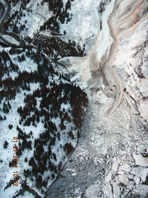 …
…
Whilst this image shows the magnitude of the task facing the work crews:
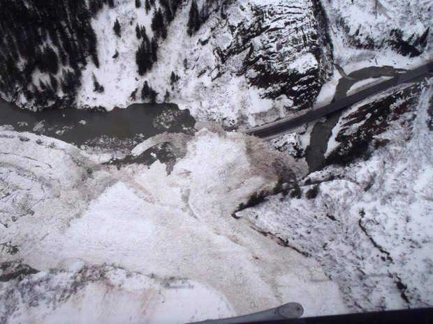
Alyeska Pipeline Company
..
And on a lighter note, it is hard not to smile at this warning sign on the flooded road. No kidding!
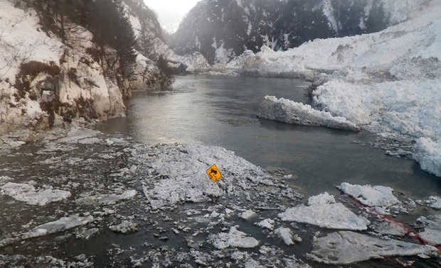
Alaska Department of Transportation and Public Facilities
Acknowledgements
Thanks to Lee Allison, Greg Springer, Bryan O’Sullivan, Andrew Giles, Lockwood DeWitt and others for help with this post.
Tramin (Termeno), Italy: a very dramatic rockfall
The original Tramin (Termeno) rockfall
On 21st January about 4000 cubic metres of rock detached from a near vertical rock cliff at Tramin, South Tyrol, Italy. (This is the German speaking part of northern Italy – in Italian this place is known as Termeno in case you are confused by the reports). The rockfall appears to have been caused by the catastrophic collapse of a rock pillar. The major part of the debris consisted of a number of enormous boulders that slid and rolled down the slope before striking a 300 year old building below. SudTirol News has a nice image that provides an overview of the event, including the site of the original pillar and the track of the debris:
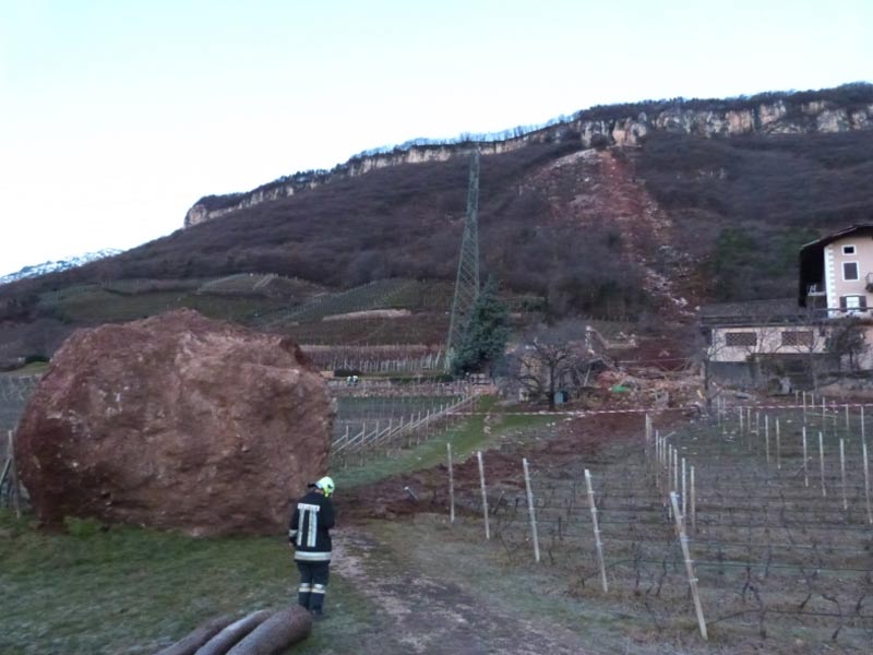
http://www.suedtirolnews.it/d/artikel/2014/01/22/tramin-riesige-felsbrocken-donnern-zu-tal.html
..
However, the best gallery of images of the Tramin rockfall (there are 12, and they are all classics) is on the Salto Wirtschaft website. This image shows the effects of one of the boulders on a 300 year barn, which it rolled straight through:
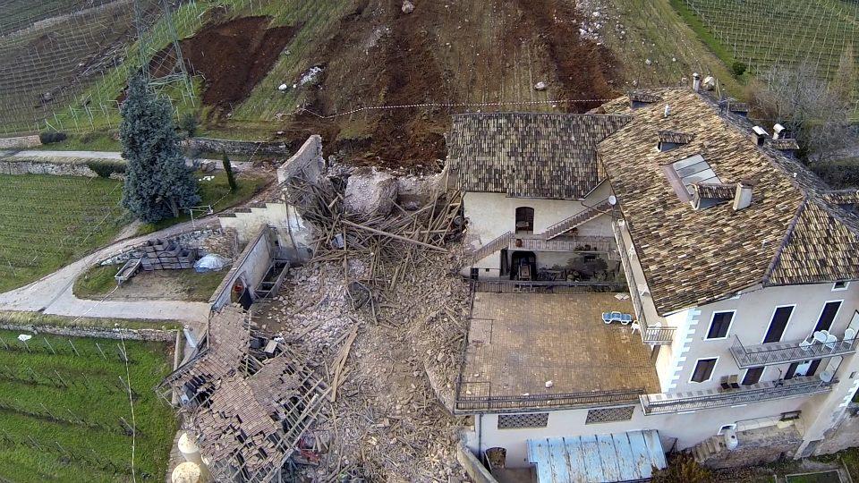
http://salto.bz/de/article/26012014/steinschlag-tramin-gigantische-luftaufnahmen
…
The boulder continued rolling downslope, and eventually stopped in a field. Interestingly, the other (even larger) boulder in the field is from an earlier event, so the level of hazard was clear:
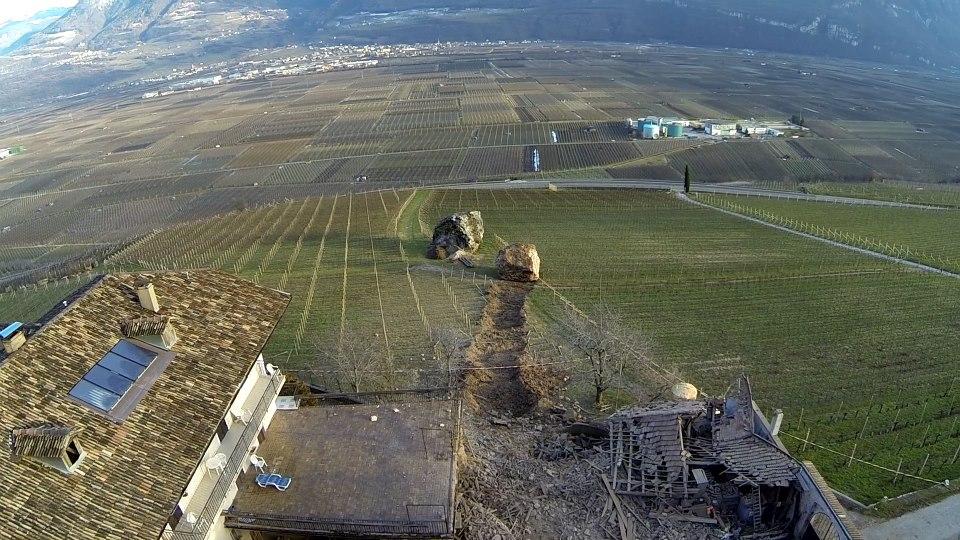
http://salto.bz/de/article/26012014/steinschlag-tramin-gigantische-luftaufnahmen
..
Whilst this boulder stopped moving just as it reached the main part of the building – a very lucky escape for the house and its occupants:
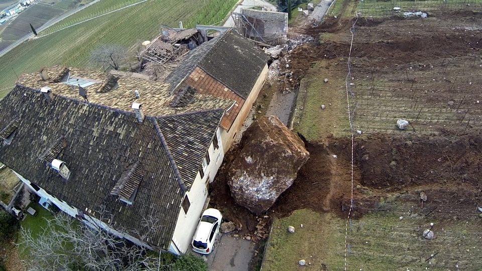
http://salto.bz/de/article/26012014/steinschlag-tramin-gigantische-luftaufnahmen
..
A really interesting aspect of this event at Tramin is the nature of movement of the boulders. They have both left extremely deep furrows in the soil, but I am sure that they were rolling rather than sliding, and hence the undulating nature of the levies on either side of the track:
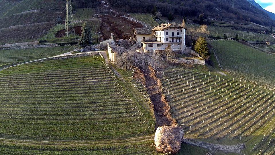
http://salto.bz/de/article/26012014/steinschlag-tramin-gigantische-luftaufnahmen
..
Mitigating the remaining hazard at Tramin
The rockfall left a tower of rock in place that needed to be mitigated, so over the last few days blasting has been undertaken to try to remove the remaining material. This UAV video shows rather nicely the site and the dangerous pillar:
Whilst this video (which I cannot embed) shows the effects of some of the blasts, including much smaller boulders tumbling down the slope.
Acknowledgement
Thanks to Dr Bill Murphy of the University of Leeds for pointing this one out to me.
27 January 2014
Port Hills, Christchurch: demolishing the rockfall threatened houses
The Port Hills rockfall problem
The Port Hills area on the edge of Christchurch was very seriously affected by the Christchurch earthquake sequence. The Canterbury Earthquake Recovery Authority will today start the process of demolishing the rockfall affected houses in the Port Hills area. Yesterday they released a statement describing the challenges of this work; this statement is well-covered in an article in The Press, which also includes a nice video taken by a drone of some of the sites. A couple of years ago I visited many of these sites, and I have an old post that presents some of the images that I collected. As a reminder, this is typical of the state of some of the buildings at the top of the slopes on the Port Hills:
 ..
..
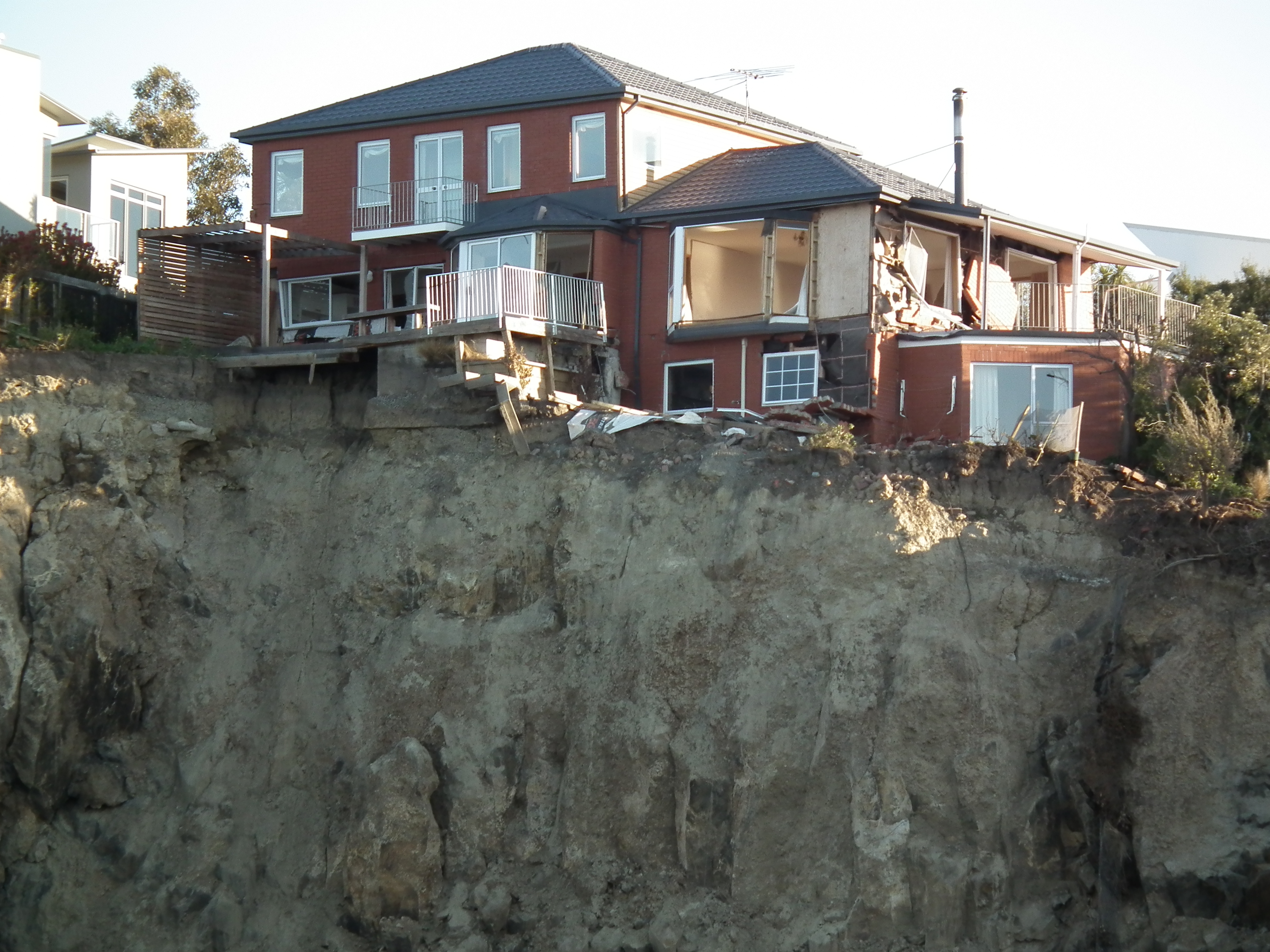
..
And this is the state of some of them at the cliff toe:
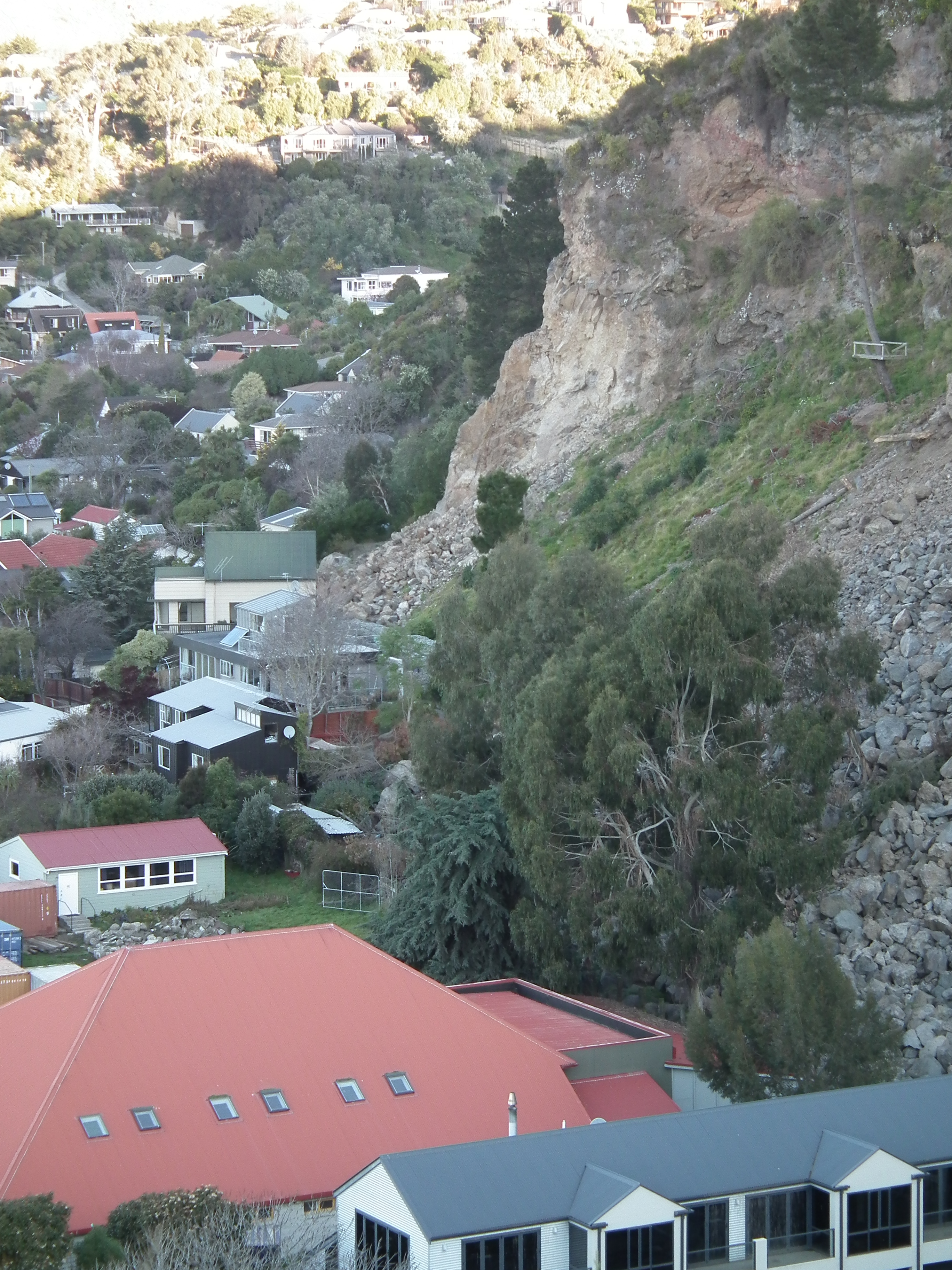
..
Hazards from demolishing rockfall affected houses
Demolition of such houses is extremely difficult and can be dangerous. At the foot of the slope the workers will be exposed to further rockfalls, although this is a manageable risk with care. CERA have been using shipping containers to provide protection to vulnerable infrastructure, and the statement says that they will do so again
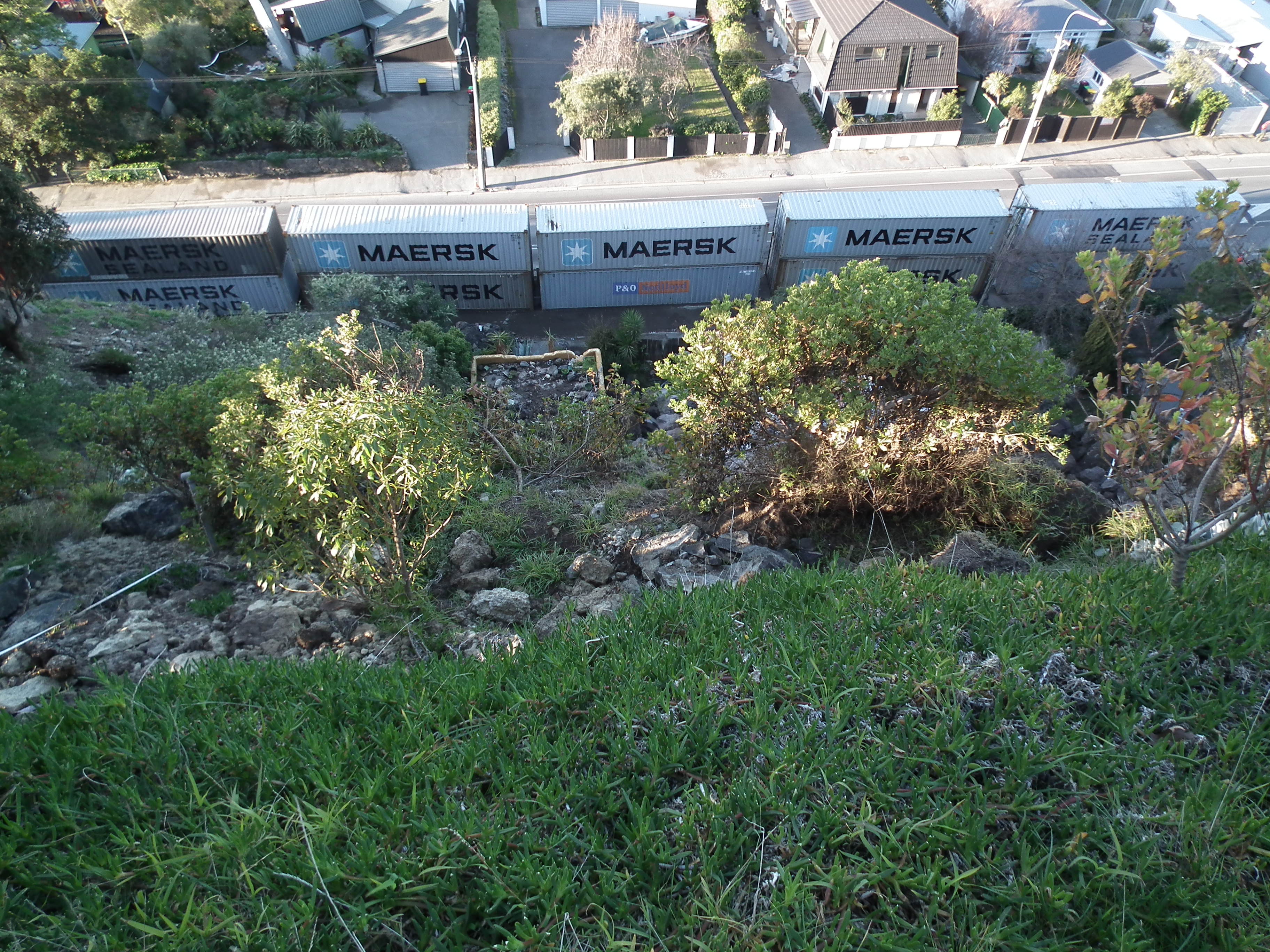
..
A greater challenge may lie in the buildings at the top of the slope. Many of these are precarious, one building may be supporting another, and in some cases the buildings may even be supporting the cliff:
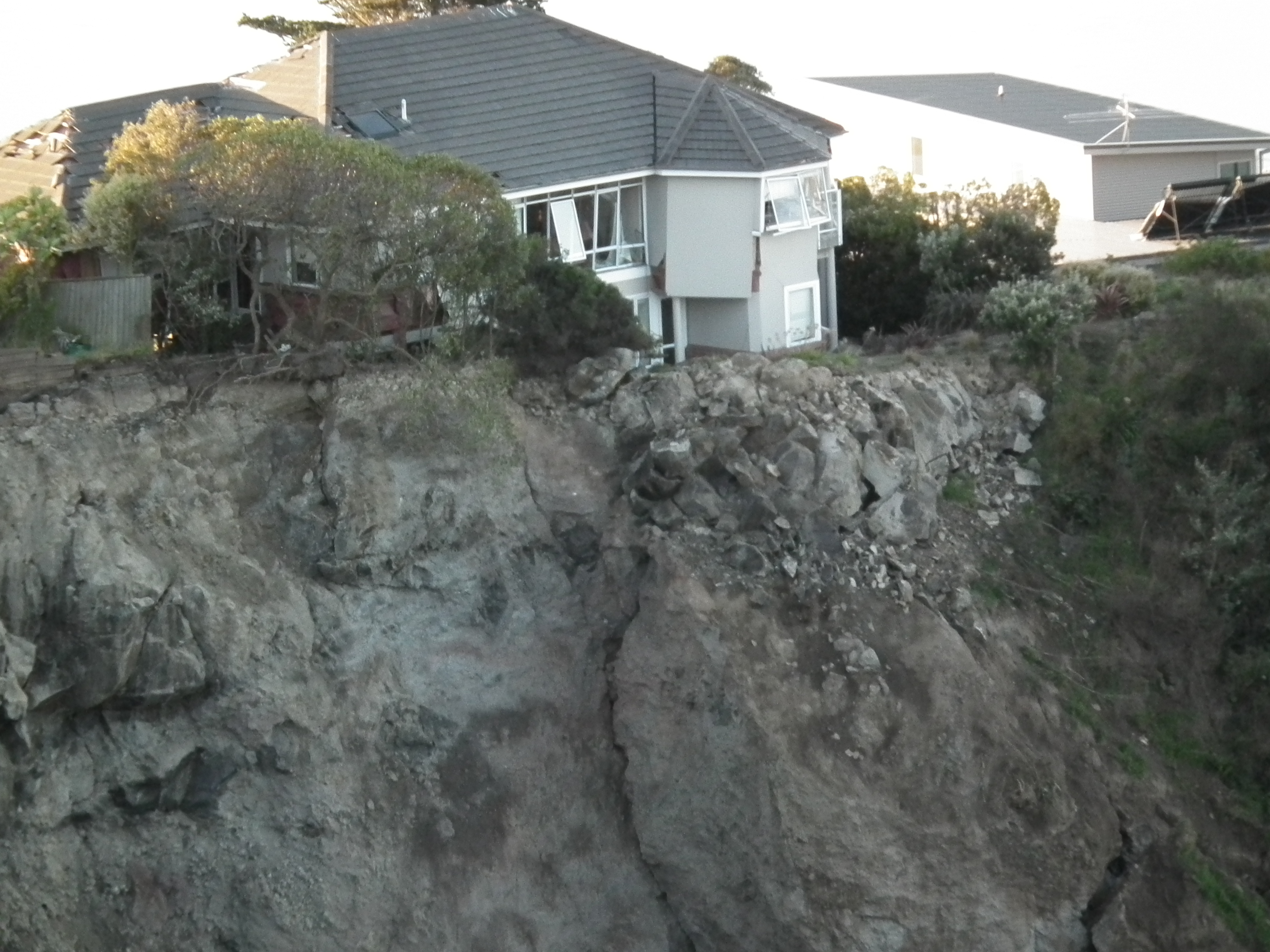 ..
..
For this reason, CERA will proceed with this work very cautiously and will use a range of techniques, including blasts and water blasters. I have no doubt that they will complete the work safely, but the challenges that they face are severe.
All of the background information to the hazard from rockfalls in the Port Hills area is available online on the CERA and CCC websites.
25 January 2014
The Seti River rock avalanche in Nepal – a new image from the International Space Station
The Seti River landslide
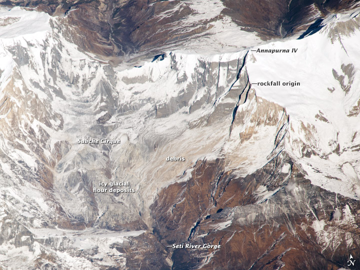
In early May 2012 an enormous rockfall occurred on the flanks of Annapurna IV in Nepal, triggering a debris flow that traveled rapidly down the Seti River towards the town of Pokhara. The debris flow struck many small communities en route, killing more than 60 people. Over the following days we used this blog to piece together an account of the events – this has subsequently been shown to be correct, although there is still some discussion about the transition from rock avalanche to debris flow. I for one am surprised to hear that the small rockslide downstream played a key role in generating the flow, and would be interested in seeing the actual evidence for a lake behind the landslide dam.
On 22nd December 2013 an astronaut from the International Space Station managed to photograph the rockfall site. NASA have now posted this image on their website, together with a slightly surprising account of how the sequence of events was pieced together, and who undertook this work. The image is quite lovely:
http://earthobservatory.nasa.gov/IOTD/view.php?id=82937
..
Whilst I’m not sure that this new image adds a great deal to our understanding of the landslide, it does provide a stunning panoramic view of the site, which is surely one of the most interesting landslides of the last few years.
19 January 2014
Torrential rain in Italy and France, especially in Liguria, causes landslides
Liguria landslides
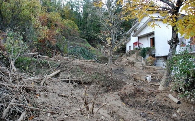
Over the last few days northwestern Italy and southeastern France have been suffering from intense rainfall, triggering widespread landslides.Worst affected seems to the Liguria region of Italy, for which reports suggest that the highest level of alert has been issued. I have been able to track down the following images of some of the landslides that the rainfall has triggered (note that all of the links are to Italian websites):
La Presse reports that over 100 landslides have been triggered in Liguria alone, and includes this image of one of them:
http://www.lapresse.it/cronaca/maltempo-in-liguria-oltre-100-frane-e-almeno-200-evacuati-1.446933
..
The newspaper Republicca has probably the best gallery of images, including this one:
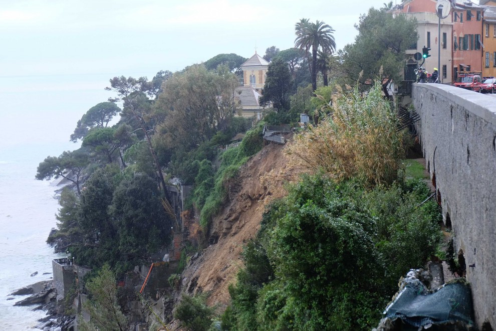
http://genova.repubblica.it/cronaca/2014/01/19/news/maltempo_allerta_fino_alle_15_strade_riaperte_ma_ancora_frane-76346580/#gallery-slider=76364923
La Stampa reports on probably the most spectacular event, the derailing of an express train near between Andora (Savona) and Cervo (Imperia). This was astonishingly close to a very serious accident:
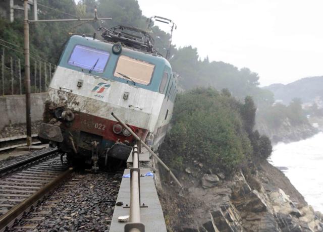
http://www.lastampa.it/2014/01/17/multimedia/italia/liguria-frana-sui-binari-deraglia-un-intercity-nvpBrPr32qJvwWcx2HmEgM/pagina.html
..
This is clearly not a simple case of debris on the tracks:
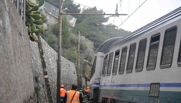
http://www.lastampa.it/2014/01/17/multimedia/italia/liguria-frana-sui-binari-deraglia-un-intercity-nvpBrPr32qJvwWcx2HmEgM/pagina.html
..
This landslide will be rather complex to repair.
 Dave Petley is the Vice-Chancellor of the University of Hull in the United Kingdom. His blog provides commentary and analysis of landslide events occurring worldwide, including the landslides themselves, latest research, and conferences and meetings.
Recent Comments