
6 January 2014
New paper review – seismic data generated by the Bingham Canyon landslide
Posted by Dave Petley
Background to the Bingham Canyon landslide
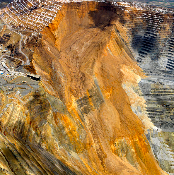
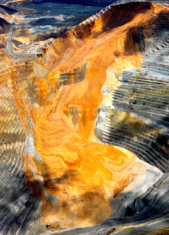
Over the last year I have posted a several times on the remarkable Bingham Canyon landslide, which occurred on 10th April 2013 in a copper mine near Salt Lake City in Utah. As a reminder, this was a very large (65 million cubic metre) slide that occurred in two phases about 90 minutes apart. As such it is perhaps the most expensive landslide in history, with costs of about $1 billion.
Kennecott Utah
..
In a new paper published in GSA Today, Pankow et al (2014) have reviewed the geophysical data generated by the landslide. A remarkable aspect of the landslide is the wealth of data that it has generated because of the proximity of high quality seismograph stations. In Utah there are 200 seismographs, designed to record regional earthquakes associated with the Intermountain Seismic Belt. Many of the instruments recorded the seismic signals generated by the landslide, providing an unprecedented geophysical dataset.
Analysis of the Bingham Canyon landslide seismic data
In its most simple form, it is this data that indicates that Bingham Canyon landslide consisted of two separate events – the authors point out that in general form the seismic signals from the two events are similar, but thee are key differences as well. More detailed analysis of the data suggests that the two landslides were approximately equal in volume. Pankow et al. (2014) have tried to relate this information to the nature of the deposit as seen in aerial imagery, suggesting that the first landslide traveled further (covering the pit bottom), whilst the second stopped short of the southern wall and consisted of a higher proportion of waste rock. If you look carefully at the image below (both images were provided by Kennecott Utah and are used with their permission)
Kennecott Utah
..
Other earthquakes associated with the Bingham Canyon landslide
Interestingly, the authors also point out that there were no seismic events in the vicinity of the mine in the ten days prior to the landslides. However, immediately after the second rock avalanche an ML=2.5 earthquake, and three smaller earthquakes, were detected automatically by the seismic network. More detailed analysis of the data suggests that a further 12 small earthquakes occurred in the 90 minutes between the two landslide events, a further five occurred in the two days after the landslides, and one ten days later. The characteristics of these earthquakes suggest that they were tectonic in nature, suggesting that they were aftershocks associated with the rock avalanches.
An additional resource
An additional resource on the recovery of the mine in the aftermath of the landslide can be found on page 5 of Engineering and Mining Journal. This indicates that the mine expects to resume normal operations in 2016 and that so far they are ahead of schedule.
 Dave Petley is the Vice-Chancellor of the University of Hull in the United Kingdom. His blog provides commentary and analysis of landslide events occurring worldwide, including the landslides themselves, latest research, and conferences and meetings.
Great reporting on a massive landslide due to anthropogenic reasons. Bingham Canyon landslide in Utah is another human-induced natural calamity and warrants immediate attention from the exploration companies in terms of providing safety and minimizing possibility of such events from taking place somewhere else. There should be strict regulations and mining practices must adhere to providing environmental safety and follow regulated mining protocols.
[Agreed – but to be fair all of these thibgs were and are in place in the case of Bingham Canyon. Although the landslide is an economic catastroiphe, in terms of landslide saftey this event is a big success – D]