
18 December 2013
A dramatic new landslide video from Minas Gerais, Brazil
Minais Gerais landslide video
Heavy rain in Minas Gerais, Bazil in recent days has generated large numbers of landslides. One of these, in Minas Gerais, killed a family of six people. This slide has apparently been caught on video, which is on youtube:
https://www.youtube.com/watch?v=H3aiqai3Drw
..
From the video I think the component captured on the film is a small, later stage event that followed the main failure. The slide appears to have been very translational in nature (there is an almost planar shear surface) but very rapid with a long runout. The image below, from O Tempo, supports this interpretation:
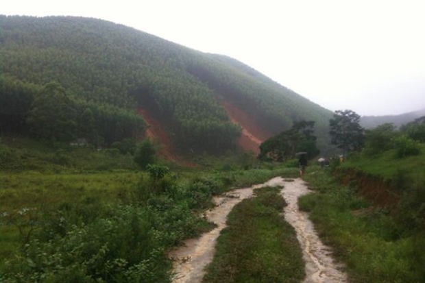
..
The landslide location and details of the events
News reports suggest that this occurred on Tuesday, although there is little more information in English. This news report (in Portuguese) explains what happened (this is the Google translate version, with some edits from me for clarity):
Six people died on Tuesday (17 December), buried by a landslide caused by heavy rains in the rural municipality of Sardoá, located about 110 km from Governador Valadares, in eastern Minas Gerais. According to firefighters, of the six killed, four were children.
Also in the late morning of Tuesday, the 17th, another slip nearly caused another tragedy, while rescue teams worked in the attempt to recover three other bodies.
A clearing 100 meters opened in the middle of the eucalyptus plantation. The land of the hill gave way and buried a house that was underneath. Locals and city officials helped in the search. Other minor landslides were recorded during the action of the firefighters in the same region.
Because of the instability of the ground, the Fire Department has suspended the search in the early afternoon. Besides Firefighters Valadares, another team of 15 skilled in military burials followed from Belo Horizonte to Sardoá. The path is made by land because it still rains a lot in the region, meaning that a low cloud ceiling prevented flying.
Members of the State Coordination of Civil Defense (CEDEC), experts from the civil police and military police of Guanhães Sardoá also part of the task force that meets the occurrence.
My interpretation is that the video captured here is the second one (or one of the subsequent events) referred to in the article.
17 December 2013
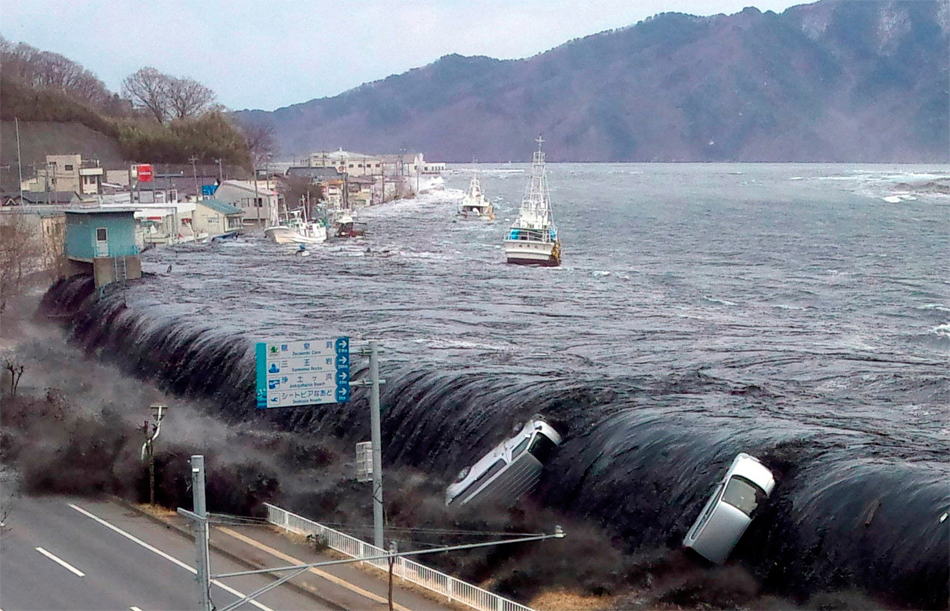
The 500 cubic kilometre landslide that we all missed – triggered by the Tohoku earthquake
The Tohoku Earthquake tsunami
The UK environment research council NERC has a press release out today about work that was presented last week at the AGU Fall meeting in relation to the Tohoku earthquake in Japan. There has been some investigation of the terrestrial landslides triggered by the event, but of course most of the interest has been focused on the tsunami. There has always been something of a mystery about the Tohoku earthquake tsunami, in part because it was so large and in part because its behaviour is a little strange. In particular, the tsunami had two distinct peaks some 20 to 30 minutes apart.
..
A giant submarine landslide
The press release reports on as yet unpublished research that investigated the tsunami using wave buoy data and modelling, demonstrating that the wave cannot be explained by the earthquake alone. This suggests a secondary source – most likely a submarine landslide – the potential location of which they tracked down using the wave buoy data. Dave Tappin of the BGS explains:
‘Using maps of the seabed [I assume this means sonar data], we identified a landslide that was 40 kilometres wide, 20 kilometres long and 2 kilometres thick. That makes it 500 cubic kilometres, so it’s pretty big.’
‘We then used computer models to simulate the tsunami from a dual source; the earthquake and the landslide, and this gave us the high water levels along the north Honshu coast.’
‘An additional check on the landslide source was from an analysis of the wave frequency at the buoys, which showed a high-frequency component that could only be from the landslide.’
This is of course an enormous landslide – the volume is impressive in itself, but a slide with a thickness of two kilometres is genuinely amazing. I am really looking forward to seeing the submarine imagery of this event. The Tohoku earthquake and tsunami killed about 16,000 people and left about 2,700 missing.
16 December 2013
The Rockville rockfall cliff has a history of dangerous collapses
More information about the background to the Rockville rockfall
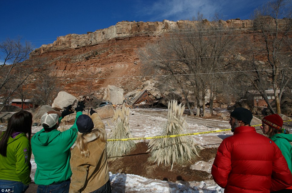
Over the weekend more information was released about the Rockville rockfall in Utah on Thursday, which killed two people. In some ways the most revealing information is summerised by the Salt Lake Tribune, which has a report about previous rockfalls on this set of bluffs. The report states that:
This is the sixth massive rockfall in the town of 251 since October 2001, when a sleeping resident narrowly escaped injury as a 300-ton boulder annihilated a third of his home. A year later, a car-sized boulder landed on Main Street. In spring 2007, a Main Street motorist collided with a fragment from a rockfall. And in November 2010, hundreds of rocks — the largest weighing 78 tons — crashed into the cliff base without hitting any property.
However, in February 2010 there was a very near miss, reporting that in February 2010 a 450 tonne block detached from the slope and fragmented. The report notes that:
Nobody was harmed, in large part thanks to a previously fallen boulder that it collided with at the base of the cliff. The biggest remaining fragment of the 450-ton rock was just 20 tons, but the pieces were moving fast enough that one rock crashed through one side of a washroom and out the other before damaging two vehicles.
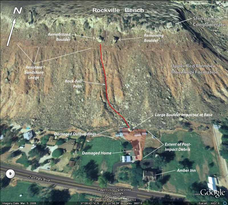
The Utah Geological Survey (UGS) report into the February 2010 event is available online. It includes some very good images of the aftermath of that rockfall, plus this annotated Google Earth image of the 2010 rockfall event:
http://geology.utah.gov/utahgeo/hazards/landslide/rockville0210/index.htm
..
Note that the house that was struck in the Rockville rockfall on Thursday is on the left side of the image. The UGS assessed the hazards associated with these cliffs in their report on the 2010 event (NB the document is a PDF). This is a very good review that I fully recommend you read. The key information in terms of future hazard is that the shadow angle (the angle from the top of the cliff that defines the maximum runout of the boulders) is 22 degrees. Thus, as the report states:
A 22° shadow angle from the base of the Shinarump cliff places many homes, roads, and other facilities in the northern part of Rockville within a high rock-fall-hazard area. Several structures south of the Virgin River on River Road (figure 2) may also be at risk from falling rock originating from the Shinarump-capped mesa to the south.
The report then makes a clear recommendation:
The UGS recommends further detailed investigation to evaluate the rock-fall hazard in Rockville; investigations should include a detailed assessment of potential sources (including bedrock and talus) and maximum runout distances (minimum shadow angle). Investigation results should include a map delineating areas susceptible to rock fall. Site-specific, rock-fall-hazard investigations should be performed by qualified geologic consultants for future development. Owners of existing homes within high rock-fall hazard areas should be informed of the hazard, and they may wish to retain a team of geologic and geotechnical consultants to investigate the risk from rock falls to their property and the feasibility of rock-fall risk-reduction measures.
The nature of the Rockville rockfall
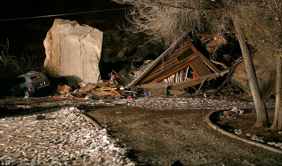
The rockfall on Thursday appears to have been a large first time failure on the Shinarump Conglomerate that caps the slope, judging by this image from the Daily Mail:
http://www.dailymail.co.uk/news/article-2523559/Pictured-The-couple-crushed-inside-home-Utah-rock-slide.html
..
The detachment site is visible just above the tree, and the path of the boulders (of which just one struck the house) down the slope is clear. There may have been some entrainment of debris at the toe of the slope. The boulder that destroyed the house did not travel the longest distance.
Comparing the Rockville rockfall hazard approach with that of Christchurch, New Zealand
Finally, it is interesting to contrast the approach that adopted to manage this known hazard with that being adopted by Christchurch City Council in New Zealand in managing the rockfall hazards in the Port Hills area and the associated CERA reponses after rockfalls triggered by the recent earthquake sequence (see my gallery of images from these events here, here, here and here). In the Christchurch case, the Council and CERA are taking a very proactive approach to manage the hazard, based on a state of the art assessment of the level of hazard.
13 December 2013
The Utah rockfall tragedy – the importance of interpreting clues in the landscape
The Utah rockfall event
In the ironically named Rockville in Utah, a rockfall last night crushed a house, killing the two inhabitants. The Utah rockfall was a hard rock slope failure on a large-scale. The image below (from the Daily Mail – who incidentally have an interesting view of the size of an elephant!) shows that this was a massive block:
http://www.dailymail.co.uk/news/article-2523067/Boulder-size-elephant-crushes-entire-house-instantly-kills-inhabitants-Utah-landslide.html
..
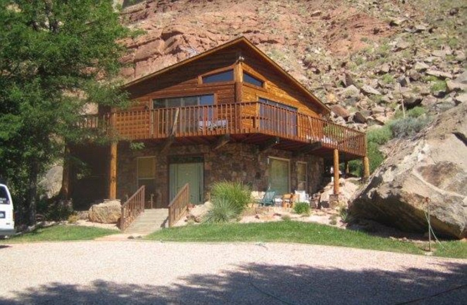
The same article also has a view of the house before the collapse:
http://www.dailymail.co.uk/news/article-2523067/Boulder-size-elephant-crushes-entire-house-instantly-kills-inhabitants-Utah-landslide.html
..
Implications of the Utah Rockfall for hazard assessment
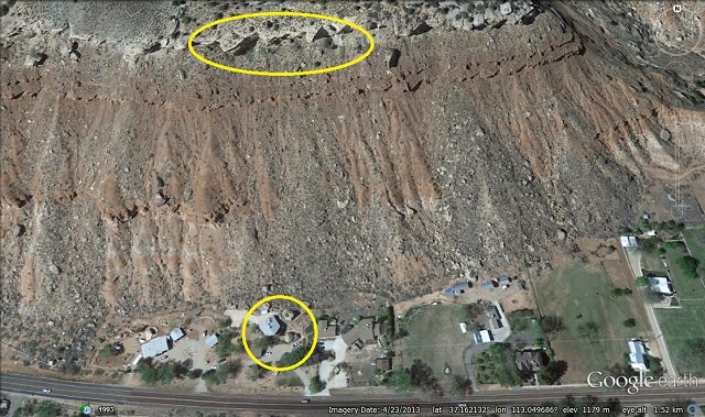
This tragedy does serve to illustrate a key point about rockfall hazard assessment, which is that debris from earlier events often gives a pretty good indication of the hazard. In allowing the selection of a site close to a rock cliff, a key first consideration should be the level of rockfall hazard, as indicated by boulders from previous events. the image below is from Google Earth, dated earlier this year. I have highlighted at the crest of the slope potentially unstable blocks of rock, and at the toe the house that the boulder struck:
 ..
..
A zoom into the area around the house shows that it was surrounded by very large boulders – these are of course the debris from previous very large rock slope collapses (and one of them is very clear in the photograph of the house above):

..
The presence of these boulders should have been at least an initial flag that this was a potentially dangerous location. Coupled with the structure at the top of the slope, the situation looks still worse.
An interesting challenge to the authorities in the aftermath of the Utah rockfall tragedy will be assessing the safety of the remaining houses at the foot of the slope.
Killing off the Canary Islands landslide megatsunami scare
![]()
For those of us working on and researching natural hazards, one topic repeatedly comes up at social events. The conversation usually goes like this:
New Acquaintance: “So what do you do?”
Me: “I research natural hazards, and in particular landslides”
NA: “Oh – is it true that one of the Canary Islands volcanoes is going to collapse in a giant landslide? I was told that it’ll cause a tsunami that’ll devastate the coasts of Europe and America”
Me: “Excuse me – I’m just going to bang my head on the table…” [thump!]
The question of course refers to a scare a few years ago, based on a peer-reviewed paper, that a flank collapse of Cumbre Vieja volcano on the island of La Palma in the Canary Islands could collapse, generating a megatsunami that would initially be about 1,000 metres high, and would still be about 50 metres high when it reached for example the eastern seaboard of the USA (Wikipedia has quite a nice article on megatsunamis if you are interested). It is fair to say that in my experience there is agreement that such a flank collapse could occur (and there is lots of evidence that such events have happened in the past), but the level of support for the megatsunami hypothesis is, shall we say, somewhat lacking within the scientific community. There is a nice evaluation of the work by Dr George Pararas-Carayannis, which concludes that:
“The threat of mega tsunami generation from collapses of oceanic island stratovolcanoes has been greatly overstated. No mega tsunamis can be expected”
A key issue here is the mechanics of the landslide. To generate a very large tsunami, this slide would have to happen very fast and as an essentially coherent block. Remember that this is a landslide of 500 cubic kilometres – we do not think that very, very large landslides usually behave like this. The chances are that a collapse would occur in stages over a longer time period, which would generate a much smaller wave. Most scientists recognise that the single, intact block collapsing very fast idea is theoretically possible, but that it is the extreme end-member of a wide range of scenarios, and thus is highly unlikely. There are other issues too (like where are the tsunami deposits from other megatsunamis given that we know that previous collapses have occurred? A tsunami on this scale should leave deposits that would be very easy to map). Unfortunately, although most landslide scientists view the likelihood of a single coherent landslide as being very low, the actual evidence to support that view in the case of these types of landslides has not been strong..
Unfortunately, despite these rebuttals the story has had remarkable traction. Take this page on Virgin Media for example, which has this wonderful (?) image:
http://www.virginmedia.com/science-nature/natural-world/natural-disasters-waiting-to-happen.php
And text that says:
“A colossal wave caused by a chunk of rock the size of the Isle of Man breaking off La Palma in the Canary Islands, will one day devastate Southern Europe and the entire East coast of America. Scientists believe this disaster is already way overdue. When it does come, it will cause a mega tsunami that will hit with the power of an atomic bomb travelling at the speed of a jumbo jet. Starting off at 2000ft, the giant wave will still be 150ft high by the time it reaches the other side of the Atlantic, destroying everything in its wake and affecting up to 100 million people.”
Given the ridiculousness of this sort of statement (and there are worse examples out there), it is good to see a new paper that erodes the case for the megatsunami still further. This paper, Hunt et al. (2013) has just been published in the journal Geochemistry, Geophysics, Geosystems (sadly the article is behind a paywall). The paper presents a very detailed analysis of the deposits left on the sea floor by Canary Island flank collapses. The research is meticulous and comprehensive. The authors note that the sea floor deposits record eight volcanic flank collapse events, the largest of which was about 350 cubic kilometres. However, the key element is that each deposit is formed from a series of subunits, each of which can be clearly differentiated from other subunits based on the geochemistry of the materials that they contain. So, the interpretation by the authors, which sounds very sensible to me, is that each subunit represents a different phase of the collapse event. In other words, each of these major collapses did not occur as a single, coherent block, but as a series of sections one after the other. If you want an analogy, then what better example than the famous 1993 Pantai Remis landslide in Malaysia:
The implications are clear. Previous flank collapses have occurred as a series of distinct events rather than as a single coherent block. Each of these could have been able to generate a very large wave, and even a local tsunami. However, they would not have generated a megatsunami. There is no reason to believe that a future event will behave differently, so this scare should be consigned to the garbage can once and for all.
Reference
J.E. Hunt, R.B. Wynn, P.J. Talling, & D.G. Masson (2013). Multistage collapse of eight western Canary Island landslides in the last 1.5 Ma: Sedimentological and geochemical evidence from subunits in submarine flow deposits Geochemistry, Geophysics, Geosystems, 14 (7), 2159-2181 DOI: 10.1002/ggge.20138
11 December 2013
Live blogging – the AGU bloggers forum
It seems sensible to live blog the blogging forum. The audience is quite large – the room is about 2/3rds full I guess a show of hands suggests that the audience is about 50% existing bloggers and 50% those who might want to blog in the future. I’m not going to give a step-by-step description of the session, just highlight the most interesting points. The panel is Jessica Ball and Austin Elliott, both of whom are existing AGU bloggers, and Laura Guertin, who is “being courted” by the AGU blog network. The master of ceremonies is Larry O’Hanlon, who manages the AGU blog network.
Laura Guertin impressively runs two blogs (how can she manage that!). One is aimed at informing her own students about her activities outside the classroom. The second is a teaching with technology blog. She is emphasising the key role of Twitter – I can only agree, but was far too late to the twitter thing. Twitter is a key way to raise the profile of both the blog and of individual posts.
Larry rather kindly described my own experiences of blogging, and in particular the way that it has raised my own profile. This is undoubtedly true – almost everyone I meet here mentions this blog – so it justifies the time I have to commit to it. Jess Ball talked about the role that it has played for her – she is now moving to a one year post as a policy fellow at GSA, so I guess blogging has been quite instrumental in terms of developing her career direction.
One member of the audience highlighted his own blog – called bogology – great title! It’s on peatlands in case you were wondering… And now someone is talking about a blog called the Rock Crusher, which highlights what happens to field samples back in the lab.
There is some discussion about the length of posts – the key point being that they don’t need to be very long. But others disagree interestingly Gavin from Real Climate made this point- the key is that you need to find your blog voice – some blog posts need to be long in order to explain context or to provide a new perspective. The key is to have something to say, and to then write a post to say it. If you have nothing to say, don’t say it. A key may be to review continuously review what you are providing and what your audience wanted. One blogger in the audience eve runs focus groups. Very impressive!
The discussion is getting a bit metaphysical now! There is some discussion about what a blog actually is – some things that are called blogs may well not really be blogs – perhaps they are just “news light” journalism.
There is also some discussion about how to grow your audience – tags, keywords (especially food!), twitter are all key. This issue was raised by the author of the Social Mathematics blog – actually a very cool and interesting blog that deserves a wide readership.
Issues of plagiarism have cropped up – this does happen and can be a big issue, though it hasn’t been a problem for me. The key is to be clear about copyright and to challenge the perpetrators when it happens. It does seem to be a good reason not to pre-publish your research on your blog before it comes out in a paper though. There has also been some discussion about correcting posts that are factually incorrect. Personally I think this is vital, but it is sensible to flag when you have made major changes.
An audience member asked about how to get comments on your blog. I have never managed to get lots of comments on my blog (shame really – that’s a hint by the way!), but interestingly no-one else seems to know how to either (one suggestion is to make deliberate minor errors to prod people to interact – I’m not sure I want to go that far!). An alternative approach is when you get deluged with trivial or even mendacious comments – Real Climate has an open threat to deal with off topic stuff and an other thread (called the borehole) into which the real drivel is put.
Now closing – it was an excellent session.
AGU Fall Meeting 2013: the first two days
Two days into the AGU Fall meeting and I feel exhausted already! As usual it is a modern day equivalent of the biathlon, consisting of mad dashes between sessions (carefully arranged to be the maximum distance apart) followed by a need to concentrate intensely for something between 15 minutes and two hours.
it is had to identify the highlights s there has been so much good stuff. I should wave the flag for my team first – in particular a paper by Nick Rosser (on which I was a minor co-author) on the long term monitoring that we have been undertaking on the cliffs of North Yorkshire. This is a ten year (and counting) project with an amazing dataset, beautifully presented by Nick. In the same session Colin stark presented his work on characterising giant landslides using the global earthquake network. This is research that never ceases to impress, and it is allowing an understanding of the magitude-frequency relationships of these big slides. The verdict – they occur far more often than we realised, and events that we would have mapped as a single landslide from the deposit are often a series of events in reality. Speaking of which, Runqiu Huang presented work from Chengdu University of Technology on the giant landslides from the Wenhuan earthquake, including the largest slide in the last three decades at Daguangbao (>1.2 cubic kilometres!). The most interesting aspect of this work was a new model for large seismically triggered landslides, which suggests that they tend to have a steeped rear scarp and a lower angled sliding surface at the toe, forming chair shape, when compared with hydrologically triggered slides. That is an interesting idea that deserves further attention.
Jonathan Godt of the USGS presented some work that they have been doing on the landslides triggered by the extreme rainfall event in Colorado this summer, in which there were three fatalities from landslides. I will try to track down some images of the landslides, but in the meantime there is a very interesting paper about them here (NB pdf). In the poster session today Kerry Leith and colleagues presented a fascinating model on the evolution of landscapes during and between glaciations, and the way that the resultant stress state controls the processes that occur after the first ice age. I won’t say more here as the team deserves to present this material for themselves, but the ramifications in terms of our understanding of mountains are profound.
Away from landslides, James Elsner presented a fascinating paper that explored whether tornadoes in the US are becoming more energetic, a vastly complex topic. To do so required a very detailed and complex re-analysis of the underlying tornado dataset – this was very rigorous and impressive (but no doubt the climate skeptics will wrongly misinterpret this as being some sort of fudge). Th resulting data suggests that US tornado energy dissipation has increased dramatically in recent years. Elsner did not want to link that to climate change – sensibly – but the trend in itself is deeply alarming.
There is so much good work that I haven’t been able to mention – the quality is incredibly high from start to finish. And of course the meeting rolls on – this afternoon to the bloggers forum (where my AGU blogging colleagues are on the panel) and then this evening to the Natural Hazards reception. My papers are tomorrow and on Thursday, so for me the real action is yet to come.
5 December 2013
An interesting landslide at Montescaglioso in Southern Italy
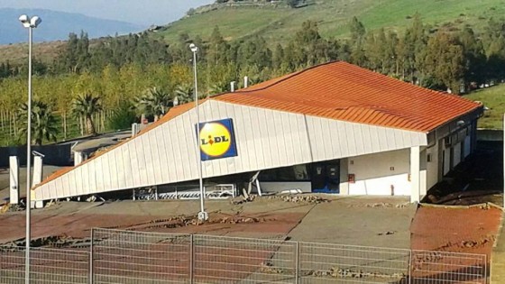
http://www.repubblica.it/cronaca/2013/12/04/news/maltempo_crolla_un_supermercato_a_matera-72654782/#gallery-slider=72666956
..
Reports are coming in a large landslide yesterday at the town of Montescaglioso in Basilicata in Southern Italy. The BBC for example has this report, there is a nice gallery of images here, and there are a few videos of it as well:
The reports suggest that it occurred after a period of heavy rainfall. The slide appears to have caused extensive damage, including the collapse of a supermarket, but it has not caused any loss of life.
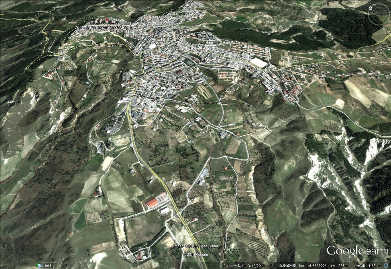
This is the area affected by the landslide as per Google Earth. The landslide is in the foreground – the large red-roofed building is the Lidl supermarket that has been destroyed, as per the screenshot at the top of this post:
 ..
..
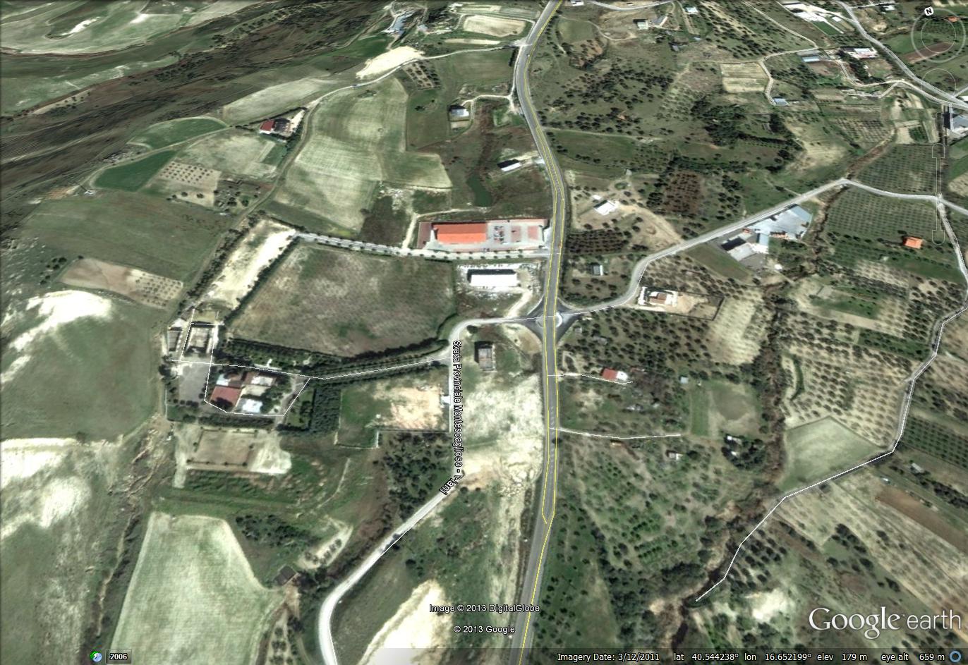
Note that there is no shortage of pre-existing landslides in the above image – this is clearly a very landslide-prone area. The landslide itself appears to have affected this part of the town:
 ..
..
Interestingly, this area is known to be affected by a large mass movement, which is known as the “Madonna La Nova” landslide. There is a poster here (NB pdf) that described remote sensing work that has been undertaken on it, and there is at least one published paper that describes it (but which I cannot access because it is behind a paywall). My very initial interpretation would be that this is the boundary of the major landslide complex (and note that the historic town has not been built in this area):
 ..
..
I have also highlighted the location of the supermarket. An interesting question to ponder is why the supermarket was built at this location, given that the historic town appears to have avoided the landslide-affected area.
4 December 2013
Landslides in Art Part 20: A cannonade on the Matterhorn 1862
This is part 20 of the occasional Landslides in Art series. Part 19 is here.
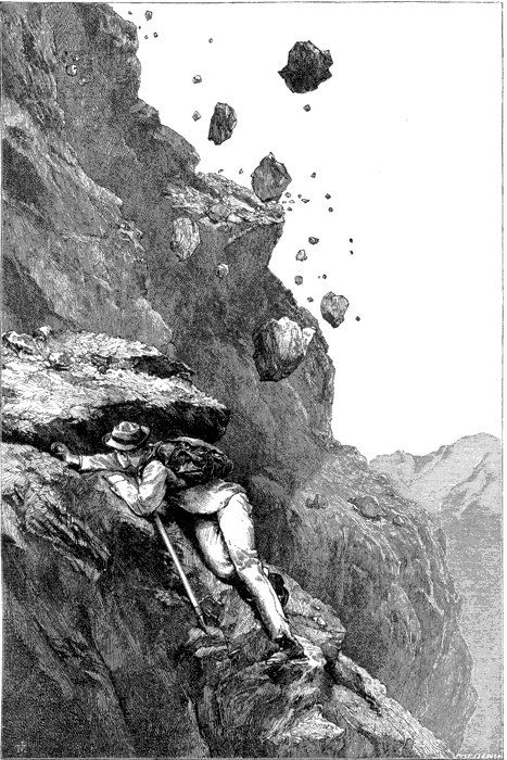
The piece I have chosen today is A Cannonade on the Matterhorn, 1862, by Edward Whymper (1840-1911). Whymper was an English mountaineer and author whose crowning glory was to be the first person to successfully climb the Matterhorn. The successful climb was completed on 14 July 1865 as a party of seven. Whymper had already made nine unsuccessful attempts. Unfortunately, on the way back down an inexperienced member of the climbing party, Douglas Hadow, slipped and fell to his death, dragging two others, who also died, with him.
Whymper was also an engraver of illustrations, primarily for books and periodicals. Whymper published an account of the climb, and of his many unsuccessful attempts, from which the engraving is taken. The book, which of course is now out of copyright, is available online in various formats. There is even an online version. The rockfall in the engraving occurred in 1862, and thus was during one of his unsuccessful attempts.
The rockfall in the image is described as follows:
I was near to [the tent] when all at once I heard a noise aloft, and, on looking up, perceived a stone of at least a foot cube flying straight at my head. I ducked, and scrambled under the lee side of a friendly rock, while the stone went by with a loud buzz. It was the advanced guard of a perfect storm of stones, which descended with infernal clatter down the very edge of the ridge, leaving a trail of dust behind, with a strong
smell of sulphur, that told who had sent them. The men below were on the look-out, but the stones did not come near them, and breaking away on one side went down to the Glacier du Lion.
The rockfall was also observed by Professor Tyndall, and the book includes an account of the rockfall as follows:
We had gathered up our traps, and bent to the work before us, when suddenly an explosion occurred overhead. We looked aloft and saw in mid-air a solid shot from the Matterhorn describing its proper parabola, and finally splitting into fragments as it smote one of the rocky towers in front. Down the shattered fragments came like a kind of spray, slightly wide of us, but still near enough to compel a sharp look-out. Two or three such explosions occurred, but we chose the back fin of the mountain for our track, and from this the falling stones were speedily deflected right or left.”
It is even possible to buy a t-shirt, a cushion, a bag or even an iPad sleeve featuring this image.
2 December 2013
Twitter: 1000 followers
Yesterday I reached 1000 followers on Twitter on my account @davepetley. That feels like some sort of a milestone, so just a brief note to say thanks to everyone who follows me.
 Dave Petley is the Vice-Chancellor of the University of Hull in the United Kingdom. His blog provides commentary and analysis of landslide events occurring worldwide, including the landslides themselves, latest research, and conferences and meetings.
Recent Comments