

20 May 2016
The GFDRR ThinkHazard! tool
The GFDRR ThinkHazard! tool
Yesterday the new GFDRR ThinkHazard tool was launched. This is a new web based system for developing countries that allows a basic assessment of hazard across a range of perils on a geographical basis. The GFDRR description is as follows:
The Global Facility for Disaster Reduction and Recovery (GFDRR) has created a new online tool for the development community, which enables non-experts to consider natural hazard information in project design. ThinkHazard! has been developed by GFDRR’s Innovation Lab, in collaboration with BRGM (the French geological survey), Camptocamp, and Deltares. Many other organizations and individuals have contributed data sets and expert input into information provided in the tool.
ThinkHazard! is a simple and quick, yet robust, analytical tool that enables a development specialist to determine for a given project location, the potential likelihood of eight natural hazards, and what actions they should take to make their project resilient. The tool analyzes hazard under current climate but also provides guidance from IPCC on how climate change may affect hazard frequency and intensity into the future.
This is the range of hazards that the tool covers:

ThinkHazard! perils
I made a minor contribution to this project by writing the recommendations for the landslide part of the tool, and by benchmarking the results against the global landslide database that Melanie and I manage.
This is an example of the hazard maps that the tool can generate:
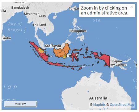
An example of a Thinkhazard! map, in this case for Indonesia
.
High hazard in this case is in red, etc. However, the tool does allow a higher level of detail, down to the district level. This is a district level map for Nepal for example:
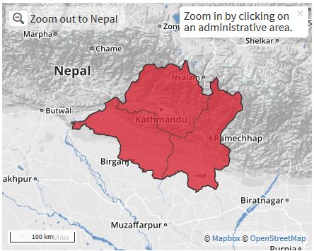
ThinkHazard! map for landslide hazard at the district level in Central Nepal
.
For each level of hazard there are a set of recommendations as to how to go about determining the level of threat and to manage it. My sense is that this is an incredibly useful tool to both raise awareness of the likelihood of natural hazards in poor countries and to provide mechanisms to their mitigation. It is an impressive achievement.
19 May 2016
The Aranayake landslide in Sri Lanka
The Aranayake landslide in Sri Lanka
Aranayake landslide in Sri Lanka is now thought to have killed about 140 people, from which the remains of 19 victims have been recovered to date. The landslide was triggered by exceptional rainfall associated with a slow moving tropical cyclone. Some reports suggest more than 350 mm may have fallen. The best overview image of the landslide that I have seen to date is this one, by AP and posted on the BBC website:
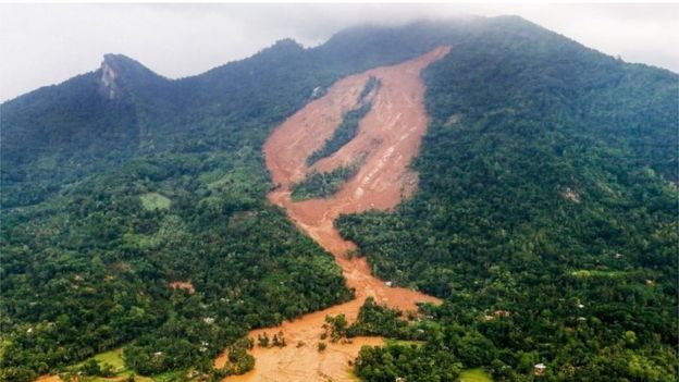
The Aranayake landslide in Sri Lanka via the BBC and AP
.
This is a complex landslide. It appears to have started as a small landslide high on the hillslope – is there a hint of bedrock in that area? I suspect so, which might suggest regolith sliding on a bedrock interface. That then appears to have induced a much more substantial failure on the steeper sections downslope, with three main portions. There is certainly bedrock evident in this area, but the mobile material appears to be deeply weathered soil / regolith. Finally, the displaced material appears to have turned into a highly mobile flow that has channelised. It is this portion of the landslide that is likely to have caused the loss of life. I would also note from this image that the underlying geological structure here might be highly complex – note the different inclinations of the rock surface visible on the ridge to the left compared with the bedrock visible in the slide itself. This suggests that there could be a structural element to this as well, perhaps.
More detail is available about the sliding surface in this image, which was tweeted by the Sri Lanka Red Cross yesterday:
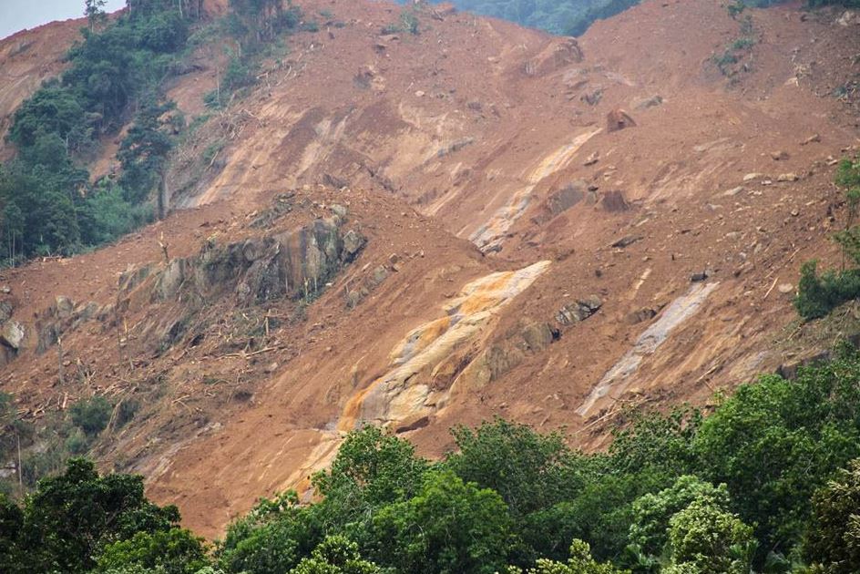
The Sliding surface of the Aranayake landslide, via the Sri Lanka Red Cross
.
In this image it is clear that the main landslide on the steeper slopes consisted of regolith sliding on a bedrock interface. The Sri Lanka Red Cross have also tweeted this helicopter image of the lower portion of the landslide, which illustrates the highly mobile nature of the mass movement:
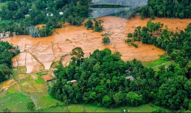
Sri Lanka Red Cross image of the lower portion of the Aranayake landslide
.
Reports today suggest that rescue operations have been suspended today due to further landslide movement associated with heavy rainfall. This will be a very dangerous site until the weather clears up and the ground dries out. The monsoon is not far away.
I believe that this Google Earth image shows the location of the landslide:
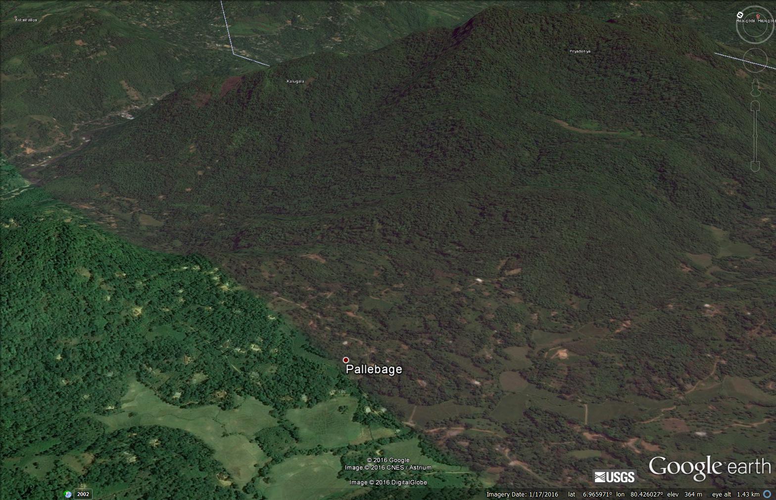
Google Earth image of the Aranayake landslide in Sri Lanka
.
Pallebage (location: 6.9639, 80.4209) is reported to be one of the communities destroyed by the landslide. However, so far I have been unable to pin the location down more precisely. Viewing the Google Earth image from directly above leaves me with a suspicion that this might not have been the first major landslide on this hillside. I have indicated the location of a possible large, much older landslide:
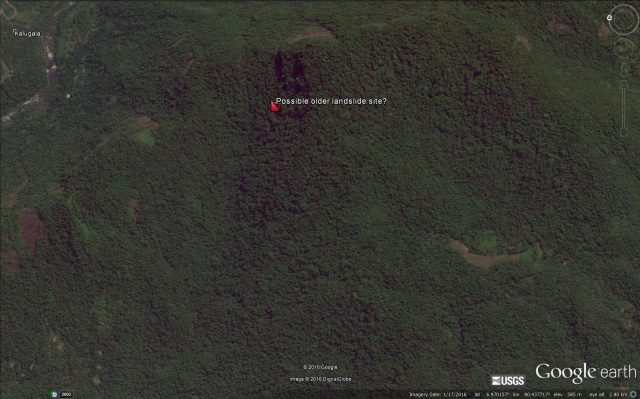
Google Earth image of a possible older landslide site close to the Aranayake landslide location
.
18 May 2016
Fatal landslides in 2016 so far
Fatal landslides in 2016 so far
As the rainy season starts to loom in the global landslide hotspots of South and South-East Asia, this is a good time to review the global pattern of fatal landslides in 2016 to date. This is data that I have been collecting since 2002 – I wrote it up in a paper (Petley 2016) a few years ago – see the blog posts of the time – and Melanie and I are currently working on an update (watch this space).
So, lets take a look at fatal landslides in 2016 so far. As of yesterday I had recorded 111 landslides that caused loss of life, not including those triggered by earthquakes (does anyone have a full list of fatal landslides from the Japan earthquake last month?). These landslides killed a total of 620 people. This is how the cumulative landslide graph looks, correct to 15th May 2016:
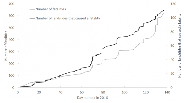
Cumulative graph of landslide fatalities in 2016
.
This shows a quite normal pattern, with a comparatively slow but steady start to the year, accelerating as time proceeds. As we now come into the northern hemisphere rainy season, the event rate is increasing. This is more dramatic in late June.
This is the same data plotted together with 2015:
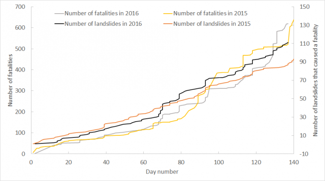
Cumulative graph of landslide fatalities in 2016 together with data from 2015
.
In spite of the El Nino event, which is commonly thought to increase landslide occurrence, 2016 looks to be very similar to 2015 in most respects. The number of landslides is a little higher, but not significantly so. However, most of the global losses for 2016 have yet to occur. This is the full dataset for 2015 and 2016 to date:
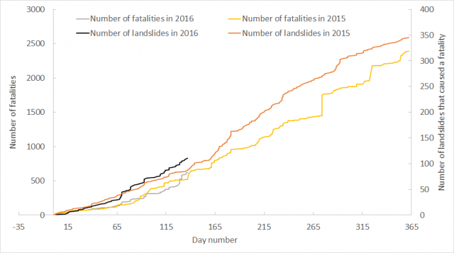
Cumulative graph of fatal landslides in 2016 together with the full dataset for 2015
.
The 2015 landslide season in South and East Asia was not strong, which dominates the global pattern. Forecasts for the monsoon suggest that this year might be somewhat worse.
For the first time I have decided to publish the underlying data online (this should open as an Excel spreadsheet). I have started with my data for 2016 so far. You can use this for your own purposes, although I would be grateful if you would:
- Acknowledge the source of the data;
- Cite the paper that describes the dataset – Petley (2012) – see full reference below. This work is described in a blog post from 2012.
- Let me know how you have used it by emailing me directly.
I’d also be glad to know of any errors and omissions. I should note that this data is preliminary at this point – I haven’t done the detailed checking as yet – and I haven’t yet undertaken the geolocation work to allow the landslides to be mapped.
Reference
Petley, D.N. 2012. Global patterns of loss of life from landslides. Geology 40 (10), 927-930.
16 May 2016
New videos for Monday morning: an earth mover get caught in a landslide and a debris flow from the Himalayas
A new landslide video for Monday morning: a destroyed earthmover
To get the week going, this video has popped up on Youtube. It shows an earthmover getting caught, and probably destroyed, in a landslide. I don’t think I have seen it before:
.
Just before the landslide catches the earthmover gets struck the jib is moving, suggesting that the cab was occupied at this time of the landslide. There is no information in the video as to whether the operator survived the accident:
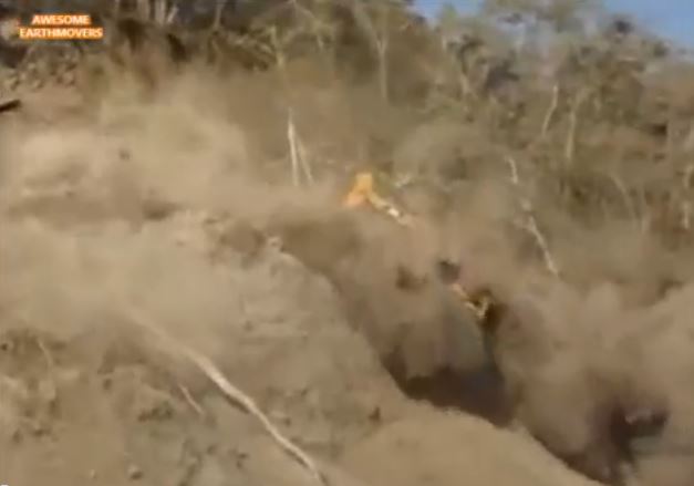
The backhoe being struck by a landslide, via Youtube
.
And a spectacular debris flow from the Himalayas
This one was published on Youtube last month – thanks to Dr Phil Collins of Brunel (@PhilCollins_UK) for highlighting this one via Twitter. There is no information as to the location:
.
It is a beautiful example of the way in which a debris flow can transport enormous boulders:
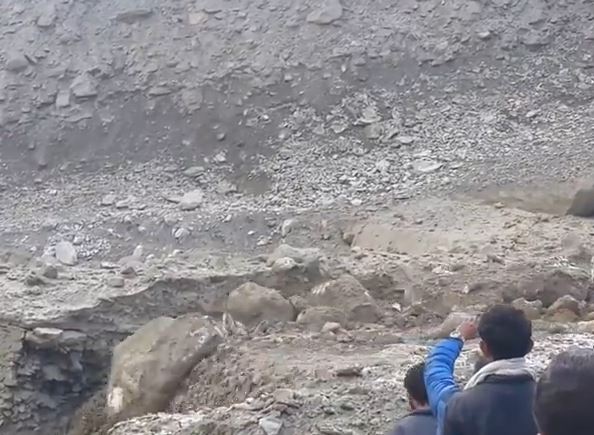
A debris flow transporting large boulders in the Himalayas, via Youtube
13 May 2016
New landslide videos from the last few days, including an impressive rockfall at Mont Granier
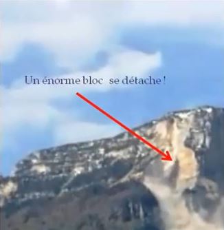
Mont Granier rockfall via Youtube
.
A large rockfall on Mont Granier
Mont Granier is located in the Chartreuse Mountains of the French Prealps. This was the site of an enormous landslide in 1248 that may have killed over a thousand people. In early January 2016 there was another substantial rock slope collapse on Mont Granier, and there has been at least one other event this year. Earlier this week, on 7th May, a further rockfall occurred, comprising a collapse of a limestone pillar. This event was captured on a good video that is now on Youtube:
.
The site of this rockfall is captured rather nicely in this video of the rockmass:
.
Not unusually, the rock mass is continuing to generate small scale rockfall activity:
.
Le Dauphine has some nice images and a write-up (in French) of this event (along with some very irritating adverts). They suggest that this rockfall was similar in scale to the event of January 2016, with a volume of about 50,000 cubic metres, although other reports suggest that the event in January was much larger, with a volume of about 170,000 cubic metres.
A landslide at Swimmer’s Delight in Humboldt County, California
A less spectacular, but nonetheless interesting landslide was also captured at Swimmer’s Delight in Van Duzen County Park, Humboldt County in California last week. The Lost Coast Outpost has a nice write up of this event:
A tower of rock and earth crashed into the Van Duzen River at one of Humboldt County’s most popular swimming holes last week. A group of locals were able to capture the moment on their smartphones as they ate lunch on the riverbank of Swimmer’s Delight at Van Duzen County Park in Fortuna last Monday.
The video is quite neat, especially the final, somewhat dynamic, event:
.
I was relieved to see that none of the drinks were spilled.
11 May 2016
Large landslides in Africa in the last few days
Large landslides in Africa in the last few days
I surprisingly rarely see reports of major landslides in Africa. However, in the last few days there have been three major rainfall induced events across the continent:
1. Rwanda
Over the weekend heavy rainfall in Rwanda triggered landslides and floods across four districts of Rwanda. Most seriously hit was Gakenke district in the north of the country, which suffered 34 fatalities in landslides. Elsewhere there were another 25 deaths. All Africa reports that 67 people have died in Rwanda in landslides this year to date. This image shows one of the landslides this week:
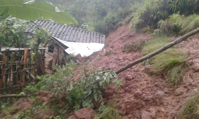
Landslides in Africa: one of the landslides in Uganda this week, via Kigali Today
2. Uganda
Meanwhile, a major landslide struck Kyamukube village in Bukonzo sub county, Bughendera County in Uganda yesterday. Reports suggest that to date 12 bodies have been recovered, but some reports suggest that “scores more are missing”.
3. Ethiopia
Our landslide model suggests that Ethiopia should suffer many fatal landslides, but I record few. However, yesterday there was a major event, again induced by rainfall. The largest impact seems to have been at Wolayita in the south of the country, where 41 people are reported to have died in a single landslide. Press TV suggests that rainfall in Ethiopia is very anomalous this year, and suggests that El Nino may be a cause.
10 May 2016
The location of the Chitan hydropower landslide
The location of the Chitan hydropower landslide
Xinhua now reports that the number of people killed or missing in the Chitan Hydropower landslide on Sunday total 41 people, and that so far 31 bodies have been recovered. A further 13 people were injured, some critically. CCTV has put on Youtube a section of drone footage of the landslide site, showing the ongoing rescue operations:
.
This view suggests that the Chitan hydropower landslide was probably a channelised debris flow:
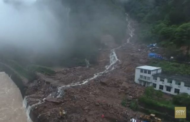
A still from drone footage of the aftermath of the Chitan hydropower landslide, via CCTV and Youtube
.
The gully down which the debris flow has travelled is clear. Whilst on first inspection it might be hard to believe that this gully could generate such a devastating landslide, a view of the famous Lantau Island debris flow video from Hong Kong in 2008 is a good reminder of what is possible:-
.
Based on the drone footage I have been able to track down the location of the Chitan Hydropower landslide on Google Earth. The location 26.713 N, 117.124 E, as shown in this image:
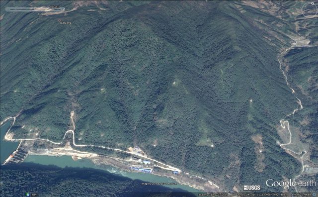
Google Earth imagery from February 2016 of the location of the Chitan Hydropower landslide
.
It is clear that the buildings were constructed at the mouth of a narrow gully that drains a reasonable-sized natural terrain catchment. This is steep terrain – this Panoramio image shows the hydropower infrastructure, and forested slopes, just upstream of the landslide site:-
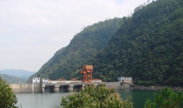
The nature of the terrain in the area of the Chitan hydropower landslide, via Panoramio
.
The damage inflicted by the debris flow can be deduced by comparing the Google Earth imagery below with the drone footage above:-
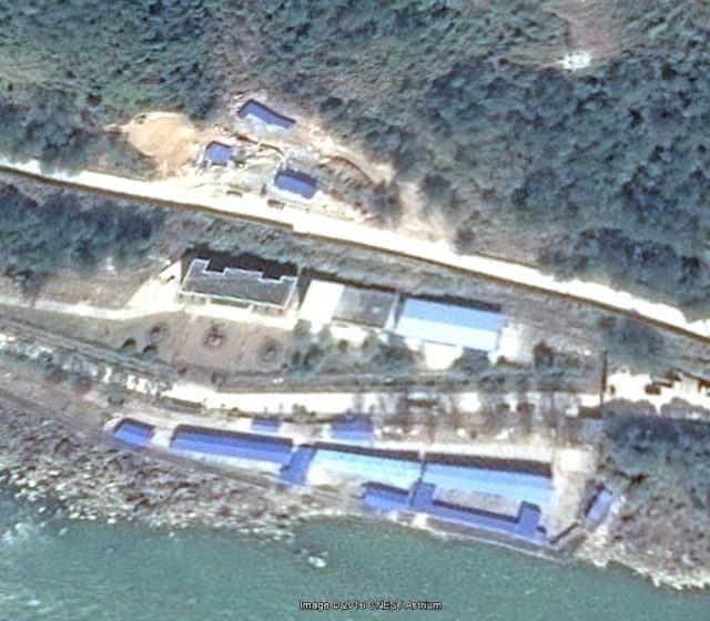
Google Earth imagery from 2016 of the buildings struck by the Chitan hydropower landslide
.
The building in the centre of the image, with the white roof section on the left side and grey on the right, is still intact in the imagery. The building to its left, with the dark grey roof, has been completely destroyed. Of the buildings on the river frontage, the light blue structure appears to be intact, those to the left have been destroyed. I would hazard a guess that these are the dormitories, whilst the missing building with the dark grey roof is the headquarters building. The smaller structures on the other side of the road are also missing.
Once again this appears to be a case of poor understanding of the dynamics of this landscape. Locating structures so close to a debris flow gully was not wise. I continue to worry that the mounting toll of landslides associated with hydroelectric schemes in China and India indicates that the hazards posed by these processes are not being adequately considered. I fear we may see a much larger accident in due course.
8 May 2016
Mining in Burma and hydroelectric power in China: two major landslides with familiar causes this weekend
Mining in Burma and hydroelectric power in China: two major landslides with familiar causes
Regrettably over the course of this weekend we have seen two landslides that follow familiar patterns, one associated with mining in Burma (Myanmar) and one with the construction of facilities for generating hydroelectric power in China:
1. Another jade mining landslide in Burma
It has been widely reported that on Friday there was yet another substantial landslide in the Hpakant jade mining area of Burma. Eleven Myanmar carries a local report with an image:
Thirteen jade scavengers have been killed and four injured on May 5 by a midnight landslide that hit a mining site run by the “111 Gems Company” in Seikmu village tract, Hpakant, Kachin State. Rescue workers used backhoes to dig out 13 bodies, saying that two of them were still unidentified. Hpakant Township police announced the names. “Normally the jade scavengers are not allowed into the site but sometimes the company works during the day and scavengers come at night, hunting for jade. It’s too dangerous work,” said police officer Myint Swe.
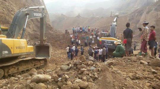
The aftermath of the jade mining landslide in Burma, via Eleven Myanmar
.
This is yet another in a sequence of mining-related landslides in Hpakant in the last two years, with brutal outcomes (see my blog post about jade mine landslides in 2015). The high level of landslides appears to be associated with very dangerous mining practices that reportedly have resulted from an increase in jade excavation, driven by profiteering ahead of the formation of the democratically-elected government. There is an urgent need to start to impose good practise on these operation to reduce the toll. It is of course likely that on top of the major, internationally reported landslides there are large numbers of smaller landslides that kill a few people but go unreported.
Another deadly landslide during the development of facilities to generate hydroelectric power in China
Another long running theme on this blog has been the unacceptably high level of landslides associated with the development of hydroelectric power in China and India. This was the subject of the paper that I presented at the Vajont conference in 2013; sadly the pattern has continued since. Xinhua has a story about the most recent major landslide, in Taining County, Sanming City in Fujian Province. Initial reports suggested 35 people were killed, this has now been reduced to 34. Xinhua reports the landslide as follows:
The landslide occurred at about 5 a.m. in Taining county, where about 100,000 cubic meters of mud and rocks flowed downhill, burying the construction site of a hydropower station and its office building… The landslide was triggered by heavy downpours that lashed down 191.6 millimeters of rainwater in 24 hours from Saturday.
A more recent story indicated interest in this event from both the Chinese President (Xi Jinping) and the Premier (Li Keqiang), and suggested that:
Xi also urged strengthening local monitoring and safety checks for hidden dangers to prevent secondary disasters.
I agree with this sentiment, but this has been stated many times previously to little obvious effect. The one image of the site that has been released to date gives a pretty horrific indication of the impact of the landslide on the camp:
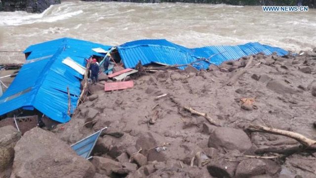
The aftermath of the landslide at Taining County, Fujian on Sunday, via Xinhua
.
4 May 2016
3rd North American Symposium on Landslides (NASL) 2017
3rd North American Symposium on Landslides
3rd North American Symposium on Landslides (NASL) 2017
From 4th to 8th June 2017 the Association of Environmental and Engineering Geologists and the Canadian Geotechnical Society will be hosting the 3rd North American Symposium on Landslides in Roanoke, Virginia, entitled
Landslides:
Putting Experience, Knowledge and Emerging Technologies into Practice

.
According to the website:
The main objective of the symposia is to provide a stimulating forum for geoscientists, engineers, planners, economists, program managers, and other decision makers concerned with landslide hazards and their impact on society. Papers related to investigation, classification, monitoring, analysis and mitigation of landslides, as well as case studies on innovative analysis techniques and solutions will be presented.
Abstracts are due on 30th June 2016, and full manuscripts on 31st October 2016. The technical programme will include:-
- Sunday Workshops
- Sunday Evening “Ice-Breaker” Reception
- Three days of Technical Presentations with morning Plenary Sessions and afternoon Concurrent Sessions
- Exhibition Space
- Lunch and Refreshment Breaks included
- Selection of Full-day Field Trips on Wednesday
- Poster Sessions
- Electronic Proceedings
This is a great series of meetings that brings together both researchers and practitioners. I thoroughly recommend it.
2 May 2016
The location of the Kyrgyzstan loess landslide, as caught on that amazing video
The location of the Kyrgyzstan loess landslide
The mainstream media has not really caught up with the Kyrgyzstan loess landslide as yet (it is only a matter of time I suspect – it has to be worth a shock-horror headlline in the Daily Mail, surely?), although a news report is now available on the Cihan website. Sadly it provides no additional information. As a reminder this is the video:
.
The original text on Youtube described the location as follows:
“Uch-Chat Pasture located nearby the village of Almaluu-Bulak in Jalal-Abad region”
Google Maps locates Almaluu-Bulak at 41.144 N, 73.022 W. On that basis I think the most likely location is shown in the Google Earth image below:
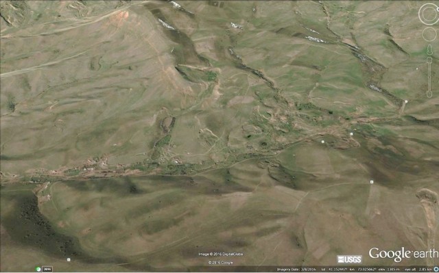
Kyrgyzstan loess landslide location, via Google Earth
.
The valley that best seems to fit the video is this one, also from Google Earth:
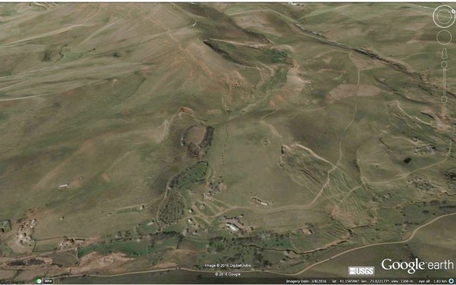
The valley that possibly generated the Kyrgyzstan loess landslide, via Google Earth
.
If so I believe that this would be the slope that generated the landslide. Note the small slip in the lower part of the slope, and the other adjacent landslides (of which more below):
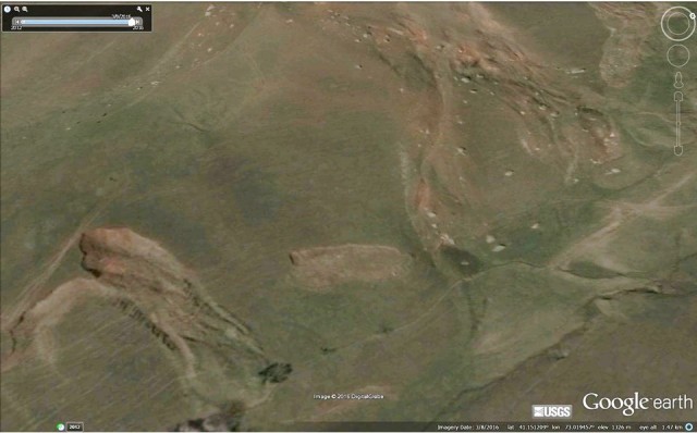
The slope that may have generated the Kyrgyzstan loess landslide, via Google Earth
.
This little corner of Kyrgyzstan has an extraordinary range of landslides. This is a Google Earth image of the wider area. The valley containing the most recent landslide is in the upper left corner of the image:
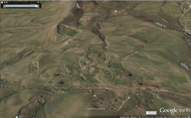
The area around the Kyrgyzstan loess landslide, via Google Earth. Note the extraordinary range of landslides in this area
.
Whilst some of these landslides seem to have had a high level of mobility, they do not appear to have been as mobile as the one last week. In the next valley over lies the set of landslides shown below. The one in the centre of the image has also shown a very high level of mobility. Note the house built right in the middle of the landslide deposit, which goes beyond the road. The smaller landslide on the left has also moved a significant distance:
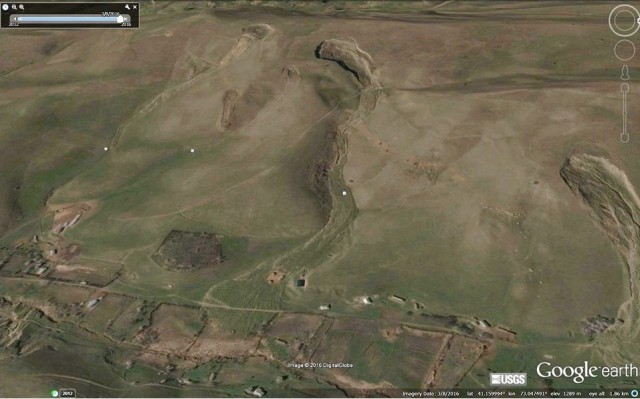
High levels of mobility demonstrated by other landslides close to the Kyrgyzstan loess landslide, via Google Earth
 Dave Petley is the Vice-Chancellor of the University of Hull in the United Kingdom. His blog provides commentary and analysis of landslide events occurring worldwide, including the landslides themselves, latest research, and conferences and meetings.
Recent Comments