
2 January 2018
Yarlung Tsangpo: an ongoing “quake lake” scare in India (with images from Planet Labs)
Posted by Dave Petley
Yarlung Tsangpo: an ongoing “quake lake” scare in India
Just before Christmas a story emerged in the media in India about earthquake-induced landslide dams on the Yarlung Tsangpo river in Tibet. The gist of the story is that the river has been blocked by three large earthquake-induced landslide dams, triggered by the 17th November 2017 M=6.4 earthquake in Tibet. These landslide dams were revealed in an analysis of LANDSAT imagery by Chintan Sheth of the National Centre for Biological Sciences and Anirban Datta-Roy of the Ashoka Trust for Research in Ecology and the Environment, and published in the Assam Tribune. The trigger for this study was a dramatic change in the turbidity of the river.
The presence of these landslides is a remarkably good find, and is interesting. I have taken a look at Planet Labs imagery of the site in question, which is the Gyala Peri mountain block. This is a Planet Labs image of the site prior to the earthquake – indeed this image was captured on 17th November 2017, the actual day of the main shock:-
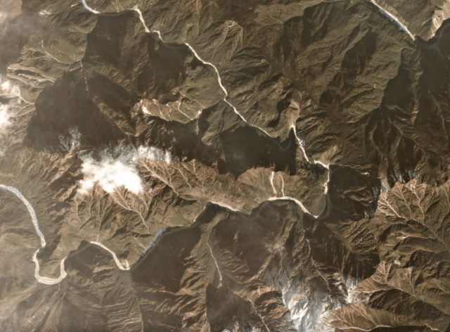
Planet Labs image of the site of the landslides at Gyala Peri in Tiber. Image dated 17th November 2017.
.
Compare that image with this one, also by Planet Labs, captured on 12th December 2017:-
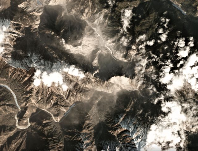
Planet Labs image of the landslides triggered by the 17th November 2017 M=6.4 earthquake in Tibet
.
There is without doubt a dramatic increase in the number of landslides – my view is that this is a significant find, so I congratulate the authors. The original article notes that there are three significant valley-blocking landslides:
A matter of serious concern is the blockage of the river at three locations along a 12 km stretch of the river which falls in the Bayi district, Nyingchi County. Three dams have formed one behind the other (figure from December 20th 2017). While the dams are significantly smaller than the Yigong dam (catastrophe of 2000, volume = 3 billion m³ ), it is too early to rule out the possibility of these three dams from merging and becoming larger. Based on preliminary calculations from low-resolution data, the current total volume of the GyalaPeri dams is about 1 billion m³. Blockage of river flow by debris is unpredictable as the area may be unstable with falling rocks and mud. Real-time satellite monitoring is required to keep track of how the dams are changing allowing the areas downstream in Arunachal Pradesh and Assam to prepare accordingly.
These three landslide dams are located in the area shown in this Planet Labs image, dated 18th December 2017:-
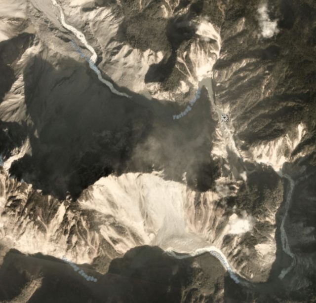
Planet Labs image of the landslide dams on the Yarlung Tsangpo River at Gyala Peri in Tibet
.
A small lake can be seen towards the top of the image – this is the first blockage that the river encounters. The other sites do not appear to be impounding significant amounts of water, and as far as I can see at no point is the river completely blocked. I am slightly surprised that the volume of these landslides is estimated to be a cubic kilometre though.
The presence of these landslide dams has provoked some quite lurid stories in the media about the threats downstream. For example, the Asian Age reports that:
At least three huge artificial lakes holding colossal volumes of water have formed on the Yarlung Tsangpo river in the Great Bend region after a 6.4 Richter scale earthquake struck on November 17, posing a danger of colossal proportions to the people living downstream in Arunachal Pradesh and Assam.
Based on the images above, this is somewhat overblown. At present the threat level is quite different from, for example, the Attabad landslide crisis in Pakistan. However, the original article suggests that:
A panel of remote sensing experts, geologists, hydrologists and disaster management experts need to be set into action right away for the safety and economy of the people. It is also critical for the people of Arunachal to scientifically study the geography and ecology of the region not only prepare for disasters but to develop sustainably.
Which would seem to be good advice.
Reference
Planet Team (2017). Planet Application Program Interface: In Space for Life on Earth. San Francisco, CA. https://api.planet.com
 Dave Petley is the Vice-Chancellor of the University of Hull in the United Kingdom. His blog provides commentary and analysis of landslide events occurring worldwide, including the landslides themselves, latest research, and conferences and meetings.
New Zealand Mt Tasman landslide
1,177mm rain 3 days must be a record? even for our wet Westland valleys