13 April 2013
So was the Tibet landslide, which killed 83 people, really “natural”? You be the judge
Posted by Dave Petley
In the aftermath of the deadly Gyama (Jiama) mine landslide in Tibet a fortnight ago, the Chinese media reported in some detail the undoubtedly brave efforts of the rescue teams in their quest to recover dead – this has been largely successful, although some victims (about 17 as far as I can tell) remain lost. As is often the case, the last set of reports indicated the results of an initial investigation, which indicated that:
Loose rocks triggered a massive landslide that buried 83 workers in southwest China’s Tibet Autonomous Region last Thursday, a geological expert said Tuesday. About 3.5 millon cubic meters of loose rocks remain on top of the mountain that served as the source of the landslide, posing a threat to the rescuers beneath, said Dorje, an academic with the Chinese Academy of Engineering. Dorje has conducted a field investigation into the cause of the disaster, which occurred around 6 a.m. last Thursday. Dorje said the area that the landslide originated from was previously covered by large glaciers. Rocks hidden under the glaciers broke into smaller, loose rocks over a long period of time due to thermal expansion and contraction stress, as well as rainy and snowy weather. Dorje said smaller rocks near the source of the landslide collected together and snowballed into a massive landslide that was incredibly destructive.
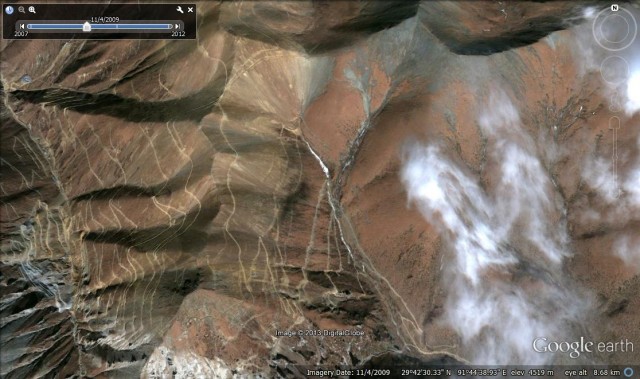
So in essence the landslide was a dreadful tragedy that was natural, according to this expert. Of course even that does not necessarily absolve those responsible for the mine of blame because if the mountains were prone to such events then the camp should not have been in such a dangerous location, but that is a side issue. The key is whether this explanation of the event is credible. So why would we think that it might not be? Well, first up from a technical perspective there is something really odd about the landslide; this is that it has travelled a remarkably long distance. The reported volume is 2 million cubic metres and we know from the photo evidence that it occurred in this particular valley:
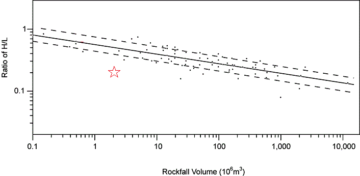
So we can use Google Earth to get a first order estimate of the height: length ratio of the landslide. The report is that it travelled about 3 km down the valley, which would imply a height change of about 700 metres (according to a crude measurement from the imagery). The ratio between these two parameters gives us a rough indication of the mobility of the landslide – i.e. how far it went given the vertical distance it travelled. We know that big (in terms of volume) landslides tend to be more mobile than are small ones; indeed this relationshop has been extensively explored in the literature. So lets compare the Jiama mine landslide with previous examples. In a paper a few years ago, Li (1983) plotted this up data for large rockfalls and fitted a best fit line. I have added a star to indicate the approximate position of this event:
In other words this landslide event seems to have been exceptionally mobile – much more so than were other rockfall type landslides of a similar size. That in itself is surprising, especially as it did not travel across a very low friction surface such as a glacier. Of course Google Earth only gives us a rough estimate of the parameters, so the error bars are large, but even if you take this into account the landslide appears to have been very mobile, indicating that something rather strange has happened here. It could of course be that the very narrow valley played a role in some way, so there could be a natural explanation, but it does suggest we should be looking at this in more detail.
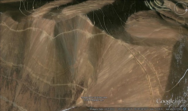
So let’s take a look at the site. This is the slope that failed as shown on the standard Google Earth image, taken with a perspective view:
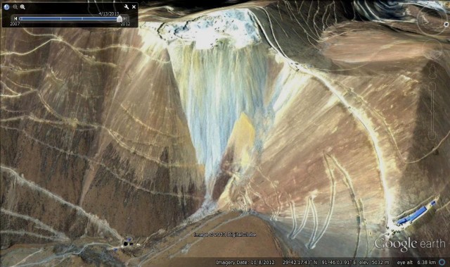
There are clearly a set of mining tracks across the hillside, but otherwise this looks like weathered rock in a reasonably natural state. However, this image was collected in July 2010. Hidden in Google Earth is a more recent, and more interesting image, dated 10th August 2012:
To me this is a sensational image. It shows that the slope that failed had been subject to a huge mining operation – basically a mountain-top removal exercise. Perhaps more importantly, the spoil that has been removed has been dumped down the slope that subsequently collapsed. The scale of this operation is very large, and it is notable that the spoil has mostly accumulated on the upper part of the slope, although some has passed to the foot of the slope.
So, how come the Chinese news reports about the event did not mention this huge modification of the slope. Remember that Mr Dorje said:
Rocks hidden under the glaciers broke into smaller, loose rocks over a long period of time due to thermal expansion and contraction stress, as well as rainy and snowy weather. Dorje said smaller rocks near the source of the landslide collected together and snowballed into a massive landslide that was incredibly destructive.
He neglected to point out that a large volume of loose rock had been dumped in the upper portion of the slope due to mining. The idea that a small failure turned into a very large collapse is a good one; it is the source of the material that is the issue. The volumes are interesting too – the excavation is about 300 x 330 metres – i.e. a surface area of about 100,000 square metres. If an average of 20 metres of rock has been removed, which seems reasonable, the volume of spoil is about 2 million cubic metres. This would seem to be a reasonable fit to the reported volume of the landslide.
So, does this answer why the landslide was so mobile? It certainly provides a possible explanation. Most of the landslides in the Li (1983) dataset were natural failures, consisting of rock blocks that had to go through massive fragmentation at the foot of the slope. Breaking rock is very energy intensive, which means that there is less energy available to move the mass. In the Jiama mine landslide case, the rock mass had been fragmented before the failure, which would have allowed a much more efficient run-out process.
Of course I cannot definitely say what happened at this slope in Tibet, and I cannot rule out the possibility that it was a natural event. I will allow you to be the judge of that, and welcome comments and thoughts. If you want to look at the imagery the site is at: 29.703978° N, 91.762919° E
Finally, I am also aware that there are other reports and analyses of this landslide online now. I will link to those in a post in the next day or so. I quite intentionally wrote this post independently of those reports – this is my best analysis of the events at Gyama Mine. It leaves a lot of important questions hanging.
Reference
Li, Tianchi, 1983, A mathematical model for predicting the extent of a major rockfall, Zeitschrift fur Geomorphologie, 27 (4): 473-482.


 Dave Petley is the Vice-Chancellor of the University of Hull in the United Kingdom. His blog provides commentary and analysis of landslide events occurring worldwide, including the landslides themselves, latest research, and conferences and meetings.
..”So, how come the Chinese news reports about the event did not mention this huge modification of the slope.”
Really, not to be surprised, there is no way they will imply all the facts…unfortunately. 80+ deaths likely could have been avoided by spending <75$ an hour for active monitoring.
This sounds and looks like an alpine mine waste dump failiure; not uncommen for mines in mountainius terrrain. Valley confinemnt plays a significant role in the debris runout. Spoils of this nature are monitored in 1st world countries because of the experience with dozens of failures since the early 1980’s
Complimentary ‘must read’ mention by Sam Geall on shanghailist of Dave Petley’s blog posts about the Gyama Landslide. But no direct links unfortunately http://shanghaiist.com/2013/12/30/_10_the_persistent_pall.php
Sam Geall’s ‘shanghilist’ piece has been reposted with the original links, including those to Dave Petley’s blog posts, added http://shanghaiist.com/2013/12/30/_10_the_persistent_pall.php