
2 February 2010
The causes of the Shiaolin landslide disaster in Taiwan
Posted by Dave Petley
The Shiaolin landslide disaster in Taiwan, which occurred during typhoon Morakot last August, has been the source of huge controversy. To recap, the landslide, which occurred during an exceptional rainfall event, wiped out Shiaolin village, killing about 500 people. The controversy centred on two key aspects – first, the perceived very slow response of the government to the disaster and second the possibility that tunneling associated with the Zengwen Reservoir project may have been a contributing factor to the slope failure. In response the Executive Yuan of Taiwan commissioned an investigation from the Public Construction Commission, which released its final report yesterday.
The report is of course in Mandarin, but very helpfully there is a powerpoint file available that summarises the findings and provides some illustrations of the key issues. This powerpoint file is available here (warning it is a large file in Powerpoint in pptx format):
http://www.pcc.gov.tw/pccap2/FMGRfrontendDownloadQuoteFile.do?fileCode=F2010020012
The report is available here:
http://www.pcc.gov.tw/pccap2/FMGRfronten/DownloadQuoteFile.do?fileCode=F2010020011
The key finding of the report is in my view correct – this is that the tunnel project was not the cause of this landslide disaster – they factor was the exceptional rainfall experienced in this event. The powerpoint file provides a dramatic illustrations of the magnitude and intensity of this rainfall:
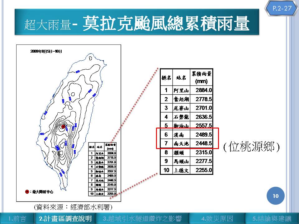
Click on the image for a better view in a new window. The map on the left is the recorded rainfall for the storm, the table on the right is the total rainfall for a number of stations in the worse affected area. Note that the precipitation totals are extreme in every sense of the word – c.2500 mm (2.5 metres of rain) is the equivalent of three years total rainfall for the temperate area in which I live. This is the largest rainfall event ever recorded in Taiwan, and probably the most intense rainfall event worldwide for half a century.
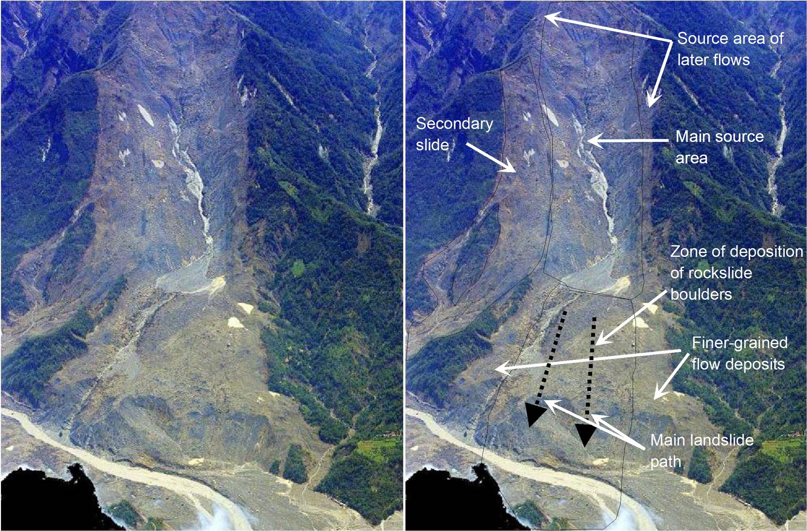
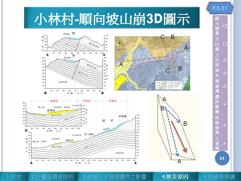
The report shows that disturbance associated with the tunnel is not sufficient to be a factor in the landslide – a conclusion that I support. Instead, they show that the slope underwent a dip slope failure that led to a massive rockslide that destroyed the village. The report suggests that the landslide had a maximum depth of about 86 m and a volume of 2.5 million cubic metres. From what I can tell the slide itself was a wedge failure with a dip-slope defining part of the wedge.
There is only one aspect of the report that continues to cause concern. This is the interpretation of the mechanism of failure. This slide shows a long profile of the landslide site, which shows bedding parallel to the slope right down to the river (section A-A’):
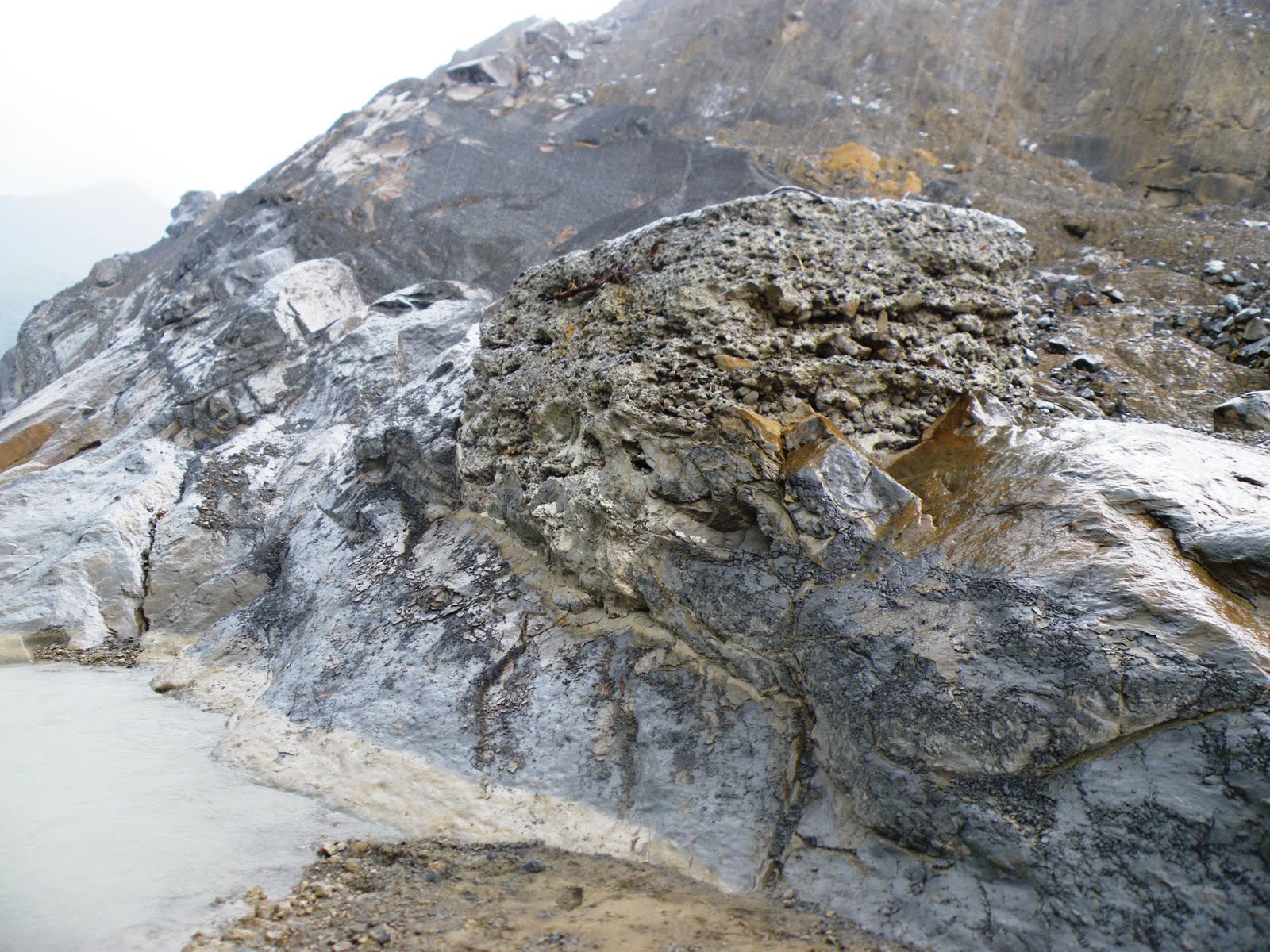
 This just doesn’t seem to accord with what Chris Massey and I observed on site at the toe of the slope:
 This picture is taken from the north end of the toe of the slope looking upstream – note the bedding on the far side of the valley – this is near vertical.
 This picture was taken at the site of the old bridge abutment at the toe of the slide (the concrete in the middle of the image is this abutment I think) – again, note the very steeply dipping rocks at this point.
The final point to make is that the Shiaolin landslide was of course not the only failure to occur in the area during Morakot. Mapping of this region has identified 880 landslides covering an area of 2058 hectares (20.88 square kilometres).
There can be no doubt that Morakot was an extraordinary event.
 Dave Petley is the Vice-Chancellor of the University of Hull in the United Kingdom. His blog provides commentary and analysis of landslide events occurring worldwide, including the landslides themselves, latest research, and conferences and meetings.
can you let me join in your blog?i am interested in disaster preparednes.. this is my email [email protected] you
can i join to your blog,i am really interested in disaster preparedness. this is my email : [email protected]
[…] little under two years ago, on 9th August 2009, Typhoon Morakot triggered a catastrophic landslide that destroyed the village of Hsiaolin in southern Taiwan, killing over 400 people. I covered this event in detail at the time and later that same year […]
[…] 100 mm per hour, and the total rainfall from this single storm exceeded 2700 mm. Unsurprisingly, the impacts were catastrophic. Unfortunately, the lack of understanding of the rainfall impacts of tropical cyclones leads to a […]