1 September 2011
Reflections on Hurricane Irene – it’s as much to do with water as wind
Posted by Dave Petley
There is a widely held perception that the impact of tropical cyclones (i.e. hurricanes and typhoons) is primarily associated with wind damage. Indeed, the standard way of categorising the strength of a tropical cyclone is the Saffir-Simpson scale, which is essentially a measure of peak sustained wind speed. There is no doubt that wind is an exceptionally damaging component of tropical cyclone impacts, and that it also plays a key role in determining the magnitude of a storm surge. However, take a look at this gallery of before and after images of the impact of Hurricane Irene (and I should add that this is not a website that I would recommend browsing more widely…). The most striking thing is that the images show the impact of water, not wind. Indeed, for most tropical cyclones it is water that does the damage – whether it is in the form of a storm surge, river floods or landslides. This focus on wind is in my view a dangerous misconception about tropical cyclones.
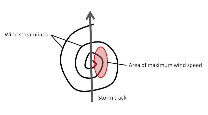
Let me give an example. For wind speed, the greatest impacts are likely to come where a very strong tropical cyclone is moving quickly. This simple diagram illustrates how the forward track of the tropical cyclone and the circulating winds serve to increase the impact of the storm:
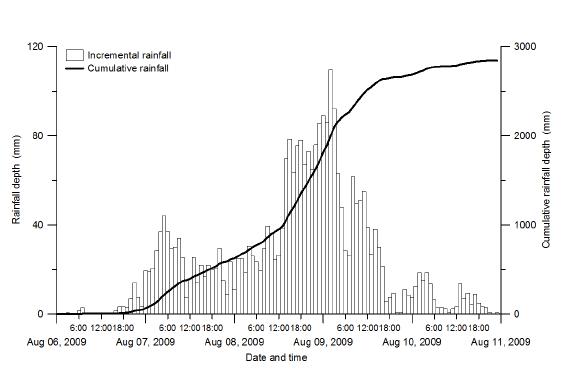
 However, for damage associated with rainfall, exactly the opposite is the case. If the storm moves quickly, then the area of most intense precipitation passes rapidly over a given spot, and the damage is more limited. The real problems with rainfall often occur when the storm effectively stalls (i.e. stops), allowing really intense rainfall over a long period. And tropical cyclone precipitation is extraordinary. This graph, from Shieh et al. (2010), shows hourly and cumulative rainfall from the 2009 Typhoon Morakot in Taiwan:
 Note that the peak rainfall intensities are in excess of 100 mm per hour, and the total rainfall from this single storm exceeded 2700 mm. Unsurprisingly, the impacts were catastrophic. Unfortunately, the lack of understanding of the rainfall impacts of tropical cyclones leads to a lack of preparation at both an individual and a societal level, and a sense of surprise when rainfall-induced disasters occur.
So, there seems to me to be an urgent need to do two things. The first is to improve understanding of the range of impacts associated with tropical cyclones, and in particular with respect to rainfall induced disasters. Second, it really is time that we improved the Saffir-Simpson scale to encompass more than wind speed, such that the potential impacts of an impending tropical cyclone can be properly assessed. This is clearly not a trivial task, but it would seem to be an urgent research need.
Reference
Shieh, C-L. et al. 2010. An overview of disasters resulted from typhoon morakot in Taiwan. Journal of Disaster ResearchVol.5, No.3, 236-244.


 Dave Petley is the Vice-Chancellor of the University of Hull in the United Kingdom. His blog provides commentary and analysis of landslide events occurring worldwide, including the landslides themselves, latest research, and conferences and meetings.
[…] […]
[…] last week I noted that the rain-induced impact of tropical cyclones can be enhanced if they move slowly. Right on cue, typhoon Talas has illustrated the point as it made landfall in southern Japan. […]
[…] once again this highlights that our classification of tropical cyclones is not fit for purpose, as I have previously noted. The current classification of tropical cyclones is undertaken on the basis of wind parameters, […]
[…] make landfall in a few hours from now in NE India; this remains an extremely dangerous storm. As I have noted previously, although we categorise tropical cyclones on the basis of wind strength, most of the damage is […]
[…] make landfall in a few hours from now in NE India; this remains an extremely dangerous storm. As I have noted previously, although we categorise tropical cyclones on the basis of wind strength, most of the damage is […]