
16 May 2017
The Pas de l’Ours landslide: an actively moving rockslide in the Queyras Valley of France
Posted by Dave Petley
The Pas de l’Ours landslide: an actively moving rockslide in the Queyras Valley in France
Clément Hibert and his colleagues (see full list below) at the University of Strasbourg have kindly provided information about a landslide that they are currently monitoring in the Queyras Valley in France. This rockslide, known as the Pas de l’Ours landslide, is located about 400 m upstream of the town of Aiguilles. It is quite easy to spot on Google Earth:-
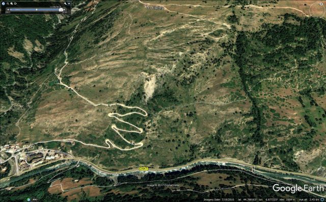
Google Earth image of the Pas de l’Ours landslide in the Queyras Valley
.
This rockslide is large – Clément has provided the annotated image below to show its scale:-
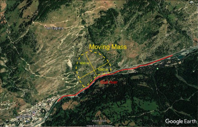
The Pas de l’Ours landslide in the Queyras Valley, image via Clément Hibert
.
Clément describes the landslide thus:
It has developed in unconsolidated schists and moraines. The total volume of the moving mass is estimated at 15 millions cubic meters, with a width of the unstable area of 1 km and a length of 600 m , which makes it one of the largest active slow-moving landslide in the Alps.
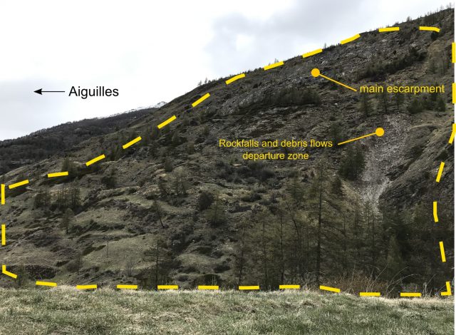
Panoramic view of the Pas de l’Ours landslide in the Queyras valley, via Clément Hibert
Since April 2017, numerous rockfalls and large deformation of the road at the foot of landslide have been observed (see image below), which led the local authorities to contact the University of Strasburg team to deploy a monitoring system. The principal threat identified is the possibility that a large part of the mass would collapse suddenly and block the Guil river in the valley below. This could create an important natural dam and totally block the access to two towns (800 inhabitants) located upstream in the Queyras valley.
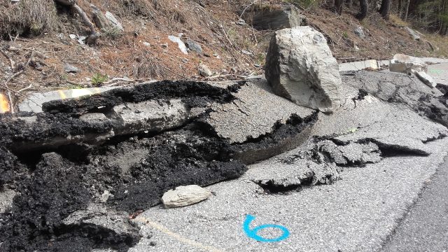
Deformation of the road at the toe of the Pas de l’Ours landslide in the Queyras Valley
.
Whilst the morphology of the landslide also suggests extensive ongoing deformation:-
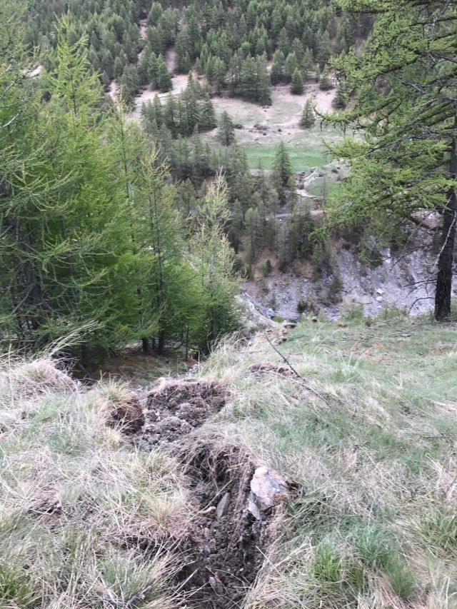
Signs of deformation in the Pas de l’Ours landslide in the Queyras Valley. Image via Clément Hibert
.
Because the landslide is moving so rapidly, the University of Strasbourg team have deployed INSAR monitoring at the site. This data suggests that parts of the landslide are moving at over 50 cm per day. The image below shows a deformation map from one of these campaigns – the movement is between 05/05/2017 and 08/05/2017:-
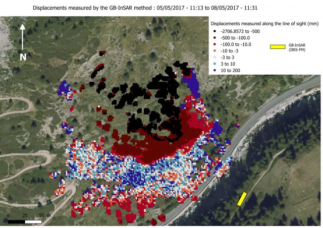
INSAR map of ground deformations at the Pas de l’Ours landslide in the Queyras Valley, via Clément Hibert
.
The team undertook further monitoring over the weekend, and have produced the deformation maps below. Note the very high movement rates now being recorded:-
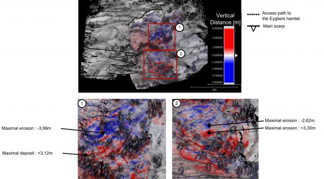
Ground based INSAR deformation map of the Pas de l’Ours landslide in the Queyras Valley between 5th and 9th May 2017, via Clément Hibert
.
The team have animated these measurements into a Youtube video. The video presents the displacement observed along the line of sight of the Ground-Based SAR. The displacements are averaged on a moving time window of two hours, and were measured during the period between 5th and 9th May 2017. It shows that the zone affected by the strongest deformation is extending toward the foot of the landslide during this period. The colours represent the displacements along the line of sight of the GB-Sar. Red indicates that the point has moved toward the instrument, blue away from the instrument, with the amplitude given by the colourscale. The yellow-ish 3D rectangle shows the position and the orientation of the instrument, so in this video we are looking at the landslide from the opposite side of the valley, slightly above the instrument. The river and the road, located at the toe of the landslide, are at the limit between the grey and the black area of the DEM.
.
It seems likely that we will hear a lot more about this landslide in the months ahead.
I must thank Clément and his colleagues at the University of Strasbourg for providing this information about a fascinating ongoing landslide problem. The team consists of:
- Jean-Philippe Malet (Team leader – University of Strasbourg / EOST),
- Clément Hibert (EOST)
- Anne Puissant (LIVE)
- Floriane Provost, (EOST)
- Grégoire Skupinski, (LIVE)
- Pierrick Bornemann (LIVE/EOST)
- Elouan Faustin (EOST)
- Gilbert Ferhat (EOST)
- Marc Fleck (University of Strasbourg / Faculty of Geography)
The monitoring system and the research carried out on site received invaluable support from the ONF-RTM (Restauration des Terrain de Montagne) service, especially from Pascal Diot and Vincent Ségel.
 Dave Petley is the Vice-Chancellor of the University of Hull in the United Kingdom. His blog provides commentary and analysis of landslide events occurring worldwide, including the landslides themselves, latest research, and conferences and meetings.
Le glissement de terrain s’est mis en marche…. Il a fait tomber les blocs du mur de protection, ouvert une brèche et la boue a envahi la route, elle passe par dessus le muret de la route et coule dans le Guil la rivière…. la route est fermée depuis plus d’une semaine, la route de secours est en fonction depuis le 13 mars et on attends la suite….. A Aiguilles le vendredi 30 mars 2018
[Many thanks. A rough translation of this is:
The landslide started …. It dropped the blocks of the wall of protection, opened a breach and the mud has invaded the road, it passes over the wall of the road and flows into the river Guil …. the road has been closed for more than a week, the emergency route has been in operation since March 13 and we are waiting for the rest … .. Aiguilles, Friday 30 March 2018. D.]