
11 May 2017
Taiwan landslide hotspots: changing patterns through time
Posted by Dave Petley
Taiwan landslide hotspots: changing patterns through time
Taiwan is one of the most landslide-prone countries on earth due to the combination of steep terrain, high rates of uplift, extraordinary rainfall events and regular seismicity. Fortunately, most landslides occur in the relatively sparsely populated Central Mountains, although fatalities do occur every year. Not surprisingly, Taiwan has an active high quality landslide research community and a government that is proactive in terms of slope management.
A paper just published in Landslides (Lin et al. 2017) examines an extraordinary multitemporal landslide dataset for Taiwan collected by the Forest Bureau using the Formosat-2 satellite. This may well be the most comprehensive long term landslide dataset in existence – the data includes mapped landslides across the whole of Taiwan on an annual basis from 2003 to 2012. Lin et al.(2017) have examined the changes in landslide patterns across Taiwan over this period; and the results are pretty exciting.
This is just one of the graphs from the paper. It shows the landslide ratio – the proportion of the terrain that consists of active landslides – for a number of catchments in both northern and southern Taiwan each year from 2003 to 2012:
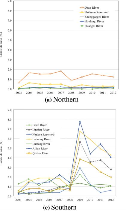
Taiwan landslide hotspots: the landslide ration through time for northern and southern Taiwan, from Lin et al. (2017).
.
Until 2008 the landslide ratio for both areas was roughly similar at around 0.5-2%. Southern Taiwan was slightly higher than northern Taiwan, perhaps, probably because the terrain in the south is more rugged. But a dramatic change occurred in southern Taiwan after 2008, with no corresponding effect in northern Taiwan. In 2009 the landslide ratio suddenly dramatically increased in the south. Thereafter the landslide ratios in southern Taiwan were much higher, although they also started to decline thereafter.
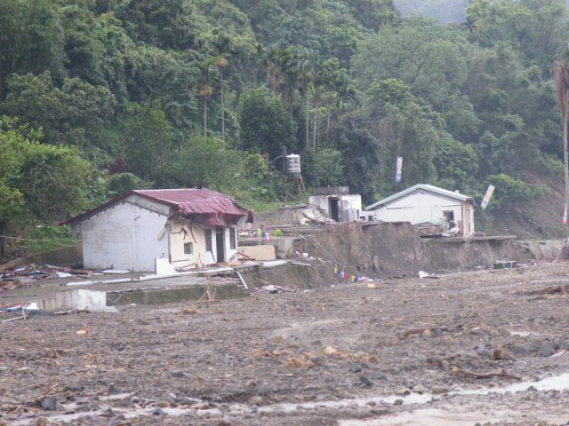
Taiwan landslide hotspots: damage from debris flows in the aftermath of typhoon Morakot
.
So what happened in 2009 in southern Taiwan? Quite simply this is the effect of the extraordinary Typhoon Morakot, which brought vast amounts of rainfall to southern Taiwan, and triggered thousands of landslides, including the dreadful Shiaolin event. The paper shows very elegantly that these extreme events leave a long term legacy of increased landsliding for years afterwards. This effect is well documented for large earthquakes in mountain chains; this paper shows very nicely that there is a similar effect for large rainstorms too.
Catastrophic rainfall events are both immediate disasters and long term crises. This latter effect is all too frequently forgotten.
Reference
Lin, S.C., Ke, M.C. & Lo, C.M. 2017. Evolution of landslide hotspots in Taiwan. Landslides. doi:10.1007/s10346-017-0816-9
 Dave Petley is the Vice-Chancellor of the University of Hull in the United Kingdom. His blog provides commentary and analysis of landslide events occurring worldwide, including the landslides themselves, latest research, and conferences and meetings.
Dear Professor Petley:
Thanks a lot for your review of paper ‘Evolution of landslide hotspots in Taiwan.’ in the landslide blog. The landslide ratio in southern Taiwan dramatic change in 2009, not in 2008. The typhoon Morakot also attacked Taiwan in 2009. If you require any further information, feel free to contact me.
Yours sincerely,
Sheng Chi, Lin