

17 January 2018
The fascinating Rattlesnake Hills landslide in Washington State
The fascinating Rattlesnake Hills landslide in Washington State
In Washington State the Rattlesnake Hills landslide continues to develop under conditions of close scrutiny from the media. The Washington Department of Natural Resources (WA DNR) has a website dedicated to the problem, which includes the following schematic map of the monitoring that is being undertaken and the broad patterns of movement:
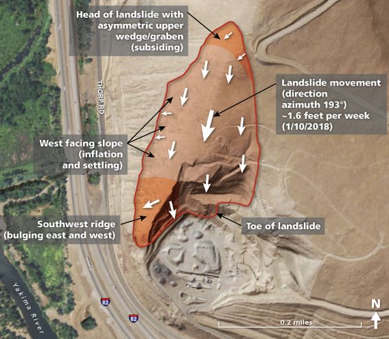
WA DNR schematic map of movement patterns for the Rattlesnake Hills landslide.
.
The map indicates a highly complex landslide with what I would consider to be an unusual movement pattern, with displacement apparently approximately parallel to the ridgeline. This is probably associated with the underlying geological structure, WA DNR interpret it as sliding on a silty layer between fractured basalts, dipping at about 15° into the quarry. This of course asks questions about how the quarry was permitted in such geological setting (on the face of it, the setting as described by WA DNR appears to be quite prone to instability), but that is a different issue.
WA DNR have extensive monitoring on the slope, including GPS monitoring sites, prisms for total stations, ground-based LIDAR and of course mapping of the slope. This is a good combination, and the authorities have retained the skills of a number of specialists. If find the drone images of the tension cracks very interesting – this video was published on Youtube on 13th January:-
.
Particularly interesting is the comparison between the deformation on the east and west flanks of the landslide:-
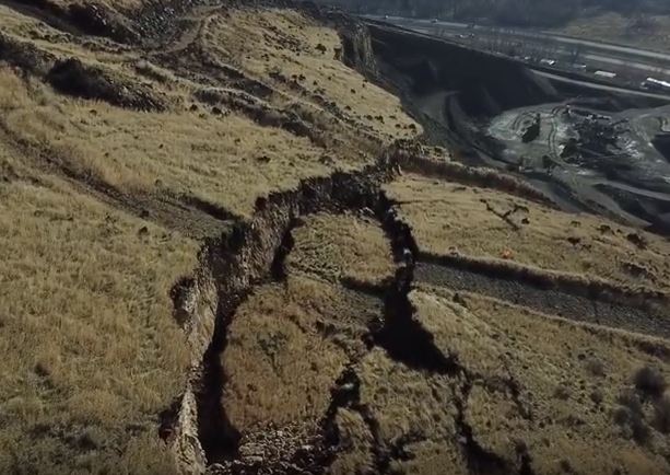
Deformation on the east flank of the Rattlesnake Hills landslide, via a Youtube drone video
.
Meanwhile on the west side the deformation is quite different, with limited ground cracking and some bulging:-
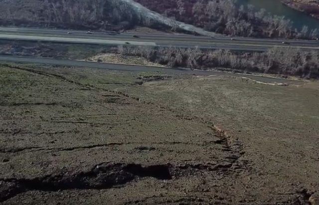
Deformation on the west side of the Rattlesnake Hills landslide, via a Youtube drone video.
.
This suggests a highly complex movement pattern that is hard to interpret without proper data (which WA DNR are collecting). I can understand why the authorities are being so cautious about predicting the time of final collapse. This one will be interesting to observe over the coming weeks.
16 January 2018
Satellite images of the Montecito debris flows in California
Satellite images of the Montecito debris flows in California
Last week significant debris flows struck the Montecito area of California. At least 20 people were killed, with a further four people reported as being missing. The highly mobile flows barreled down three major gullies, the Montecito, San Ysidro, and Romero creeks in the hills to the north of the community. This area was severely burnt by the Thomas Fire in December. The vulnerability of the area affected by the fire to landslides had been highlighted in advance.
Planet Labs have now imaged the area affected by the landslides, and have kindly made the imagery available to me. Once again I am amazed at the quality of the images that they are able to collect. This image, collected on 10th January, 2018, shows the area affected by the landslides:-
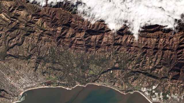
Planet Labs image of the Montecito debris flows area
.
Note the severely burnt and eroded area to the north of the town. and the obviously denuded hillsides that were the source of the flows. The high resolution Planet Labs image below provides a perspective on the area affected by the flows themselves:-
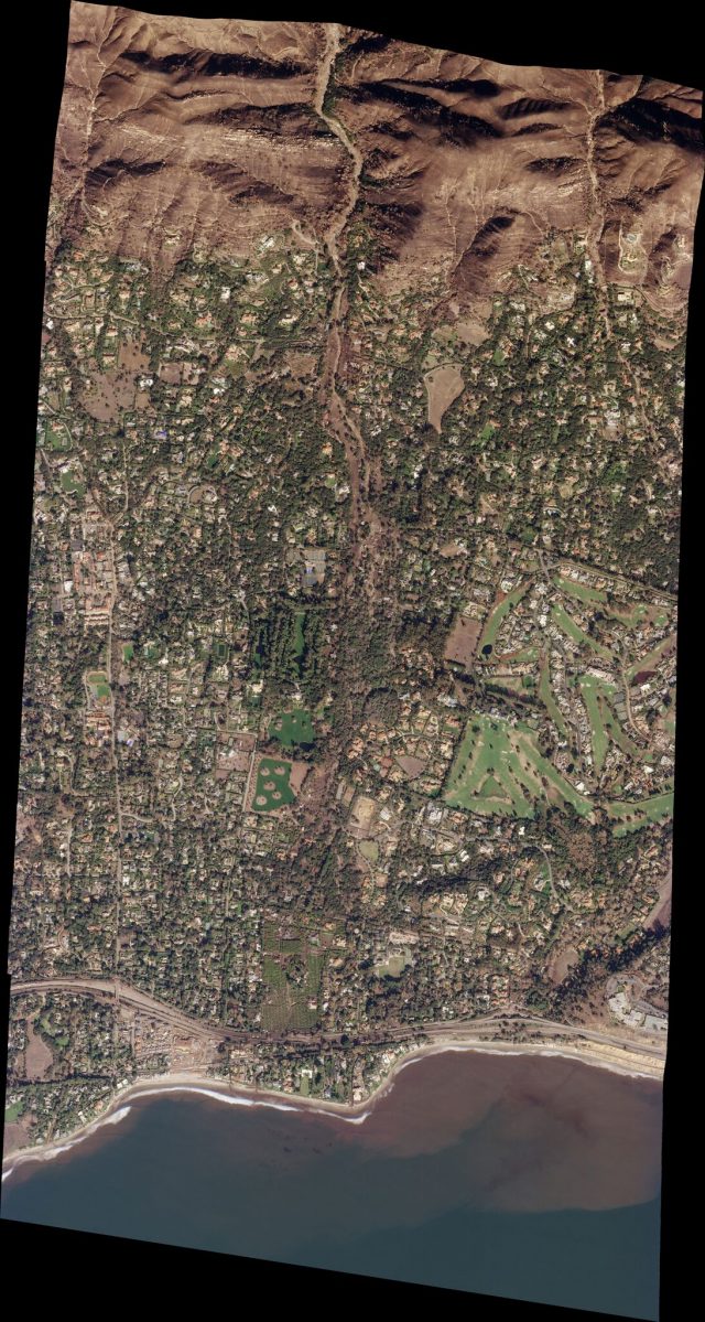
High resolution Planet Labs image of the Montecito debris flows
.
The flow emerging from the gully is clear in the image once you look carefully. The imagery shows the extraordinary trail of destruction left by the flows all the way from the mouth of the gully to the coast. This is a more detailed image of the area close to the mouth of the gully:-
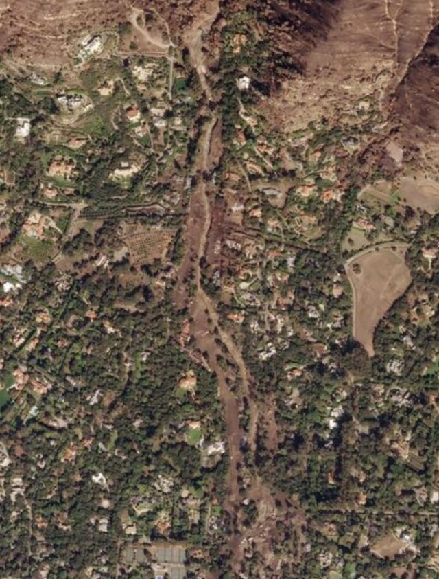
Planet Labs image of the damage caused by the Montecito debris flows.
.
The swathe of destruction caused by the flows is clear – in places it is even possible to see partially buried houses. This damage continues to a greater or lesser extent all the way to the coast. The image below shows the southern part of the town – note the inundation on the east-west highway:
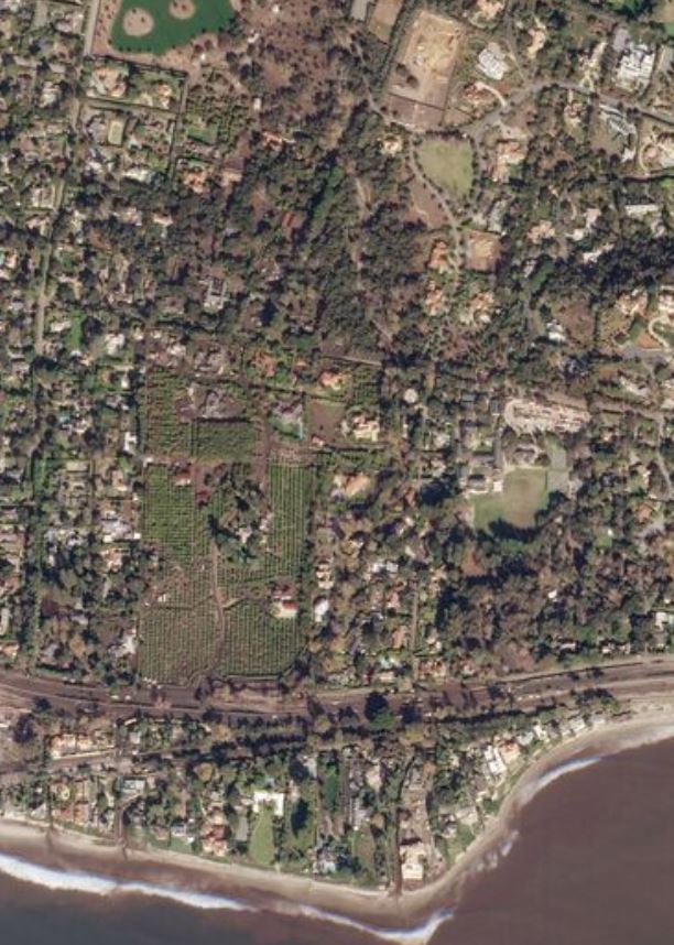
Planet Labs image of the southern part of the Montecito debris flows
.
Reference
Planet Team (2017). Planet Application Program Interface: In Space for Life on Earth. San Francisco, CA. https://api.planet.com
14 January 2018
Villa Santa Lucia landslide in Chile – high resolution satellite images from Planet Labs
Villa Santa Lucia landslide – high resolution satellite images
At last the clouds have cleared sufficiently above the area affected by the Villa Santa Lucia landslide in Chile , which killed 18 people on 16th December 2017, to become visible to optical satellites. Planet Labs captured a very high quality image of the area, including the full length of the landslide, on 11th January. Further images have been collected since. This is a 3 m resolution image of the whole of the landslide:-
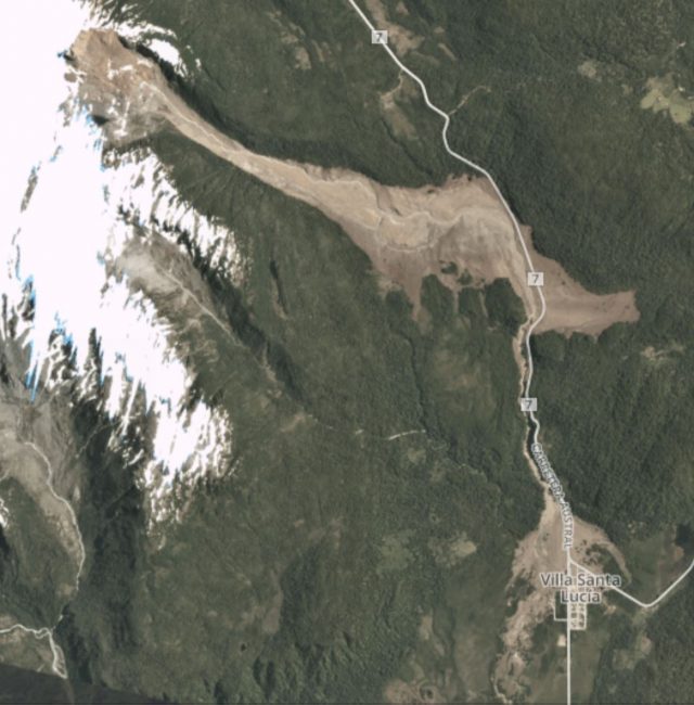
Planet Labs image of the Villa Santa Lucia landslide. 3 m resolution imagery collected on 11th January 2018
.
The landslide consists of three main sections – a rotational landslide in the scarp area, a flow type landslide that has deeply eroded the channel (and deposited material at the toe), and a smaller flow along the steep, narrow channel adjacent to Highway 7, which then spread across the fan to bury a part of the village of Villa Santa Lucia.
This is a Planet Labs image of the source of the landslide. Note the band of snow in the scarp area that marks the top of the slumped and rotated block. Much of this block is intact:-
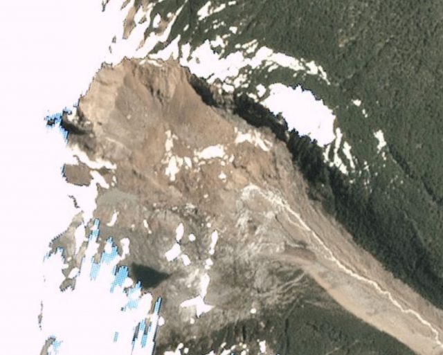
Planet Labs image of the source area of the Villa Santa Lucia landslide. 3 m resolution imagery collected on 11th January 2018. Note that the slide involved the more pink material towards the top of the image,. The duller grey rock in the bottom left side was not involved.
.
The main part of the track of the landslide appears to be a zone of intense erosion and entrainment, with deposition occurring on the margins and at the toe of the landslide:-
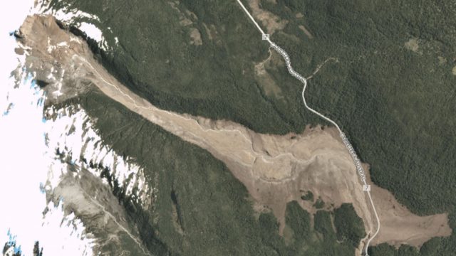
Planet Labs image of the main track of the Villa Santa Lucia landslide. 3 m resolution imagery collected on 11th January 2018.
.
A portion of the slide then turned 90 degrees and travelled down the narrow gully to Villa Santa Lucia. It spread across the fan to engulf the northern part of the village:-
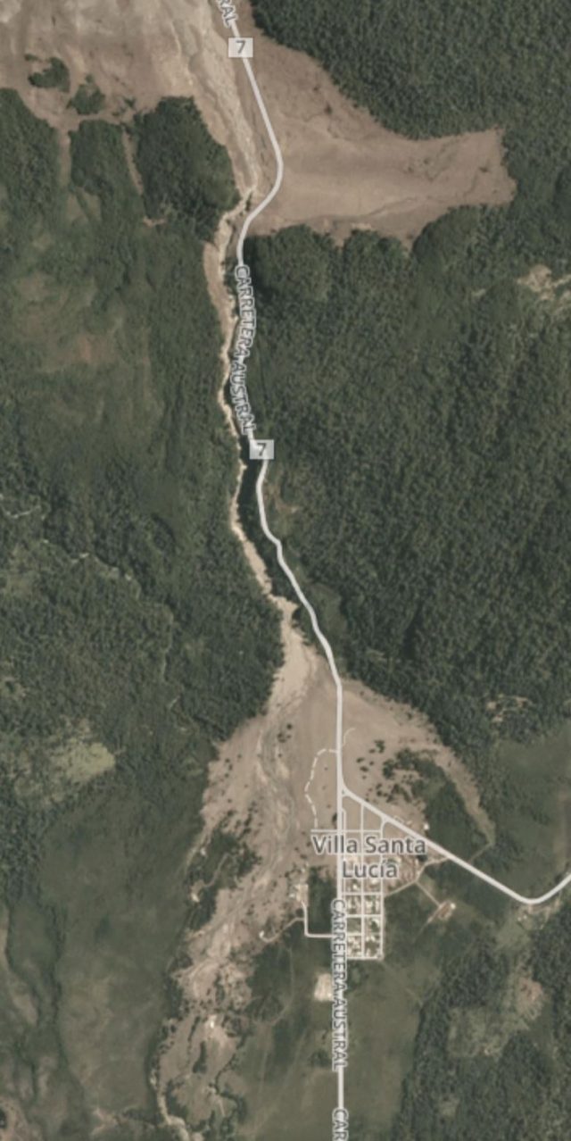
Planet Labs image of the portion of the Villa Santa Lucia landslide that struck the village. 3 m resolution imagery collected on 11th January 2018.
.
It is this lower portion of the landslide upstream of the town that was caught in the video that is now on Youtube:-
.
Reference
Planet Team (2017). Planet Application Program Interface: In Space for Life on Earth. San Francisco, CA. https://api.planet.com
4 January 2018
The Karrat Fjord rock avalanche: a new paper examining the 3D geometry
The Karrat Fjord rock avalanche: a new paper examining the 3D geometry
The Karrat Fjord rock avalanche was the large, dramatic slope failure in Greenland in June 2017 that generated a localised tsunami, resulting in four deaths. I covered this extensively last year, in part because of the dramatic videos of the tsunami itself, and in part because of the interesting interpretations of seismic data associated with the landslide. We are now starting to see the first papers being published about this slide – I suspect we will see a number over the coming years. I have already highlighted one that examined precursory seismic activity. The journal Landslides has now published a paper (Gauthier et al. 2017) based upon a set of 3D reconstructions of the Karrat Fjord rock avalanche, constructed from aerial imagery collected by helicopter.
This study starts to provide some very helpful constraints on the landslide. The image below, from Gauthier et al. (2017) compares a conventional image with the 3D reconstruction:
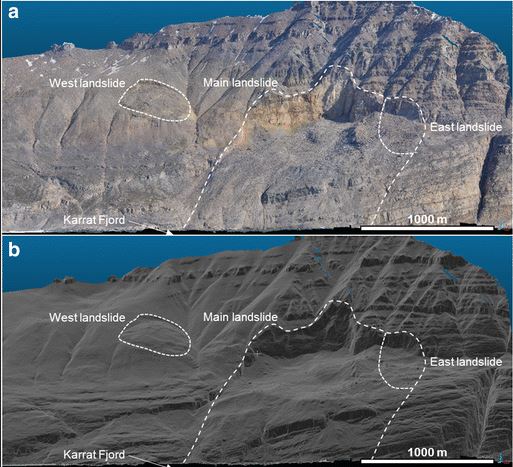
Image from Gauthier et al. (2017) comparing conventional photography with the 3D reconstruction of the landslide scar for the Karrat Fjord rock avalanche.
.
The statistics for the Karrat Fjord rock avalanche are impressive. In total the team estimate that the landslide had a total volume of 58 million m³, of which 13 million m³ was deposited along the track and 45 million m³ entered the fjord. The landslide had a near vertical release plane at the rear, but was planar in terms of the sliding motion. The majority of the material travelled over 1000 m vertically, with a maximum fall height of 1270 m. In places that landslide was up to 300 m thick. They classify the landslide as a “tsunamigenic extremely rapid rock avalanche”, with the majority of the material entering the fjord in 2-3 minutes. It is unsurprising that a landslide on this scale was able to generate a local tsunami.
Gauthier et al. (2017) also comment upon the apparently incipient West Landslide, which can be seen in the image above. They note that this landslide first appeared after May 2015; to date it has moved about 50 m without failing catastrophically. Whilst this landslide appears to be shallower than the main slide, Gauthier et al. (2017) note that this needs further study. It is hard to disagree.
I think this is an important study that provides clarity about the nature of the important Karrat Fjord rock avalanche. I hope we will see further studies of the precursory development of the landslide, its motion, and the ways in which it generated the tsunami, in the months ahead. I know that a number of groups are working on this rock avalanche.
Reference
Gauthier, D., Anderson, S.A., Fritz, H.M. et al. 2017. Karrat Fjord (Greenland) tsunamigenic landslide of 17 June 2017: initial 3D observations. Landslides (2017). https://doi.org/10.1007/s10346-017-0926-4.
3 January 2018
Rattlesnake Ridge: a large failure forming in Washington State, USA
Rattlesnake Ridge: a large failure forming in Washington State, USA
Rattlesnake Ridge is a large hillside located above the I-82 highway to the south of the town of Yakima in Washington State, NW USA. The Google Earth image below shows the location of the site (at 46.524, -120.467), taken in May 2017. The image is looking towards the east – note the large active quarry on the south side of the ridge, and other signs of earlier (and smaller scale) excavation on the slope. Note also the proximity of the slope to I-82.
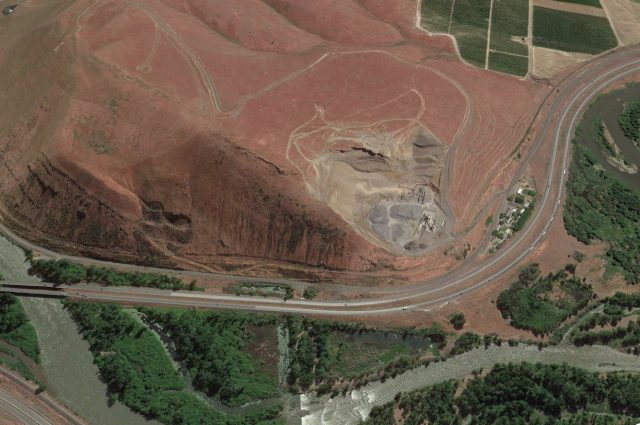
Google Earth image of the incipient landslide at Rattlesnake Ridge
.
In October 2017 a major fissure started to develop through Rattlesnake Ridge. Over the last three months this apparent tension crack has widened to encompass a volume of about 3 million cubic metres. KXLY has this image providing a perspective of the size of the block that is on the move at Rattlesnake Ridge:-
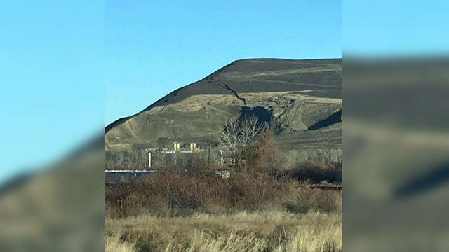
Image of the slope failure at Rattlesnake Ridge, via KXLY
.
Whilst the best impression of the feature can be seen in this Youtube video by Steven Mack:
.
This view of the feature is perhaps the most interesting, showing how the crack extends into the rear face of the quarry.
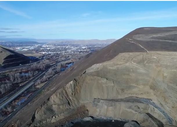
The slope failure at Rattlesnake Ridge. Image from a drone video on Youtube by Steven Mack
.
The latest reports suggest that the crack is widening at a rate of about 30 cm per week at present. Interestingly KIMA TV reports that the expectation is that the slope will self-stabilise:
Senior Emergency Planner Horace Ward said they have not determined a cause yet and said it’s just nature. Ward said the ridge is being monitored and they think the slide will stop itself.
“It could continue to move slowly enough to where it kind of just keeps spilling a little bit of material into the quarry until it creates a toe for itself to stop and stabilize the hillside,” he said.
The implication of this is that it is a rotational slip. However, the tension crack has quite a complex structure, with some evidence of the development of a graben structure:-
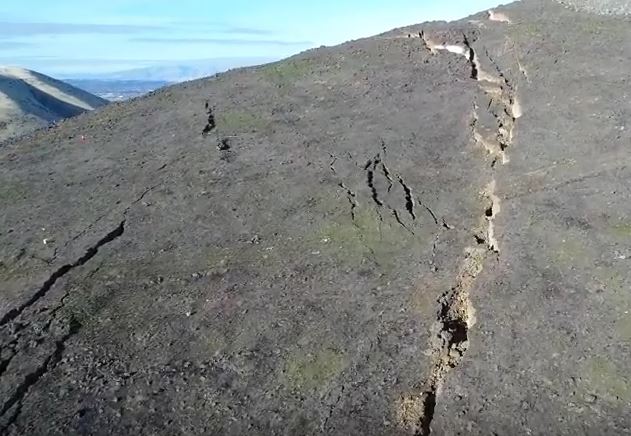
The trension crack at Rattlesnake Ridge. Still from a Youtube video by Steven Mack
.
Combined with the potential for weakening the materials controlling the deformation, this makes forecasting the likely future behaviour of this slope quite challenging, but of course it is the geologists on the ground who are best placed to make a judgement. In the short to medium term high resolution monitoring is the right approach.
Many thanks to the various people who highlighted this one to me, and provided links. Your help is very much appreciated.
2 January 2018
Yarlung Tsangpo: an ongoing “quake lake” scare in India (with images from Planet Labs)
Yarlung Tsangpo: an ongoing “quake lake” scare in India
Just before Christmas a story emerged in the media in India about earthquake-induced landslide dams on the Yarlung Tsangpo river in Tibet. The gist of the story is that the river has been blocked by three large earthquake-induced landslide dams, triggered by the 17th November 2017 M=6.4 earthquake in Tibet. These landslide dams were revealed in an analysis of LANDSAT imagery by Chintan Sheth of the National Centre for Biological Sciences and Anirban Datta-Roy of the Ashoka Trust for Research in Ecology and the Environment, and published in the Assam Tribune. The trigger for this study was a dramatic change in the turbidity of the river.
The presence of these landslides is a remarkably good find, and is interesting. I have taken a look at Planet Labs imagery of the site in question, which is the Gyala Peri mountain block. This is a Planet Labs image of the site prior to the earthquake – indeed this image was captured on 17th November 2017, the actual day of the main shock:-
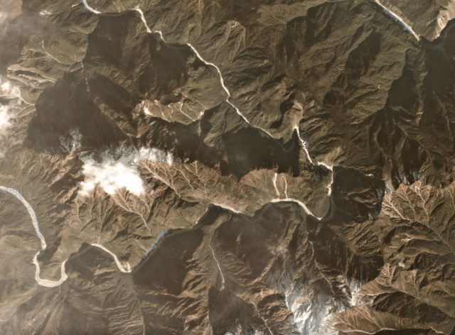
Planet Labs image of the site of the landslides at Gyala Peri in Tiber. Image dated 17th November 2017.
.
Compare that image with this one, also by Planet Labs, captured on 12th December 2017:-
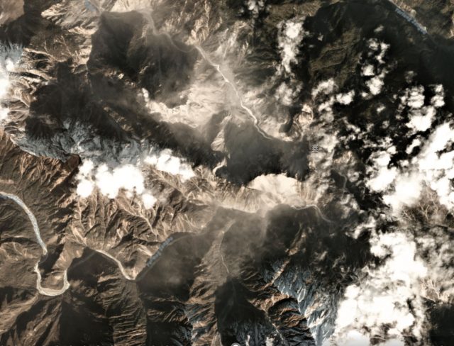
Planet Labs image of the landslides triggered by the 17th November 2017 M=6.4 earthquake in Tibet
.
There is without doubt a dramatic increase in the number of landslides – my view is that this is a significant find, so I congratulate the authors. The original article notes that there are three significant valley-blocking landslides:
A matter of serious concern is the blockage of the river at three locations along a 12 km stretch of the river which falls in the Bayi district, Nyingchi County. Three dams have formed one behind the other (figure from December 20th 2017). While the dams are significantly smaller than the Yigong dam (catastrophe of 2000, volume = 3 billion m³ ), it is too early to rule out the possibility of these three dams from merging and becoming larger. Based on preliminary calculations from low-resolution data, the current total volume of the GyalaPeri dams is about 1 billion m³. Blockage of river flow by debris is unpredictable as the area may be unstable with falling rocks and mud. Real-time satellite monitoring is required to keep track of how the dams are changing allowing the areas downstream in Arunachal Pradesh and Assam to prepare accordingly.
These three landslide dams are located in the area shown in this Planet Labs image, dated 18th December 2017:-
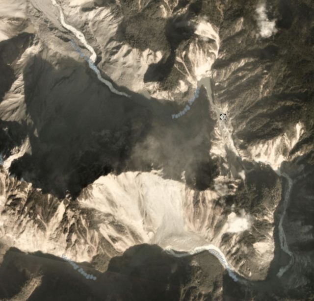
Planet Labs image of the landslide dams on the Yarlung Tsangpo River at Gyala Peri in Tibet
.
A small lake can be seen towards the top of the image – this is the first blockage that the river encounters. The other sites do not appear to be impounding significant amounts of water, and as far as I can see at no point is the river completely blocked. I am slightly surprised that the volume of these landslides is estimated to be a cubic kilometre though.
The presence of these landslide dams has provoked some quite lurid stories in the media about the threats downstream. For example, the Asian Age reports that:
At least three huge artificial lakes holding colossal volumes of water have formed on the Yarlung Tsangpo river in the Great Bend region after a 6.4 Richter scale earthquake struck on November 17, posing a danger of colossal proportions to the people living downstream in Arunachal Pradesh and Assam.
Based on the images above, this is somewhat overblown. At present the threat level is quite different from, for example, the Attabad landslide crisis in Pakistan. However, the original article suggests that:
A panel of remote sensing experts, geologists, hydrologists and disaster management experts need to be set into action right away for the safety and economy of the people. It is also critical for the people of Arunachal to scientifically study the geography and ecology of the region not only prepare for disasters but to develop sustainably.
Which would seem to be good advice.
Reference
Planet Team (2017). Planet Application Program Interface: In Space for Life on Earth. San Francisco, CA. https://api.planet.com
23 December 2017
Villa Santa Lucia rock avalanche – images of the source zone
Villa Santa Lucia rock avalanche – images of the source zone
Over the last few days images have become available of the source zone of the Villa Santa Lucia rock avalanche, which struck southern Chile last Saturday. These include several images of the hillside prior to failure, most notably eight images tweeted by @OldClimber2 that provide views of the scarp area taken in April 2017. This image shows the crown of the scarp, which displays large tension cracks and a fractured rock mass:-
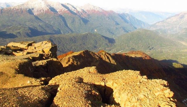
The crown of the source artea of the Villa Santa Lucia rock avalanche. Image via @OldClimber2 on Twitter.
.
Whilst this image shows the deposit in the valley below, which was probably a mixture of colluvium and moraine (others will be able to judge this better than can I).
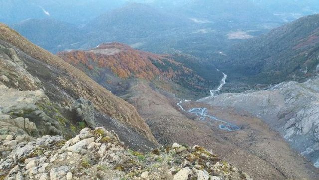
The deposit below the scarp of the site of the Cilla Santa Lucia rock avalanche in Chile. Image via @OldClimber2 on Twitter
.
Meanwhile, @Sub_Interior have tweeted images of the site after the landslide. This image shows the landslide scarp:-
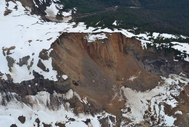
The landslide scarp for the Villa Santa Lucia rock avalanche. Image via @Sub_Interior on Twitter
.
Whilst this image shows the scarp and the start of the debris trail:-
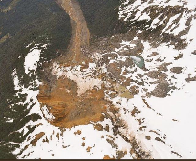
The scarp and debris train from the Villa Santa Lucia rock avalanche. Image via @Sub_Interior on Twitter.
.
Based on this it appears that the landslide consisted of a large volume rock slope failure that collapsed onto the colluvium and moraine at the based at the slope. The images suggest that this the debris at least partially saturated (note the spring within the deposit nprior to failure) and it may also have contained substantial amounts of ice. This deposit has mobilised to form a complex, high velocity rock avalanche / debris flow. This image shows the track of the landslide:-
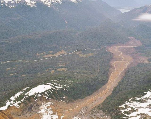
The debris trail from the Villa Santa Lucia rock avalanche. Image via @Sub_Interior on Twitter.
.
The trail suggest a high energy flow. It is a part of this landslide that struck the town of Villa Santa Lucia, with tragic consequences.
19 December 2017
The massive, catastrophic Villa Santa Lucia landslide in Chile: videos and images start to hint at the cause
The Villa Santa Lucia landslide: videos and images start to hint at the cause
Over the course of yesterday it slowly started to become clear that the Villa Santa Lucia landslide in Chile on Saturday was an extremely large failure event. The most important image that I have seen to date is this Reuters image of the source zone of the landslide:-
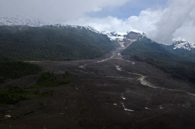
Reuters image of the source of the Villa Santa Lucia landslide, via t13cl
.
It is worth taking a closer look. In the image below I have merged the source area from the above image with the pre-failure Google Earth perspective view of the area. It is a bit clunky, but seems to indicate that this might be a massive failure of a moraine deposit at the glacier snout:-
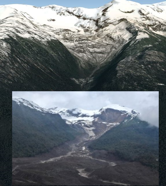
Merged Reuters and Google Earth imagery of the source of the Villa Santa Lucia landslide
.
The material involved in the flow appears to be consistent with the landslide being a combination of moraine and material that it has eroded from the hillsides and the channel. This makes the landslide track about 8 km from the source to Villa Santa Maria:-
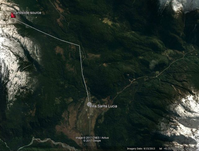
Approximate locations of the source, track and deposit of the Villa Santa Lucia landslide.
.
The best understanding of the track of the landslide comes from this Youtube video, which captures a helicopter flight up the valley from Villa Santa Lucia:-
.
The erosion of the channel suggests a very large volume flow, and the super-elevation around the bends suggest high velocities. I have found one video that captures the impact of the landslide on Villa Santa Lucia:
.
The latest news regarding the town of Villa Santa Lucia is that 12 people have been confirmed to have been killed, and a further 14 remain missing. The operation to recover the victims continues.
18 December 2017
Villa Santa Lucia: a deadly high mobility flow in Chile
Villa Santa Lucia: a deadly high mobility flow in Chile
On Saturday morning the community of Villa Santa Lucia in the Los Lagos area of southern Chile was struck by a large, high mobility flow, triggered by heavy rainfall. Images from the scene suggest that this was quite an unusual event:-
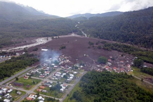
The aftermath of the landslide at Villa Santa Lucia in southern Chile on Saturday. Image via EPA-EFE/CHRISTIAN BROWN HANDOUT and News4Europe
.
Villa Santa Lucia is a small, reasonably isolated community in the very southern part of Chile. Reports suggest that at least eleven people have been killed, and up to 15 are reported to be missing. A further 12 people are reported to have been injured. These totals are likely to change as the picture becomes clearer over the next 24 hours.
The source of this landslide is not clear. It has traveled down a channel located upstream of the town, and the flow has spread across the existing fan upon which the town has been constructed. But on the Google Earth imagery of the area collected before the landslide there is no obvious source of the initial failure, and none is evident in the images that I have seen to date. There are some suggestions that the landslide may have been associated with detachment event on the Yelcho Glacier. Unfortunately this is an area with a very high level of cloud cover, so it may be a while before we can access satellite imagery that will help.
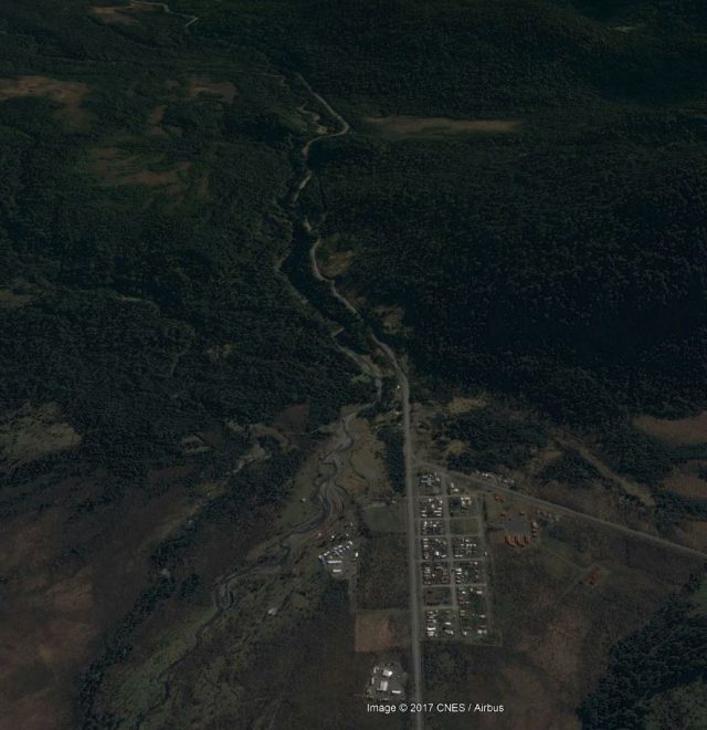
Google Earth imagery of Villa Santa Lucia in Chile prior to the landslide
.
Reports suggest that the area was affected by about 11.4 cm of rainfall in the 24 hour period leading up to the landslide. Fortunately the landslide occurred at 9:20 am local time. In a town of about 300 people, it is likely that this would have been higher had the landslide occurred in the night. The landslide is also reported to have impacted the school, suggesting that it was fortunate that the landslide occurred on a Saturday.
The paper that I co-authored with Dr Sergio Sepulveda a few years ago provides some context to landslides in Chile and in South America more generally. I will be traveling to Chile early in 2018.
15 December 2017
The Landslide Blog – the first ten years
The Landslide Blog – the first ten years
Tomorrow, 16th December, will mark the end 10th anniversary of The Landslide Blog. My first post on what was then Dave’s Landslide Blog was made whilst I was at the AGU Fall Meeting in San Francisco. I followed it up quickly with a couple more posts in those first few days. A back of the envelope calculation suggests I have probably made over 1,000 posts since then, and maybe nearer to 1,500. I moved the blog to the AGU blog site in October 2010, and have hugely appreciated the support that they have provided since. The stats of the blog since then continue to amaze me:

The Landslide Blog
I started the blog as an experiment, inspired by the attempts that the climate change community were making to connect communities. I set myself a target of 100 page views per day to make it viable – a target reached within the first year. The Landslide Blog is a labour of love, but it has been hugely enjoyable and rewarding. In many ways it is now a large part of my professional identity. I joined Twitter (@davepetley) a few years ago, and hugely enjoy that format of communication too. I have never mastered Instagram or Facebook.
Over that ten year period much has changed. Many of the blogs that inspired me have fallen away; I have changed jobs from Dean of Research at the University of Durham to Pro-Vice Chancellor at UEA and then to Vice-President (Research and Innovation) at the University of Sheffield, entailing a major relocation on each occasion. I have divorced, my son Adam has suffered serious illness ultimately requiring open heart surgery (he will be 16 next week and has completely recovered), and I have traveled extensively, most importantly with my daughter Holly (now 13) and Adam. Throughout the Landslide Blog has been my constant reference, and the community with whom it allows me to connect have been a great support.
In the time I have been blogging the wider perception of such activities has changed dramatically. When I started my employer considered the activity with considerable disapproval – the question asked was why I would do this rather than write journal papers. Over time that view has changed, and in my VP role here at Sheffield I openly promote the virtues of blogging. I think it has been good for my research, good for the take up of my work and good for me intellectually. It cannot and must not replace traditional research activities (especially writing research articles), and blogging is not for all, but it is certainly a worthwhile activity when done right.
I sometimes ponder what have been the highlights of the Landslide Blog for me. In the early days I wrote a great deal about the Tangjiashan valley blocking landslide in Sichuan. Of course for a time in 2010 the Attabad landslide was a very major concern, and I hope that the blog played a role in the management of that problem. The work undertaken with the wider community on piecing together the events that led to the Seti River landslide in Nepal also feels like a major, and unique, success.
Blogging has not been uniformly joyful. At the time of the Attabad landslide I received a series of offensive communications from a senior landslide scientist that were, at times, quite shocking. I eventually offered to travel to his institution in Europe to discuss it face-to-face, whereupon he stopped. I also received some surprising emails from a well-known landslide researcher on two occasions regarding posts I have made about another high profile (and more recent) landslide. But the vast majority of interactions have been warm, generous and supportive, and I have always appreciated the comments I have received about positive aspects of the blog, and those that have pointed out where corrections are needed. The good interactions have outweighed the bad by many, many times.
So what of the future of The Landslide Blog? Well, I have no intention of stopping in the forseeable future. Blogging is a great way to start my day when I arrive in work (I start very early) – it gets my brain functioning, it connects me to my research and it reminds me of what a university is for. I continue to write mainly about things that catch my attention, whether it is a new paper, a significant landslide event or a piece of artwork that features a landslide. I hope that I will be writing another piece like this a decade from now.
Finally thanks to those who have supported my work on the blog over the last ten years – my family, my colleagues and my friends. Many people have provided information or tipped me off to events. I would also like to thank the AGU and its staff – they have been wonderful hosts of The Landslide Blog, and their support is remarkable.
 Dave Petley is the Vice-Chancellor of the University of Hull in the United Kingdom. His blog provides commentary and analysis of landslide events occurring worldwide, including the landslides themselves, latest research, and conferences and meetings.
Recent Comments