18 December 2017
Villa Santa Lucia: a deadly high mobility flow in Chile
Posted by Dave Petley
Villa Santa Lucia: a deadly high mobility flow in Chile
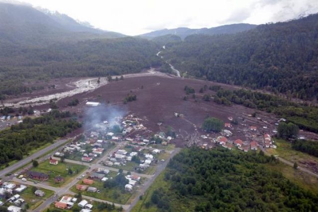
On Saturday morning the community of Villa Santa Lucia in the Los Lagos area of southern Chile was struck by a large, high mobility flow, triggered by heavy rainfall. Images from the scene suggest that this was quite an unusual event:-

The aftermath of the landslide at Villa Santa Lucia in southern Chile on Saturday. Image via EPA-EFE/CHRISTIAN BROWN HANDOUT and News4Europe
.
Villa Santa Lucia is a small, reasonably isolated community in the very southern part of Chile. Reports suggest that at least eleven people have been killed, and up to 15 are reported to be missing. A further 12 people are reported to have been injured. These totals are likely to change as the picture becomes clearer over the next 24 hours.
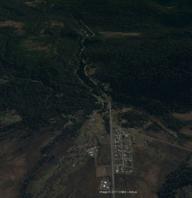
The source of this landslide is not clear. It has traveled down a channel located upstream of the town, and the flow has spread across the existing fan upon which the town has been constructed. But on the Google Earth imagery of the area collected before the landslide there is no obvious source of the initial failure, and none is evident in the images that I have seen to date. There are some suggestions that the landslide may have been associated with detachment event on the Yelcho Glacier. Unfortunately this is an area with a very high level of cloud cover, so it may be a while before we can access satellite imagery that will help.

Google Earth imagery of Villa Santa Lucia in Chile prior to the landslide
.
Reports suggest that the area was affected by about 11.4 cm of rainfall in the 24 hour period leading up to the landslide. Fortunately the landslide occurred at 9:20 am local time. In a town of about 300 people, it is likely that this would have been higher had the landslide occurred in the night. The landslide is also reported to have impacted the school, suggesting that it was fortunate that the landslide occurred on a Saturday.
The paper that I co-authored with Dr Sergio Sepulveda a few years ago provides some context to landslides in Chile and in South America more generally. I will be traveling to Chile early in 2018.


 Dave Petley is the Vice-Chancellor of the University of Hull in the United Kingdom. His blog provides commentary and analysis of landslide events occurring worldwide, including the landslides themselves, latest research, and conferences and meetings.
http://d2sh4fq2xsdeg9.cloudfront.net/contentAsset/image/8ca0e755-a932-40a7-a86b-a370fd352285/image/byInode/1/filter/Resize,Jpeg/jpeg_q/69/resize_w/960
Reuters image, it came from the mountains. Old landslides can be seen on upper section of this mountain on Google Earth.
Esteban is onto something. 2006 Google photos show recent rockfall further up the valley. Snow in 2016 photos appears to highlight complex bedrock structure and possibly several mid slope benches (Mass-wasting or sculpted by ice?). This might have been a rock/ice mix?
I agree, rock massif exhibits a likely fold and highly fractured structure. Could it be a removilization of the former north-slope rockslide?
Something interesting going on here, looks like mining:
https://www.google.co.uk/maps/dir/Carr+Austral,+Chait%C3%A9n,+X+Regi%C3%B3n,+Chile/-43.3096557,-72.416243/@-43.305066,-72.422672,1540m/data=!3m2!1e3!4b1!4m8!4m7!1m5!1m1!1s0x961e40d1196424b9:0x1ce9bd2d865abc0!2m2!1d-72.4198355!2d-43.3001109!1m0?dcr=0