
15 March 2019
Landslides induced by the 2010 Chile megathrust earthquake – my new paper
Landslides induced by the 2010 Chile megathrust earthquake – my new paper
On 27 February 2010 a huge earthquake occurred off the coast of Chile. With a magnitude of Mw=8.8, the 2010 Chile megathrust earthquake (also known as the Maule earthquake) was the sixth largest event in the instrument record, rupturing a section of fault 450 km from north to south and 150 km from east to west, and with a hypocentre depth of 37 km. This giant earthquake induced ground shaking across a large swathe of southern Chile, killing about 55o people and inducing financial losses in the order of US$4 – 7 billion.
This earthquake provided a perfect opportunity to examine landslides triggered by a large subduction earthquake; at present there are few such events in the global catalogues. So, as part of the Newton Fund project for which I was Principal Investigator, working with colleagues from the University of Chile, the University of Leeds and the University of Durham, we constructed an inventory of landslides triggered by this earthquake. The results have just been published in the journal Landslides (Serey et al. 2019).
The results are quite surprising. We were able to map just 1226 landslides in total, with a combined volume of just 10.56 million cubic metres. The coastal landslides pictured below, in the Arauco area, are examples of mass movement events triggered by the earthquake:-
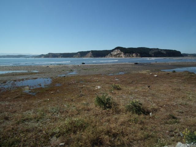
Coastal landslides triggered by the 2010 Chile Megathrust earthquake
The maps below, from the paper, show the landslide distribution from the 2010 Chile megathrust earthquake:-
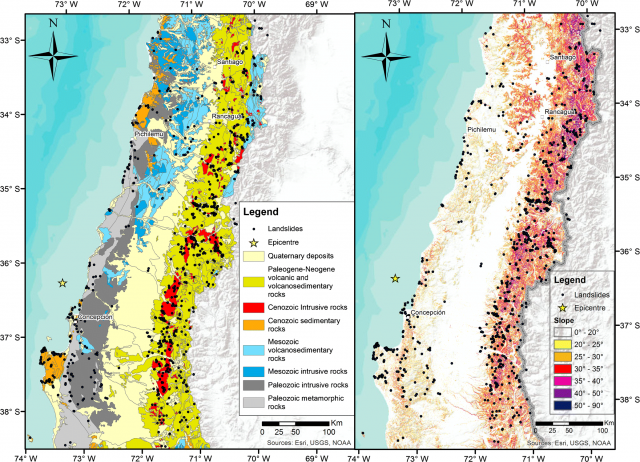
The landslide distribution from the 2010 Chile megathrust earthquake, compared to the bedrock geology (left) and slope angle (right). Image from Serey et al. (2019).
.
The landslide distribution extends throughout the area affected by intense ground shaking, but there are clear clusters. The majority of the landslides are located in the Principal Andean Cordillera (the area of higher slope angles inland) and a constrained region near the coast on the Arauco Peninsula in the southwest corner of the map. There is a strong control on landslide occurrence from both geology and slope angle, which is unsurprising. Less expected was the seismic parameter that best correlates with the landslide distribution. This is commonly expected to be peak ground acceleration, but in this earthquake we found that the ratio of horizontal and vertical peak ground accelerations appeared to be the key control.
I think though that the most important observation is in the number of landslides triggered by subduction zone earthquakes when compared with the inventories for other large seismic events. The graph below shows the total number of landslides plotted against the earthquake moment magnitude for a number of recent, large events with high quality inventories. Note that the y-axis is plotted on a log scale:-
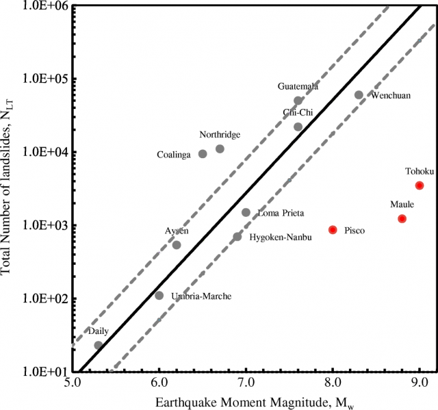
The relationship between the number of landslides and the earthquake magnitude for a number of large events, including the 2010 Chile megathrust earthquake. Figure from Serey et al. (2019).
.
The three red dots are the large subduction events. It is clear that all three generated very low numbers of landslides compared with other types of earthquakes. Whilst this is probably partly because of the availability of topography (a large part of the rupture occurs under the sea), this does not explain the low landslide numbers adequately. Serey et al. (2019) suggest that:-
“Earthquakes that generate fault rupture at the surface are likely to produce greater amounts of surface waves, which typically is what causes damage. We can speculate that a megathrust earthquake suffers much higher surface wave attenuation than shallow crustal earthquakes, triggering a smaller amount of landslides.”
Reference
Serey, A., Piñero-Feliciangeli, L., Sepúlveda, S.A. Poblete, F., Petley, D.N. and Murphy, W. 2019. Landslides induced by the 2010 Chile megathrust earthquake: a comprehensive inventory and correlations with geological and seismic factors. Landslides. https://doi.org/10.1007/s10346-019-01150-6
Acknowledgement
This work is supported by the RCUK-Conicyt Newton Fund International Cooperation Programme Project NE/N000315/1 “Seismically-induced landslides in Chile: New tools for hazard assessment and disaster prevention” and Fondecyt project 1140317.
14 March 2019
Losses from landslides in South Korea
Losses from landslides in South Korea
South Korea is a nation that at times has suffered significant losses from landslides. The map below shows fatal landslides in the region from 2004 to 2018, as documented in Froude and Petley (2018) and mapped using our online mapping tool:-
.
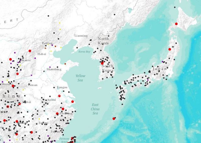
Recorded fatal landslides across East Asia from 2004 to 2017, including South Korea, from Froude and Petley (2018).
.
In a new paper in the journal Engineering Geology, my friends Su-Gon Lee and Mike Winter have documented loss inducing landslides in South Korea from 1970 to 2018 (Lee and Winter 2019). This is a very useful paper that carefully explains the context of landslides in South Korea (strongly seasonal rainfall, high erosion rates, dense human occupation, etc.). The have counted a total of 1728 fatalities from landslides in the period between 1970 and 2018, a total that was higher than I expected. The paper provides the following really interesting graph of these losses with time:-
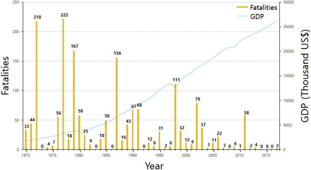
Annual landslide fatalities in South Korea from 1970 to 2018. Graph from Lee and Winter (2018).
.
Overall there is a good news story here in that the graph clearly shows a decreasing trend in losses with time, which Lee and Winter (2018) attribute to better landslide management:-
“This trend may be attributed to the fact that the government of the Republic of Korea has paid more attention to, and expended greater financial resource on, the safety of infrastructure, particularly that pertaining to transport, including landslide mitigation as GDP has increased and the country has become wealthier.”
The dreadful 2011 debris flows in Seoul stand to remind us that we can never be complacent though – the 58 fatalities that occurred in those events were clearly a significant shock. The authors also describe the non-fatal effects of landslides, noting that the estimated annual property damage is in the range of US$500 million to US$1 billion. Landslides are a problem along transportation infrastructure in particular.
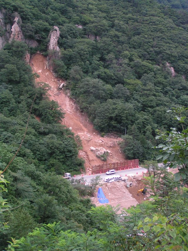
A roadside landslide in South Korea.
.
The image above, which I took when in South Korea with Su-Gon in 2007, nicely illustrates the problems posed by landslides in South Korea, and the mitigation measures needed to keep the population safe.
References
Froude, M. J. and Petley, D. N. 2018. Global fatal landslide occurrence from 2004 to 2016. Natural Hazards and Earth System Sciences, 18, 2161-2181, https://doi.org/10.5194/nhess-18-2161-2018.
Lee, S-G. and Winter, M.G. 2019. The effects of debris flow in the Republic of Korea and some issues for successful risk reduction. Engineering Geology, 251, 172-189. https://doi.org/10.1016/j.enggeo.2019.01.003
12 March 2019
Chengchao iron ore mine: severe subsidence induced by mining in China
Chengchao Iron Ore Mine: severe subsidence induced by mining in China
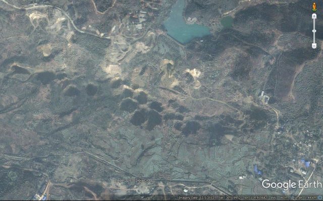
There is a nice article in a recent edition of the journal Engineering Geology (Xia et al. 2019) examining subsidence induced by the Chengchao iron ore mine, which is located in Ezhou City, Hubei Province, China. The paper describes the dramatic subsidence structures and explains their formation. The subsidence pits are remarkable – this is a recent Google Earth image that shows the craters that have formed:-
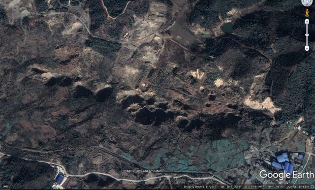
Subsidence features at the Chengchao iron ore mine in China. Image via Google Earth, collected in 2018.
.
The location is 30.319, 114.918 if you want to take a look. Mining started at the Chengchao iron ore mine in 1969, with the mining method focusing on sub-level caving. Subsidence started to be observed in the construction period for the mine (between 1958 and 1969), and it has extended thereafter. The subsidence is manifested on the surface primarily through the formation of large, deep pits, shown in the image below from Xia et al. (2019):-
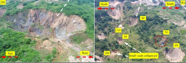
Subsidence pits formed at the Chengchao iron ore mine in China. Figure from Xia et al. (2019).
.
Xia et al. (2019) note that subsidence has occurred over an area measuring 1200 m x 300 m. Whilst the pits are the obvious manifestation of the subsidence, the authors note that the ground between the craters has also subsided substantially. In the centre of the worst of the pits the total vertical movement is up to 60 metres! The largest of the pits have a diameter of about 70 metres, and subsidence is continuing to develop across the area, with smaller, new pits forming in addition to the broad subsidence bowl.
Interestingly, Xia et al. (2019) conclude that the processes of subsidence at Changchao iron ore mine are complex. The geology consists of a faulted mixture of granite, marble, diorite and hornstone. Some of the collapses are located within the karst (marble) rocks, primarily as a result of changes in the groundwater conditions during dewatering for the mine. But in many other cases the caving technique has removed support from the overlying rocks, which have collapsed into the void. This process is ongoing – compare the image below, from 2012, with the one at the top of the page (from 2018). Several new pits have developed, and others have enlarged substantially:-
Subsidence features at the Chengchao iron ore mine in China. Image via Google Earth, collected in 2012.
.
The authors note that the subsidence has led to expensive works to relocate mining infrastructure. Fortunately, there are few non-mining assets in this area.
Reference
Kaizong Xia, Congxin Chen, Yun Zheng, Haina Zhang, Xiumin Liu, Yangyang Deng and Kuoyu Yang 2019. Engineering geology and ground collapse mechanism in the Chengchao Iron-ore Mine in China. Engineering Geology,
249, 129-147. https://doi.org/10.1016/j.enggeo.2018.12.028.
11 March 2019
A video of a small but spectacular rockslide from Uttarakhand
A video of a small but spectacular rockslide from Uttarakhand
A video has been posted onto Youtube showing a reasonably small but undeniably spectacular rockslide:-
.
In the comments section the location is described as being Uttarakhand, but no further details are provided. [Update – in a tweet SANDRP reports that the location is Bhatwadi in Uttarkashi district, and that the landslide happened last year] This appears to be to be as good an example as one could wish to find of a rockslide caused by discontinuities (joints) aligned with the slope – take a look at this still from the start of the video:-
The rock slope in Uttarakhand prior to the failure. Still from a video posted on Youtube by Sanjay Bisht.
.
The plane of weakness on which sliding occurred can be clearly seen. It appears that in constructing the road the toe of the landslide has been removed, leaving the rock blocks free to slide on that surface. Failure then occurs sequentially, with further failure of blocks at the toe of the slide destabilising the main rock mass. When sliding initiates the blocks move along this surface until free to fall:-
The rock slope in Uttarakhand as the the failure develops. Still from a video posted on Youtube by Sanjay Bisht.
.
Once free, the mass rapidly fragments, although some large blocks remain intact:-
Full failure of the rock slope in Uttarakhand. Still from a video posted on Youtube by Sanjay Bisht.
.
This is a fine example of the need to ensure that rock slopes are properly assessed and, where appropriate, engineered to prevent failure. The need for a proper engineering approach has been described in detail over the last 30 years by Dr Gareth Hearn. He has a good presentation summarising the key issues (NB PDF). The techniques for preventing this type of failure are well established and comparatively simple to implement, but in many mountain areas a combination of a lack of resource and a lack of expertise mean that this does not happen. The upshot is increased disruption, high levels of hazard and, when the slope fails, substantial environmental cost.
8 March 2019
Hooskanadan Landslide in Oregon – an update on the Highway 101 earthflow near to Brookings
Hooskanadan Landslide in Oregon – an update on the Highway 101 earthflow near to Brookings
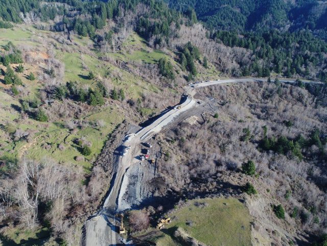
Reports in the last few hours suggest that Highway 101 near to Brookings in Oregon might reopen on Saturday, following its closure as a result of the major Hooskanadan landslide. Tideway Contractors have focused on constructing an initial unpaved route across the landslide body, with ramps of suitable grade, to allow a single vehicle lane to be established in the first instance. The challenge has been that the landslide has continued to move during this process. Early in the reinstatement process the landslide was moving at an estimated 2 feet (60 cm) per hour, but during the week this was reported to have declined to 6 inches (15 cm) per hour.
This image, from 11 KCBY, shows the magnitude of the movement at Hooskanaden Creek, and the challenges in reinstating the road:-
The displacement of US101 by the Hooskanadan landslide, north of Brookings. Image via 11 KCBY, ODOT and Tidewater Contractors.
.
The irony is of course that in emplacing fill on the landslide to create an appropriate grade, the contractors may have loaded the unstable portion of the slope, making movement slightly more likely. Unfortunately, in this type of situation it is the only realistic option, and it is an accepted management approach. The extent to which this has been necessary is better illustrated by this image, tweeted in the last few hours, showing the works from the other side:-
The extent of the earthworks on the Hooskanadan Landslide affecting Highway 101 north of Brooking in Oregon. Image tweeted by Tidewater Contractors
.
Regular correspondent funkenbeachin has pointed out to me some hydrograph data from Smith River, not far from the landslide, provided by the USGS. This seems to suggest a recent period of reasonably heavy rainfall, but conditions that are not particularly exceptional. There is no doubt that this slide will move again in the future, but the costs of permanent stabilisation are unlikely to be justifiable. The only realistic option is often to rebuild the road each time, and to accept the cost and inconvenience.
4 March 2019
Thanpal, Kashmir: three videos of the same massive rock slope failure
Thanpal, Kashmir: three videos of the same massive rock slope failure
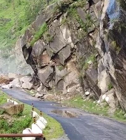
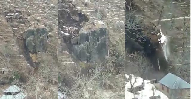
Three different videos have been posted on Youtube showing a very large, very dramatic rockslope failure near to Thanpal Dam in the Indian controlled portion of Kashmir. The landslide, which occurred on 2nd March 2019, has been associated with a period of heavy rainfall across the region, which has led to substantial damage. This first video gives a head on view of the landslide as it developed:-
.
Interestingly, it shows two phases of movement of the landslide, with the second phase being a failure in the crown of the slope that triggered further sliding downhill:-
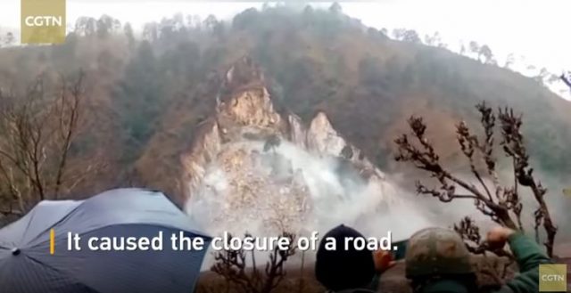
The large rockslope failure near to Thanpal Dam in Kashmir. Still from a video uploaded to Youtube
.
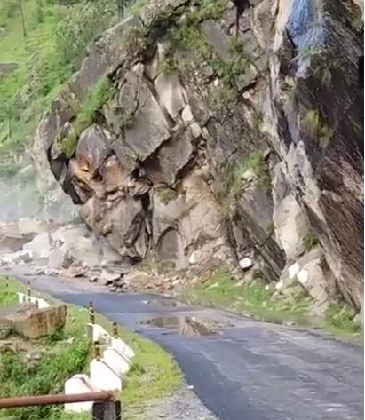
The second video shows the same landslide from a more oblique perspective:-
.
It shows a longer sequence of the failure, and also captures the way in which the landslide mobilises the existing debris pile in the valley, causing it to shount across sthe channel and then inducing a displacement wave:-
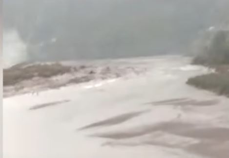
The mobilisation of debris in the channel, and the development of a displacement wave, by the large rockslope failure near to Thanpal Dam in Kashmir. Still from a video uploaded to Youtube
.
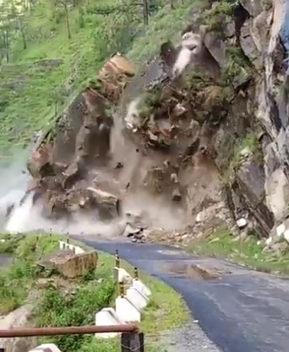
The third video gives a perspective that is similar to the second, but the orientation of the camera means that molre of the failure is seen. This video captures the mobilisation of the valley floor debris even better, and also gives a nice perspective of the wave as it propagates down the channel:-
.
Unsurprisingly the road is now blocked. There must be a strong suspicion here that this rockslope failure has been caused by cutting of the slope for the road. As such it is yet another example of inadequate highway engineering causing loss of infrastructure and serious, permanent environmental damage. It is completely unnecessary.
1 March 2019
US101 at Brookings: an interesting, disruptive landslide
US101 at Brookings: an interesting, disruptive landslide
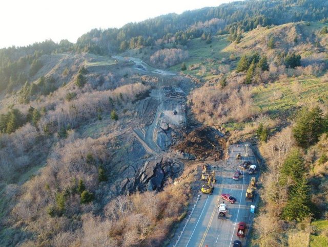
On Tuesday, significant movement occurred on a large landslide in Oregon, closing the important US101 highway near to the coastal town of Brookings. This landslide (location 42.219, -124.374), which seems to have been triggered by heavy rainfall, is captured very nicely in a drone image Tweeted by Tidewater Contractors:-
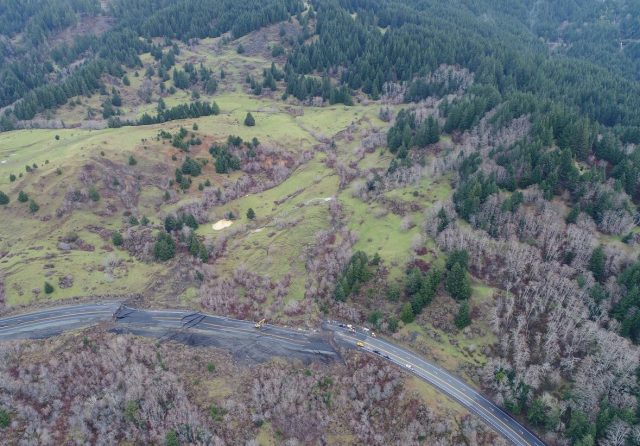
The major landslide on US101 at Brookings. Image via Tidewater Contractors on Twitter
.
Tidewater Contractors have also tweeted this rather splendid image of the main part of the landslide:-
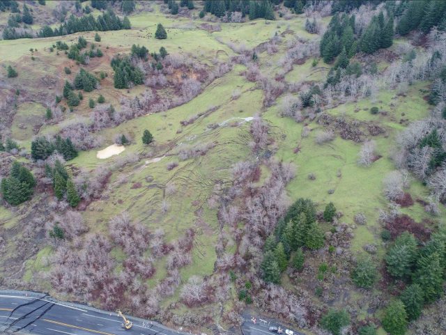
The main body of the US101 landslide near to Brookings in Oregon. Image tweeted by Tidewater Contractors.
.
This appears to be a large, moderately deep earthflow. Note the very clear scarps at the crown of the landslide and the beautiful array of tension cracks in the area in which the landslide mass steepened. Note also the very clear lateral scarps on the lower slopes towards the highway. The disruption to the road is very significant; Tidewater Contractors have tweeted a drone video showing the road damage, whilst the image below shows the impacts in more detail:-
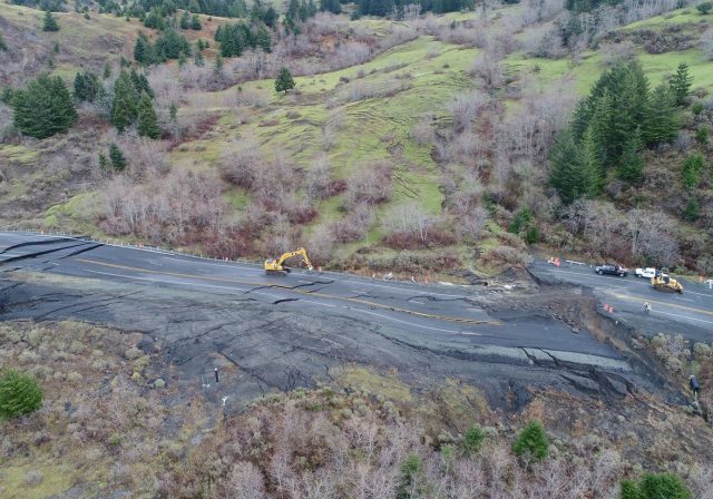
Road damage on Highway 101 near to Brookings caused by the large earthflow on Tuesday. Image tweeted by Tidewater Contractors.
.
There is an interesting article on Willamette Week that examines these types of landslide in Oregon in the context of climate change, drawing upon recent studies and expert knowledge. They note that these areas are being affected by both increases in groundwater level and by increased erosion of the coastal bluffs due to increased wave energy. This is the Google Earth imagery of the US101 landslide, with the image dated 3rd July 2016:-
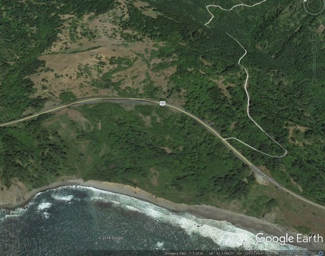
Google Earth imagery from July 2016 showing the site of the US101 landslide near to Brookings in Oregon.
.
The landslide is clearly identifiable in the Google Earth imagery, and there is evidence that movement has disrupted the road. The image demonstrates that the toe of the landslide is being eroded by wave action, leaving the slope more susceptible to the effects of increased groundwater levels.
The road is set to be closed for at least a month.
28 February 2019
Triggering and Propagation of Rapid Flow-like Landslides – The Proceedings of the Second JTC-1 Workshop
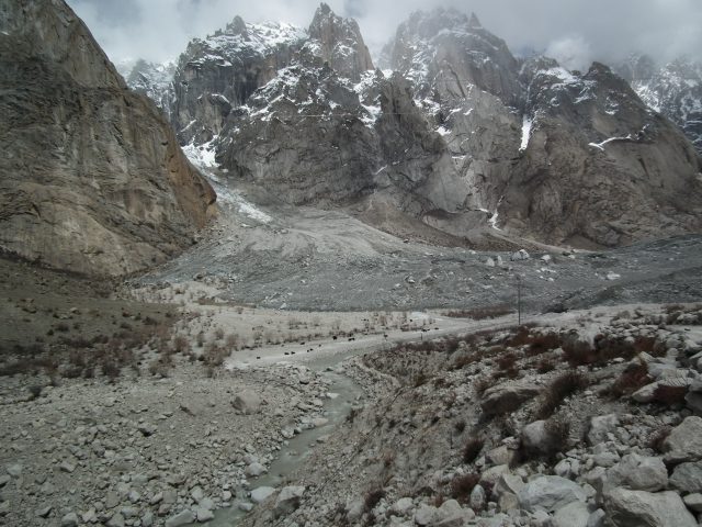
The 2012 Giyari landslide near to the Siachen glacier in northern Pakistan.
.
Triggering and Propagation of Rapid Flow-like Landslides – The Proceedings of the Second JTC-1 Workshop
Back in December JTC-1 organised a workshop, held in Hong Kong, on the Triggering and Propagation of Rapid Flow-like Landslides. This was a fascinating event, with a host of excellent presentations and some very interesting discussion. It included a benchmarking exercise that examined the state-of-the-art capability to model rapid and long run out flows.
The organisers of the conference have now placed the proceedings of the meeting, including the extended (four page) abstracts, online as a free resource. These are bundled into one PDF (warning – it is 65 MB), which represents a really useful resource.
26 February 2019
Two interesting new landslide videos from the Himalayas
Two interesting new landslide videos from the Himalayas
Heavy rainfall and snow over the Himalayas in recent days has triggered extensive landslides, with many roads being blocked. A couple of videos have emerged showing landslide events, both of which are quite interesting. The first for which there is little information, reportedly occurred in the Sainj Valley. It appears to show a debris flow passing across a road, with a trapped pick up truck. The vehicle is eventually lost to the flow:-
.
The flow is quite interesting in terms of a constant flow of fairly coarse sediment, although the flow rate appears to increase with time:-
The debris flow in the Sainj valley. Still from a video from Youtube.
.
The second video is an unusual collapse in a slope that combines weathered bedrock and a large unweathered block, which is undermined by the ongoing failure:-
.
The sequence of images below shows the evolution of movement of the large unweathered block, which starts by sliding, with a strong element of ploughing of the debris down slope, before the block starts to topple forward, at which point it rapidly fragments:-
The evolution of the larges, less weathered block in the landslide in the Himalayas. Still from a video posted to Youtube
.
The video shows the complex movement mechanisms of this types of slide. Interestingly, it is very unlikely that this would have been evident from the landslide scar and debris pile, which illustrates the challenges of back analysis of landslides without evidence of the morphology of the slope before the failure occurred.
Meanwhile, there has been a number of landslides in the US in recent days, including this example from WV-112, Ingleside Road in West Virginia:-
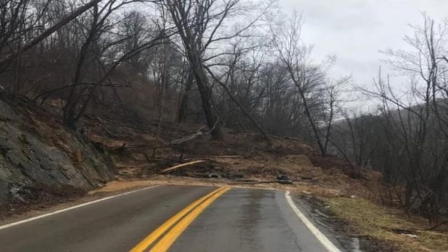
The landslide at Mercer County in West Virginia. Image from wdbj7.
.
This will take some effort to clear.
25 February 2019
The Baige landslide, Tibet: analysing seismic data to determine mass movement behaviour
The Baige landslide, Tibet: analysing seismic data to determine mass movement behaviour
Back in October 2018, a large landslide occurred in Tibet, temporarily blocking the valley. This landslide, which is located at 31.081, 98.706, and which I termed at the time the Jomda County rockslide, involved 24.5 million m³ of material, sliding over a distance of 1,400 metres. This was a bedrock landslide that created a debris pile 2 km long and 450 m wide, with a height of about 160 m. In one of my original posts about the landslide I included the following Planet Labs image:-
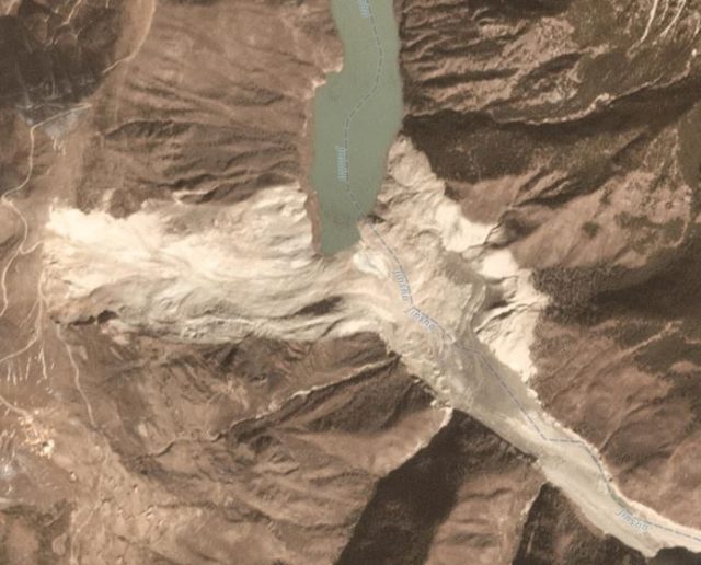
The major valley-blocking landslide at Baige in Tibet. Planet Labs 3-band PlanetScope scene collected on 12th November 2018, used with permission.
.
In a new paper just published in the journal Landslides, Zhang et al. (2019) have analysed the seismic signals generated by this large rockslope failure. This is the latest example of the use of seismic data to understand mass movement processes, an area of development that is very exciting at the moment. The analysis suggests that the initial failure occurred as a sliding block with a volume of about 7.8 million cubic metres. In the paper, Zhang et al. (2019) suggest that this was a block at the crown of the landslide, as per the diagram below:-
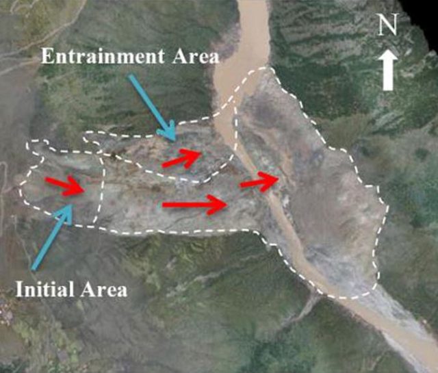
Interpretation of the behaviour of the Baige landslide in Tibet. Diagram from Zhang et al. (2019).
.
The seismic data suggest that the landslide then fragmented to form granular debris; within 50 seconds of initiation the block had completely disaggregated. The landslide eroded and entrained debris further down the slope, and the northern flank of the landslide (marked as the entrainment area above) also mobilised. The landslide movement was complete after 89 seconds. Interestingly, the material in the source area initially accelerated to 22 metres per second (about 80 km per hour, or 50 mph), but slowed slightly to about 18 metres per second when it encountered the resistance from the initially unfailed material on the lower slope. Thereafter it accelerated again to about 20 metres per second.
This is a fascinating study that demonstrates the ways in which seismic data can be used to understand the landslide processes. In the paper, Zhang et al. (2019) make the point that initial reports indicated that the landslide occurred in the morning of 11th October 2018, whilst the seismic data demonstrates definitively that the slide happened late in the evening of the previous day.
Reference
Zhang, Z., He, S., Liu, W. et al. 2019. Source characteristics and dynamics of the October 2018 Baige landslide revealed by broadband seismograms. Landslides. https://doi.org/10.1007/s10346-019-01145-3
Planet Team (2019). Planet Application Program Interface: In Space for Life on Earth. San Francisco, CA. Planet.com
 Dave Petley is the Vice-Chancellor of the University of Hull in the United Kingdom. His blog provides commentary and analysis of landslide events occurring worldwide, including the landslides themselves, latest research, and conferences and meetings.
Recent Comments