12 March 2019
Chengchao iron ore mine: severe subsidence induced by mining in China
Posted by Dave Petley
Chengchao Iron Ore Mine: severe subsidence induced by mining in China
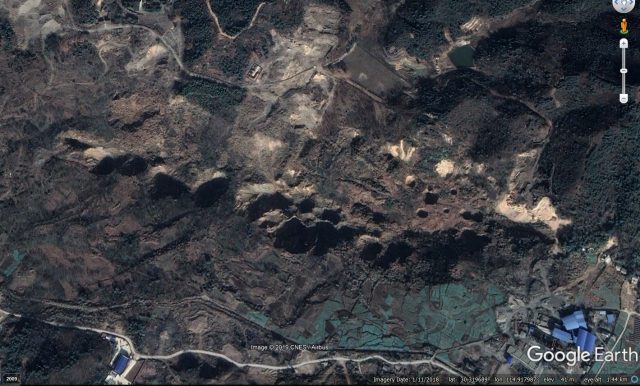
There is a nice article in a recent edition of the journal Engineering Geology (Xia et al. 2019) examining subsidence induced by the Chengchao iron ore mine, which is located in Ezhou City, Hubei Province, China. The paper describes the dramatic subsidence structures and explains their formation. The subsidence pits are remarkable – this is a recent Google Earth image that shows the craters that have formed:-

Subsidence features at the Chengchao iron ore mine in China. Image via Google Earth, collected in 2018.
.
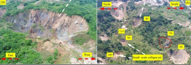
The location is 30.319, 114.918 if you want to take a look. Mining started at the Chengchao iron ore mine in 1969, with the mining method focusing on sub-level caving. Subsidence started to be observed in the construction period for the mine (between 1958 and 1969), and it has extended thereafter. The subsidence is manifested on the surface primarily through the formation of large, deep pits, shown in the image below from Xia et al. (2019):-

Subsidence pits formed at the Chengchao iron ore mine in China. Figure from Xia et al. (2019).
.
Xia et al. (2019) note that subsidence has occurred over an area measuring 1200 m x 300 m. Whilst the pits are the obvious manifestation of the subsidence, the authors note that the ground between the craters has also subsided substantially. In the centre of the worst of the pits the total vertical movement is up to 60 metres! The largest of the pits have a diameter of about 70 metres, and subsidence is continuing to develop across the area, with smaller, new pits forming in addition to the broad subsidence bowl.
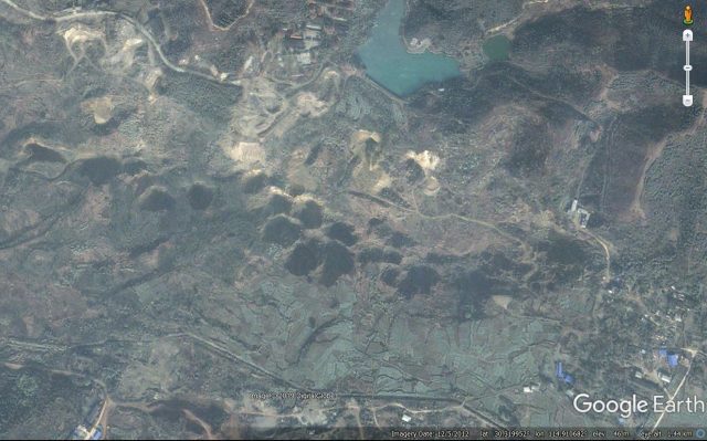
Interestingly, Xia et al. (2019) conclude that the processes of subsidence at Changchao iron ore mine are complex. The geology consists of a faulted mixture of granite, marble, diorite and hornstone. Some of the collapses are located within the karst (marble) rocks, primarily as a result of changes in the groundwater conditions during dewatering for the mine. But in many other cases the caving technique has removed support from the overlying rocks, which have collapsed into the void. This process is ongoing – compare the image below, from 2012, with the one at the top of the page (from 2018). Several new pits have developed, and others have enlarged substantially:-

Subsidence features at the Chengchao iron ore mine in China. Image via Google Earth, collected in 2012.
.
The authors note that the subsidence has led to expensive works to relocate mining infrastructure. Fortunately, there are few non-mining assets in this area.
Reference
Kaizong Xia, Congxin Chen, Yun Zheng, Haina Zhang, Xiumin Liu, Yangyang Deng and Kuoyu Yang 2019. Engineering geology and ground collapse mechanism in the Chengchao Iron-ore Mine in China. Engineering Geology,
249, 129-147. https://doi.org/10.1016/j.enggeo.2018.12.028.


 Dave Petley is the Vice-Chancellor of the University of Hull in the United Kingdom. His blog provides commentary and analysis of landslide events occurring worldwide, including the landslides themselves, latest research, and conferences and meetings.
There is a large Molybdenum mine (Henderson Mine) in Colorado that is eating the top of Red Mountain north of I-70 and west of Denver (roughly 39.75N/105.84W). I was fortunate to get a tour as part of a trade convention in the early 1990’s.
The operators drilled upward into the ore body in conical shot patterns w/the cone apexes converging downward at access tunnels within the mountain. In the past, when the ore being mined was very high grade, these “cones” became “automatic self-filling hoppers”: the massive moly deposits were so slick, they caved into the hoppers as material was removed at the bottom, propagating upward and eventually causing the mountaintop crater we see. The ore is/was hauled away using front-end loaders at the bottom. The waste rock is disposed of in a valley approximately 15 miles WNW as a pumped slurry in a manner reminiscent of the Fundao Mine and others in Brazil. Fortunately, the downhill region is relatively unpopulated.
PS: Google Earth has updated its toporaphic DEM so the recent imagery matches the existing topo reasonably well.
PPS: there are numerous large slide complexes in the region also. Many of these appear to be related to melting of glaciers that once supported the valley walls.
good is very good