
25 February 2019
The Baige landslide, Tibet: analysing seismic data to determine mass movement behaviour
Posted by Dave Petley
The Baige landslide, Tibet: analysing seismic data to determine mass movement behaviour
Back in October 2018, a large landslide occurred in Tibet, temporarily blocking the valley. This landslide, which is located at 31.081, 98.706, and which I termed at the time the Jomda County rockslide, involved 24.5 million m³ of material, sliding over a distance of 1,400 metres. This was a bedrock landslide that created a debris pile 2 km long and 450 m wide, with a height of about 160 m. In one of my original posts about the landslide I included the following Planet Labs image:-
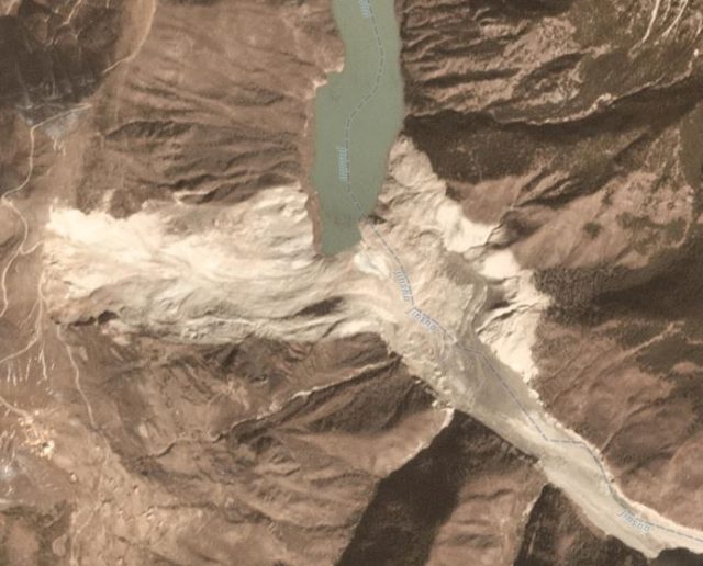
The major valley-blocking landslide at Baige in Tibet. Planet Labs 3-band PlanetScope scene collected on 12th November 2018, used with permission.
.
In a new paper just published in the journal Landslides, Zhang et al. (2019) have analysed the seismic signals generated by this large rockslope failure. This is the latest example of the use of seismic data to understand mass movement processes, an area of development that is very exciting at the moment. The analysis suggests that the initial failure occurred as a sliding block with a volume of about 7.8 million cubic metres. In the paper, Zhang et al. (2019) suggest that this was a block at the crown of the landslide, as per the diagram below:-
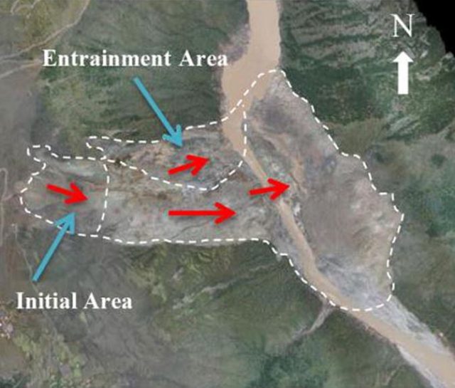
Interpretation of the behaviour of the Baige landslide in Tibet. Diagram from Zhang et al. (2019).
.
The seismic data suggest that the landslide then fragmented to form granular debris; within 50 seconds of initiation the block had completely disaggregated. The landslide eroded and entrained debris further down the slope, and the northern flank of the landslide (marked as the entrainment area above) also mobilised. The landslide movement was complete after 89 seconds. Interestingly, the material in the source area initially accelerated to 22 metres per second (about 80 km per hour, or 50 mph), but slowed slightly to about 18 metres per second when it encountered the resistance from the initially unfailed material on the lower slope. Thereafter it accelerated again to about 20 metres per second.
This is a fascinating study that demonstrates the ways in which seismic data can be used to understand the landslide processes. In the paper, Zhang et al. (2019) make the point that initial reports indicated that the landslide occurred in the morning of 11th October 2018, whilst the seismic data demonstrates definitively that the slide happened late in the evening of the previous day.
Reference
Zhang, Z., He, S., Liu, W. et al. 2019. Source characteristics and dynamics of the October 2018 Baige landslide revealed by broadband seismograms. Landslides. https://doi.org/10.1007/s10346-019-01145-3
Planet Team (2019). Planet Application Program Interface: In Space for Life on Earth. San Francisco, CA. Planet.com
 Dave Petley is the Vice-Chancellor of the University of Hull in the United Kingdom. His blog provides commentary and analysis of landslide events occurring worldwide, including the landslides themselves, latest research, and conferences and meetings.
The latitude given for this landslide seems to have suffered a typo. The previous article gives the correct latitude as 31.08 degrees.
i really like this website because you get really good information.
Interesting!