
8 July 2019
The Proceedings of the Second JTC1 Workshop: Triggering and Propagation of Rapid Flow-like Landslides
Proceedings of the Second JTC1 Workshop – Triggering and Propagation of Rapid Flow-like Landslides
.
The Proceedings of the Second JTC1 Workshop: Triggering and Propagation of Rapid Flow-like Landslides
Last December I was fortunate to attend the Second JTC1 Workshop: Triggering and Propagation of Rapid Flow-like Landslides, which was held at the Hong University of Science and Technology. This was an excellent event, well-atteneded with a series of very impressive and enjoyable presentations. The organisers have now compiled the proceedings of the meeting, which have been posted online via the conference website. They can also be downloaded directly (PDF). The volume contains short but insightful papers from all of the main contributions, and summaries of the discussion sessions.
The next major JTC1 event is the 13th International Symposium on Landslides, which will be held in Cartegena in Colombia from 15th to 19th June 2020.
5 July 2019
The Aizawl landslide: evidence from Google Earth of slope modification
The Aizawl landslide: evidence from Google Earth of slope modification
The landslide in Aizawl in Mizoram, India earlier this week, which I featured on Wednesday, caused the death of three people, including two children. The image below, from The Sentinel, provides an interesting perspective on the landslide. Once again it emphasises how fortunate it is that the buildings did not collapse completely:-
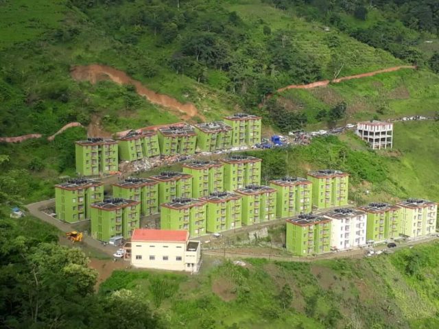
The Aizawl landslide, showing the three damaged apartment block. Image via The Sentinel.
.
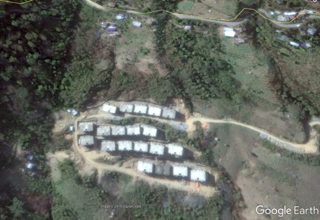
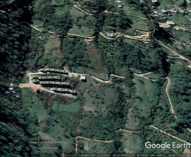
There is an excellent archive of Google Earth imagery for this site. As a reminder, here is an image from December 2018 showing the completed site and the slope that ultimately failed:-
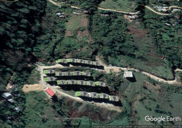
Google Earth image of the site of the Aizawl landslide. Image dated 30th December 2018.
.
By comparison, this image, dated 17th February 2006, shows the site prior to construction. Note the path across the slope that was widened to build the road:-
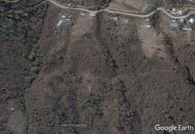
Google Earth image of the site of the Aizawl landslide. Image dated 17th February 2006.
.
But the revealing image of the side is the one below, dated 3rd December 2012, which shows the ground works at the site prior to the construction of the blocks:-
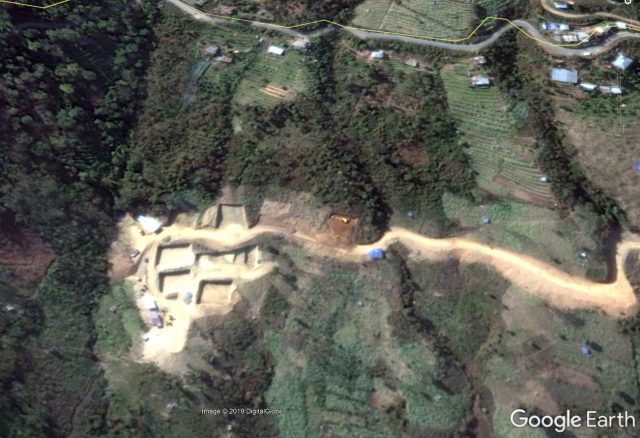
Google Earth image of the site of the Aizawl landslide. Image dated 3rd December 2012.
.
At the point at which this image was collected machinery was onsite excavating the foundation for the blocks in the row that was hit by the landslide this week. The footprint of other blocks is in place, and there is evidence of fill being emplaced lower down the slope. Note that the road has been constructed through cutting the slope and then emplacing fill on the downslope side.
A subsequent image, this time taken in 2014, appears to show that the slope was cut across the entirety of the length upslope of the apartments:-
Google Earth image of the site of the Aizawl landslide. Image dated 13th January 2015.
.
It is not clear as to the level of engineering works that were used to secure this cut slope, but the subsequent failure suggests that for whatever reason they were not adequate.
3 July 2019
Mizoram: three apartment buildings partially collapse after being hit by a landslide
Mizoram: three apartment buildings partially collapse after being hit by a landslide
In Mizoram in India, several large residential buildings were struck yesterday by a substantial landslide. Three of these buildings underwent collapse of their lower floor, although they fortunately remained upright, killing three people and injuring a further ten. Two of the victims were children. Images of the site suggest a dramatic event – the best set of images that I have seen are on the East Mojo website, which includes this overview of the landslide site:-
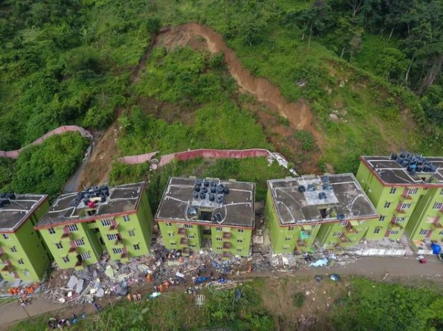
The aftermath of the landslide at Aizawl in Mizoram, India on 2nd July 2019. Image via East Mojo.
.
The landslide appears to be translational nature and to have occurred in residual soil and weathered rock. Note the smaller landslide scar, with a similar shape, to the right of the site of the slide event yesterday, also directly behind one of the apartment blocks. The image below shows that the three blocks were pushed forwards, with the lower floor collapsing in each case in a manner that is similar to a soft storey failure in an earthquake:-
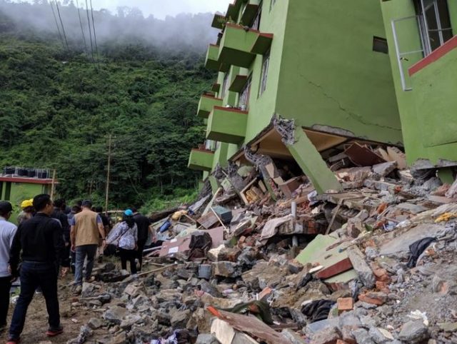
The collapse of the lower floor of the apartment blocks after the landslide at Aizawl in Mizoram, India on 2nd July 2019. Image via East Mojo.
.
Reports suggest that construction of these blocks began in 2009, but that progress had been slow such that the residents may have moved in last year. The landslide appears to have been triggered by heavy rainfall in the early part of the monsoon. Inevitably in an event like this there will be a focus on the degree to which the slope was cut to create the bench on which the apartment blocks were constructed. The houses were reportedly constructed by the National Project Construction Corporation (NPCC) as part of a government programme to provide accommodation for poor people in urban areas.
This Google Earth image appears to show the site of the landslide:-
Google Earth image of the site of the landslide at Aizawl in Mizoram, India on 2nd July 2019.
.
The slope that failed looks concerning, and there is a hint of slope modification in the image, but this needs further investigation.
2 July 2019
The huge September 2018 Naga landslide in the Philippines: a first published analysis
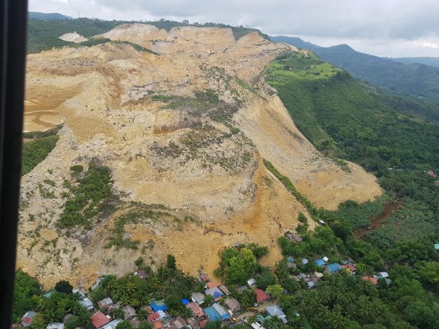
Overview of the 2018 Naga landslide. Image via Asian Policy Press.
The huge September 2018 Naga landslide in the Philippines: a first published analysis
The September 2018 Naga landslide was a 27 million cubic metre failure, associated with mining, on Cebu island in the Philippines, which killed 134 people and destroyed almost 60 houses:-
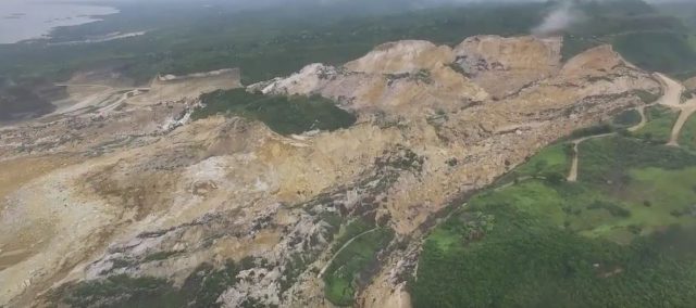
The September 2018 Naga landslide in the Philippines. Image via Youtube
.
The failure initiated in an area in which there had been extensive mining, and concerns about instability in the area had been raised ahead of the landslide. In a paper just published in the journal Landslides, Catane et al. (2019) provide a first analysis of this fascinating landslide. They have mapped the failure using a combination of methods, and have drawn information about activities on the slope prior to failure from a range of sources. There is some CCTV footage available of the time of failure, which has allowed detailed analysis of the initiation of the slide.
Interestingly, Catane et al. (2019) show that geologists from the Mines and Geosciences Bureau mapped the landslide site in August 2018 – the month before the failure – and logged extensive cracking across the slope, interpreted by the authors as extensional precursory indications of ongoing failure. These cracks are clearly documented on the following video, posted to Youtube:
.
These cracks show that the slope was creeping for at least three weeks prior to the failure event. In response local residents in Sitio Tagaytay were evacuated. Sadly, as no estimate of the long runout of the landslide was possible (the landslide traveled a distance of 1.34 km), the residents further along the track were not relocated. It was these people who became the casualties of the landslide.
Catane et al. (2019) interpret the landslide as being a low angled block slide, noting that many of the limestone blocks remained intact and upright. The landslide moved at a velocity of up to about 8 metres per second, which seems quite rapid, but not exceptional, for such a failure. In retrospect the runout distance is also not exceptional given total vertical extent of 210 metres and the large volume of the landslide.
An initial analysis of the stability of the slope suggests that prior to failure the slope might have been in a pseudo-unstable state, even under dry conditions. This should lead to considerable scrutiny of the mining operations. Interestingly, the authors find no evidence for a direct trigger event for the final failure of the Naga landslide, having analysed both meteorological and seismic data, implying that this was a classic progressive failure event.
The event now seems to be a prime location for a back analysis using INSAR data. The results are likely to be very revealing – I suspect that it will show that deformation was developing over a much longer time period than was observed at the site.
Overall, this is an excellent first review of this very important landslide. The tragedy is of course that signs of instability were apparent long before the slope collapsed. Finding effective mechanisms to identify the potential for such a site to undergo rapid failure must continue to be a priority.
Reference
Catane, S.G., Veracruz, N.A.S., Flora, J.R.R. et al. 2019. Mechanism of a low-angle translational block slide: evidence from the September 2018 Naga landslide, Philippines. Landslides. https://doi.org/10.1007/s10346-019-01212-9
1 July 2019
Iliamna Volcano landslide: a new image from the Alaska Volcano Observatory
Iliamna Volcano landslide: a new image from the Alaska Volcano Observatory
The Alaska Volcano Observatory has released a new, high quality, three dimensional rendering of the Iliamna Volcano landslide on 20th June 2019. The image uses PlanetSope near-infrared data draped onto Google Earth topography to give a clear impression of the size and scale of the failure:-
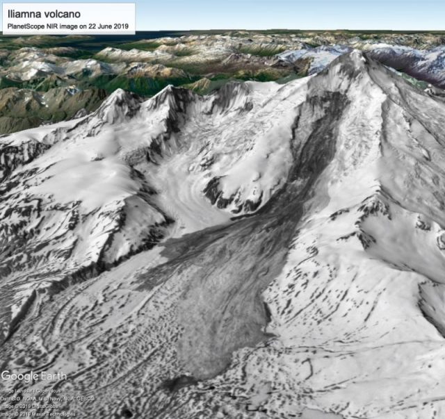
PlanetScope near-infrared scene from June 22nd, 2019 (approx. 2 days after June 21 Red Glacier avalanche) converted to grayscale and draped over Google Earth topography. Direction of view is approximately WSW. Image created by the Alaska Volcano Observatory.
.
Interestingly, twelve years ago an analysis of seismic data associated with six large ice and rock avalanches on Iliamna volcano was published (Caplan-Auerbach and Huggel 2007). They note that at least eight events with a volume in the order of a million cubic metres occurred on Iliamna volcano between 1984 and 2005. They explain this high frequency of large mass movements as follows:
There are several factors likely to be contributing to the frequency and volume of these events. A primary factor is the large volume of ice available for failure (Trabant, 1999). Furthermore, although the volcano has no confirmed historic eruptions, it has active fumaroles and experienced a dike intrusion in 1996 (Roman and others, 2004). Volcanic unrest could promote ice avalanches by increasing heat flux within the edifice, melting the base of the glacier cover and promoting slip at the glacier base. Furthermore, Iliamna’s exposed rock is heavily altered by hydrothermal activity, and is prone to failure (Waythomas and others, 2000). Avalanches may initiate in rock or they may entrain friable rock as they travel. This not only enhances avalanche volume but increases the density of the avalanche material, imposing a larger force upon the ground and thus increasing the amplitude of seismic signals associated with the avalanche.
Also of note is the timing of these major landslides. Caplan-Auerbach and Huggel (2007) noted that:
The majority of Iliamna Volcano events occur in the spring or summer, suggesting that they are triggered by increases in meltwater along the glacial base, possibly promoted by crevasse opening at the headwall.
This is consistent with observations elsewhere in Alaska. Rock and ice avalanches, such as the Iliamna Volcano landslide, can be a major hazard to mountain communities, as the tragic Giyari landslide showed in 2012. Understanding these events better is clearly important.
Reference
, C. 2007. Precursory seismicity associated with frequent, large ice avalanches on Iliamna volcano, Alaska, USA. Journal of Glaciology, 53, issue.180, pp.53-128. DOI : 10.3189/172756507781833866
28 June 2019
The chains of geologic hazards arising from earthquakes
The chains of geologic hazards arising from earthquakes
In recent years there has been a growing appreciation of the ways in which large earthquakes in mountainous areas trigger chains of geologic hazards that last for years after the main shock. I featured a great example of this in the early days of this blog, back in 2008, when the Wenchuan earthquake triggered the valley-blocking landslide at Tangjiashan, which in turn impounded a huge lake that threatened downstream communities. The 1999 Chi-Chi earthquake triggered detailed investigations of these processes, and was a turning point in the appreciation of the impacts and consequences of large earthquakes in mountain areas. The 2008 Wenchuan earthquake, which was the most significant landslide-generating event of my career, has allowed a huge number of detailed studies of these effects.
In a simply wonderful paper just published in Reviews of Geophysics, which is open access, Fan et al. (2019) review the literature on chains of geologic hazards arising from large earthquakes, with a focus on the Ch-Chi and Wenchuan earthquakes. The body of literature is huge, so this has been a monumental task, but the result is a paper that is rich in detail and nuance. I could write in detail about various aspects of it, but here I will focus on just one element. Many studies have considered the distribution of landslides across the landscape, in particular in relation to proximity to the surface expression of the fault that ruptured. For example, we have looked carefully at this effect for the Kaikoura earthquake (see Massey et al. 2018), and in general it is well established that proximity to the fault is a key factor controlling the likelihood of landsliding. Fan et al. (2019) summarise this effect in a very powerful diagram, showing the ways that the type of faulting changes the distribution:-
.
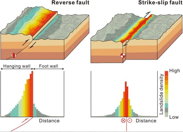
Chains of geologic hazards: the distribution of landslides triggered by earthquakes. Diagram from Fan et al. (2019)
.
The diagram very neatly summarises the key effects that drive the chains of geologic hazards –
- Proximity to the fault is the key spatial control on landsliding;
- The effect varies according to the type of faulting observed;
- For reverse faults, the majority of the landslides occur on the hanging wall block, with comparatively few on the footwall side;
- For reverse faults, the area affected by landslides can extend long distances from the surface expression of the fault on the hanging wall side;
- For strike-slip faults, the landslides tend to be more evenly distributed across the fault, with the area affected by landslides extending shorter distances from the surface expression of the fault.
This is a complex pattern that the diagram summarises well. The image below shows a part of the area affected by the 2008 Wenchuan earthquake, which was primarily a reverse faulting event. The landslide distribution illustrates the point made by Fan et al. (2019) elegantly:
.
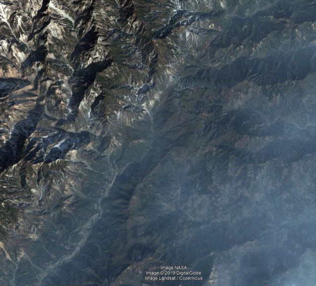
Chains of geologic hazards: landslides triggered by the 2008 Wenchuan earthquake. The fault runs SW-NE across the image, with the hanging wall block on the northwest side. Note the difference in landslide density in the north west compared to the south east. Image from Google Earth.
I am sure that the diagram from Fan et al. (2019) will appear in numerous lectures in the future.
The paper has many other insights into the chains of geologic hazards from large earthquakes. It is an important and interesting contribution that will become a classic.
References
27 June 2019
Mount Iliamna: a large landslide in Alaska on 20th June 2019
Mount Iliamna: a large landslide in Alaska on 20th June 2019
A very large landslide occurred on the flanks of Mount Iliamna, a volcano located in Alaska, on 20th June 2019. The landslide has been described by the Alaska Volcano Observatory, who have posted a number of images of the aftermath. The best of these was taken by Loren Prosser on the day after the landslide:-
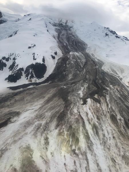
The large landslide on the flanks of Mount Iliamna on 21st June 2019. Image by Loren Prosser, posted by the Alaska Volcano Observatory.
.
The caption for the image is as follows:
Photo of Red Glacier avalanche that occurred on 6/21 ~00:05 UTC (6/20 ~4:05 pm AK). Description from the photographer: “attached pics from a fly by this past Friday evening. The slide appeared a few days old at that point, and seemed to originate near the summit. The slide & debris are visible from across the inlet now as well. Debris field approx 2+ miles wide & the toe. Pretty impressive slide altogether!”
The landslide has been captured by a Sentinel 2 satellite image that is available via the Sentinel Hub:-
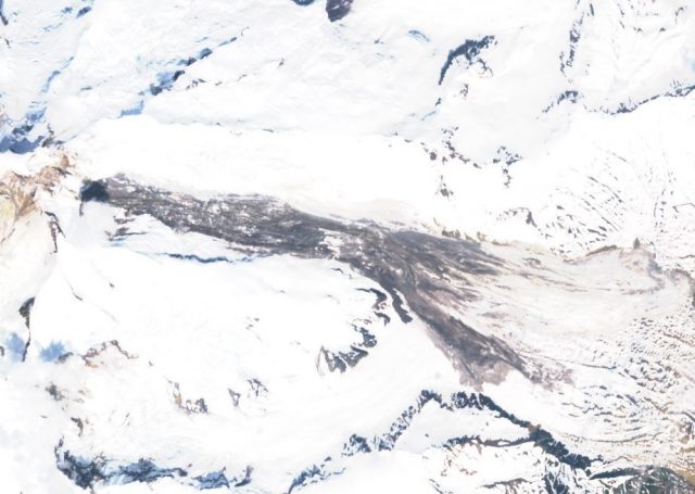
A Sentinel 2 image, collected on 25th June 2019, showing the Mount Iliamna landslide. Image via Sentinel Hub Playground.
.
The landslide appears to be in the order of about 6 km in length, and over 2 km wide at the toe. This image, also via the Alaska Volcano Observatory, and taken by Dennis Anderson on 22nd June 2019, gives a better impression of the scale of the event:-
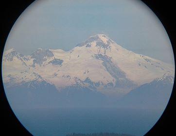
The Mount Iliamna landslide. Image collected by Dennis Anderson and posted online by the Alaska Volcano Observatory.
.
The caption for this image states:
Rockslide on Iliamna volcano on 6/21/2019. This image was taken around 11:00 am on 6/22/2019 by Dennis Anderson from Diamond Ridge NW of Homer using a tablet at the eyepiece of some 11×80 binoculars with a 4.5 degree field of view. This might have occurred sometime in the past 12-48 hours as Illiamna was obscured by clouds most of yesterday.
The trigger of this landslide is not clear, but Alaska has experienced a series of very large landslides (often in the early part of the summer) in recent years, including Juneau, Icy Bay / Tyndall Glacier, Glacier Bay / Lamplugh, and Sitka. There is good evidence that this is associated with climate change.
24 June 2019
Salaks: an unusual video of a landslide impact in Norway
Salaks: an unusual video of a landslide impact in Norway
On 8th June 2019 a landslide struck the Salaks salmon processing plant in the northern part of Norway, severely damaging the building and some of its equipment, and shutting the works down. Various news agencies reported the story in Norwegian at the time. Some included this image of the aftermath of the site:-
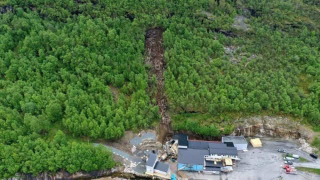
The landslide that damaged the Salaks plant in Norway. Image by Universitetssykehuset Nord-Norge via NRK.
.
The failure appears to be a collapse of a rock bluff above the plant, with the debris following the slope to the bottom of the hill. There is some entrainment, most notably of trees. The landslide appears to have struck the corner of the plant.
Salaks have released CCTV video of the landslide striking the Salaks factory. It includes two different views, one within the building and one from a camera mounted outside. Unfortunately I cannot embed this video, but if not it can be viewed here. It is worth a look.

The landslide at the Salaks plant in Norway. Still from a video of CCTV footage released by the company. The video can be viewed on the Intrafish website.
.
Although this is a comparatively small landslide, the violence and power of the event is clear. It is fortunate that there was no-one in the path of the landslide.
The news reports indicate that Salaks are still not able to enter the building, and so the full extent of the damage is not yet established. It is the second blow to the company this summer, which has been facing the impact of an algal bloom, damaging its fish stocks. The plant has about 25 employees in total, none of whom are able to work at present. Reports suggest that these individuals have had to be temporarily laid off.
21 June 2019
Debris Flow Hazards Mitigation: Mechanics, Monitoring, Modeling and Assessment
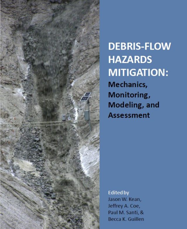
Debris-flow hazards mitigation : mechanics, monitoring, modeling, and assessment
Debris Flow Hazards Mitigation: Mechanics, Monitoring, Modeling and Assessment
Earlier this month, from 10th to 13th June 2019, the Seventh International Conference on Debris-Flow Hazards Mitigation was held in Golden, Colorado. This was a substantial meeting focusing on the mechanics, monitoring, modeling and assessment of this very major hazard. Only yesterday I highlighted a serious debris flow disaster in the Trabzon region of Turkey. According to the organisers of the conference, the aim of major objective of the meeting was to provide a forum for international researchers, engineers, and policy makers to exchange ideas and promote communication to advance the scientific understanding of debris-flow hazards as well as approaches to assess and mitigate debris-flow risk to infrastructure and people. It looks to have been an excellent event, which included 14 keynote presentations, 38 presentations and 86 posters.
Remarkably, the conference hosts have posted the proceedings of the meeting online, free to download. The volume consists of 134 papers looking at all aspects of debris flows. There are some detailed case studies; analyses of past and historic events; simulations and models; physical experiments; and descriptions of mitigation approaches. Some of the papers examine events that I have described on this site, such as the 2018 Montecito debris flows in California, whilst others look at events that are new to me. The quality of the papers is very high, and there are some fascinating contributions.
The organisers have kindly posted the various sections of the volume separately, as well as a single PDF for the entire volume. These are listed below:-
- Front matter and table of contents (610.0Kb)
- Processes and mechanics (pages 1 – 75) (6.497Mb)
- Monitoring, detection, and warning (pages 76 – 229) (24.40Mb)
- Experiments and modeling (pages 230 – 474) (19.88Mb)
- Role of disturbance (pages 475 – 547) (7.476Mb)
- Case studies and hazard assessments (pages 548 – 918) (34.96Mb)
- Engineering and mitigation (pages 919 – 1050) (11.15Mb)
- Author index (pages 1051 – 1055) (549.7Kb)
- Full conference proceedings (98.98Mb)
This is a very helpful record of the state of the art in debris flow science and engineering. The next meeting the Eighth International Conference on Debris-Flow Hazards Mitigation will be held in Turin, Italy, presumably in 2023. Details will be available in due course.
Reference
Kean, J.W., Coe, J.A., Santi, P.M. and Guillen, B.K. 2019. Debris-flow hazards mitigation : mechanics, monitoring, modeling, and assessment. Proceedings of the Seventh International Conference on Debris-Flow Hazards Mitigation, Golden, Colorado, USA, June 10-13, 201. Association of Environmental and Engineering Geologists, Special Publication 28.
20 June 2019
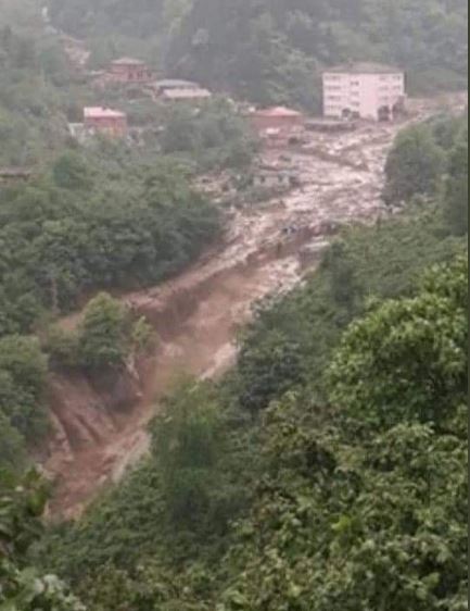
Arakli: devastating debris flows in Trabzon province in Turkey yesterday
Arakli: devastating debris flows in Trabzon province in Turkey yesterday
Intense rainfall yesterday (19th June 2019) in Trabzon province in Turkey triggered a series of devastating debris flows in the hilly Arakli area close to the Black Sea coast. News reports suggest that seven people are known to have died in the disaster, and a further seven people are missing. Worst affected appears to be the communities of Çamlıktepe and Yeşilyurt, in the Arakli area, where reports suggest that ten lives have been lost. This image, from mynet.com, gives a good perspective of the aftermath of one of the affected areas:-
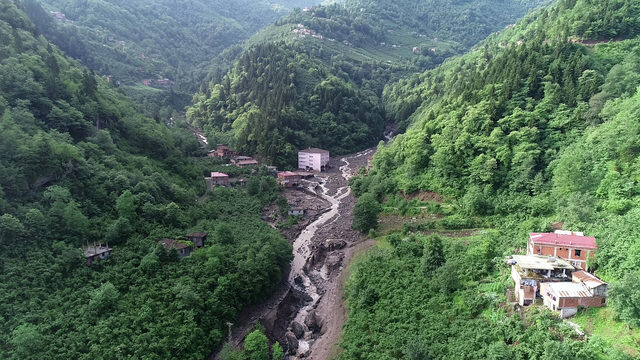
The aftermath of one of the debris flows at Arakli in Trabzon, Turkey. Image via mynet.com
.
There are some images available via Twitter that show this site during the main part of the event:-
An image, posted to Twitter, showing the debris flow at Arakli in Turkey on 19th June 2019
.
There is also a short video on Twitter that appears to show the arrival of one of the debris flow waves. This is an uncomfortable video to watch as the terror of the person filming the event is very clear.
There is an article in English on the Daily Sabah about this event. Interestingly, it suggests that the debris flows may have been associated with landslides upstream:-
“Interior Minister Süleyman Soylu, who was a former lawmaker from Trabzon, joined Agriculture and Forestry Minister Bekir Pakdemirli for a visit to the flooded areas yesterday. Soylu told reporters that the epicenter of the disaster was the confluence of two rivers and heavy rainfall hitting a hill where the neighborhoods are located triggered landslides.”
However, there is also a strong suggestion in the Turkish media that a hydroelectric scheme located upstream may also have played a role, although it is not clear to me as to how this might have occurred. Images over the next few days may shed light on that, although further rainfall is forecast.
 Dave Petley is the Vice-Chancellor of the University of Hull in the United Kingdom. His blog provides commentary and analysis of landslide events occurring worldwide, including the landslides themselves, latest research, and conferences and meetings.
Recent Comments