
2 July 2019
The huge September 2018 Naga landslide in the Philippines: a first published analysis
Posted by Dave Petley
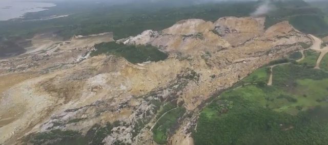
Overview of the 2018 Naga landslide. Image via Asian Policy Press.
The huge September 2018 Naga landslide in the Philippines: a first published analysis
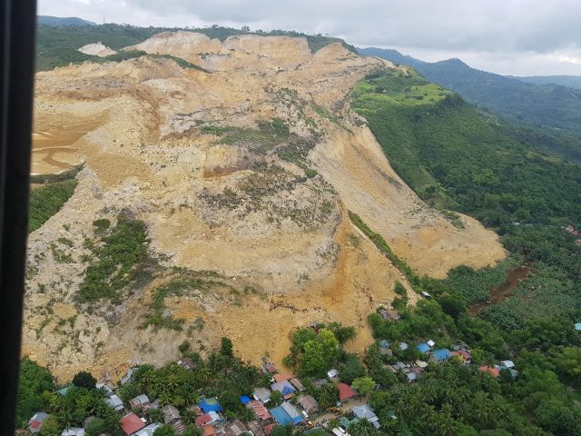
The September 2018 Naga landslide was a 27 million cubic metre failure, associated with mining, on Cebu island in the Philippines, which killed 134 people and destroyed almost 60 houses:-
The September 2018 Naga landslide in the Philippines. Image via Youtube
.
The failure initiated in an area in which there had been extensive mining, and concerns about instability in the area had been raised ahead of the landslide. In a paper just published in the journal Landslides, Catane et al. (2019) provide a first analysis of this fascinating landslide. They have mapped the failure using a combination of methods, and have drawn information about activities on the slope prior to failure from a range of sources. There is some CCTV footage available of the time of failure, which has allowed detailed analysis of the initiation of the slide.
Interestingly, Catane et al. (2019) show that geologists from the Mines and Geosciences Bureau mapped the landslide site in August 2018 – the month before the failure – and logged extensive cracking across the slope, interpreted by the authors as extensional precursory indications of ongoing failure. These cracks are clearly documented on the following video, posted to Youtube:
.
These cracks show that the slope was creeping for at least three weeks prior to the failure event. In response local residents in Sitio Tagaytay were evacuated. Sadly, as no estimate of the long runout of the landslide was possible (the landslide traveled a distance of 1.34 km), the residents further along the track were not relocated. It was these people who became the casualties of the landslide.
Catane et al. (2019) interpret the landslide as being a low angled block slide, noting that many of the limestone blocks remained intact and upright. The landslide moved at a velocity of up to about 8 metres per second, which seems quite rapid, but not exceptional, for such a failure. In retrospect the runout distance is also not exceptional given total vertical extent of 210 metres and the large volume of the landslide.
An initial analysis of the stability of the slope suggests that prior to failure the slope might have been in a pseudo-unstable state, even under dry conditions. This should lead to considerable scrutiny of the mining operations. Interestingly, the authors find no evidence for a direct trigger event for the final failure of the Naga landslide, having analysed both meteorological and seismic data, implying that this was a classic progressive failure event.
The event now seems to be a prime location for a back analysis using INSAR data. The results are likely to be very revealing – I suspect that it will show that deformation was developing over a much longer time period than was observed at the site.
Overall, this is an excellent first review of this very important landslide. The tragedy is of course that signs of instability were apparent long before the slope collapsed. Finding effective mechanisms to identify the potential for such a site to undergo rapid failure must continue to be a priority.
Reference
Catane, S.G., Veracruz, N.A.S., Flora, J.R.R. et al. 2019. Mechanism of a low-angle translational block slide: evidence from the September 2018 Naga landslide, Philippines. Landslides. https://doi.org/10.1007/s10346-019-01212-9
 Dave Petley is the Vice-Chancellor of the University of Hull in the United Kingdom. His blog provides commentary and analysis of landslide events occurring worldwide, including the landslides themselves, latest research, and conferences and meetings.
Interestingly, the report of the Mines and Geoscience Bureau in August 2018, the month before the landslide, was this!
Letter to Naga City Mayor, Kristine Chiong by the Mines and Geosciences Bureau.
“Pls be informed that, based on the technical report, the manifestation fissures/cracks in the subject site is a natural phenomenon and is not related to the mining operation within the ALQC Tenement in Sitio Tagaytay, Barangay Tinaan, Naga City, Cebu. Further, the present nature, the number, and the distribution of cracks/fissures in the subject site are not considered critical and do not pose immininent danger to the adjacent community.”
https://www.facebook.com/photo.php?fbid=10212796303357616&set=a.1316446826450&type=3&sfns=mo
Se puede pensar en la pedida de la cohesion aparente de suelo, tambien en la degradación de calizas que genera dolinas y cavernas convertidas en reservorios de aguas que pueden desatar repentinos flujos de aguas subterraneas aun en temporada seca.
Are you sure what you are saying about that the tragedy is a natural phenomenon? The * statement is that im one of those victims im from sitio tagaytay and i know that the mining cause that landslide 3-4 weeks before the landslide the apo cement quarry keep on operating above the mountain which was our location of our houses are there and then 1 week after the operation each of us discovered small cracks in our location where the mining is keep on operating. Even in our houses there is crack and then days past the cracks becane more bigger and the quaary operation still going they didn’t even care to us even if we told them about that crack situation and then 3 weeks passes we are the night before the tragedy we are evacuated in guanzon beach and early in that morning the landslide happen we are glad that we evacuated that night before the tragedy. So what the fuck are you saying that its a natural phenomenon.
[I have no idea what you are talking about. I clearly state:
The September 2018 Naga landslide was a 27 million cubic metre failure, associated with mining, on Cebu island in the Philippines, which killed 134 people and destroyed almost 60 houses.
And
The failure initiated in an area in which there had been extensive mining, and concerns about instability in the area had been raised ahead of the landslide.
D.]